Brebières
Brebières | |
|---|---|
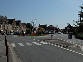
 The Place des héros, in Brebières | |
| Coordinates: 50°20′15″N 3°01′25″E / 50.3375°N 3.0236°E | |
| Country | France |
| Region | Hauts-de-France |
| Department | Pas-de-Calais |
| Arrondissement | Arras |
| Canton | Brebières |
| Intercommunality | CC Osartis Marquion |
| Government | |
| • Mayor (2020–2026) | Lionel David[1] |
| Area 1 | 10.8 km2 (4.2 sq mi) |
| Population (2021)[2] | 5,169 |
| • Density | 480/km2 (1,200/sq mi) |
| Time zone | UTC+01:00 (CET) |
| • Summer (DST) | UTC+02:00 (CEST) |
| INSEE/Postal code | 62173 /62117 |
| Elevation | 25–48 m (82–157 ft) (avg. 43 m or 141 ft) |
| 1 French Land Register data, which excludes lakes, ponds, glaciers > 1 km2 (0.386 sq mi or 247 acres) and river estuaries. | |
Brebières is a commune in the Pas-de-Calais department in the Hauts-de-France region in northern France.[3]
Geography[edit]
This farming and light industrial town is located 12 miles (19 km) east of Arras on the N50 road, at the junction with the D44 and D307, by the banks of the Scarpe river.
A celebration of the potato takes place annually on the first Sunday in September.
History[edit]
Evidence of occupation from Merovingian times has been unearthed. In 2008, during the creation of the 60 hectare Bèliers industrial zone, three important archaeological sites, once occupied by Gauls and Celts, were discovered. Finds include the residue of iron smelting, glass beads, pottery and bones of both animals and humans.[4]
Population[edit]
| Year | Pop. | ±% p.a. |
|---|---|---|
| 1968 | 4,238 | — |
| 1975 | 4,285 | +0.16% |
| 1982 | 4,307 | +0.07% |
| 1990 | 4,324 | +0.05% |
| 1999 | 4,424 | +0.25% |
| 2007 | 4,929 | +1.36% |
| 2012 | 4,866 | −0.26% |
| 2017 | 5,023 | +0.64% |
| 2018 | 5,083 | +1.19% |
| Source: INSEE[5] | ||
Sights[edit]
- The church of St. Vaast, reconstructed after 1918.
- The Château de La Bucquière.
See also[edit]
References[edit]
- ^ "Répertoire national des élus: les maires". data.gouv.fr, Plateforme ouverte des données publiques françaises (in French). 9 August 2021.
- ^ "Populations légales 2021". The National Institute of Statistics and Economic Studies. 28 December 2023.
- ^ INSEE commune file
- ^ Voix du nord, 12 April 2008
- ^ Population en historique depuis 1968, INSEE
External links[edit]
Wikimedia Commons has media related to Brebières.
- Official website of the commune (in French)


