
Berdkunk
Berdkunk
Բերդկունք | |
|---|---|
 Scenery around Berdkunk Fortress | |
 Berdkunk  Berdkunk | |
| Coordinates: 40°26′40″N 45°06′02″E / 40.44444°N 45.10056°E | |
| Country | Armenia |
| Province | Gegharkunik |
| Municipality | Gavar |
| Elevation | 1,930 m (6,330 ft) |
| Population | |
| • Total | 296 |
| Time zone | UTC+4 (AMT) |
| Berdkunk at GEOnet Names Server | |
Berdkunk (Armenian: Բերդկունք) is a village in the Gavar Municipality of the Gegharkunik Province of Armenia.
Etymology[edit]
Berdkunk is a combination of two words in Armenian: berd (բերդ, meaning "fortress") and kunk (կունք, meaning "place" or "foundation"). The village was also known as Aghkala[2][3] or Aghgala (Russian: Агкала;[4] Armenian: Աղկալա[5]), consisting of Turkic agh (ağ, meaning "white") and Arabic gala (qala, meaning "castle" or "tower").
History[edit]
The village was once a transit point on the ancient road between Dvin and Partev. There are cyclopean fortresses nearby with megalithic tombs. One of the fortresses in particular, Berdkunk Fortress (also known as Ishkhanats Amrots and Spitak Berd lit. 'White fortress'), is located along the eastern edge of the village and was built in the 10th century BC.[2][6] There is also an 11–12th century church, a 12–20th century cemetery, and 16–17th century tombstones in the village.[7]
Berdkunk, then known as Aghkala, was part of the Nor Bayazet uezd of the Erivan Governorate within the Russian Empire.[4] Bournoutian presents the statistics of the village in the early 20th century as follows:[3]
| Ownership | Treasury |
|---|---|
| Inhabited space | 27 desyatinas (0.44 sq km) |
| Unirrigated plowed fields | 633 desyatinas (10.37 sq km) |
| Yaylaks | 233 desyatinas (3.82 sq km) |
| Total land | 893 desyatinas (14.63 sq km) |
| Total households | 62 |
| Total income | 1,436.50 rubles |
| Total land taxes | 320.12 rubles |
| Army tax | 18.87 rubles |
| Upkeep of officials | 215.39 rubles |
| Total revenue | 554.38 rubles |
| Large livestock | 620 |
| Small livestock | 990 |
Economy[edit]
The population of the village is engaged with animal husbandry, cultivation of forage crops and potatoes.[7]
Demographics[edit]
The population of the village since 1831 is as follows:[5][7] [better source needed]
| Year | Population | Note |
|---|---|---|
| 1831 | 39 | 100% Muslim |
| 1873 | 191 | 100% Tatar |
| 1886 | 253 | |
| 1897 | 331 | 100% Muslim |
| 1904 | 424 | |
| 1914 | 507 | Mainly Tatar. Also recorded as 448 |
| 1916 | 520 | |
| 1919 | 0 | Formerly Turkish |
| 1922 | 34 | 31 Armenians, 3 Turkish-Tatars |
| 1926 | 224 | 105 Armenians, 76 Turks, 43 others |
| 1931 | 368 | 202 Turks, 111 Armenians, 55 others |
| 2001 | 253 | |
| 2004 | 265 | |
| 2011[1] | 296 |
Gallery[edit]
-
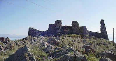 Front view of Berdkunk Fortress
 -
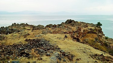 A view of Lake Sevan and Berdkunk Fortress
 -
 Berdkunk Fortress


References[edit]
- ^ a b Statistical Committee of Armenia. "The results of the 2011 Population Census of Armenia" (PDF).
- ^ a b Kiesling, Brady (June 2000). Rediscovering Armenia: An Archaeological/Touristic Gazetteer and Map Set for the Historical Monuments of Armenia (PDF). Archived (PDF) from the original on 6 November 2021.
- ^ a b Bournoutian, George A. (2018). Armenia and Imperial Decline: The Yerevan Province, 1900–1914. Milton Park, Abingdon, Oxon: Routledge. ISBN 978-1-351-06260-2. OCLC 1037283914.
- ^ a b Кавказский календарь на 1910 год [Caucasian calendar for 1910] (in Russian) (65th ed.). Tiflis: Tipografiya kantselyarii Ye.I.V. na Kavkaze, kazenny dom. 1910. Archived from the original on 15 March 2022.
- ^ a b Korkotyan, Zaven (1932). Խորհրդային Հայաստանի բնակչությունը վերջին հարյուրամյակում (1831-1931) [The population of Soviet Armenia in the last century (1831–1931)] (PDF) (in Armenian). Yerevan: Pethrat. Archived from the original (PDF) on 2 February 2022.
- ^ HelpMe.am - Berdkunk (White Fortress)
- ^ a b c Հայաստանի Հանրապետության բնակավայրերի բառարան [Republic of Armenia settlements dictionary] (PDF) (in Armenian). Yerevan: Cadastre Committee of the Republic of Armenia. 2008. Archived from the original (PDF) on 11 March 2018.
External links[edit]
- Report of the results of the 2001 Armenian Census, Statistical Committee of Armenia
- Kiesling, Brady (June 2000). Rediscovering Armenia: An Archaeological/Touristic Gazetteer and Map Set for the Historical Monuments of Armenia (PDF). Archived (PDF) from the original on 6 November 2021.

This article about a location in Gegharkunik Province, Armenia is a stub. You can help Wikipedia by expanding it. |