
Wooroolin, Queensland
| Wooroolin Queensland | |||||||||||||||
|---|---|---|---|---|---|---|---|---|---|---|---|---|---|---|---|
 Grand Hotel, 2008 | |||||||||||||||
 Wooroolin | |||||||||||||||
| Coordinates | 26°24′35″S 151°48′58″E / 26.4097°S 151.8161°E | ||||||||||||||
| Population | 319 (SAL 2021)[1] | ||||||||||||||
| Postcode(s) | 4608 | ||||||||||||||
| Area | 112.1 km2 (43.3 sq mi) | ||||||||||||||
| Time zone | AEST (UTC+10:00) | ||||||||||||||
| Location | |||||||||||||||
| LGA(s) | South Burnett Region | ||||||||||||||
| State electorate(s) | Nanango | ||||||||||||||
| Federal division(s) | Maranoa | ||||||||||||||
| |||||||||||||||
Wooroolin is a rural town and a locality in the South Burnett Region, Queensland, Australia.[2][3]
Geography[edit]
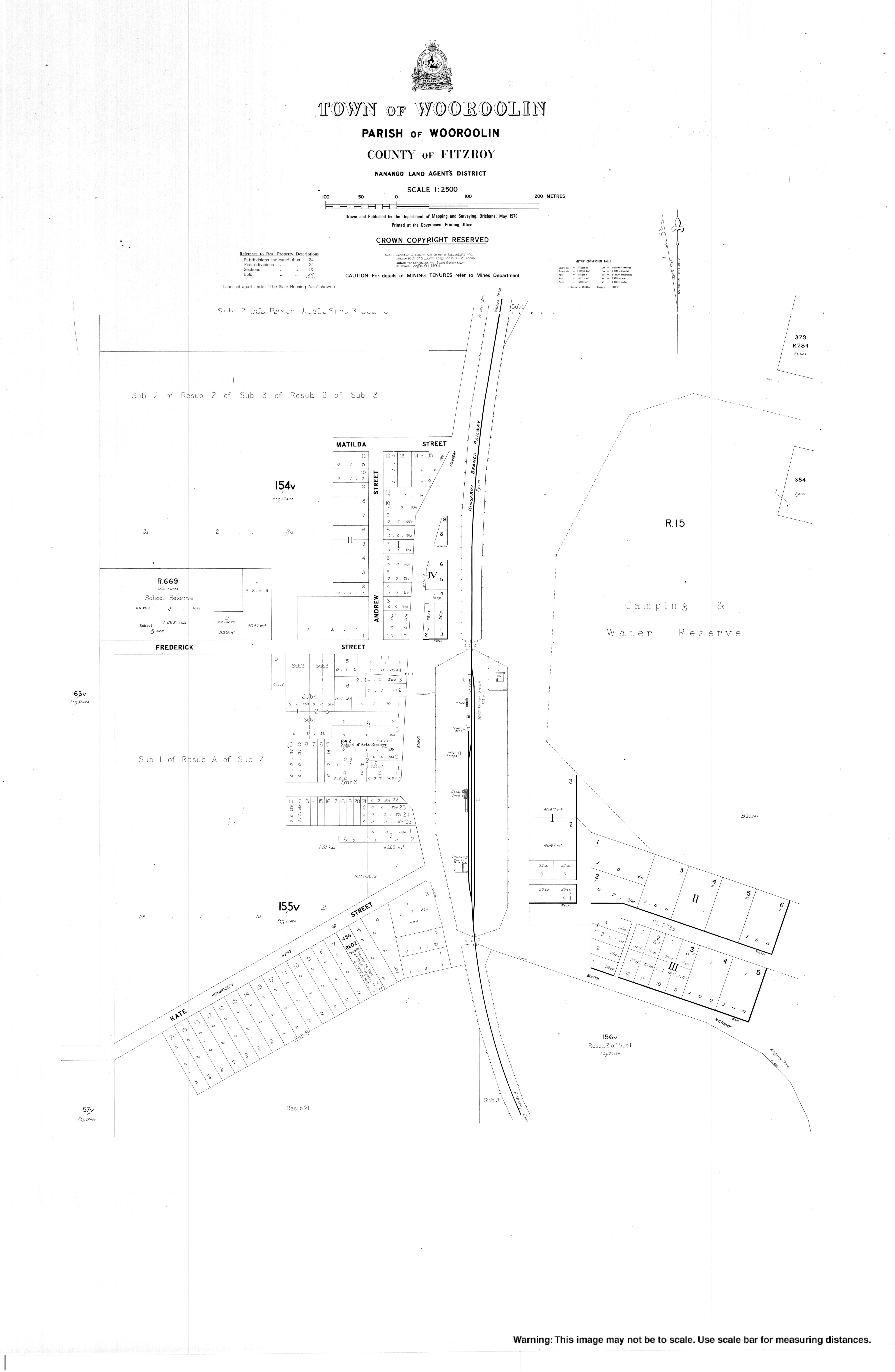
Wooroolin is on the Bunya Highway, 243 kilometres (151 mi) north west of the state capital, Brisbane, and 17 km's North of the main town, Kingaroy.
Immediately to the east of the town is the Wooroolin Wetland, which is classified as a palustrine wetland, a non-tidal, inland, seasonally flooded, vegetated swamp.[4]
History[edit]

Wooroolin Provisional School (also known as Wooroolin Lagoon Provisional School) opened on 18 February 1901 and become Wooroolin State School on 1 January 1909.[5][6][7]
The section of the Nanango railway line from Wondai to Kingaroy opened on 19 December 1904,[8] with Wooroolin served by the Wooroolin railway station (26°24′42″S 151°48′58″E / 26.4118°S 151.8160°E).[9] That section of railway line was closed in 2009.[10] Track removal occurred in 2014 making way for the new Kingaroy-Kilkivan Rail Trail.[11]
Wooroolin Presbyterian Church was opened in 1909 with the first wedding held in the church in December 1909.[12][13] It subsequently closed and has been used as a restaurant. It is at 1 Alexander Street (26°24′49″S 151°48′55″E / 26.4137°S 151.8153°E).[14]
In August 1913, the Catholic community in Wooroolin accepted a tender from B. Robinson to construct a church for £206.[15] On Sunday 9 November 1913, St Patrick's Catholic Church was officially opened by Archbishop James Duhig in the presence of 400 to 500 people, 300 of them came by a special train provided for the occasion. It was 47 by 22 feet (14.3 by 6.7 m) and built from timber in the Gothic style at a cost of £330. It was on a 1-acre (0.40 ha) site on a hill overlooking the town at 24-26 Frederick Street (26°24′33″S 151°48′48″E / 26.40914°S 151.81331°E).[16] It has since been demolished.[17]
St Andrew's Anglican Church was officially opened on Sunday 20 November 1921 by Archdeacon Osborn.[18] It was a timber church capable of seating 50 people.[19] It celebrated its centenary on Sunday 21 November 1921.[20]
Wooroolin West Provisional School opened on 2 April 1929; it closed at some time between 1944 and 1949.[6]
,_1961.webp)
From the late 1950s to the 1970s, the Wooroolin – Tingoora R.S.L. organised an annual Highland Gathering at the Wooroolin sportsgrounds, featuring pipe bands and Scottish highland dance.[21]
At the 2006 census, Wooroolin had a population of 164.[22]
After successive floods in 2011 and 2013, the wetland burst its banks and Wooroolin was flooded for the first time in recorded history.[23] As at 2015, the wetland was still completely full and resembled a large, shallow lake. Due to a bad drought in later years from 2015 to late 2020, the wetlands drained completely. In November 2021, 305 ml of rain fell across the area in and filled up the wetlands in a matter of weeks for the first time in years.[citation needed]
In the 2016 census, Wooroolin had a population of 315 people.[24]
Education[edit]


Wooroolin State School is a government primary (Prep-6) school for boys and girls at 34 Frederick Street (26°24′33″S 151°48′43″E / 26.4091°S 151.8120°E).[25][26] In 2017, the school had an enrolment of 44 students with 5 teachers (3 full-time equivalent) and 7 non-teaching staff (4 full-time equivalent).[27] In 2018, the school had an enrolment of 42 students with 4 teachers (3 full-time equivalent) and 7 non-teaching staff (4 full-time equivalent).[28] The school is known for its school band with bugles and drums, established in 1958. The band regularly performs at Anzac Day ceremonies, agricultural shows, festivals and other community events.[29][30]
There are no secondary schools in Wooroolin. The nearest government secondary schools are Wondai State School (to Year 10) in Wondai to the north-east and Kingaroy State High School (to Year 12) in Kingaroy to the south.[31]
Amenities[edit]
St Andrew's Anglican Church is at 19 Short Street (26°24′41″S 151°48′50″E / 26.411339°S 151.814°E).[19][32]
The Wooroolin branch of the Queensland Country Women's Association meets at Lot 41 Frederick Street.[33]
Notable people[edit]
- Galfry Gatacre CBE DSC DSO (1907–1983), Royal Australian Navy rear admiral and first-class cricketer
References[edit]
- ^ Australian Bureau of Statistics (28 June 2022). "Wooroolin (suburb and locality)". Australian Census 2021 QuickStats. Retrieved 28 June 2022.
- ^ "Wooroolin – town in South Burnett Region (entry 38127)". Queensland Place Names. Queensland Government. Retrieved 28 December 2018.
- ^ "Wooroolin – locality in South Burnett Region (entry 49595)". Queensland Place Names. Queensland Government. Retrieved 28 December 2018.
- ^ "Wooroolin Wetland: Fire and Biodiversity Management Plan (draft)" (PDF). Caroline Haskard Botanical and Natural Systems Services. May 2006. Retrieved 20 October 2009.
- ^ "Opening and closing dates of Queensland Schools". Queensland Government. Retrieved 18 April 2019.
- ^ a b Queensland Family History Society (2010), Queensland schools past and present (Version 1.01 ed.), Queensland Family History Society, ISBN 978-1-921171-26-0
- ^ "History". Wooroolin State School. 5 August 2019. Retrieved 29 October 2022.
- ^ Kerr, John (1990). Triumph of narrow gauge : a history of Queensland Railways. Boolarong Publications. p. 224-225. ISBN 978-0-86439-102-5.
- ^ "Railway stations and sidings - Queensland". Queensland Open Data. Queensland Government. 2 October 2020. Archived from the original on 5 October 2020. Retrieved 5 October 2020.
- ^ Miller, Anne (12 April 2016). "Keith Bids Farewell To Railway Memories". southburnett.com.au. Retrieved 29 October 2022.
- ^ "Kilkivan to Kingaroy Rail Trail". Gympie Regional Council. Retrieved 29 October 2022.
- ^ "Presbyterian Assembly of Queensland". The Brisbane Courier. No. 16, 322. Queensland, Australia. 5 May 1910. p. 5. Retrieved 30 October 2022 – via National Library of Australia.
- ^ "Family Notices". The Brisbane Courier. Vol. LXVI, no. 16, 215. Queensland, Australia. 31 December 1909. p. 7. Retrieved 30 October 2022 – via National Library of Australia.
- ^ Blake, Thom. "Wooroolin Presbyterian Church". Queensland religious places database. Archived from the original on 25 March 2022. Retrieved 25 March 2022.
- ^ "Wooroolin R.C. Church". The Nanango News. No. 708. Queensland, Australia. 8 August 1913. p. 2. Retrieved 30 October 2022 – via National Library of Australia.
- ^ "NEW CHURCH OPENED". The Brisbane Courier. No. 17, 419. Queensland, Australia. 11 November 1913. p. 6. Retrieved 30 October 2022 – via National Library of Australia.
- ^ Blake, Thom. "St Patrick's Catholic Church". Queensland religious places database. Retrieved 22 September 2022.
- ^ "RELIGIOUS". The Brisbane Courier. No. 19, 916. Queensland, Australia. 19 November 1921. p. 8. Retrieved 30 October 2022 – via National Library of Australia.
- ^ a b Blake, Thom. "St Andrew's Anglican Church". Queensland religious places database. Retrieved 22 September 2022.
- ^ "St Andrew's 100 years of church memories". Burnett Today. 18 November 2021. Retrieved 30 October 2022.
- ^ "FROM the VAULT – Help to ID Police Pipe Band members in this photograph". Queensland Police Museum. 17 July 2018. Archived from the original on 27 December 2018. Retrieved 28 December 2018.
- ^ Australian Bureau of Statistics (25 October 2007). "Wooroolin (Kingaroy Shire) (State Suburb)". 2006 Census QuickStats. Retrieved 12 January 2009.
- ^ "Wooroolin Wetland". Discover South Burnett. Retrieved 29 October 2022.
- ^ Australian Bureau of Statistics (27 June 2017). "Wooroolin (SSC)". 2016 Census QuickStats. Retrieved 20 October 2018.
- ^ "State and non-state school details". Queensland Government. 9 July 2018. Archived from the original on 21 November 2018. Retrieved 21 November 2018.
- ^ "Wooroolin State School". Wooroolin State School. 30 July 2019. Retrieved 29 October 2022.
- ^ "ACARA School Profile 2017". Archived from the original on 22 November 2018. Retrieved 22 November 2018.
- ^ "ACARA School Profile 2018". Australian Curriculum, Assessment and Reporting Authority. Retrieved 28 January 2020.
- ^ "Band". Wooroolin State School. 5 August 2019. Retrieved 29 October 2022.
- ^ "TRIBUTE: Wooroolin Bugle Band over the years". Burnett Today. 26 April 2021. Retrieved 29 October 2022.
- ^ "Queensland Globe". State of Queensland. Retrieved 27 December 2018.
- ^ "St Andrew's Anglican Church". Churches Australia. Retrieved 29 October 2022.
- ^ "Branch Locations". Queensland Country Women's Association. Archived from the original on 26 December 2018. Retrieved 26 December 2018.