
Mont-Dore
Mont-Dore | |
|---|---|
 Mont-Dore with the Puy de Sancy in the background | |
.svg) Coat of arms | |
Location of Mont-Dore  | |
 Mont-Dore  Mont-Dore | |
| Coordinates: 45°34′38″N 2°48′35″E / 45.5772°N 2.8097°E | |
| Country | France |
| Region | Auvergne-Rhône-Alpes |
| Department | Puy-de-Dôme |
| Arrondissement | Issoire |
| Canton | Le Sancy |
| Intercommunality | Massif du Sancy |
| Government | |
| • Mayor (2020–2026) | Sébastien Dubourg[1] |
| Area 1 | 35.87 km2 (13.85 sq mi) |
| Population (2021)[2] | 1,237 |
| • Density | 34/km2 (89/sq mi) |
| Time zone | UTC+01:00 (CET) |
| • Summer (DST) | UTC+02:00 (CEST) |
| INSEE/Postal code | 63236 /63240 |
| Elevation | 897–1,883 m (2,943–6,178 ft) (avg. 1,050 m or 3,440 ft) |
| 1 French Land Register data, which excludes lakes, ponds, glaciers > 1 km2 (0.386 sq mi or 247 acres) and river estuaries. | |
Mont-Dore[3] (French pronunciation: [mɔ̃ dɔʁ]; Mont Dòr in Auvergnat, and Mont-Dore-les-Bains), in common usage Le Mont-Dore, is a commune in the Puy-de-Dôme department in Auvergne-Rhône-Alpes in central France.[3]
Geography[edit]
Mont-Dore is located in the Massif Central, on the right bank of the Dordogne not far from its source, and 50 km (31 mi) by road southwest of Clermont-Ferrand. The Monts Dore close the valley towards the south.[4]
Climate[edit]
| Climate data for Le Mont-Dore, 1220m (1991−2020 normals) | |||||||||||||
|---|---|---|---|---|---|---|---|---|---|---|---|---|---|
| Month | Jan | Feb | Mar | Apr | May | Jun | Jul | Aug | Sep | Oct | Nov | Dec | Year |
| Mean daily maximum °C (°F) | 3.6 (38.5) |
3.6 (38.5) |
6.6 (43.9) |
9.5 (49.1) |
13.7 (56.7) |
17.6 (63.7) |
19.9 (67.8) |
20.0 (68.0) |
16.1 (61.0) |
12.3 (54.1) |
6.9 (44.4) |
4.4 (39.9) |
11.2 (52.1) |
| Daily mean °C (°F) | 0.4 (32.7) |
0.2 (32.4) |
3.0 (37.4) |
5.5 (41.9) |
9.4 (48.9) |
12.9 (55.2) |
14.9 (58.8) |
15.1 (59.2) |
11.6 (52.9) |
8.4 (47.1) |
3.7 (38.7) |
1.4 (34.5) |
7.2 (45.0) |
| Mean daily minimum °C (°F) | −2.7 (27.1) |
−3.2 (26.2) |
−0.6 (30.9) |
1.5 (34.7) |
5.0 (41.0) |
8.3 (46.9) |
10.0 (50.0) |
10.1 (50.2) |
7.1 (44.8) |
4.6 (40.3) |
0.5 (32.9) |
−1.7 (28.9) |
3.2 (37.8) |
| Average precipitation mm (inches) | 197.5 (7.78) |
172.2 (6.78) |
174.9 (6.89) |
178.9 (7.04) |
179.8 (7.08) |
147.8 (5.82) |
141.2 (5.56) |
128.8 (5.07) |
155.8 (6.13) |
183.0 (7.20) |
229.4 (9.03) |
240.1 (9.45) |
2,129.4 (83.83) |
| Source: Météo-France[5] | |||||||||||||
Thermal springs[edit]

This section needs to be updated. (March 2022) |
The thermal springs of Mont-Dore, now numbering twelve, were known to the Romans. Sodium bicarbonate, iron and arsenic are the principal ingredients of the waters, which are used both for drinking and bathing. Hot baths are characteristic of the treatment; they are believed to be efficacious for tuberculosis, bronchitis, asthma, and nervous and rheumatic paralysis. Due to the elevation and exposure of the valley, the climate of Mont-Dore is relatively severe, and the season only lasts from 15 June to 15 September. The bath-house was rebuilt in 1891–1894.[4]
Ski resort[edit]
Mont-Dore is a ski resort with runs on the slopes of the Puy de Sancy and the Puy Ferrand. Thirty runs account for 42 km of downhill skiing, served by a number of lifts of different types. There are also 25 km of cross-country trails.
Sights[edit]
In the town park, along the Dordogne, relics of the old Roman baths have been collected. The surrounding country, with its fir woods, pastures, waterfalls and mountains, is very attractive. To the south is the Puy de Sancy (1,886 m), the loftiest peak of central France.[4]
Gallery[edit]
-
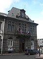 The Hôtel de Ville
 -
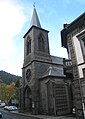 Church
 -
 View from above the Grande Cascade


See also[edit]
References[edit]
- ^ "Répertoire national des élus: les maires" (in French). data.gouv.fr, Plateforme ouverte des données publiques françaises. 13 September 2022.
- ^ "Populations légales 2021". The National Institute of Statistics and Economic Studies. 28 December 2023.
- ^ a b Commune de Mont-Dore (63236), code officiel géographique, INSEE
- ^ a b c Chisholm, Hugh, ed. (1911). . Encyclopædia Britannica. Vol. 18 (11th ed.). Cambridge University Press. p. 763.
- ^ "Fiche Climatologique Statistiques 1991-2020 et records" (PDF) (in French). Météo-France. Retrieved September 10, 2023.
| International | |
|---|---|
| National | |
| Geographic | |
| Other | |
This Puy-de-Dôme geographical article is a stub. You can help Wikipedia by expanding it. |