
Fayet-Ronaye
Fayet-Ronaye | |
|---|---|
 A general view of Fayet-Ronaye | |
Location of Fayet-Ronaye  | |
 Fayet-Ronaye  Fayet-Ronaye | |
| Coordinates: 45°25′34″N 3°32′12″E / 45.4261°N 3.5367°E | |
| Country | France |
| Region | Auvergne-Rhône-Alpes |
| Department | Puy-de-Dôme |
| Arrondissement | Ambert |
| Canton | Les Monts du Livradois |
| Intercommunality | Ambert Livradois Forez |
| Government | |
| • Mayor (2020–2026) | Louis Chauvet[1] |
| Area 1 | 20.25 km2 (7.82 sq mi) |
| Population (2021)[2] | 107 |
| • Density | 5.3/km2 (14/sq mi) |
| Time zone | UTC+01:00 (CET) |
| • Summer (DST) | UTC+02:00 (CEST) |
| INSEE/Postal code | 63158 /63630 |
| Elevation | 823–1,145 m (2,700–3,757 ft) (avg. 1,000 m or 3,300 ft) |
| Website | Association de Fayet-Ronaye[3] |
| 1 French Land Register data, which excludes lakes, ponds, glaciers > 1 km2 (0.386 sq mi or 247 acres) and river estuaries. | |
Fayet-Ronaye is a commune in the Puy-de-Dôme department in Auvergne in central France.

History[edit]
Initially, Ronaye and Fayet were two separate villages, hence the presence of a church in both of them. They used to belong to the family of Grellet de la Deyte in XVIII century. Benoît Grellet de la Deyte was seigneur of Saint-Quentin (in the Somme Department)and of Fayet-Ronaye. Feudal remains (presumably, ruins of the family castle of Grellet de la Deyte) are situated between Frissonet, one of the hamlets of Fayet-Ronaye, and Saint-Germain-l'Herm.
Historical monuments[edit]
Dissard's tumulus[edit]

-
 archeological finds 1901
 -
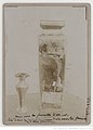
-


According to the researcher Coste ("Supplément au monument druidique de Tuniac"),[4] a burial mound, known as the Dissard's tumulus, located 1 km south away from the center of the village, contained the rests of the druidic chef and his Celtic supporters chased by the army of Marcus Licinius Crassus. The site had been a high place of veneration for the locals.[5] Other researchers argue that the whole legend is a fake.[6]
Cromlech of Frissonnet[edit]
Situated between Fayet and Saint-Germain-l'Herm, the Cromlech of Frissonnet represents a square formed with megalithic standing stones.
Runiac's feudal remains[edit]
The remains are situated near Frissonnet. Jean Olléon presumes it might be the remains of the family castle of Grellet de la Deyte.
See also[edit]
References[edit]
- ^ "Répertoire national des élus: les maires". data.gouv.fr, Plateforme ouverte des données publiques françaises (in French). 2 December 2020.
- ^ "Populations légales 2021". The National Institute of Statistics and Economic Studies. 28 December 2023.
- ^ "Vivre à Fayet-Ronaye". fayetronaye.com, Association locale Vivre à Fayet-Ronaye (in French). 12 December 2021.[permanent dead link]
- ^ Jean Olléon, Mégalithes et traditions religieuses et populaires en Livradois et Forez , Éditions Créer, 1992
- ^ J.-P. Dissard, "Famille Dissard-Cavard" dans Revue héraldique de Rome , 1904
- ^ M. Boudet , "Le prétendu Tuniac" dans Bulletin historique et scientifique de l'Auvergne , 1913, pp.358-379
Jean Olléon, Mégalithes et traditions religieuses et populaires en Livradois et Forez, Éditions Créer, 1992
J.-P. Dissard, "Famille Dissard-Cavard" dans Revue héraldique de Rome, 1904
M. Boudet, "Le prétendu Tuniac" dans Bulletin historique et scientifique de l'Auvergne, 1913, pp. 358–379
External links[edit]
- Local association organizing village festivals, garage sales and publishing a local newspaper "Vivre à Fayet-Ronaye" [permanent dead link]
| Authority control databases: National |
|---|
This Puy-de-Dôme geographical article is a stub. You can help Wikipedia by expanding it. |