
Monbéqui
Monbéqui | |
|---|---|
 | |
.svg) Coat of arms | |
Location of Monbéqui  | |
 Monbéqui  Monbéqui | |
| Coordinates: 43°53′37″N 1°14′26″E / 43.8936°N 1.2406°E | |
| Country | France |
| Region | Occitania |
| Department | Tarn-et-Garonne |
| Arrondissement | Montauban |
| Canton | Montech |
| Intercommunality | Grand Sud Tarn et Garonne |
| Government | |
| • Mayor (2020–2026) | Alfred Marty[1] |
| Area 1 | 6.78 km2 (2.62 sq mi) |
| Population (2021)[2] | 652 |
| • Density | 96/km2 (250/sq mi) |
| Time zone | UTC+01:00 (CET) |
| • Summer (DST) | UTC+02:00 (CEST) |
| INSEE/Postal code | 82114 /82170 |
| Elevation | 88–104 m (289–341 ft) (avg. 97 m or 318 ft) |
| 1 French Land Register data, which excludes lakes, ponds, glaciers > 1 km2 (0.386 sq mi or 247 acres) and river estuaries. | |
Monbéqui (French pronunciation: [mɔ̃beki]; Occitan: Montbequin) is a commune in the Tarn-et-Garonne department in the Occitanie region in southern France.
Monuments[edit]
-
 Town hall
 -
 War monument
 -
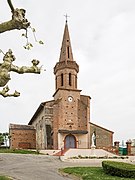 the church


See also[edit]
References[edit]
- ^ "Répertoire national des élus: les maires" (in French). data.gouv.fr, Plateforme ouverte des données publiques françaises. 13 September 2022.
- ^ "Populations légales 2021". The National Institute of Statistics and Economic Studies. 28 December 2023.
Wikimedia Commons has media related to Monbéqui.
This Tarn-et-Garonne geographical article is a stub. You can help Wikipedia by expanding it. |