
Escatalens
Escatalens | |
|---|---|
 | |
.svg) Coat of arms | |
Location of Escatalens  | |
 Escatalens  Escatalens | |
| Coordinates: 43°59′09″N 1°11′23″E / 43.9858°N 1.1897°E | |
| Country | France |
| Region | Occitania |
| Department | Tarn-et-Garonne |
| Arrondissement | Montauban |
| Canton | Beaumont-de-Lomagne |
| Intercommunality | CA Grand Montauban |
| Government | |
| • Mayor (2020–2026) | Michel Cornille[1] |
| Area 1 | 17.99 km2 (6.95 sq mi) |
| Population (2021)[2] | 1,115 |
| • Density | 62/km2 (160/sq mi) |
| Time zone | UTC+01:00 (CET) |
| • Summer (DST) | UTC+02:00 (CEST) |
| INSEE/Postal code | 82052 /82700 |
| Elevation | 75–101 m (246–331 ft) (avg. 88 m or 289 ft) |
| 1 French Land Register data, which excludes lakes, ponds, glaciers > 1 km2 (0.386 sq mi or 247 acres) and river estuaries. | |
Escatalens is a commune in the Tarn-et-Garonne department in the Occitanie region in southern France.
-
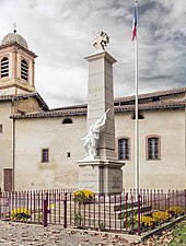 The war memorial
 -
 The church
 -
 The school 'Antoine de Saint-Exupéry'


See also[edit]
References[edit]
- ^ "Répertoire national des élus: les maires" (in French). data.gouv.fr, Plateforme ouverte des données publiques françaises. 13 September 2022.
- ^ "Populations légales 2021". The National Institute of Statistics and Economic Studies. 28 December 2023.
Wikimedia Commons has media related to Escatalens.
| International | |
|---|---|
| National | |
This Tarn-et-Garonne geographical article is a stub. You can help Wikipedia by expanding it. |