Lérouville
Lérouville | |
|---|---|
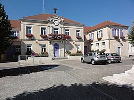
 The town hall in Lérouville | |
| Coordinates: 48°47′33″N 5°32′42″E / 48.7925°N 5.545°E | |
| Country | France |
| Region | Grand Est |
| Department | Meuse |
| Arrondissement | Commercy |
| Canton | Commercy |
| Government | |
| • Mayor (2020–2026) | Alain Vizot[1] |
| Area 1 | 14.38 km2 (5.55 sq mi) |
| Population (2021)[2] | 1,403 |
| • Density | 98/km2 (250/sq mi) |
| Time zone | UTC+01:00 (CET) |
| • Summer (DST) | UTC+02:00 (CEST) |
| INSEE/Postal code | 55288 /55200 |
| Elevation | 225–372 m (738–1,220 ft) (avg. 231 m or 758 ft) |
| 1 French Land Register data, which excludes lakes, ponds, glaciers > 1 km2 (0.386 sq mi or 247 acres) and river estuaries. | |
Lérouville (French pronunciation: [leʁuvil]) is a commune in the Meuse department in Grand Est in north-eastern France. The now-disused Carrière de Lérouville, or Lérouville Quarry, lies just outside the town. Its fifty-ton crane was the subject of a short write-up in the Scientific American Supplement of 12 August 1893.
See also[edit]
References[edit]
- ^ "Répertoire national des élus: les maires". data.gouv.fr, Plateforme ouverte des données publiques françaises (in French). 2 December 2020.
- ^ "Populations légales 2021". The National Institute of Statistics and Economic Studies. 28 December 2023.
Wikimedia Commons has media related to Lérouville.


