
Foucaucourt-sur-Thabas
Foucaucourt-sur-Thabas | |
|---|---|
 The town hall in Foucaucourt-sur-Thabas | |
.svg) Coat of arms | |
Location of Foucaucourt-sur-Thabas  | |
 Foucaucourt-sur-Thabas  Foucaucourt-sur-Thabas | |
| Coordinates: 48°59′59″N 5°06′06″E / 48.9997°N 5.1017°E | |
| Country | France |
| Region | Grand Est |
| Department | Meuse |
| Arrondissement | Bar-le-Duc |
| Canton | Dieue-sur-Meuse |
| Intercommunality | CC de l'Aire à l'Argonne |
| Government | |
| • Mayor (2020–2026) | Clarisse Jacquet[1] |
| Area 1 | 9.92 km2 (3.83 sq mi) |
| Population (2021)[2] | 61 |
| • Density | 6.1/km2 (16/sq mi) |
| Time zone | UTC+01:00 (CET) |
| • Summer (DST) | UTC+02:00 (CEST) |
| INSEE/Postal code | 55194 /55250 |
| Elevation | 175–231 m (574–758 ft) (avg. 124 m or 407 ft) |
| 1 French Land Register data, which excludes lakes, ponds, glaciers > 1 km2 (0.386 sq mi or 247 acres) and river estuaries. | |
Foucaucourt-sur-Thabas is a village and a commune in the Argonne region in the Meuse department in Grand Est in north-eastern France.
It is the only village in the commune.
The nearest town is Sainte-Menehould, 'capital' of the Argonne, some 27 km to the northeast.
See also[edit]
-
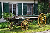 Old cart in the village
 -
 Parish Church of St. John the Baptist
 -
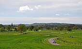 Approaching Foucaucourt
.JPG)
.JPG)
.JPG)
-
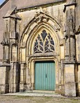 Church entrance
 -
 WW-I memorial
.JPG)
.JPG)
References[edit]
- ^ "Répertoire national des élus: les maires". data.gouv.fr, Plateforme ouverte des données publiques françaises (in French). 9 August 2021.
- ^ "Populations légales 2021". The National Institute of Statistics and Economic Studies. 28 December 2023.
Wikimedia Commons has media related to Foucaucourt-sur-Thabas.
| Authority control databases: National |
|---|
This Meuse geographical article is a stub. You can help Wikipedia by expanding it. |