
Kuitaart
Kuitaart | |
|---|---|
Village | |
 Village view | |
 Kuitaart Location in the province of Zeeland in the Netherlands  Kuitaart Kuitaart (Netherlands) | |
| Coordinates: 51°20′23″N 4°2′3″E / 51.33972°N 4.03417°E | |
| Country | Netherlands |
| Province | Zeeland |
| Municipality | Hulst |
| Area | |
| • Total | 5.59 km2 (2.16 sq mi) |
| Elevation | 0.4 m (1.3 ft) |
| Population (2021)[1] | |
| • Total | 225 |
| • Density | 40/km2 (100/sq mi) |
| Time zone | UTC+1 (CET) |
| • Summer (DST) | UTC+2 (CEST) |
| Postal code | 4584[1] |
| Dialing code | 0114 |
Kuitaart is a village in the Dutch province of Zeeland. It is a part of the municipality of Hulst, and lies about 24 km southwest of Bergen op Zoom.
The village was first mentioned in 1469 as up Coytaerde. The etymology is unknown.[3]
The grist mill Vogelzicht was built in 1865. In 1904, an engine was installed in the mill. The wind mill was restored in 2004.[4]
Kuitaart was home to 197 people in 1840. The village used to be part of the municipality of Hontenisse. In 2002, it became part of the municipality of Hulst.[4]
Gallery[edit]
-
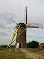 Wind mill Vogelzicht
 -
 Villa Lettenburg


References[edit]
- ^ a b c "Kerncijfers wijken en buurten 2021". Central Bureau of Statistics. Retrieved 20 April 2022.
- ^ "Postcodetool for 4584LG". Actueel Hoogtebestand Nederland (in Dutch). Het Waterschapshuis. Retrieved 20 April 2022.
- ^ "Kuitaart - (geografische naam)". Etymologiebank (in Dutch). Retrieved 20 April 2022.
- ^ a b "Kuitaart". Plaatsengids (in Dutch). Retrieved 20 April 2022.
This article about a location in Zeeland is a stub. You can help Wikipedia by expanding it. |