
User:Telecineguy/sandbox

++++++++++++++ <be>
https://wikipedialibrary.wmflabs.org/terms/
[refil]
Notes
{ { efn } } Notes =
{ {attribution|nolink=Aeronautical Digest Publishing Corp|text=Reproduced from Aero Digest Magazine Vol.15 No.4 October, 1929} }
Picture link Flying Scotsman

http://area23.brightbyte.de/csv2wp.php excel to wiki table. https://excel2wiki.toolforge.org/index.php excel to wiki table.
Uk gov before 1 June 1957 Australia all before 1 January 1955 Cananda ALl before 1 January 1949
Ship types: 1944
https://www.history.navy.mil/research/library/online-reading-room/title-list-alphabetically/m/merchant-ship-shapes.html
Russian space stations[edit]
The Russian Soviet Union was active in planing and building Russian space stations/Soviet space stations. Many of the Soviet proposals and designs did not get built, but did helped in future Soviet space stations. Below is a list of proposals, designs and launches of Soviet space stations. Soviet Union proposals for a space stations started in 1960, just three years after the launch of Sputnik 1 in 1957 and continued till the dissolution of the Soviet Union in 1991. Some of the Soviet designed continued into the Independent Russian Federation and the International Space Station.[1][2]
==Soviet space stations==
==OS==
OS (Orbital Station ) was the first plan for a Soviet manned space station. The Soviet study started in 1960. In 1960, Sergei Korolev, lead Soviet rocket engineer and spacecraft designer, proposed a military space station. His proposal had a crew of 3 to 5 cosmonauts in orbit at an altitude 350 to 400 km above Earth. The proposal was for a 30,000 kilograms (66,000 lb) space station. Korolev did not get approved for his design, but some parts of this plans were put into the TKS station plans. [3]
==TKS heavy space station - TOSZ==
TKS heavy space station, also called TOSZ, was a Korolev proposal for manned space station started in 1961. As the new powerful N1 rocket was being developed, Korolev now had hope of a super heavy-lift launch vehicle able to place a large space military station into orbit. TKS heavy space station plans called for a gross mass of 150,000 kilograms (330,000 lb), a height of 52 metres (171 ft), and a diameter of 4.5 metres (15 ft). The TKS Heavy Space Station was to use two to three 50,000 kilograms (110,000 lb) station modules launched on some of the first N1 rocket launches. New crewmembers would be put on the TKS heavy space station each month. At the time the civilian Sever spacecraft designed around the early plans of the Soyuz Spacecraft would be used for the ferry craft to the TKS. Space docking ports would be built into the spacecraft and TKS station. TKS power was from solar arrays, as each following space station plan would have. Korolev's draft was submitted on 3 May 1961, it was not accepted, but Korolev continued his desire for a space station. [4]
==OS-1962 space station==
The OS-1962 space station was part of the Sever project. OS-1962, Orbital Station 1962, was a Korolev proposal that was approved on 10 March 1962 and called the "Complex docking of spacecraft in earth orbit - Soyuz". The OS-1962 space station was to have a gross mass of 13,000 kilograms (29,000 lb). In the first plan, the ferry spacecraft would have been two times the size of the final design, the Soyuz spacecraft. The space station was to be launched by three R-7 rocket launches and a use a Vostok-7 spacecraft. The plan was for an earth observation platform. The OS-1962 space station would have ZhO living section, a BAA scientific apparatus block, and the Sever (Soyuz) spacecraft docked to the space station. While OS-1962 was not built some of its designs were used in later space stations.[5][6]
==OP space station==
OP space station (Orbitalniy Poyas or OP -Orbital Belt), was a 1962 Korolev proposal for a 50,000 kilograms (110,000 lb) military space station. The OP military space station would also control geosynchronous nuclear-powered communication satellites. Korolev proposal was submitted 20 April 1962. The plan also had maneuverable attack satellites to attack United States satellites that would orbit in altitudes from 300 to 2,000 km. The OP space station would also have anti-ballistic missile interceptors in altitudes from 150 to 100 km. The Soviet military did not approve the Korolev OP space station plans.[7]
==OS-1==
The OS-1 was a 1965 Soviet space station design. This was the is first Soviet space station design to make it to the mock-up stage of design, thus was a major milestone of Soviet space station design. The OS-1 was to have a mass of 75,000 kilograms (165,000 lb) and height of 25 metres (82 ft). The OS-1 was approved by Nikita Khrushchev after a meeting of space engineers at Pitsunda. Khrushchev wanted a manned space station with nuclear weapons in low Earth orbit placed in space with the N1 rocket. The mock-up construction started on 25 September 1962 and was completed in 1965. While OS-1 was not built some of its designs were used in later space stations. [8]
==Soyuz R==
Soyuz R Russian manned spacecraft. A military reconnaissance version of Soyuz, developed by Kozlov at Samara from 1963-1966. It was to consist of an the 11F71 small orbital station and the 11F72 Soyuz 7K-TK manned ferry. Soyuz R was cancelled in 1966. [9]
==Soyuz-VI==
Soyuz-VI military space station plan at first built on the Soyuz 7K-OK spacecraft. After a number of failure of the Soyuz 7K-OK in November 1966, Kozlov started as new design of the Soyuz-VI. The new Soyuz-VI has a crew of two, a mass of 6.600 kilograms (14.55 lb) and would be received once a month. The new plan was approved on 21 July 1967, testing to start in 1968 and operational in 1969. The station was to have a Aleksandr Nudelman recoilless gun. On plan was to have Soyuz-VI be able to dock with the planned Almaz space station. So the space station did not have to face the Sun all the time, for power the plan was for two Radioisotope thermoelectric generator (RTG). In 1967 a Soyuz-VI mock-up was completed and recoilless gun dynamic stand was completed at Samara. In September 1966 the cosmonauts for the project were picked: Pavel Popovich, Alexei Gubarev, Yuri Artyukhin, Vladimir Gulyaev, Boris Belousov, and Gennadiy Kolesnikov. In 1968 the crew was reduced to Gubarev and Zaikin. After conflict, on 8 December 1967, Vasily Mishin took control of the Soyuz-VI project. Mishin later had Soyuz-VI cancelled in 1969. Some part of Soyuz-VI were placed in the Soyuz 7K-S and later units of Soyuz T and Soyuz TM.[10]
==OS-1-1969===
OS-1-1969 was a 1969 plan for a very large OS-1 space station. OS-1-1969 was planned to be 75,000 kilograms (165,000 lb) and 25 metres (82 ft) tall, with a crew of six. A OS-1-1969 mock-up was built, the OS-1-1969 would have need the powerful N1 rocket for launching. OS-1-1969 projected ended at the end of the N1 launch vehicle program in 1974. [11]
==MKBS==
MKBS manned multipurpose space base station plan started in 1966. The very large MKBS space station would have had a mass of 250,000 kilograms (550,000 lb) and 100 metres (330 ft) tall. Vasily Mishin design was to have the space station built in block including communications station and special space weapons block. The Big Orbital Station (BOS) with a space for a crew of 9 to 12 cosmonauts was competing plan. MKBS and BOS would have need the powerful N1 rocket for launching. MKBS projected ended at the end of the N1 launch vehicle program in 1974. [12]
==37K-Mir==
37K-Mir was a plan for a manned space station that was cancelled 1983 and the Salyut design was approved and built. The 37K-Mir 1979 design was for a station of mass of 20,000 kilograms (44,000 lb) and 4.2 metres (14 ft)diameter with on docking port. The station had no propulsion system and would use a space tug to move. [13]
==Salyut 1==
Salyut 1 (DOS-1) was the first space station the Soviet's launched the space station into low Earth orbit on April 19, 1971. Salyut 1 used a modified Almaz craft for Salyut 1. The three cosmonauts of Soyuz 11 were aboard Salyut 1 for 23 days, the start of the Salyut programme. The three cosmonauts died during Earth's reentry in their Soyuz capsule. With the end of the Soviet's moon program the Soviet Union put an increse into the space station program.[14][15]
==Almaz==
Almaz OPS (Diamond) secret Soviet military space station program started in 1965 and designed by Vladimir Chelomei. Almaz was the only manned military spacecraft to have been launched from 1973 to 1977, as Salyut 2, Salyut 3 and Salyut 5. Three Soyuz crews successfully visited two test Almaz stations. The flights had an array of sensors for the cosmonaut observations.
[16][17]
==Salyut 2==
Salyut 2 launched in 1973 and was to be the first Almaz military space station. Before any crew could visit the station it lost altitude control, depressurized and re-entered on 28 May 1973.[18]
==Salyut 3==
Salyut 3 was of the Almaz design, the second. the Soviet space station was launched on 25 June 1974. Called Salyut to cover up is military operations. One crew successfully boarded and operated the station, Soyuz 14. Soyuz 15 was unable to dock and the mission was aborted. [19]
==Salyut 4==
Salyut 4 was launched in 1973, the Soviet civilian space station was based on the Almaz military station, the four of the DOS-1 design. Salyut 4 had a mass: 18,210 kilograms (40,150 lb), and 13.07 metres (42.9 ft) tall and solar array span of 17.07 metres (56.0 ft). [20]
==Salyut 5==
Salyut 5 was the last Almaz design space station used. Salyut 5 military station launched in 1976. Two Soyuz crew visited the space station each with two cosmonauts, Soyuz 21 launched on 6 July 1976 and Soyuz 24 launched on 7 February 1977. Soyuz 23 was not able to dock and the mission was aborted.
==Salyut 6==
Salyut 6 was launched on 29 September 1977. Salyut 6 had two docking ports and a BST-1M multispectral telescope. Salyut 6 was the first space station have long term missions and have uncrewed spacecraft resupply the station. The crews of Soyuz 25, Soyuz 26, Soyuz 27, Soyuz 28, Soyuz 29, Soyuz 30, Soyuz 31, Soyuz 32, [[Soyuz 34, Soyuz T-1 (repair team), Soyuz 35, Soyuz 36, Soyuz T-2, Soyuz 37, Soyuz 38, Soyuz T-3, Soyuz T-4, Soyuz 39, and Soyuz 40. Progress 1 was the first of 12 uncrewed spacecraft to resupply the space station. Soyuz 33 failed to dock and the mission was aborted. Kosmos 1267, an unmanned TKS spacecraft, docked to Salyut 6.[21][22][23]
==Salyut 7==
Salyut 7 was launch 19 April 1982, the space station was placed in low Earth orbit. Soyuz T-5 was the first crew on Salyut 7. Salyut 7 was visited by 12 crewed spacecraft and 15 uncrewed spacecraft. These spacecraft included the Soyuz T, Progress supplies, and TKS spacecraft. Some of the missions to Salyut 7 included: Soyuz T-5, Soyuz T-6, Soyuz T-7, Soyuz T-8, Soyuz T-9, Soyuz T-10, Soyuz T-11 , Soyuz T-12, Soyuz T-13, Kosmos 1686, Soyuz T-14, and Soyuz T-15. Soyuz T-15 the last Salyut 7 visit in June 1986, also docked with Mir on 15 March 1986. Soyuz 7K-ST No.16L failed to launch to Salyut 7. The film Salyut 7 was made about the repair work done on Salyut 7. Salyut 7 was 16 metres (52 ft) long and 4.15 metres (13.6 ft) in diameter, with a mass of 19,824 kilograms (43,704 lb).[24][25]
==Mir==
Mir was the first modular space station assembled in orbit. The first module was launched on 20 February 1986. The next modules were module on, 31 March 1987, 26 November 1989, 31 May 1990, 20 May 1995, 15 November 1995, and 26 April 1996. The 15 November 1995 module was brought up by The US Space Shuttle Atlantis (STS-74). Mir was in low Earth orbit from 1986 to 2001, starting with the Soviet space project and ending in the Russia space program. Mir conducted experiments in biology, human biology, physics, astronomy, meteorology, and long time spacecraft living.[26][27]
==37KS==
The 37KS was plans for a manned Mir space station modules that was cancelled in 1983. The plans called each module to have a mass of 20,000 kilograms (44,000 lb), and 4.27 metres (14.0 ft) diameter. Four 37KS modules were planned for Mir.[28]
==LO==
LO plans was part of the 37K plan, but the 1984 LO space station plan had the space station be launched in the bay of the Buran spacecraft. LO was to have civilian experiments in the LO Laboratory Compartment. The LO module to have a mass of 7,150 kilograms (15,760 lb), height of 5.1 metres (17 ft), habitable volume of 37 3m[convert: unknown unit], and a 4.2 metres (14 ft) diameter. Buran made test flights but was not put in operations. LO would have been similar to the STS-9 mission. [29]
==NPG==
NPG was part of the 37K/LO manned space station project that was cancelled in 1986. NPG was the designed for use with military experiments in the bay of the Buran spacecraft. The LO module to have a mass of 7,150 kilograms (15,760 lb), height of 5.1 metres (17 ft), habitable volume of 37 3m[convert: unknown unit], and a 4.2 metres (14 ft) diameter. Buran made test flights but was not put in operations. [30]
==37KB==
The 37KB was a manned space station module planned for the first Buran flight to Mir. The 37KB module was similar to the Kvant module on Mir space station. The 37KB module had construction started but was ended when Buran project was ended in 1993. [31]
==Mir-2==
Mir-2 project was started in February 1976. While Mir-2 was never launched as planned, some of the modules built for Mir-2 were used in the International Space Station (ISS). The core of Mir-2 in the planning was the DOS-8 base block space station core module. The DOS-8 was built as the back-up module for Mir, the DOS-7 base block. This DOS-8 base block became the Zvezda module launched on 12 July 2000 and docked to ISS on 26 July 2000.[32] [33][34][35]
==Mir-2 KB Salyut==
Mir-2 KB Salyut was a planned manned space station that was cancelled in 1988. Mir-2 KB Salyut was an alternative design of the Mir-2 space station. The Mir-2 KB Salyut was to used the Buran and the planned Polyus spacecraft, a space weapon, for ferry flights.[36]
==International Space StationISS==
Russian built a number of modules used on the International Space Station (ISS) called the Russian Orbital Segment:
- Zarya (dawn)
- Zvezda (star)
- Poisk (search)
- Rassvet (sunrise, dawn)
- Nauka (science)
- Prichal (berth)
- Pirs (ISS module) (decommissioned)
==Orbital Piloted Assembly and Experiment Complex==
Orbital Piloted Assembly and Experiment Complex was 2009–2017 proposed third-generation Russian modular space station. Project was cancelled in 2017.
==Russian Orbital Service Station==
- Russian Orbital Service Station is a plan for a new space station scheduled to begin construction in 2027.
==See also==
== References ==
- ^ http://www.astronautix.com/s/sovietspacestations.html
- ^ Henry Spencer (2 November 2010). "High life: a short history of the space station". New Scientist. Retrieved 12 February 2011.
- ^ http://www.astronautix.com/o/os.html
- ^ http://www.astronautix.com/t/tksheavyspacestation.html
- ^ "OS-1962". www.astronautix.com.
- ^ "Vostok-Zh". www.astronautix.com.
- ^ http://www.astronautix.com/o/op.html
- ^ http://www.astronautix.com/o/os-11965.html
- ^ http://www.astronautix.com/s/soyuzr.html
- ^ http://www.astronautix.com/s/soyuzvi.html
- ^ http://www.astronautix.com/o/os-11969.html
- ^ http://www.astronautix.com/m/mkbs.html
- ^ http://www.astronautix.com/3/37k-mir.html
- ^ "Salyut 1". NSSDC ID: 1971-032A. NASA. Retrieved 24 March 2012.
- ^ http://www.astronautix.com/s/salyut1.html
- ^ www.astronautix.com/a/almazops.html
- ^ http://www.astronautix.com/a/almaz.html
- ^ "Salyut 2". United States National Space Data Center. 8 October 2010. Retrieved 4 January 2010.
- ^ "Salyut 3 - NSSDC ID: 1974-046A". NASA.
- ^ http://www.astronautix.com/s/salyut4.html
- ^ Cite error: The named reference
SSSMwas invoked but never defined (see the help page). - ^ "NASA – NSSDC – Spacecraft – Details". NASA. 2 April 2008. Retrieved 29 June 2008.
- ^ http://www.astronautix.com/s/salyut6.html
- ^ David Portree – Mir Hardware Heritage (1995) – Page 90-95 – NASA RP1357
- ^ http://www.astronautix.com/s/salyut7.html
- ^ Jackman, Frank (29 October 2010). "ISS Passing Old Russian Mir In Crewed Time". Aviation Week.[permanent dead link]
- ^ http://www.astronautix.com/s/spektr.html
- ^ http://www.astronautix.com/3/37ks.html
- ^ http://www.astronautix.com/l/lo.html
- ^ http://www.astronautix.com/n/npg.html
- ^ http://www.astronautix.com/3/37kb.html
- ^ "Mir-2". Astronautix. Archived from the original on 20 August 2016. Retrieved 12 February 2011.
- ^ Anatoly Zak. "International Space Station - MIR-2: Russian roots of the ISS program (1969-1992)". Russian Space Web. Retrieved 12 February 2011.
- ^ "ISS Elements: Service Module ("Zvezda")". SpaceRef.com. Retrieved 12 February 2011.
- ^ http://www.astronautix.com/m/mir-2.html
- ^ http://www.astronautix.com/m/mir-2kbsalyut.html
== External links ==
- RSC Energia: Concept Of Russian Manned Space Navigation Development
- David S.F. Portree, Mir Hardware Heritage, NASA RP-1357, 1995
- Information on Soyuz spacecraft
- NASA - Russian Soyuz TMA Spacecraft Details
| Current |  | ||||||||
|---|---|---|---|---|---|---|---|---|---|
| Past |
| ||||||||
| Canceled |
| ||||||||
| In development |
| ||||||||
| Proposed | |||||||||
| Concepts | |||||||||
| Related |
| ||||||||
Notes: † Never inhabited due to launch or on-orbit failure, ‡ Part of the Almaz military program, ° Never inhabited, lacks docking mechanism. | |||||||||
| Salyut stations (DOS) |  | |
|---|---|---|
| Almaz stations (OPS) |
| |
| Successors | ||
| TKS spacecraft | ||
| Support craft | ||
| Lists |
| |
| Related |
| |
| Current | | ||||||||
|---|---|---|---|---|---|---|---|---|---|
| Past |
| ||||||||
| Canceled |
| ||||||||
| In development |
| ||||||||
| Proposed | |||||||||
| Concepts | |||||||||
| Related |
| ||||||||
Notes: † Never inhabited due to launch or on-orbit failure, ‡ Part of the Almaz military program, ° Never inhabited, lacks docking mechanism. | |||||||||
Components of Mir | ||
|---|---|---|
| Soviet modules |  | |
| Russian/American modules | ||
| Other subsystems | ||
| Visiting spacecraft | ||
| Other articles | ||
| Related lists | ||
| 1986–1990 |  | |
|---|---|---|
| 1991–1995 | ||
| 1996–2000 | ||
| Spacecraft |  | |
|---|---|---|
| Missions | ||
| Increments | ||
| Launch sites | |||||||||
|---|---|---|---|---|---|---|---|---|---|
| Launch vehicles | |||||||||
| Human spaceflight programs |
| ||||||||
| Robotic programs |
| ||||||||
| Communications | |||||||||
| Concepts | |||||||||
| Images and artwork | |||||||||
| Related | |||||||||
| Main topics |  | ||||||||||||||||||||||||||
|---|---|---|---|---|---|---|---|---|---|---|---|---|---|---|---|---|---|---|---|---|---|---|---|---|---|---|---|
| Past missions (by spacecraft type) |
| ||||||||||||||||||||||||||
| Current missions | |||||||||||||||||||||||||||
| Future missions |
| ||||||||||||||||||||||||||
Uncrewed missions are designated as Kosmos instead of Soyuz; exceptions are noted "(uncrewed)". The † sign designates failed missions. Italics designates cancelled missions. | |||||||||||||||||||||||||||
Category:Crewed spacecraft Category:Soyuz program
+++++++++++
Notes[edit]
- Carbon Dioxide habitable zone is the place the planets will have the correct levels of carbon dioxide. The range for carbon dioxide levels is very narrow for life. The gas, Carbon dioxide, is essential for life. Life forms use carbon dioxide to regulate respiration and control blood pH. Plants use carbon dioxide to create oxygen through photosynthesis. High carbon dioxide levels causes hypercapnia.[1]
"A limited habitable zone for complex life." The Astrophysical Journal 878.1 (2019): 19. [2]
Table 1: Most Promising “Category 1” HZ Candidates from Kane et al.
Name Period (days) Orbit Radius (AU) Planet Radius (Earth=1) Stellar Flux (Earth=1)
Kepler 62f 267.3 0.718 1.41±0.07 0.42±0.05
Kepler 186f 129.9 0.432 1.17±0.08 0.26±0.04
Kepler 442b 112.3 0.409 1.34±0.14 0.73±0.11
Kepler 1229b 86.8 0.290 1.25±0.21 0.37±0.11
Kepler 1512b 20.4 0.129 0.61±0.13 0.87±0.38
S-IC-T[edit]
.jpg)
==POSEIDON BARGE-YFNB-40==
POSEIDON BARGE, HULL# YFNB-40, VESSEL LENGTH: 265, VESSEL BEAM: 52, VESSEL DRAFT: 3, ENGINE TYPE: DIESEL, ASBESTO TYPE: NON-FRIABLE, COAST GUARD INSPECTED: YES, THIS VESSEL WAS BUILT FOR THE NAVY IN 1945 AS A WORK BARGE. IT WAS CONVERTED FOR NASA SERVICE (APOLLO PROGRAM) AND DESIGNATED AS POSEIDON BY AVONDALE SHIPYARDS INC IN 1966. THE VESSEL PLAYED A SIGNIFICANT ROLE IN TRANSPORTING THE SPACE SHUTTLE EXTERNAL TANKS AND WAS EVALUATED IN 2007 AS ELIGIBLE FOR LISTING ON THE NATIONAL REGISTER FOR ITS SIGNIFICANCE TO THE SPACE SHUTTLE PROGRAM. THE VESSEL HAS A COVERED DECK AND IS IN FAIR CONDITION FOR TRANSIT. THE LAST DRY DOCK WAS APPROXIMATELY 2000. HULL TO MAIN DECK WAS PAINTED, SOME SIDE SHELL AND BOTTOM PLATE WAS REPAIRED AND REPLACED. CORROSION PREVENTATIVE FILMS/GELS WERE APPLIED IN THE BALLAST TANKS, AND SEA VALVES WERE SERVICED IN 1997 DRY DOCK. THERE IS COMMUNICATION AMONG THE BALLAST TANKS, INDICATING WASTAGE BETWEEN SOME WATER TIGHT BULKHEADS. TOW BRIDAL INCLUDED AT BOW CONSTRUCTED IN A Y-BRIDAL CONFIGURATION MADE FROM THREE LENGTHS OF CHAIN AND A TOWING PLATE. TOW PENDANT APPROXIMATELY 20 FEET IN LENGTH. CHAIN BRIDLES APPRXIMATLEY 55 FEET IN LENGTH. THOUGH IN DIFFERING STATES OF FUNCTIONALITY ALL MECHANICAL SYSTEMS ARE INTACT INCLUDING TWO BALLAST PUMPS/ MOTORS. ANCHOR WINDLESS/ANCHOR/ANCHOR CHAIN. POTABLE WATER PUMP/MOTOR/ACCUMULATOR, SANITARY SYSTEM, A/C SYSTEM, LARGE GALLEY EQUIPMENT, WASHIER/DRYER, AND MSD. MOST OF THESE SYSTEMS WERE REPLACED OR MODIFIED IN 1980~S AND 1990~S. TYPES OF ENGINES: ONE PAIR MODEL 8-71V/150KW DETROIT DIESEL PRIME POWER GENERATOR SET. THE PORT SET IS AIR START AND THE STARBOARD SET IS ELECTRIC START. GENERATOR PARTICULARS: DELCO MODEL E-5227M4, 1800 RPM, 150KW, 60HZ, 440VAC, 3 PHASE SWITCHBOARD PARTICULARS: NON-PARALLEL, TWO 3 POLE, 150 AMP, 3 PHASE PULL OUT TYPE CIRCUIT BREAKERS. A 3 POLE, 100 AMP, 3 PHASE PULL OUT TYPE CIRCUIT BREAKER FOR SHORE POWER. HOURS ON ENGINE ARE UNKNOWN BUT WERE HAULED IN 1990
==nasas-barge-pegasus==
NASA’s Barge Pegasus – Transportation for the Space Launch System Core Stage Download PDF
Barge Pegasus Facts
Length: 310 feet (94.4 meters) Width: 50 feet (15.24 meters) Usable cargo deck length: 240 feet (73.15 meters) Usable cargo deck width: 36 feet (10.97 meters) Usable cargo deck height: 41 feet (12.49 meters) On-Board Power: Three 200 kilowatt generators Engines: None. Tugboats or towing vessels are required to move the barge. The 212-foot-tall, 27.6-foot-diameter core stage includes the cryogenic liquid hydrogen and liquid oxygen tanks that will feed four RS-25 rocket engines, and also contains the vehicle’s avionics and flight computer. The SLS core stage will be the longest item ever shipped by a NASA barge.
NASA has for decades used barges to move its large spaceflight structures. Pegasus was specially designed and built in 1999 to transport the giant external tanks of the space shuttles from the Louisiana shore to NASA’s Kennedy Space Center on the eastern coast of Florida – a 900-mile journey that includes both inland and open-ocean waterways. Pegasus replaced Poseidon and Orion, barges that were used to carry Saturn rocket stages and hardware for the Apollo Program. Pegasus completed its final space shuttle-related voyage in 2011.
https://www.nasa.gov/reference/nasas-barge-pegasus/
.jpg) S-IC-T being lifted into the B-2 Test Stand | |
| Manufacturer | Boeing for NASA |
|---|---|
| Country of origin | United States |
| Used on | Static testing of the S-IC stage, used on the Saturn V rocket program |
| General characteristics | |
| Height | 42 m (138 ft) |
| Diameter | 10 m (33 ft) |
| Gross mass | 5,030,000 lb (2,280,000 kg) |
| Propellant mass | 4,400,000 lb (2,000,000 kg) |
| Empty mass | 290,000 lb (130,000 kg) |
| Launch history | |
| Status | Display at Kennedy Space Center |
| Total launches | None, static test stage at NASA Mississippi Test Facility, now known as Stennis Space Center |
| Successes (stage only) | 18 test fires from 1965 to 1967 |
| Engine details | |
| Powered by | 5 F-1 |
| Maximum thrust | 34,500 kN (7,750,000 lbf) sea level[3] |
| Specific impulse | 263 seconds (2.58 km/s) |
| Burn time | 150 s |
| Propellant | RP-1/LOX |

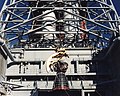
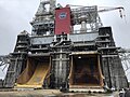
S-IC-T is a Saturn V first stage, S-IC, of a the three stage rocket. S-IC-T was built by Boeing Company, under contact from National Aeronautics and Space Administration, to be a static test rocket. The main role of the S-IC-T was the testing of the five liquid fuel rocket engines to be used in the Apollo program. S-IC-T static test fired the rockets at NASA Mississippi Test Facility, now known as Stennis Space Center. S-IC-T was assembled at the Marshall Space Flight Center in Huntsville, Alabama. S-IC-T was given the nickname T-Bird (Test Bird). The first burn test was on April 10, 1965. S-IC-T-Saturn V is a Super heavy-lift launch vehicle. S-IC-is is on display at Kennedy Space Center in Florida. [4][5]
==History==
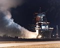
Before S-IC-T, the first complete S-IC stage built, Boeing built prototype stages: SA-500F and SA-500D. These were used for testing the new S-IC first stage. Boeing Company was awarded the contract to build S-IC-T on March 6, 1963 from NASA. [6] The S-IC-T was test fired at a newly build test firing facility, called the B-2 Test Stand (S-IC-T stage), in the west test area. B-2 Test Stand is now part of the Stennis Space Center. S-IC-T was planned as test rocket only and not to be used in the later Apollo program. The Saturn V rocket was used in the Apollo program to depart Earth's gravity. S-IC-T, like all following Saturn V's S-IC rockets used five Rocketdyne F-1 engines. The Rocketdyne F-1 engine was first tested in March 1959 and delivered to NASA in October 1963. S-IC-T was built starting in 1963 and complete in 1965. The S-IC-T tests were to verify that the S-IC stage could support the firing of all five Rocketdyne F-1 engines at the same time. The testing was also a test of the two large fuel tanks. The five Rocketdyne F-1 engines produced 34,500 kN (7,750,000 lbf) of thrust, the first burn of the most powerful rocket ever. The powerful rockets caused ground shaking and smoke filled the area from the engine flames. Thus, B-2 Test Stand earned the the nickname the land of the earth shakers.[7][8]
A crane was used to install S-IC-T into the B-2 Test Stand. Then the five F-1 engines were installed. The S-IC-T was filled with RP-1 rocket fuel and liquid oxygen (LOX) oxidizer. On the B-2 Test Stand, 18 test firings were completed over almost two years. On April 10, 1965 the first S-IC-T test was to fire one engine for 16.73 seconds. On April 16, S-IC-T fired all five engines for the first time for 6.5 seconds and reached the record 7.5 million pounds (33.36x10⁶N) of thrust for the first time. The 7.5 million pounds of thrust was the power Wernher von Braun specified for Apollo to depart to the moon.[9] On August 5, 1965 a full burn test was done for 2 1/2 minute on all five engines. Two more 2 1/2 minute full burn test were done.[10] The last test was done in 1967. The test included test the gimbaled thrust movement on the four outing engines. With the successful tests of S-IC-T, the Apollo program's Saturn V rocket was able to move forward. [11][12]
S-IC-T is now on display on its side inside the Apollo-Saturn V Center museum at the Kennedy Space Center. S-IC-T is a Historic Mechanical Engineering Landmarks, listed in July 1980. Two other Saturn V Rocket sites were listed at the same time: Saturn V Rocket at the Lyndon B. Johnson Space Center and the one at the Davidson Center for Space Exploration in Huntsville, Alabama. [13] Vistors are able walk under S-IC-T. The complete Saturn V rocket, that S-IC-T is part of, has been restored for display.[14][15]
==Specifications==
S-IC-T specifications: [16]
- Height: 42 m (138 ft)
- Diameter: 10 m (33 ft)
- Mass: 5,030,000 lb (2,280,000 kg)
- Fuel, liquid oxygen and kerosene: 4,400,000 lb (2,000,000 kg)
- Empty: 290,000 lb (130,000 kg)
- Intertank: 7.9 m (26 ft)
- Five F-1 engines, each 10 tons
- Static test of S-IC, first stage of Saturn V Rocket
- Power: 34,500 kN (7,750,000 lbf) thurst or about 160 million horsepower, a record
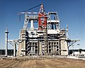
==B-2 Test Stand==
B-2 Test Stand part of large Rocket Propulsion Test Complex at the Stennis Space Center | |
 Static Test Firing S-1C Saturn V Mississippi Test Facility MTF | |
  | |
| Location | Stennis Space Center in Bay St. Louis, Hancock County, Mississippi[17] |
|---|---|
| Coordinates | 30°21′45.96″N 89°36′00.72″W / 30.3627667°N 89.6002000°W |
| Built | 1961 to 1965 |
| Architect | NASA |
| NRHP reference No. | 85002805 |
| Significant dates | |
| Added to NRHP | October 3, 1985[18] |
| Designated NHL | October 3, 1985[19] |
B-2 Test Stand was designed in 1961 and construction started in June 1961. B-2 Test Stand was completed in spring 1965 at the NASA Mississippi Test Facility, now known as Stennis Space Center. B-2 Test Stand was build to be albe to hold down 53,000 kN (12,000,000 lbf) of thurst. Also on the B-2 Test Stand, was the testing of S-IC-1 (Apollo 4), fired two times; S-IC-2 (Apollo 6) fired once; and S-IC-3 (Apollo 8) fired one time. In 1974, the B-2 Test Stand was reconfigured to test engines for the Space Shuttle program. Next the stand was change to test Russian RD-180 rocket engine in 1998, used on the Atlas rockets. The Space Launch System liquid oxygen feed line was tested in 2014 on stand.[20][21][22]
A total of 12 S-IC stages were tested on B-2 stand. The first in April 1967 and the last was in October 1970. S-IC 15 was tested but was not used,it is on display at the Stennis Space Center's Infinity Space Center. [23] The RS-68 used on the Delta 4 Common Booster Core was tested from November 1999 to May 2001. [24][25] Stennis Space Center has other test stands including: A-1/A-2 Test stands, A-3 Test stand, H-1 Test stand and E Test stand complex.[26]
The B-2 Test Stand has been renamed over the years, these include:[27]
- Building 4670
- Saturn Static Test Stand
- Saturn V Booster Test Stand
- Saturn V S-IC Static Test Stand
- S-IC Static Test Complex
- Advanced Engine Test Facility
- Specifications:[28]
- Concrete: 12,000,000 lb (5,400,000 kg)
- Fountion deepth: 12 m (40 ft)
- Four concrete foundation leg walls: 15 m (48 ft) thick and 44 m (144 ft) tall
- Crane with a 41 m (135 ft) boom, lift up to 195 tons
- Max height: 140 m (450 ft), including crane, (largest struture in Mississippi at the time)
- Base floor space: 58 m (190 ft) by 50 m (165 ft)
- 910,000 litres (240,000 US gal) of water a minute for cooling engine exhaust
- 350,000 litres (92,000 US gal) of water per minute for vibro-acoustic protection
==Gallery==
-
 A Space Launch System Rocket Core at Stennis prior to being lifted onto the B2 test stand
 -
 Wernher von Braun with the F-1 engines of the Saturn V first stage at the U.S. Space and Rocket Center
 -
 The B-2 Test Stand holding Space Shuttle component in 1987
 -
 B-1 Test Stand in 1995
 -
 SSME is Hoisted into the B1 Test Stand in 1989
 -
 SSME Night Firing in 1992
 -
 Stennis Space Center B1 Test Stand blast ports


.jpeg)
.jpeg)
.jpeg)

==See also==
==References==
- ^ https://astrobiology.nasa.gov/news/exoplanets-with-complex-life-may-be-very-rare-even-in-their-habitable-zones/
- ^ Azzam, Zaher S.; Sharabi, Kfir; Guetta, Julia; Bank, Erin M.; Gruenbaum, Yosef (15 April 2010). "The physiological and molecular effects of elevated CO2 levels". Cell Cycle (Georgetown, Tex.). 9 (8): 1528–1532. doi:10.4161/cc.9.8.11196. PMID 20372066 – via PubMed.
- ^ Thorne, Muriel, ed. (May 1983). NASA, The First 25 Years: 1958-1983 (PDF). Washington, D.C.: National Aeronautics and Space Administration. p. 69.
- ^ https://www.nasa.gov/history/45-years-ago-first-main-propulsion-test-assembly-firing-of-space-shuttle-main-engines/
- ^ https://www.nasa.gov/image-article/saturn-v-s-ic-t-stage-heads-test-stand/
- ^ https://www.nasa.gov/image-article/this-week-nasa-history-s-ic-t-arrives-marshall-april-9-1967/
- ^ https://www.nasa.gov/history/45-years-ago-first-main-propulsion-test-assembly-firing-of-space-shuttle-main-engines/
- ^ https://www.nasa.gov/image-article/saturn-v-s-ic-t-stage-heads-test-stand/
- ^ https://www.smithsonianmag.com/air-space-magazine/we-built-saturn-v-180964759/
- ^ Adavnce Engine Test Facility, George C. Marshall Space Flight Center, Huntsville, Alabama, National Historic Mechanical Engineering Landmark, Designated October 28, 1993
- ^ https://www.nasa.gov/history/45-years-ago-first-main-propulsion-test-assembly-firing-of-space-shuttle-main-engines/
- ^ https://www.nasa.gov/image-article/saturn-v-s-ic-t-stage-heads-test-stand/
- ^ https://www.asme.org/about-asme/engineering-history/landmarks/52-saturn-v-rocket
- ^ https://www.spaceflorida.gov/projects/apollo-saturn-v-center/
- ^ https://www.kennedyspacecenter.com/explore-attractions/race-to-the-moon/featured-attraction/saturn-v-rocket
- ^ https://archive.org/details/MSFC-6520223
- ^ https://www.nasa.gov/stennis/
- ^ "National Register Information System". National Register of Historic Places. National Park Service. 23 January 2007.
- ^ "Rocket Propulsion Test Complex". National Historic Landmark summary listing. National Park Service. Archived from the original on 28 July 2007. Retrieved 19 October 2007.
- ^ http://heroicrelics.org/msfc/test-stand-s-ic/index.html
- ^ NASA (February 1967). "Saturn V Quarterly Report #16 Sep–Nov 1966 Part 1 of 2". NASA. Archived from the original on 19 December 2021. Retrieved 12 February 2011.
- ^ Wright, Mike. "Three Saturn Vs on Display Teach Lessons in Space History". Marshall Space Flight Center History Office. Archived from the original on 15 November 2005. Retrieved 10 February 2011.
- ^ "Space Gallery". INFINITY Science Center. Archived from the original on 7 May 2015. Retrieved 8 July 2022.
- ^ B-2 Test Stand, NASA
- ^ https://www.nasa.gov/stennis/engineering-and-test-directorate/test-complex/b%E2%80%902-test-facility/
- ^ https://www.nasa.gov/stennis/
- ^ http://heroicrelics.org/msfc/test-stand-s-ic/index.html
- ^ http://heroicrelics.org/msfc/test-stand-s-ic/index.html
28°36′17″N 80°40′10″W / 28.604806°N 80.669444°W
==External links==
| Facilities |
| |||||||
|---|---|---|---|---|---|---|---|---|
| Launch sites | ||||||||
Spaceflight National Historic Landmarks | ||
|---|---|---|
| Alabama |  | |
| Florida | ||
| Arizona | ||
| California | ||
| Mississippi | ||
| New Mexico | ||
| Ohio | ||
| Texas | ||
| Maryland | ||
| Virginia | ||
Spaceflight programs | |||||||||||||||||||||||||||||||||||||||||||||||||||
|---|---|---|---|---|---|---|---|---|---|---|---|---|---|---|---|---|---|---|---|---|---|---|---|---|---|---|---|---|---|---|---|---|---|---|---|---|---|---|---|---|---|---|---|---|---|---|---|---|---|---|---|
| |||||||||||||||||||||||||||||||||||||||||||||||||||

Category:Apollo program
Category:Rocket stages
Category:Saturn V
Lithium[edit]
Low levels of lithium are also a key to low large solar flare events. For its age the Sun has a low level of Lithium. All Solar analog today have high lithium levels, taking into account the age of the star. Large solar flare events. Low solar flare events are very important to low luminosity variation. It may be that stars with planets have lower level of lithium, but in these stars the lithium levels are still much higher than the Sun's. [1] [2]
life zones[edit]
List of potentially habitable exoplanets
Add Comparion
https://news.ucr.edu/sites/default/files/styles/large/public/2019-06/chart.jpg?itok=tYLyHD-l
- Carbon Dioxide habitable zone is the place the planets will have the correct levels of carbon dioxide. The range for carbon dioxide levels is very narrow for life. The gas, Carbon dioxide, is essential for life. Life forms use carbon dioxide to regulate respiration and control blood pH. Plants use carbon dioxide to create oxygen through photosynthesis. High carbon dioxide levels causes hypercapnia.
Example[edit]
- Example planets and Life habitable zones. (if a zone is not list there is not enough data):
- Earth is in all known Life habitable zones with a stable star.
- Mars:
- Stable star the -Sun:
- Just on the edge of the habitable zone (water)
- In Optimistic habitable zone
- Out of Continuously habitable zone
- Out of Conservative habitable zone
- In Ultraviolet habitable zone
- At edge of Photosynthetic habitable zone
- Out of Tropospheric habitable zone
- In Planet rotation rate habitable zone
- At edge of Planet rotation axis tilt habitable zone
- Out of Astrosphere habitable zone
- Out of Atmosphere electric field habitable zone
- On edge of Tidal habitable zone
- In Orbital eccentricity habitable zone
- Out of Carbon Dioxide habitable zone
- In Orbital eccentricity habitable zone
- Out of Coupled planet-moon - Magnetosphere habitable zone
- Out Pressure-dependent habitable zone
- In Galactic habitable zone
- In Supergalactic Habitable Zone
- Out of Habitable Zone for Complex Life
- Kepler-1606b, gas giant or super-Earth:[10]
- In Habitable zone (water)
- In Ultraviolet habitable zone
- Unstable star (G-type star with high metallicity)
- Out of Astrosphere habitable zone (Super earth)
- Out Ultraviolet habitable zone (too close to star 0.6421 AU)
- Kepler-1701b, gas giant:[11]
- In Habitable zone (water)
- In Ultraviolet habitable zone
- Unstable star ([K-type main-sequence star|K1]] high metallicity)
- Out of Astrosphere habitable zone (Neptune-like)
- Out Ultraviolet habitable zone (too close to star 0.5608 AU)
- Kepler-62e, super-Earth:
- In Habitable zone (water)
- Edge of Ultraviolet habitable zone
- Unstable star (small old K-type)
- Out Ultraviolet habitable zone (too close to star 0.427 AU)
- Out of Astrosphere habitable zone (too large and close)
- Kepler-442b, super-Earth:
- In Habitable zone (water)
- Out of Astrosphere habitable zone (too large and close)
- Unstable star (Young K-type, low metallicity)
- Out Ultraviolet habitable zone (too close to star 0.409 AU)
- In Eccentricity Zone 0.04
Gliese 667 Cc, super-Earth:
- In Habitable zone (water)
- Out of Astrosphere habitable zone (too large)
- Unstable star (Red dwarf)
- Out Ultraviolet habitable zone (too close to star 0.1251 AU)
- Out of Astrosphere habitable zone
- Out of Eccentricity habitable zone at 0.133
Kepler-1229b, super-Earth:
- In Habitable zone (water)
- Out of Carbon Dioxide habitable zone
- Unstable star (Red dwarf)
- Out Ultraviolet habitable zone (too close to star 0.289 AU)
- Out of Astrosphere habitable zone
Kepler-62f, super-Earth:
- In Habitable zone (water)
- Out of Carbon Dioxide habitable zone
- Unstable star (Red dwarf)
Kepler-186f, near Earth-sized:
- In Habitable zone (water)
- Out of Carbon Dioxide habitable zone
- Unstable star (Red dwarf)
- Out Ultraviolet habitable zone (too close to star 0.432 AU)
- Out of Astrosphere habitable zone
Proxima Centauri b near Earth-sized:
- In Habitable zone (water)
- Out of Carbon Dioxide habitable zone
- Unstable star (Red dwarf)
- Out Ultraviolet habitable zone (too close to star 0.048 AU)
- Out of Astrosphere habitable zone
Note[edit]
++++++++++++++++++++++
To re-use Wikipedia's content, Wikipedia's licensing requires one attribution to the original contributor(s). When copying within Wikipedia, this is supplied at minimum in an edit summary at the page into which copied content, disclosing the copying and linking to the copied page, e.g., copied content from [[page name]]; see that page's history for attribution. It is good practice, especially if copying is extensive, to also place a properly formatted {{copied}} template on the talk pages of the source and destination. Please provide attribution for this duplication if it has not already been supplied by another editor, and if you have copied material between pages before, even if it was a long time ago, you should provide attribution for that also. See Wikipedia:Copying within Wikipedia.
++++++++++++++++++++++
Seabee: https://www.seabees93.net/GI%20Naval%20Construction%20Battalions.htm
BSC
Bethany Christian School
Bethany Christian School
++++
Naval Base Palau to do Naval Base Morotai Wama Airfield) Pitu Airport) "Morotai" "Seabee"
Aussi and NZ base, Netherlands - few US Bases
https://pacificwrecks.com/provinces/indonesia.html
+++++++
- SS Jean Nicolet crime
- SS Beha crime
- SS Poelau Bras (1929) crime https://nl.wikipedia.org/wiki/Poelau_Bras_(schip,_1929) http://muntokpeacemuseum.org/?page_id=27
- SS Black Point last boat sunk
- Reserve Fleet Mobile AL
Anomalous Earth elements[edit]
Abundance of the chemical elements Rare-earth element Abundance of elements in Earth's crust
The r-process is known to occur in core-collapse supernovae https://reasons.org/explore/publications/articles/thank-god-for-merging-neutron-stars
The s-process converts elements produced by the r-process into different heavy elements. [13] [14]
A review of anomalous rare earth elements and yttrium in coal
https://www.sciencedirect.com/science/article/abs/pii/S016651621630115X
Anomalous Earth elements
Vital poisons also called Essential poisons are poisons that at high dose will cause death or damage to living organisms, but are needed at low trace doses for living organism to survive and live healthy. In high doses these poisons can be lethal, but, micro or trace amounts are essential for good health. The these traces elements come from inorganic minerals. A number of vital poisons are essential for making proteins and other vital biochemical metabolism functions. Proteins are base for biological cells.[15]
[16][17] In most cases a normal healthy diet can supply these traces chemical elements needed for human nutrition. All the elements are found in the Earth's crust in the correct amount in most soils.[18] Biomineralization and geomicrobiology activities has concentrated inorganic mineral in the Earth's crust over a long time span, like sulfate-reducing bacteria and hydrogen oxidizing bacteria. [19] [20]
Moon[edit]
The Moon forming impact account for some, but not all, of the Anomalous levls of Earth elements. [21][22]
Formation location[edit]
Jupiter and Saturn movements in the early formation of the Solar System may have given Earth a boost in some elements. Late Heavy Bombardment boost in some elements. [23][24]
Anomalous elements[edit]
This increase or decreace of abundance notes is by mass, relative to magnesium’s abundance (which ranks eighth in Earth’s crust). The comparsion is in Earth’s crust is compared the Milky Way Galaxy. Magnesium is used as the refferance as it is about the same percentage in Earth as the Milky Way Galaxy.
Asterisks denote elements critical for advanced life.
https://reasons.org/explore/publications/nrtb-e-zine/earth-s-chlorine-abundance-fine-tuned-for-life
aluminium[edit]
40 times more
Antimony[edit]
Antimony 10 times more. Antimony in Earth's crust range from 0.2 to 0.5 parts per million.
Arsenic[edit]
Arsenic is an inorganic chemical element. Trace quantities of arsenic are an essential dietary element. A normal healthy diet will easily supply the trace arsenic needed. Early test show that arsenic has a role in gene silencing and the metabolism of the amino acid methionine. At high does arsenic poisoning is very dangerous.[27] [28][29][30] [31][32]
Boron[edit]
Boron is an essential inorganic chemical needed by plants and animals, it is required for cell walls. Too low of a level causes boron deficiency. At high levels boron can become toxic. [33][34][35][36][37]
calcium[edit]
calcium 20 times more
Carbon[edit]
Carbon 1,200 times less.
Chromium[edit]
Chromium 5 times less Chromium, an essential inorganic chemical, thought to be used for insulin, a hormone critical to the metabolism and storage of carbohydrate, fat and protein. Too low intake can cause chromium deficiency. At high levels causes harmful chromium toxicity. [38][39] [40][41][42]
Chlorine[edit]
Chlorine 3 times more. [43] Chlorine is an essential inorganic chemical. Chlorine in the form of chloride ions are necessary to all known species of life. Many chlorine compounds are needed in life. Chlorine helps in digestion, by helping form hydrochloric acid. Sodium chloride is found in sweat and tears. Chlorine is a negatively charged ion in blood forming a electrolyte. Chloride deficiency is rare as as some chlorine is in all foods, but extreme sweating can cause a sharp drop in chlorine. Yet chlorine at high concentrations is extremely poisonous for all living organisms. [44] [45]
Cobalt[edit]
6 times less Cobalt is an inorganic ultratrace element, as very small trace amounts of are needed for the synthesis of Vitamin B12. Beneficial bacteria are also required to synthesize the vitamin B12. Some volcanic soils lacked the cobalt salts essential for the ruminant cattle/bacteria food chain.[46] Too high of level causes cobalt poisoning.[47][48] [49]
Copper[edit]
21 times more.
Copper is necessary to all living things. Copper is an inorganic compound needed for health of all living cells. Copper is used in proteins and metalloenzymes. Like all essential elements too much or too little copper can result in copper toxicity or a copper deficiency both with adverse health effects. [50] Chronically elevated levels of copper intake produces zinc deficiency.[50][51][52] [53]
gold[edit]
5 times less
Fluorine[edit]
Fluorine 50 times more than normal for earh size planet.
Fluorine is a rare poisonous inorganic gas, yet the fluorine is needed for life. Fluoride also reduces tooth decay if take at the correct levels. Fluorine in high levels can turn teeth to a dark brown color and cause fluoride toxicity. [54][55][56]
Iodine[edit]
4 time more
Iodine is an essential inorganic element needed for life. Iodine is the heaviest element needed by living organisms. Iodine is needed for the synthesis of the growth-regulating thyroid hormones thyroxine and triiodothyronine Iodine deficiency leads to an enlargement of the thyroid tissue a disease called simple goitre. Too much iodine is toxic.[57] [58][59][60] [61] One study concluded the range of total body iodine content in males was 12.1 mg to 25.3 mg, with a mean of 14.6 mg.[62]
Iron[edit]
Iron an inorganic metal and is part of numerous biological processes.[63][64] Iron is the most important transition metal in all living organisms.[65] Iron-proteins are found in all living organisms: Too little iron causes iron deficiency. Iron at high levels causes iron poisoning and iron overload.[66][67][68][69]
Lead[edit]
170 times more
Manganese[edit]
3 times more Manganese is a required inorganic trace mineral for all known living organisms, with the exception of neurotoxin. Manganese ions are a cofactors for a many enzymes. [70] In life forms that use oxygen, manganese enzymes are essential in detoxification of superoxide free radicals. In large amounts manganese can cause poisoning in mammals.
Molybdenum[edit]
5 time more Molybdenum an inorganic element is used by organism in nitrogen fixation. Nitrogen fixation is used by plants to get nitrogen from the atmosphere. Nitrogen fixation is need so element can be attaches to chemicals that can be assimilated by plants. Most of Earth's soil has the right amount of molybdenum. In humans molybdenum is use as a catalyst for enzymes and to help breakdown of some amino acids. Too little can cause Molybdenum deficiency. Yet, too much molybdenum can cause brain damage.[71][72] However, it can occur in individuals receiving parenteral nutrition.[73][74]
Nickel[edit]
20 times less
Nickel is a inorganic metal needed by some microorganisms and plants. Nickel in plant enzyme urease, helps in hydrolysis of urea. The enzyme hydrogenases contain nickel. The enzyme Cofactor F430 uses nickel. Nickel allergy can form with too much exposures to nickel in some people. [75][76] [77] [78] [79][80][81][82][83][84][85]
Niobium[edit]
Niobium 170 times more
Nitric oxide[edit]
Nitric oxide (NO) is a inorganic poisons gas, yet trace amounts are very important to life. In mammals Nitric oxide is an important cellular signaling molecule involved in many physiological and pathological processes.[86] Low levels of nitric oxide production are important in protecting organs such as the liver from ischemic damage. Due to Nitric oxide importance in neuroscience, physiology, and immunology, Nitric oxide was proclaimed "Molecule of the Year" in 1992.[87] Research into its function led to the 1998 Nobel Prize for discovering the role of nitric oxide as a cardiovascular signalling molecule. Nitric oxide should not be confused with nitrous oxide (N2O), an anaesthetic, or with nitrogen dioxide (NO2), a brown toxic gas and a major air pollutant, the latter being a product to which nitric oxide is rapidly oxidised in air. [88][89][90]
Nitrogen[edit]
nitrogen 2,400 times less.
Phosphorus[edit]
Four times than noraml for earth type plant. [91]
Phosphorus is an inorganic essential element needed for all life forms. Phosphates are a needed part of DNA, RNA, ATP. All cell membranes use phosphate in the form of phospholipids. Phosphorus deficiency can cause hypophosphatemia. Too much phosphorus is toxic, notable in aquatic systems.[92] [93][94]
Potassium[edit]
90 time more
Potassium is an inorganic element needed for multiple physiological processes.[95][96][97]Diets low in potassium can lead to hypertension[98] and hypokalemia. Potassium at high levels can cause potassium poisoning, called hyperkalemia.[99]
Selenium[edit]
30 times more
Selenium is an inorganic micronutrient at trace levels. Needed for antioxidant enzymes, like glutathione peroxidase. Too low of level will cause selenium deficiency. Selenium pollution can cause high levels that are poisonous. [100]
Silver[edit]
3 time more
Sodium[edit]
Sodium* 20 times more
Sulfur[edit]
60 times less
Sulfur is an inorganic essential element of all living cells. In plants and animals, the amino acids cysteine and methionine contain the most sulfur.[103] While pure sulfur is non-toxic, sulfur in the form of sulfur trioxide,[104] sulfuric acid [105]and hydrogen sulfide are toxic.[106]
Tin[edit]
3 time more
Tin is an inorganic metal used in a variety of biological activities including the immune system. Too high of levels can cause tin poisoning.[107][108]
titanium[edit]
65 times more
thorium[edit]
thorium 610 time more
uranium[edit]
uranium 340 times more uranium and thorium are need to have Earh's magnetic field over the history of Earth. The isotope decay of these provide a lot of heat for inside layers of the Earth, which being molten and in motion provide our magnetic field. That not only protects us from dangerous radiation, but it protects us from having the radiation blast away our atmosphere. factor is very key to our planet working for life. [110]
Water[edit]
250 times less [111]
Vanadium[edit]
9 times more Vanadium is an inorganic ultratrace element, very small trace amounts are needed for some DNA-metabolizing enzymes. At high level vanadium is toxic.[112][113] Vanadium is very important in marine life forms.[114]
Yttrium[edit]
yttrium 50 times more
Zinc[edit]
6 times more Zinc is an inorganic metal that is an essential trace element.[115] [116] [117][118] Zinc is found in nearly 100 specific enzymes. [119] Too little zinc can cause Zinc deficiency[120] Too high of levels of zinc can cause zinc toxicity. [121]
Zirconium[edit]
Zirconium 130 times more
See also[edit]
References[edit]
- ^ Lithium depletion in solar-like stars: no planet connection, by Patrick Baumann, Iv´an Ram´ ırez, Jorge Mel´endez, Martin Asplund, and Karin Lind, Astronomy & Astrophysics manuscript no. 15137, June 28, 2010
- ^ https://www.aanda.org/articles/aa/full_html/2010/04/aa14125-10/aa14125-10.html
- ^ https://www.aanda.org/articles/aa/full_html/2010/04/aa14125-10/table1.html
- ^ Meléndez, Jorge; Ramírez, Iván (November 2007). "HIP 56948: A Solar Twin with a Low Lithium Abundance". The Astrophysical Journal. 669 (2): L89–L92. arXiv:0709.4290. Bibcode:2007ApJ...669L..89M. doi:10.1086/523942. S2CID 15952981.
- ^ Carlos, Marília; Nissen, Poul E.; Meléndez, Jorge (2016). "Correlation between lithium abundances and ages of solar twin stars". Astronomy & Astrophysics. 587: A100. arXiv:1601.05054. Bibcode:2016A&A...587A.100C. doi:10.1051/0004-6361/201527478. S2CID 119268561.
- ^ do Nascimento Jr., Jose Dias; Castro, Matthieu Sebastien; Meléndez, Jorge; Bazot, Michaël; Théado, Sylvie; Porto de Mello, Gustavo Frederico; De Medeiros, José Renan (2009). "Age and mass of solar twins constrained by lithium abundance". Astronomy and Astrophysics. 501 (1): 687–694. arXiv:0904.3580. Bibcode:2009A&A...501..687D. doi:10.1051/0004-6361/200911935. S2CID 9565600.
- ^ Hultqvist, L. (1 April 1977). "The production of lithium in the solar chromosphere and photosphere during white light flares". Solar Physics. 52: 101–106. doi:10.1007/BF00935793 – via NASA ADS.
- ^ https://astrobiology.nasa.gov/news/exoplanets-with-complex-life-may-be-very-rare-even-in-their-habitable-zones/ Exoplanets With Complex Life May Be Very Rare, Even in Their “Habitable Zones”, nasa.gov]
- ^ Schwieterman, Edward W., et al. "A limited habitable zone for complex life." The Astrophysical Journal 878.1 (2019): 19
- ^ https://exoplanets.nasa.gov/exoplanet-catalog/2252/kepler-1606-b/
- ^ https://exoplanets.nasa.gov/exoplanet-catalog/7742/kepler-1701-b/
- ^ http://what-when-how.com/the-american-economy/defense-plant-corporation-dpc/
- ^ Takuji Tsujimoto et al., “Chemical Feature of Eu Abundance in the Draco Dwarf Spheroidal Galaxy,” Publications of the Astronomical Society of Japan 67 (June 2015): id. L3, doi:10.1093/pasj/psv035; Nial Tanvir et al., “A ‘Kilonova’ Associated with the Short-Duration Gamma-Ray Burst GRB 130603B,” Nature 500 (August 2013): 547–49, doi:10.1038/nature12505; A. Wallner et al., “Abundance of Live 244Pu in Deep-Sea Reservoirs on Earth Points to Rarity of Actinide Nucleosynthesis,” Nature Communications 6 (January 2015): id. 5956, doi:10.1038/ncomms6956.
- ^ Alexander Ji et al., “R-process Enrichment from a Single Event in an Ancient Dwarf Galaxy,” Nature 531 (March 2016): 610–13, doi:10.1038/nature17425.
- ^ Lead, Arsenic, Aluminum and Mercury… Vital Trace Elements or Toxic Poisons? by Dr. William J. Saccoman
- ^ The Bioaccessibility, Phytoavailability, and Speciation of Selected Heavy Metals and Metalloids in Biosolids from the State of New Jersey, page 29, Monmouth University, Katharine Dilger and Melissa Mooney
- ^ Selenium and nano-selenium in agroecosystems, by Attila Sztrik, 2014
- ^ National Academies Press, by the National Academy of Sciences, Diet and Health: Implications for Reducing Chronic Disease Risk, Trace Elements, Page 367, 1989
- ^ Aquatic geomicrobiology, 2005, published by Lsevier Acad. London, isbn 0121583406, by Donald E. Canfield
- ^ Harris, Ph.D., Edward D. (1 January 2014). Minerals in Food Nutrition, Metabolism, Bioactivity (1st ed.). Lancaster, PA: DEStech Publications, Inc. p. 378. ISBN 978-1-932078-97-8. Retrieved 30 January 2015.
- ^ https://www.sciencedirect.com/science/article/abs/pii/S0019103503002999
- ^ https://ui.adsabs.harvard.edu/abs/2008Icar..196..518C/abstract
- ^ https://www.science.org/doi/10.1126/science.306.5702.1676a
- ^ https://ui.adsabs.harvard.edu/abs/2002Natur.418..403S/abstract
- ^ ]https://iopscience.iop.org/article/10.1086/591433 ]
- ^ Eric Gaidos et al., “26Al and the Formation of the Solar System from a Molecular Cloud Contaminated by Wolf-Rayet Winds,” Astrophysical Journal 696, May 10, 2009, 1854–63.
- ^ Science and Society Analysis, A toxic brew we cannot live without. Micronutrients give insights into the interplay between geochemistry and evolutionary biology, by Philip Hunter, 2008 Jan. 9, doi: 10.1038/sj.embor.7401148 PMCID: PMC2246629
- ^ Anke M. (1986) "Arsenic", pp. 347–372 in Mertz W. (ed.), Trace elements in human and Animal Nutrition, 5th ed. Orlando, FL: Academic Press
- ^ Uthus E.O. "Evidency for arsenical essentiality". doi:10.1007/BF01783629. PMID 24197927.
{{cite journal}}: Cite journal requires|journal=(help) - ^ Uthus E.O. (1994) "Arsenic essentiality and factors affecting its importance", pp. 199–208 in Chappell W.R, Abernathy C.O, Cothern C.R. (eds.) Arsenic Exposure and Health. Northwood, UK: Science and Technology Letters.
- ^ Lead, Arsenic, Aluminum and Mercury… Vital Trace Elements or Toxic Poisons?, by Dr. William J. Saccoman
- ^ Environ Geochem Health, Evidence for arsenic essentiality, 1992 June 14, doi: 10.1007/BF01783629
- ^ Mahler, R. L. "Essential Plant Micronutrients. Boron in Idaho" (PDF). University of Idaho. Archived from the original (PDF) on 1 October 2009. Retrieved 5 May 2009.
- ^ "Functions of Boron in Plant Nutrition" (PDF). U.S. Borax Inc. Archived from the original (PDF) on 20 March 2009.
- ^ Blevins, Dale G.; Lukaszewski, KM (1998). "Functions of Boron in Plant Nutrition". Annual Review of Plant Physiology and Plant Molecular Biology. 49: 481–500. doi:10.1146/annurev.arplant.49.1.481. PMID 15012243.
- ^ Nielsen, Forrest H. (1998). "Ultratrace elements in nutrition: Current knowledge and speculation". The Journal of Trace Elements in Experimental Medicine. 11 (2–3): 251–274. doi:10.1002/(SICI)1520-670X(1998)11:2/3<251::AID-JTRA15>3.0.CO;2-Q.
- ^ "Boron". PDRhealth. Archived from the original on 11 October 2007. Retrieved 18 September 2008.
- ^ Anderson, R. A. (1997). "Chromium as an Essential Nutrient for Humans". Regulatory Toxicology and Pharmacology. 26 (1 Pt 2): S35–S41. doi:10.1006/rtph.1997.1136. PMID 9380836.
- ^ "Chromium". Office of Dietary Supplements, US National Institutes of Health. 2016. Retrieved 26 June 2016.
- ^ European Food Safety Authority (2014). "Scientific Opinion on Dietary Reference Values for chromium". EFSA Journal. 12 (10): 3845. doi:10.2903/j.efsa.2014.3845.
- ^ Vincent, John B. (2013). "Chapter 6. Chromium: Is It Essential, Pharmacologically Relevant, or Toxic?". In Astrid Sigel; Helmut Sigel; Roland K. O. Sigel (eds.). Interrelations between Essential Metal Ions and Human Diseases. Metal Ions in Life Sciences. Vol. 13. Springer. pp. 171–198. doi:10.1007/978-94-007-7500-8_6.
- ^ Bona, Kristin R.; Love, Sharifa; Rhodes, Nicholas R.; McAdory, Deana; Sinha, Sarmistha Halder; Kern, Naomi; Kent, Julia; Strickland, Jessyln; Wilson, Austin; Beaird, Janis; Ramage, James; Rasco, Jane F.; Vincent, John B. (2011). "Chromium is not an essential trace element for mammals: Effects of a "low-chromium" diet". JBIC Journal of Biological Inorganic Chemistry. 16 (3): 381–90. doi:10.1007/s00775-010-0734-y. PMID 21086001.
- ^ https://www.sciencedirect.com/science/article/abs/pii/S0012821X13001192
- ^ Trace minerals,Chloride: The Forgotten Essential Mineral, By Dr. Chris Meletis N. D.
- ^ Living organisms and chemistry
- ^ "Soils". Waikato University. Retrieved 16 January 2012.
- ^ Yamada, Kazuhiro (2013). "Chapter 9. Cobalt: Its Role in Health and Disease". In Astrid Sigel; Helmut Sigel; Roland K. O. Sigel (eds.). Interrelations between Essential Metal Ions and Human Diseases. Metal Ions in Life Sciences. Vol. 13. Springer. pp. 295–320. doi:10.1007/978-94-007-7500-8_9.
- ^ Cracan, Valentin; Banerjee, Ruma (2013). "Chapter 10 Cobalt and Corrinoid Transport and Biochemistry". In Banci, Lucia (ed.). Metallomics and the Cell. Metal Ions in Life Sciences. Vol. 12. Springer. doi:10.1007/978-94-007-5561-10_10. ISBN 978-94-007-5560-4. electronic-book ISBN 978-94-007-5561-1 ISSN 1559-0836 electronic-ISSN 1868-0402
- ^ Schwarz, F. J.; Kirchgessner, M.; Stangl, G. I. (2000). "Cobalt requirement of beef cattle – feed intake and growth at different levels of cobalt supply". Journal of Animal Physiology and Animal Nutrition. 83 (3): 121–131. doi:10.1046/j.1439-0396.2000.00258.x.
- ^ a b Sandstead HH (1995). "Requirements and toxicity of essential trace elements, illustrated by zinc and copper". Am. J. Clin. Nutr. 61 (3 Suppl): 621S–624S. PMID 7879727.
- ^ Batley, G. E., & Florence, T. M. (1976). Determination of the chemical forms of dissolved cadmium, lead and copper in seawater. Marine Chemistry, 4(4), 347-363.
- ^ Van Den Berg, C. M. (1984). Organic and inorganic speciation of copper in the Irish Sea. Marine Chemistry, 14(3), 201-212.
- ^ "Copper Toxicity". Retrieved 24 November 2015.
- ^ Gosselin, RE; Smith RP; Hodge HC (1984). Clinical toxicology of commercial products. Baltimore (MD): Williams & Wilkins. pp. III-185–93. ISBN 0-683-03632-7.
- ^ Baselt, RC (2008). Disposition of toxic drugs and chemicals in man. Foster City (CA): Biomedical Publications. pp. 636–40. ISBN 978-0-9626523-7-0.
- ^ IPCS (2002). Environmental health criteria 227 (Fluoride). Geneva: International Programme on Chemical Safety, World Health Organization. p. 100. ISBN 92-4-157227-2.
- ^ globalhealingcenter.com, Symptoms of Iodine Overdose, by Dr. Edward Group, August 13, 2013
- ^ Smyth, PP (2003). "Role of iodine in antioxidant defence in thyroid and breast disease". BioFactors (Oxford, England). 19 (3–4): 121–30. doi:10.1002/biof.5520190304. PMID 14757962.
- ^ Patrick, L. (2008). "Iodine: deficiency and therapeutic considerations" (PDF). Altern Med Rev. 13 (2): 116–27. PMID 18590348.
- ^ Yerkes, Christine (2007). "Lecture 29: Protein Structure and Denaturation". chem.uiuc.edu. University of Illinois. Retrieved 23 October 2016.
- ^ Nagataki, S.; Shizume, K.; Nakao, K. (1967). "Thyroid Function in Chronic Excess Iodide Ingestion: Comparison of Thyroidal Absolute Iodine Uptake and Degradation of Thyroxine in Euthyroid Japanese Subjects". Journal of Clinical Endocrinology & Metabolism. 27 (5): 638–647. doi:10.1210/jcem-27-5-638.
- ^ Hays, M. T. (2001). "Estimation of Total Body Iodine Content in Normal Young Men". Thyroid. 11 (7): 671–675. doi:10.1089/105072501750362745. PMID 11484896.
- ^ Dlouhy, Adrienne C.; Outten, Caryn E. (2013). Banci, Lucia (ed.). Metallomics and the Cell. Metal Ions in Life Sciences. Vol. 12. Springer. doi:10.1007/978-94-007-5561-1_8. ISBN 978-94-007-5560-4. electronic-book ISBN 978-94-007-5561-1 ISSN 1559-0836 electronic-ISSN 1868-0402
- ^ Yee, Gereon M.; Tolman, William B. (2015). Peter M.H. Kroneck; Martha E. Sosa Torres (eds.). Sustaining Life on Planet Earth: Metalloenzymes Mastering Dioxygen and Other Chewy Gases. Metal Ions in Life Sciences. Vol. 15. Springer. pp. 131–204. doi:10.1007/978-3-319-12415-5_5.
- ^ Greenwood and Earnshaw, pp. 1098–1104
- ^ Valentine, Kevin; Mastropietro, Christopher; Sarnaik, Ashok P. "Infantile iron poisoning: Challenges in diagnosis and management". Pediatric Critical Care Medicine. 10 (3): e31–e33. doi:10.1097/pcc.0b013e318198b0c2.
- ^ "Iron Toxicity, What You Don't Know". Plants Poisonous to Livestock. Cornell University Department of Animal Science. Retrieved 9 April 2012.
- ^ Tenenbein, M. (June 2005). "Unit-Dose Packaging of Iron Supplements and Reduction of Iron Poisoning in Young Children". Arch Pediatr Adolesc Med. 159: 557–560. doi:10.1001/archpedi.159.6.557. PMID 15939855.
- ^ "AAPCC Annual Reports". American Association of Poison Control Centers.
- ^ Roth, Jerome; Ponzoni, Silvia; Aschner, Michael (2013). "Chapter 6 Manganese Homeostasis and Transport". In Banci, Lucia (ed.). Metallomics and the Cell. Metal Ions in Life Sciences. Vol. 12. Springer. doi:10.1007/978-94-007-5561-1_6. ISBN 978-94-007-5560-4. electronic-book ISBN 978-94-007-5561-1 ISSN 1559-0836 electronic-ISSN 1868-0402
- ^ A case report of acute human molybdenum toxicity from a dietary molybdenum supplement--a new member of the "Lucor metallicum" family, Arh Hig Rada Toksikol, 1999 Sep.5
- ^ "Linus Pauling Institute at Oregon State University". Retrieved 29 November 2008.
- ^ Sardesai VM (December 1993). "Molybdenum: an essential trace element". Nutr Clin Pract. 8 (6): 277–81. doi:10.1177/0115426593008006277. PMID 8302261.
- ^ "Molybdenum: Mineral Deficiency and Toxicity: Merck Manual Professional". Retrieved 29 November 2008.
- ^ Astrid Sigel; Helmut Sigel; Roland K. O. Sigel, eds. (2008). Nickel and Its Surprising Impact in Nature. Metal Ions in Life Sciences. Vol. 2. Wiley. ISBN 978-0-470-01671-8.
- ^ Sydor, Andrew M.; Zamble, Deborah B. (2013). "Chapter 11 Nickel Metallomics: General Themes Guiding Nickel Homeostasis". In Banci, Lucia (ed.). Metallomics and the Cell. Metal Ions in Life Sciences. Vol. 12. Springer. doi:10.1007/978-94-007-5561-10_11. ISBN 978-94-007-5560-4. electronic-book ISBN 978-94-007-5561-1 ISSN 1559-0836 electronic-ISSN 1868-0402
- ^ Stephen W., Ragdale (2014). "Chapter 6. Biochemistry of Methyl-Coenzyme M Reductase: The Nickel Metalloenzyme that Catalyzes the Final Step in Synthesis and the First Step in Anaerobic Oxidation of the Greenhouse Gas Methane". In Peter M.H. Kroneck; Martha E. Sosa Torres (eds.). The Metal-Driven Biogeochemistry of Gaseous Compounds in the Environment. Metal Ions in Life Sciences. Vol. 14. Springer. pp. 125–145. doi:10.1007/978-94-017-9269-1_6.
- ^ Wang, Vincent C.-C.; Ragsdale, Stephen W.; Armstrong, Fraser A. (2014). "Chapter 4. Investigations of the Efficient Electrocatalytic Interconversions of Carbon Dioxide and Carbon Monoxide by Nickel-Containing Carbon Monoxide Dehydrogenases". In Peter M.H. Kroneck; Martha E. Sosa Torres (eds.). The Metal-Driven Biogeochemistry of Gaseous Compounds in the Environment. Metal Ions in Life Sciences. Vol. 14. Springer. pp. 71–97. doi:10.1007/978-94-017-9269-1_4.
- ^ Szilagyi, R. K.; Bryngelson, P. A.; Maroney, M. J.; Hedman, B.; et al. (2004). "S K-Edge X-ray Absorption Spectroscopic Investigation of the Ni-Containing Superoxide Dismutase Active Site: New Structural Insight into the Mechanism". Journal of the American Chemical Society. 126 (10): 3018–3019. doi:10.1021/ja039106v. PMID 15012109.
- ^ Greig N; Wyllie S; Vickers TJ; Fairlamb AH (2006). "Trypanothione-dependent glyoxalase I in Trypanosoma cruzi". Biochemical Journal. 400 (2): 217–23. doi:10.1042/BJ20060882. PMC 1652828. PMID 16958620.
- ^ Aronsson A-C; Marmstål E; Mannervik B (1978). "Glyoxalase I, a zinc metalloenzyme of mammals and yeast". Biochemical and Biophysical Research Communications. 81 (4): 1235–1240. doi:10.1016/0006-291X(78)91268-8. PMID 352355.
- ^ Ridderström M; Mannervik B (1996). "Optimized heterologous expression of the human zinc enzyme glyoxalase I". Biochemical Journal. 314 (Pt 2): 463–467. PMC 1217073. PMID 8670058.
- ^ Saint-Jean AP; Phillips KR; Creighton DJ; Stone MJ (1998). "Unknown title". Biochemistry. 37 (29): 10345–10353. doi:10.1021/bi980868q. PMID 9671502.
- ^ Thornalley, P. J. (2003). "Glyoxalase I—structure, function and a critical role in the enzymatic defence against glycation". Biochemical Society Transactions. 31 (Pt 6): 1343–1348. doi:10.1042/BST0311343. PMID 14641060.
- ^ Vander Jagt DL (1989). "Unknown chapter title". In D Dolphin; R Poulson; O Avramovic (eds.). Coenzymes and Cofactors VIII: Glutathione Part A. New York: John Wiley and Sons.
- ^ Hou, YC; Janczuk, A; Wang, PG (1999). "Current trends in the development of nitric oxide donors". Current pharmaceutical design. 5 (6): 417–41. PMID 10390607.
- ^ Culotta, Elizabeth; Koshland, Daniel E. Jr (1992). "NO news is good news". Science. 258 (5090): 1862–1864. doi:10.1126/science.1361684. PMID 1361684.
- ^ THE VITAL ROLE OF NITRIC OXIDE by Tadeusz Malinski
- ^ Nitric oxide accounts for the biological activity of endothelium-derived relaxing factor, By Palmer R.M.J., Ferrige A.G., Moncada S., Nature 1987, 327:524–526,
- ^ CRITICAL CARE AND TRAUMA, Nitric Oxide Synthase Inhibition in Sepsis? Lessons Learned from Large-Animal Studies, by JUKKAT AKALAR, he Pennsylvania State University
- ^ M. S. Sisodia, “Evidences Support an Extraordinary Event, Possibly an Impact During the Proterozoic for Phosphorus Abundance on the Earth,” Astrobiology 8, April 2008, page 360
- ^ Phosphorus Cycle – Terrestrial Phosphorus Cycle, Transport of Phosphorus, from Continents to the Ocean, The Marine Phosphorus Cycle
- ^ Nelson, D. L.; Cox, M. M. "Lehninger, Principles of Biochemistry" 3rd Ed. Worth Publishing: New York, 2000. ISBN 1-57259-153-6.
- ^ Bernhardt, Nancy E.; Kasko, Artur M. (2008). Nutrition for the Middle Aged and Elderly. Nova Publishers. p. 171. ISBN 1-60456-146-7.
- ^ ID, Linus S, Wingo CS. Disorders of potassium metabolism. In: Freehally J, Johnson RJ, Floege J, eds. Comprehensive clinical nephrology. 5th ed.St. Louis: Saunders, 2014:118-118
- ^ Malnic G, Giebisch G, Muto S, Wang W, Bailey MA, Satlin LM. Regulation of K+ excretion. In: Alpern RJ, Caplan MJ, Moe OW, eds. Seldin and Giebisch’s the kidney: physiology and pathophysiology. 5th ed. London: Academic Press, 2013:1659-1716
- ^ Mount DB, Zandi-Nejad K. Disorders of potassium balance. In: Taal MW, Chertow GM, Marsden PA, Skorecki KL, Yu ASL, Brenner BM, eds. The kidney. 9th ed. Philadelphia: Elsevier, 2012:640-688
- ^ "Effects of oral potassium on blood pressure. Meta-analysis of randomized controlled clinical trials". JAMA. 277 (20): 1624–32. 1997. doi:10.1001/jama.1997.03540440058033. PMID 9168293.
{{cite journal}}: Cite uses deprecated parameter|authors=(help) - ^ Soar, J; Perkins, GD; Abbas, G; Alfonzo, A; Barelli, A; Bierens, JJ; Brugger, H; Deakin, CD; Dunning, J; Georgiou, M; Handley, AJ; Lockey, DJ; Paal, P; Sandroni, C; Thies, KC; Zideman, DA; Nolan, JP (October 2010). "European Resuscitation Council Guidelines for Resuscitation 2010 Section 8. Cardiac arrest in special circumstances: Electrolyte abnormalities, poisoning, drowning, accidental hypothermia, hyperthermia, asthma, anaphylaxis, cardiac surgery, trauma, pregnancy, electrocution". Resuscitation. 81 (10): 1400–33. PMID 20956045.
- ^ Lemly, Dennis (1998). Selenium Assessment in Aquatic Ecosystems: A guide for hazard evaluation and water quality criteria. Springer. ISBN 0-387-95346-9.
{{cite book}}: Cite has empty unknown parameter:|coauthors=(help) - ^ https://www.sciencedirect.com/science/article/abs/pii/S0012821X08007899
- ^ Benton Clark, “Death By Sulfur: Consequences of Ubiquitous S Before and After the Biotic Transition for Mars and Other S-Rich Planets,” Astrobiology 8, April 2008, page 433
- ^ Chemical Composition of Living Cells
- ^ U.S. Department of Health and Human Services, sulfur trioxide
- ^ U.S. Department of Health and Human Services, Sulfuric acid poisoning
- ^ U.S. Department of Health and Human Services, Hydrogen sulfide in cell survival: a double-edged sword.
- ^ U.S. Department of Health and Human Services, Biological activity of tin and immunity.
- ^ National Center for Biotechnology Information, U.S. National Library of Medicine, Tin deficiency
- ^ J. D. Gilmour and C. A. Middleton, “Anthropic Selection of a Solar System with a High 26Al/27Al Ratio: Implications and a Possible Mechanism,” Icarus 201 (June 2009): 821–23.
- ^ J. D. Gilmour and C. A. Middleton, “Anthropic Selection of a Solar System with a High 26Al/27Al Ratio: Implications and a Possible Mechanism,” Icarus 201 (June 2009): 821–23.
- ^ ]https://iopscience.iop.org/article/10.1086/591433 ]
- ^ Roschin, A. V. (1967). "Toxicology of vanadium compounds used in modern industry". Gig Sanit. (Water Res.). 32 (6): 26–32. PMID 5605589.
- ^ Toxicol Environ Health, Different effects of vanadium ions on some DNA-metabolizing enzymes. by Sabbioni E, Clerici L, Brazzelli A., 1983 Dec
- ^ Sigel, Astrid; Sigel, Helmut, eds. (1995). Vanadium and Its Role in Life. Metal Ions in Biological Systems. Vol. 31. CRC. ISBN 0-8247-9383-8.
- ^ Maret, Wolfgang (2013). "Chapter 12. Zinc and Human Disease". In Astrid Sigel; Helmut Sigel; Roland K. O. Sigel (eds.). Interrelations between Essential Metal Ions and Human Diseases. Metal Ions in Life Sciences. Vol. 13. Springer. pp. 389–414. doi:10.1007/978-94-007-7500-8_12.
- ^ Prasad A. S. (2008). "Zinc in Human Health: Effect of Zinc on Immune Cells". Mol. Med. 14 (5–6): 353–7. doi:10.2119/2008-00033.Prasad. PMC 2277319. PMID 18385818.
- ^ Broadley, M. R.; White, P. J.; Hammond, J. P.; Zelko I.; Lux A. (2007). "Zinc in plants". New Phytologist. 173 (4): 677–702. doi:10.1111/j.1469-8137.2007.01996.x. PMID 17286818.
- ^ Zinc's role in microorganisms is particularly reviewed in: Sugarman B (1983). "Zinc and infection". Review of Infectious Diseases. 5 (1): 137–47. doi:10.1093/clinids/5.1.137. PMID 6338570.
- ^ Plum, Laura; Rink, Lothar; Haase, Hajo (2010). "The Essential Toxin: Impact of Zinc on Human Health". Int J Environ Res Public Health. 7 (4): 1342–1365. doi:10.3390/ijerph7041342. PMC 2872358. PMID 20617034.
{{cite journal}}: CS1 maint: unflagged free DOI (link) - ^ [https://ods.od.nih.gov/factsheets/Zinc-HealthProfessional/ U.S. Department of Health and Human Services, Zinc Fact Sheet for Health Professionals]
- ^ Fosmire GJ (February 1990). "Zinc toxicity". Am. J. Clin. Nutr. 51 (2): 225–7. PMID 2407097.
Category:Dietary minerals Category:Poisons
| Inorganic |
| ||||||||||||
|---|---|---|---|---|---|---|---|---|---|---|---|---|---|
| Organic |
| ||||||||||||
| Pharmaceutical |
| ||||||||||||
| Biological2 |
| ||||||||||||
| Miscellaneous | |||||||||||||
| |||||||||||||
| Fields | |
|---|---|
| Concepts | |
| Treatments | |
| Incidents | |
| Related topics | |
This biochemistry article is a stub. You can help Wikipedia by expanding it. |
This article about metabolism is a stub. You can help Wikipedia by expanding it. |
Anomalous Moon[edit]
Anomalous Moon Roation axi tilt Large for sixe, asrto impacts low diesity Funnel in high disnes Tide and earht roations
23 more
External links[edit]
- old Official website
- Official website
- Dutch Nugget Register — Unofficial Dutch Web site of Nugget owners
- nuggetforum.de — Unofficial German Westfalia Nugget Community
51°50′42.15″N 8°18′28.61″E / 51.8450417°N 8.3079472°E
Category:Recreational vehicle manufacturers Category:Volkswagen vehicles
Mars carbonate catastrophe[edit]
Mars carbonate catastrophe was an event that happened on Mars in its early history. Evidence shows Mars was once warmer and wet about 4 billion years ago, that is about 560 million years after the formation of Mars. Mars quickly, over a 1 to 12 million year time span, lost its water, becoming cold and very dry. Factors in Mars losing its water and most of its atmosphere are: the carbonate catastrophe, lost of the planet's magnetic field and Mars' low gravity. Mars' low gravity and loss of a magnetic field allowed the Sun's solar wind to strip away Mars' atmosphere into outer space. [1][2][3]
==Carbonate catastrophe==
The water on early Mars reacted with Mars' carbon dioxide. This reaction formed carbonic acid. Carbonic acid became part of the water cycle on Mars. The carbonic acid rain produced carbonates on Mars. The carbonates removed greenhouse gases, water vapor, and carbon dioxide from Mars' atmosphere. Carbonates on Mars still exists. [4][5][6]
==Magnetic field of Mars==
There is evidence that early Mars has a magnetic field, like the magnetic field of Earth. The Magnetic field of Mars ended quickly after the formation of the planet as the core of Mars is made of much lighter elements and is much small than Earth's core. Without a magnetic field the Sun's solar wind, made of charged particles, including plasma, electrons, protons and alpha particles stripped away most of the atmosphere and water on Mars. [7][8][9]
==Gravity of Mars==
Mars gravity is 62.5 % less than Earth, that is 100kg on Earth would be about 38kg on Mars. The low gravity is due to Mars' small size and also its lower density. Mars' mass is only 11% of Earth's mass. The Mars' diameter is 4,213 miles (6,780 kilometres) and the diameter of Earth is 7,926 miles (12,756 kilometres). [10][11][12]
==Mars today==
Mars today:[13]
- Mars' atmosphere is 95% carbon dioxide, 3% nitrogen, 1.6% argon. Earth atmosphere is 78% nitrogen, 21% oxygen, 0.9% argon, 0.03% carbon dioxide
- Mars has only about 0.7% of the atmospheric pressure of Earth. Mars atmosphere is about 7 millibar, Earth atmosphere is 1013 millibar. Surface of Mars is like Earth at 100,000 feet (30 kilometres) in the stratosphere.
- Mars atmosphere humidity is 0.03%, Earth average is about 50% (lowest 0.36%, high 100%).
- Intense ultraviolet solar radiation, due to lack of atmosphere.
- Intense solar radiation due to lack of magnetic field.
- alkaline pH soil at 8.3, due to soil magnesium and chlorine. Earth average is about ~6.5 Earth.
- Virtually no oxygen at 0.13%. Earth at about 21% oxygen.
- Mars is covered in dry iron oxide dust, has seasonal global dust storms
- The seasonal Martian polar ice caps are mostly dry ice, frozzen Carbon dioxide-CO2.[14]
- Comets falling on Mars bring some water and ice to Mars. The thin Mars atmosphere means the freezing, evaporation, and boiling point of water is all at the same temperature. Thus liquid water cannot exist on Mars.[15]
==See also==
* Areography (geography of Mars)
- Chemical gardening – Demonstration of metallic salts crystallization
- Chloride-bearing deposits on Mars
- Composition of Mars
- Geology of Mars
- List of quadrangles on Mars
- List of rocks on Mars
- Martian soil
- Mineralogy of Mars
- Ore resources on Mars
- Seasonal flows on warm Martian slopes
==References ==
- ^ https://medium.com/@wmayo444/i-am-extremely-nervous-about-commenting-at-all-in-any-way-on-anything-written-by-such-a-stellar-33454dbe3a01
- ^ https://www.inverse.com/science/mars-lacks-a-planet-wide-magnetosphere-but-it-does-have-pockets-of-magnetism
- ^ https://www.eurekalert.org/news-releases/787526
- ^ https://medium.com/@wmayo444/i-am-extremely-nervous-about-commenting-at-all-in-any-way-on-anything-written-by-such-a-stellar-33454dbe3a01
- ^ https://www.eurekalert.org/news-releases/787526
- ^ https://www.bbc.com/news/science-environment-54337779
- ^ Time History of the Martian Dynamo from Crater Magnetic Field Analysis Journal of Geophysical Research: Planets 118, no. 7 (July 2013), by Robert J. Lillis et al., page 1488–1511
- ^ Timing of the Martian Dynamo Nature 408, by G. Schubert, C. T. Russell, and W. B. Moore, December 7, 2000: page 666–667
- ^ Langlais, Benoit; Thébault, Erwan; Houliez, Aymeric; Purucker, Michael E.; Lillis, Robert J. (2019). "A New Model of the Crustal Magnetic Field of Mars Using MGS and MAVEN". Journal of Geophysical Research: Planets. 124 (6): 1542–1569. Bibcode:2019JGRE..124.1542L. doi:10.1029/2018JE005854. ISSN 2169-9100. PMC 8793354. PMID 35096494.
- ^ Hirt, C.; Claessens, S.J.; Kuhn, M.; Featherstone, W.E. (2012). "Kilometer-resolution gravity field of Mars: MGM2011". Planetary and Space Science. 67 (1): 147–154. Bibcode:2012P&SS...67..147H. doi:10.1016/j.pss.2012.02.006. hdl:20.500.11937/32270.
- ^ Jacobson, R. A. (2008). Ephemerides of the Martian Satellites—MAR080. JPL IOM 343R–08–006.
- ^ Lemoine, F. G.; Smith, D. E.; Rowlands, D. D.; Zuber, M. T.; Neumann, G. A.; Chinn, D. S.; Pavlis, D. E. (25 October 2001). "An improved solution of the gravity field of Mars (GMM-2B) from Mars Global Surveyor". Journal of Geophysical Research: Planets. 106 (E10): 23359–23376. Bibcode:2001JGR...10623359L. doi:10.1029/2000je001426. ISSN 2156-2202.
- ^ https://science.nasa.gov/mars/facts/
- ^ Hess, S.; Henry, R.; Tillman, J. (1979). "The seasonal variation of atmospheric pressure on Mars as affected by the south polar cap". Journal of Geophysical Research. 84: 2923–2927. Bibcode:1979JGR....84.2923H. doi:10.1029/JB084iB06p02923.
- ^ https://mars.nasa.gov/comets/
Category:Mars Category:Planetary science
Solar System belts[edit]

| Sun Jupiter trojans Orbits of planets | Asteroid belt Hilda asteroids (Hildas) Near-Earth objects (selection) |

| Sun Jupiter trojans Giant planets: Centaurs | Neptune trojans Resonant Kuiper belt Classical Kuiper belt Scattered disc |

Solar System belts are asteroid and comet belts that orbit the sun in the Solar System in interplanetary space. The Solar System as both major and minor asteroid and comet belts in the inner Solar System. The Solar System is unique in that it has multiple belts. The observation of other planetary systems has found these systems to have no asteroid belts or one vast asteroid belt. The stars Fomalhaut, HD 69830 and Epsilon Eridani are examples of systems with one large asteroid belt. [1][2][3] The Solar System belts size and placement are mostly a result of the Solar System having four gas giant planets: Jupiter, Saturn, Uranus and Neptune far from the sun. The gas giant planets must be in the correct place, not too close or too far from the sun for a system to have Solar System belts. [4][5] [6]
==Formation==
The Solar System belts were formed in the formation and evolution of the Solar System. The Grand tack hypothesis is the theory of the unique placement of the gas giants and the Solar System belts. Most gas giant planets found outside our Solar System, exoplanets, are inside the snow line, and are called Hot Jupiters. Thus in normal planetary systems gas giants form beyond snow line and then migrated towards the star. A small percent of gas giants migrate far from the star. In both types of migrations, the Solar System belts are lost in these planetary migrations. The Grand tack hypothesis explains how in the Solar System gas giants migrated in unique way to form the Solar System belts and near circular orbit of plants around the Sun. [7] The Solar System's belts are a key to having a Solar System that can support complex life, as circular orbits are needed for the Habitable zone for complex life. [8][9] [10][11]
==Solar System belts==
The asteroid and comet belts orbit the Sun from the inner rocky planets into outer parts of the Solar System, interstellar space. An astronomical unit, or AU, is the distance from Earth to the Sun, which is approximately 150 billion meters (93 million miles). Small Solar System objects are classified by their orbits:[12][13][14]
- Apollo asteroids, small group of Near-Earth objects, .5 to 1.017 AU
- Amor asteroids, small group of near-Earth objects, 1.017 AU to 1.3 AU
- Mars trojans small group around Mars orbit 1.3 to 1.6 AU
- Hungaria asteroids, small group, 1.78 to 2.00 AU
- Main Asteroid belt (main belt), between Mars and Jupiter, in near circular orbit, 2.2 and 3.2 AU
- Alinda asteroids, small group, 2.5 AU in elliptical orbits
- Hilda asteroid small group just inside Jupiter, 4.0 AU
- Jupiter trojan (Greeks asteroid) small group near Jupiter's orbit, 5.05 to 5.35 AU
- Centaur belt icy planetoids, between Jupiter and Neptune, 5.2 to 30.1 AU
- Scattered belt small group, 21.5 to 215 AU
- Kuiper belt large belt, 43 to 64.5 AU
- Trans-Neptunian object >30 AU
- Sednoid (inner Oort cloud objects) small group of four or more, high elliptical orbits, 47.8 to 80 AU
- Oort cloud a large belt, 107.5 to 2,1505 AU (interstellar space)
==Planets==
Solar System planets and dwarf planets listed for distances comparison to belts. The Solar System planets are all in near circular orbit. [15]
Planets:
- Mercury 0.39 AU
- Venus (planet) 0.72 AU
- Earth 1 AU
- Mars 1.52 AU
- Jupiter 5.2 AU
- Saturn 9.54 AU
- Uranus 19.2 AU
- Neptune 30.06 AU
Dwarf planets:
Dwarf planets, other than Ceres, are plutoids that have elliptical orbits:[16]
- Ceres, 2.8 AU in the asteroid belt
- Orcus 39.4 AU, Trans-Neptunian-Kuiper belt object
- Pluto 39 AU, Kuiper belt
- 120347 Salacia 42 AU, Trans-Neptunian-Kuiper belt object
- Haumea 43 AU, Kuiper belt
- Makemake 45.8 AU, Kuiper belt
- Eris 95.6 AU, Kuiper belt
- Gonggong Scattered disc object, 34 to 101 AU
- Quaoar Kuiper belt object, 41.9 to 45.4 AU
- Sedna 76 to 506 AU
==See also==
==See also==
- List of gravitationally rounded objects of the Solar System
- List of Solar System objects by size
- Lists of geological features of the Solar System
- List of Solar System extremes
- Outline of the Solar System
==References==
- ^ https://exoplanets.nasa.gov/resources/30/alien-asteroid-belt-compared-to-our-own/
- ^ https://www.newscientist.com/article/dn15050-nearest-planetary-system-boasts-two-asteroid-belts/
- ^ https://www.newscientist.com/article/2372207-absolutely-enormous-asteroid-belt-discovered-around-a-nearby-star/
- ^ Zubritsky, Elizabeth. "Jupiter's Youthful Travels Redefined Solar System". NASA. Retrieved 4 November 2015.
- ^ Beatty, Kelly (16 October 2010). "Our "New, Improved" Solar System". Sky & Telescope. Retrieved 4 November 2015.
- ^ Sanders, Ray (23 August 2011). "How Did Jupiter Shape Our Solar System?". Universe Today. Retrieved 4 November 2015.
- ^ Choi, Charles Q. (23 March 2015). "Jupiter's 'Smashing' Migration May Explain Our Oddball Solar System". Space.com. Retrieved 4 November 2015.
- ^ https://science.nasa.gov/missions/hubble/asteroid-belts-of-just-the-right-size-are-friendly-to-life/
- ^ https://www.space.com/18326-asteroid-belt-evolution-alien-life.html
- ^ Ramirez, Ramses M. (4 May 2020). "A Complex Life Habitable Zone Based On Lipid Solubility Theory". Scientific Reports. 10 (1): 7432. Bibcode:2020NatSR..10.7432R. doi:10.1038/s41598-020-64436-z. PMC 7198600. PMID 32366889.
- ^ Rare Earth npl.washington.edu
- ^ https://science.nasa.gov/solar-system/asteroids/
- ^ https://www.jpl.nasa.gov/videos/asteroid-and-comet-census-from-wise
- ^ https://ssd.jpl.nasa.gov/tools/sbdb_lookup.html#/
- ^ Solar System Sizes and Distances, jpl.nasa.gov
- ^ https://science.nasa.gov/solar-system/planets/
| |||||||||||||||||||||
Solar System → Local Interstellar Cloud → Local Bubble → Gould Belt → Orion Arm → Milky Way → Milky Way subgroup → Local Group → Local Sheet → Virgo Supercluster → Laniakea Supercluster → Local Hole → Observable universe → Universe | |||||||||||||||||||||

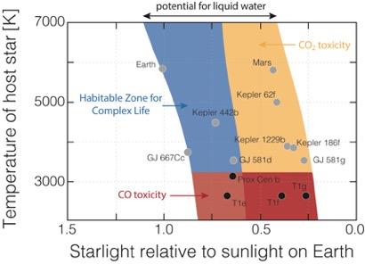
| Astronomy by |
| ||||||||||
|---|---|---|---|---|---|---|---|---|---|---|---|
| Optical telescopes | |||||||||||
| Related | |||||||||||
| Formation | |||||||
|---|---|---|---|---|---|---|---|
| Evolution | |||||||
| Classification |
| ||||||
| Nucleosynthesis | |||||||
| Structure | |||||||
| Properties | |||||||
| Star systems | |||||||
| Earth-centric observations | |||||||
| Lists | |||||||
| Related | |||||||
| Devices |  | |
|---|---|---|
| Models |
| |
| Related | ||
Category:Solar System Category:Planetary science Category:Space science
Life habitable zones[edit]
Life habitable zones
Life habitable zones are the known zones in a solar system to support life. Habitable zones are part of the planetary habitability study.[1] Most zones have a start point at a distance from the host star and then an end point farther from the star. A planet or exoplanet would need to orbit inside the boundary of this zone. With multiple zones, the zones would need to over lap for life. The requirements for bacteria life only would produce a large zones, than for complex life, which would have very narrow zones.[2][3]
The first confirmed exoplanets was discovered in 1992, several planets orbiting the pulsar PSR B1257+12. [4] Since then the list of exoplanets has grown to thousands.[5] Most exoplanets are hot Jupiter planets, that orbit very close the star.[6] Many exoplanets are super earths, that could be a gas dwarfs or large rocky planet. [7]
Unstable stars are young and old stars, or very large or small stars. Unstable stars have changing solar luminosity that changes the size of the habitable zones. Unstable stars also produce extreme solar flares and coronal mass ejections. Solar flares and coronal mass ejections can strip away a planet's atmosphere that is not replaceable. Thus habitable zones require and very stable star like the Sun, at ±0.1% solar luminosity change. [8][9] Finding a stable star, like the Sun, is the search for a solar twin, solar analogs have been found. [10] Stars with an age of 4.6 billion years are at the most stable state. Proper star metallicity is also very important having low luminosity variations.[11][12][13] The Sun is unique as it is metal rich for its age and type, a G2V. The Sun is in its most stable stage currently and has the correct metallicity to make it very stable.[14]
==Life habitable zones==
- Habitable zone (HZ) is the obrit around a star that would allows for liquid water for short period of time ( a given period of time) on a small part of the planet's surface. This zone is a temperature zone, set by the stars radiation and distance from the star. In the Solar System the planet Mars is just at the outer boundary of habitable zone. The planet Venus is at the inner edge Habitable zone, but due to is thick atmosphere has no water. Habitable zone includes planets with elliptical orbits, these planets would orbit into and out of the habitable zone. With an elliptical orbit, a planet moving out of the habitable zone, would have all it water freeze to ice on the outside of the habitable zone and all water would become steam on the inner side. Habitable zone could be defined as place where bacteria, "life", could possibly survive for a short period of time, or called the temperate zone.. Habitable zone is the most quoted zone. [15][16][17]
- Optimistic habitable zone (OHZ) is a zone where liquid surface water could have been on planet in anytime in the past history of the planet. This zone would be large than the habitable zone. Mars is an example of a planet in the optimistic habitable zone, Mars is just beyond the habitable zone today, but had liquid water for a short time span before the Mars carbonate catastrophe, some 4 billion years ago. [18][19]
- Continuously habitable zone (CHZ) is a zone where liquid water persist on its surface of the planet for years. This requires a near circular orbit and a very stable star, as in the Sun and Earth system. This zone is much smaller than the habitable zone. [20][21]
- Conservative habitable zone (CHZ) is zone where liquid surface water is on a planet through most of its history, over a long time span, as on Earth. This would need a greenhouse of the correct gases (like carbon dioxide) and water vapor to maintain the correct temperature with circular orbit. A correct rayleigh scattering would also be needed. [22][23]
- Ultraviolet habitable zone is a zone where the ultraviolet (UV) radiation from a star is not too weak or too strong for existence life. Life needs the correct amount of ultraviolet for synthesis for biochemicals. Set by the amount of ultraviolet radiation from the star, distance from star, the UV wavelength, the age of the star, and atmosphere of the planet. In humans UV is used to produce vitamin D. [24][25] Extreme ultraviolet (EUV) can cause atmospheric loss.[26]
- Photosynthetic habitable zone is zone where both long term liquid water and oxygenic photosynthesis can occur. This set by the star, spectra (color) of the light, and distance from the star. Red dwarf stars have low solar radiation and so a planet would need to be too close to be the photosynthetic habitable zone. A close orbit planet would also be tidally locked. Red dwarf stars are also very unstable. The light intensity, humidity, carbon dioxide level, soil PH, and soil minerals also must be in the range for photosynthesis.[27][28][29][30]
- Tropospheric habitable zone, also called Ozone habitable zone, is zone where the planet would have the correct amount of ozone needed for life. Too much ozone and life would have breathing problems. Too little troposphere ozone would produce biochemical smog. On earth is part of the Ground-level ozone protection. Tropospheric ozone is formed by the interaction of ultraviolet light, with hydrocarbons and nitrogen oxides. [31][32][33]
- Planet rotation rate habitable zone is the zone that a planet's rotation rate is best for life. Slow rotation and the dry/night temperature difference is too great. The rotation rate also changes the planet's reflectivity and thus temperature. Fast rotation rate increases wind speed on the planet. Planet rotation rate has an impact on the planet's clouds and their reflectivity.[34] [35][36]
- Planet rotation axis tilt habitable zone, also called Obliquity habitable zone, is place were a stable rotation axis tilt is held. This is spin axis on the plane of the orbit around the star. Earth's spin axis is tilted 23.5°, this gives seasons, providing snow and ice that can melt to provide water run off in the summer. Obliquity has an major impact on a planet's temperature, thus its habitable zone.[37][38][39][40]
- Tidal habitable zone. Planets too close to the star will be tidally locked. The mass of the star and the distance from the star set the tidal habitable zone. A planet tidally locked has one side of the planet facing the star, this side would be very hot. The face away from the star would be well below freezing. A planet too close to the star will also have tidal heating from the star. Tidal heating can vary the planet's orbital eccentricity. Too far form the star and the planet will not received enough solar heat.[41][42][43]
- Astrosphere habitable zone is the zone which a planet's astrosphere will be strong enough to protect the planet from the solar wind and cosmic rays. The astrosphere must be long lasting to protect the planet. Mars lost its water and most of its atmosphere after the losing its magnetic field and Mars carbonate catastrophe event.[44] [45] Star-Sun's solar wind is made of charged particles, including plasma, electrons, protons and alpha particles. The solar wind is different for each star. Earth's magnetic field is very large and has protected Earth since its formation. [46][47][48]
- Atmosphere electric field habitable zone is place in ambipolar electric field is correct for the planet's electric field to helps ions overcome gravity. The planet's ionosphere must be correct to protect against the lose of the atmosphere. This is addition to a strong magnetic field to protect against the solar wind striping away the atmosphere and water into outer space. [49] [50][51]
- Orbital eccentricity habitable zone is zone in which planets with a near circular orbit. As orbits with eccentricity have the planets move in and out of the habitable zones. [52] In the solar system the grand tack hypothesis gives the theory of the unique placement of the gas giants, the solar system belts and the planets near circular orbits. [53][54] [55]
- Milankovitch cycle habitable zone is zone that gives glaciation periods, ice ages. Milankovitch cycle and ice age have been key is shaping Earth.[56] [57] Life on Earth today is using water melting from the last ice age. The ice ages cannot be too long or too cold for life to survive. Milankovitch cycle has an impact on the planet's obliquity also.[58][59][60]
- Carbon Dioxide habitable zone is the place the planets will have the correct levels of carbon dioxide. The range for carbon dioxide levels is very narrow for life. [61] [62] [63]
- Carbon Monoxide habitable zone is the zone where planets will have low levels of carbon monoxide. Carbon monoxide is poisonous, colorless, odorless, tasteless gas. Carbon monoxide is little less dense than air.[64][65] A planet that has life given atmosphere, cannot have star any dimmer than the Sun, as this would have deadly levels of carbon monoxide. Carbon stars are at the extreme side of deadly carbon monoxide levels.[66][67][68]
- Coupled planet-moon - Magnetosphere habitable zone is the zone that planet's moon and the planet's core produce a strong magnetosphere, magnetic field to protect against the solar wind striping away the planet's atmosphere and water into outer space. Just has Mars had a magnetic field for a sort time, Saied Mighani put forward in 2020, that Earth's Moon had a large magnetosphere for several hundred million years after its formation. The Moon's magnetospheres would have given added protection of Earth's atmosphere as the early Sun was not as stable as it today. In 2020 James Green modeled the coupled planet-moon-magnetosphere habitable zone. The modeling showed a planet–moon magnetospheres that are coupled together would give planet the protection from star stellar wind in the early solar system. In Earth case, the Moon was closer to Earth in the early formation of the solar system, giving added protection. This protection is needed then as the Sun was not as stable then.[69][70][71]
- Pressure-dependent habitable zone is the zone to have the correct atmospheric pressure to have liquid surface water on the planet. With a thin atmospheric pressure the temperature at which water boils is much lower.[72][73] As on Mars today, with its low atmospheric pressure the freezing, evaporation, and boiling point of water is all at the same temperature. Thus liquid water cannot exist on the surface of Mars.[74] [75] Planets with high-pressure atmospheres would have liquid surface water. But life forms would have difficulty with respiratory systems at high-pressure atmospheres.[76][77]
- Galactic habitable zone also called the Galactic Goldilocks zone is the place in a galaxy in which the need parameters to support life to exist. Not all galaxies are able to support life. [78] Cosmic rays at a high level also kill life, as there are health threat from cosmic rays. Galaxies with many stars too close together and without any dust protection, would not have a place for life. Irregular galaxies and other small galaxies do not have enough heavy elements that are needed for life. Elliptical galaxy are full of lethal radiation and lack heavy elements. Large spiral galaxies, like the Milky Way, have the heavy element need for life. [79] Not all Large spiral galaxies are the same, spiral galaxies with too much active star formation can kill the galaxy.[80] [81] Too little star formation and the spiral arms will collapse. [82] Not all spiral galaxies have the correct Galactic ram pressure stripping parameters, too much ram pressure can deplete the galaxy of gas and thus end star formation. The like the Milky Way is barred spiral galaxy. The bar is important to star formation and metallicity of the galaxy's stars and planets. Barred spiral galaxy, must have stable arms with the just right star formation. Bars galaxies are in about 65% of spiral galaxies, but most have too much star formation. [83] A Peculiar galaxy lacks stable spiral arms. [84] Irregular galaxy as too many new stars and lacks heavy elements. [85][86] Unbarred spiral galaxy, not correct star formation and metallicity. [87][88] For long term life on a planet, the spiral arms must be stable for a long period of time, as in the Milky Way. The spiral arms must not be too close to each other, or there will be too much ultraviolet radiation. If the planet moves into or across a spiral arm the orbits of the planets could change, from gravitational disturbances. Movement across a spiral arms also would cause deadly asteroid impacts and high radiation. A galaxy with spiral arm also would have to many asteroid impacts. [89][90][91] The planet must be in the correct place in the spiral galaxy, too close to the center and the center bar's radiation and gravitational force is too great for life. Too far from the center and there is not enough heavy elements for life. The Sun in 28,000 light years from the center bar in the galactic goldilocks zone. At this distance the Sun revolves in the galaxy at the same rate as the spiral-arm rotation.[92][93][94]
- Habitable Zone for Complex Life (HZCL), would be the place that all the life habitable zones overlap for a long period of time, as in the Solar system. Other factors would included: very stable stars with correct color, stable asteroid belts; gas giant planets to protect the life on the planet from large asteroids and comets; all planets having near circular orbits; large moon to stabilize the planet, correct planet size; correct planet core; life forms that change with the star's brightness; plate tectonics; carbon cycle; stable water cycle; correct land to ocean area; correct atmospheric pressure and correct atmospheric gases. [95][96][97][98] Because research has not found other very stable stars (solar twin) or earth like exoplanets (Earth twin), the Rare Earth hypothesis as been gaining more evidence. [99]The list of habitable zones for complex life has grown longer as more knowledge of the universe, galaxies and the solar system are gained.[100][101][102][103]
==Life==
Life on Earth is carbon-based There are theories that life could be based on other elements in the periodic table. [104] Other elements proposed have been silicon, boron, arsenic, ammonia, methane and others. As more research as been done on life on Earth, it has been found that only carbon's organic molecules have the complicity and stability to form life.[105][106][107] Carbon properties allows for complex chemical bonding that produces covalent bonds needed for organic chemistry. Carbon molecules are lightweight and relatively small in size. Carbon's ability to bond to oxygen, hydrogen,nitrogen, phosphorus, and sulfur (called CHNOPS) is key to life.[108] [109][110]
==See also==
*Exoplanet orbital and physical parameters
*Habitability of natural satellites - water on a moon
*Habitability of yellow dwarf systems - water on yellow dwarf star
*Habitability of red dwarf systems - water on red dwarf star
*Planetary habitability in the Solar System - water in our Solar System
*Habitability of binary star systems - water on binary stars
*Habitability of F-type main-sequence star systems - water on F-type star
*Superhabitable planet - a hypothetical exoplanet
==References==
- ^ https://www.spacedaily.com/news/extrasolar-99m.html
- ^ https://www.nasa.gov/universe/new-discovery-shows-habitable-zone-for-complex-life-is-much-more-narrow-than-original-estimates/
- ^ https://phys.org/news/2019-03-complex-life-require-narrow-habitable.html
- ^ Wolszczan, A.; Frail, D. A. (1992). "A planetary system around the millisecond pulsar PSR1257 + 12". Nature. 355 (6356): 145–147. Bibcode:1992Natur.355..145W. doi:10.1038/355145a0. S2CID 4260368.
- ^ https://exoplanetarchive.ipac.caltech.edu/docs/counts_detail.html
- ^ http://users.auth.gr/~voyatzis/Exoplanets/voyatzis_Hipparchos.htm
- ^ Valencia, V.; Sasselov, D. D.; O'Connell, R. J. (2007). "Radius and structure models of the first super-earth planet". The Astrophysical Journal. 656 (1): 545–551. arXiv:astro-ph/0610122. Bibcode:2007ApJ...656..545V. doi:10.1086/509800. S2CID 17656317.
- ^ https://iopscience.iop.org/article/10.3847/2041-8213/abd93a
- ^ https://www.astronomy.com/science/is-earth-the-only-goldilocks-planet/
- ^ NASA, Science News, Solar Variability and Terrestrial Climate, Jan. 8, 2013
- ^ University of Nebraska-Lincoln astronomy education group, Stellar Luminosity Calculator
- ^ National Center for Atmospheric Research, The Effects of Solar Variability on Earth's Climate, 2012 Report
- ^ Most of Earth’s twins aren’t identical, or even close!, by Ethan on June 5, 2013
- ^ https://astrobiology.nasa.gov/news/galactic-habitable-zones/
- ^ https://science.nasa.gov/learn/heat/big-ideas/big-idea-2-1/
- ^ https://exoplanets.nasa.gov/resources/2255/what-is-the-habitable-zone/
- ^ https://www.esa.int/Science_Exploration/Space_Science/Plato/Planets_in_the_habitable_zone
- ^ https://astrobites.org/2022/03/21/continuous-habitable-zone-2/
- ^ https://exoplanets.nasa.gov/news/1720/second-earth-sized-world-found-in-systems-habitable-zone/
- ^ https://www.e-education.psu.edu/astro801/content/l12_p4.html
- ^ https://astrobites.org/2022/03/21/continuous-habitable-zone-2/
- ^ https://astrobites.org/2022/03/21/continuous-habitable-zone-2/
- ^ https://www.astronomy.com/science/is-earth-the-only-goldilocks-planet/
- ^ https://arxiv.org/abs/2303.16229
- ^ https://veradobos.webnode.page/research/habitable-zones/
- ^ https://iopscience.iop.org/article/10.3847/2041-8213/abd93a
- ^ https://iopscience.iop.org/article/10.3847/2041-8213/acccfb
- ^ https://www.astronomy.com/science/a-new-place-to-look-for-alien-life-the-photosynthetic-habitable-zone/
- ^ https://arxiv.org/abs/2301.13836
- ^ N.H. Sleep “Tectonics and the photosynthetic habitable zone” American Geophysical Union, Fall 2009, abstract #B11E-03
- ^ https://iopscience.iop.org/article/10.3847/1538-4357/ab1d52
- ^ https://earth-planets-space.springeropen.com/articles/10.1186/s40623-016-0461-x
- ^ https://www.sciencedirect.com/topics/earth-and-planetary-sciences/photochemical-smog
- ^ Jun Yang et al., “Strong Dependence of the Inner Edge of the Habitable Zone on Planetary Rotation Rate,” Astrophysical Journal Letters 787, no. 1, May 20, 2014, id. L2, doi:10.1088/2041-8205/787/1/L2.
- ^ https://phys.org/news/2014-08-rotation-planets-habitability.html
- ^ https://baas.aas.org/pub/2021n3i0603/release/1
- ^ http://hyperphysics.phy-astr.gsu.edu/hbase/Astro/orbtilt.html
- ^ https://www.sciencealert.com/an-axial-tilt-may-be-crucial-to-the-emergence-of-complex-life-in-the-universe
- ^ https://phys.org/news/2021-07-goldilocks-planets-tilt-complex-life.html
- ^ Gregory S. Jenkins, “Global Climate Model High-Obliquity Solutions to the Ancient Climate Puzzles of the Faint-Young Sun Paradox and Low-Altitude Proterozoic Glaciation,” Journal of Geophysical Research: Atmospheres 105, March 2000, page 7357-70
- ^ https://iopscience.iop.org/article/10.3847/2041-8213/acbe44
- ^ https://eos.org/features/tidally-locked-and-loaded-with-questions
- ^ https://www.sciencedaily.com/releases/2011/02/110224091735.htm
- ^ Vladimir S. Airapetian, “Space Weather Affected Habitable Zones around Active Stars,” AASTCS5 Radio Exploration of Planetary Habitability, Proceedings of the Conference, May 7–12, 2017 in Palm Springs, CA, published in the Bulletin of the American Astronomical Society 49, no. 3, id. 101.05
- ^ David S. Smith and John M. Scalo, “Habitable Zones exposed: Astrosphere Collapse Frequency as a Function of Stellar Mass,” Astrobiology 9, September 2009, page: 673-81.
- ^ Time History of the Martian Dynamo from Crater Magnetic Field Analysis Journal of Geophysical Research: Planets 118, no. 7 (July 2013), by Robert J. Lillis et al., page 1488–1511
- ^ Timing of the Martian Dynamo Nature 408, by G. Schubert, C. T. Russell, and W. B. Moore, December 7, 2000: page 666–667
- ^ Langlais, Benoit; Thébault, Erwan; Houliez, Aymeric; Purucker, Michael E.; Lillis, Robert J. (2019). "A New Model of the Crustal Magnetic Field of Mars Using MGS and MAVEN". Journal of Geophysical Research: Planets. 124 (6): 1542–1569. Bibcode:2019JGRE..124.1542L. doi:10.1029/2018JE005854. ISSN 2169-9100. PMC 8793354. PMID 35096494.
- ^ Glyn A. Collinson et al., “The Electric Wind of Venus: A Global and Persistent ‘Polar Wind’-Like Ambipolar Electric Field Sufficient for the Direct Escape of Heavy Ionospheric Ions,” Geophysical Research Letters 43, no. 12 (June 28, 2016): 5926–34, doi:10.1002/2016GL068327
- ^ Glyn Collinson et al., “Electric Mars: The First Direct Measurement of an Upper Limit for the Martian ‘Polar Wind’ Electric Potential,” Geophysical Research Letters 42, no. 21 (November 16, 2015): 9128–34, doi:10.1002/2015GL065084
- ^ https://www.ucl.ac.uk/news/2016/jun/strong-electric-wind-strips-planets-oceans-and-atmospheres
- ^ https://exoplanets.nasa.gov/resources/99/eccentric-habitable-zones/
- ^ Zubritsky, Elizabeth. "Jupiter's Youthful Travels Redefined Solar System". NASA. Retrieved 4 November 2015.
- ^ Beatty, Kelly (16 October 2010). "Our "New, Improved" Solar System". Sky & Telescope. Retrieved 4 November 2015.
- ^ Sanders, Ray (23 August 2011). "How Did Jupiter Shape Our Solar System?". Universe Today. Retrieved 4 November 2015.
- ^ https://www.usgs.gov/special-topics/water-science-school/science/ice-snow-and-glaciers-and-water-cycle
- ^ Russell Deitrick et al., “Exo-Milankovitch Cycles. I. Orbits and Rotation States,” Astronomical Journal 155, no. 2, January 16, 2018, id. 60, doi:10.3847/1538-3881/aaa301
- ^ Russell Deitrick et al., “Exo-Milankovitch Cycles. II. Climates of G-Dwarf Planets in Dynamically Hot Systems,” Astronomical Journal 155, no. 6, June 4, 2018, id. 266, doi:10.3847/1538-3881/aac214
- ^ https://www.space.com/milankovitch-cycles
- ^ https://climate.nasa.gov/news/2948/milankovitch-orbital-cycles-and-their-role-in-earths-climate/
- ^ Hans O. Pörtner, Martina Langenbuch, and Anke Reipschläger, “Biological Impact of Elevated Ocean CO2 Concentrations: Lessons from Animal Physiology and Earth History,” Journal of Oceanography 60, no. 4, August 2004, page 705–18, doi:10.1007/s10872-004-5763-0
- ^ Zaher S. Azzam et al., “The Physiological and Molecular Effects of Elevated CO2 Levels,” Cell Cycle 9, no. 8, April 20, 2010, page 1528–32, doi:10.4161/cc.9.8.11196
- ^ Kris Permentier et al., “Carbon Dioxide Poisoning: A Literature Review of an Often Forgotten Cause of Intoxication in the Emergency Department,” International Journal of Emergency Medicine 10 (April 4, 2017): id. 14, p. 1, doi:10.1186/s12245-017-0142-y
- ^ https://physicsworld.com/a/toxic-gases-in-habitable-zone-could-hinder-emergence-of-alien-life/
- ^ Hui Liu et al., “Association of Short-Term Exposure to Ambient Carbon Monoxide with Hospital Admissions in China,” Scientific Reports 8 (September 6, 2018): id. 13336, doi:10.1038/s41598-018-31434-1
- ^ https://iopscience.iop.org/article/10.3847/1538-4357/ab1d52
- ^ https://science.nasa.gov/missions/hubble/hubble-views-striking-carbon-star-in-colorful-cluster/
- ^ https://www.nature.com/articles/537140b
- ^ https://iopscience.iop.org/article/10.3847/2041-8213/abd93a
- ^ https://www.aanda.org/articles/aa/full_html/2014/10/aa24323-14/aa24323-14.html
- ^ https://iopscience.iop.org/article/10.3847/2041-8213/abd93a#apjlabd93abib29
- ^ https://wwwuser.oats.inaf.it/astrobiology/planhab/
- ^ https://iopscience.iop.org/article/10.1088/0004-637X/767/1/65
- ^ "Mars & Comets - NASA". mars.nasa.gov.
- ^ https://www.ncbi.nlm.nih.gov/pmc/articles/PMC7191838/
- ^ https://www.medicinenet.com/how_does_barometric_pressure_affect_humans/article.htm
- ^ https://pubmed.ncbi.nlm.nih.gov/29262037/
- ^ https://www.science.org/content/article/complex-life-may-be-possible-only-10-all-galaxies. Many galaxies has life killing events like gamma-ray burst. About 90% of galaxies have long and frequent gamma ray bursts, thus no life.
- ^ https://www.discovermagazine.com/the-sciences/which-galaxies-are-best-suited-for-the-evolution-of-alien-life
- ^ https://brighterworld.mcmaster.ca/articles/whats-killing-galaxies-large-survey-reveals-how-star-formation-is-shut-down-in-extreme-regions-of-the-universe/
- ^ https://nrc.canada.ca/en/stories/whats-killing-galaxies-large-survey-reveals-how-star-formation-shut-down-extreme-regions-universe
- ^ https://www.sciencedaily.com/releases/2020/05/200501120104.htm
- ^ https://www.aanda.org/articles/aa/full_html/2016/11/aa28750-16/aa28750-16.html
- ^ https://academic.oup.com/mnras/article/286/4/969/978417
- ^ https://ned.ipac.caltech.edu/level5/Hunter/Hunter1.html
- ^ https://www.letstalkstars.com/irregular-galaxy-a-unique-collections-of-stars/
- ^ https://www.aanda.org/articles/aa/full_html/2016/11/aa28750-16/aa28750-16.html
- ^ https://academic.oup.com/mnras/article/431/3/2560/1077078
- ^ Si-Yue Yu and Luis C. Ho, “On the Connection between Spiral Arm Pitch Angle and Galaxy Properties,” Astrophysical Journal 871, no. 2, February 1, 2019, id. 194, doi:10.3847/1538-4357/aaf895
- ^ https://www.scientificamerican.com/article/what-process-creates-and/
- ^ https://www.scientificamerican.com/article/the-milky-ways-spiral-arms-may-have-carved-earths-continents/
- ^ https://www.astro.umd.edu/~miller/teaching/honr/suppl02.pdf
- ^ https://astrobiology.nasa.gov/news/galactic-habitable-zones/
- ^ https://medium.com/predict/why-different-types-of-galaxies-may-affect-the-development-of-life-32d705e0023b
- ^ https://iopscience.iop.org/article/10.3847/1538-4357/ab1d52
- ^ https://www.nature.com/articles/s41598-020-64436-z
- ^ https://www.nasa.gov/universe/new-discovery-shows-habitable-zone-for-complex-life-is-much-more-narrow-than-original-estimates/
- ^ https://phys.org/news/2019-03-complex-life-require-narrow-habitable.html
- ^ https://www.npl.washington.edu/av/altvw102.html
- ^ Gribbin, John (2011). Alone in the Universe: Why our planet is unique. Wiley
- ^ Ward, Peter D.; Brownlee, Donald (2000). Rare Earth: Why Complex Life is Uncommon in the Universe. Copernicus Books (Springer Verlag). ISBN 978-0-387-98701-9.
- ^ Gonzales, Guillermo; Richards, Jay W (2004). The Privileged Planet. Regnery Publishing, Inc.
- ^ https://davidwaltham.com/lucky-planet/
- ^ "Knowledge reference for national forest assessments - modeling for estimation and monitoring". www.fao.org. Archived from the original on 13 January 2020. Retrieved 20 February 2019.
- ^ Allison, Steven D.; Vitousek, Peter M. (1 May 2005). "Responses of extracellular enzymes to simple and complex nutrient inputs". Soil Biology and Biochemistry. 37 (5): 937–944. doi:10.1016/j.soilbio.2004.09.014. ISSN 0038-0717.
- ^ "Astrobiology". Biology Cabinet. 26 September 2006. Retrieved 17 January 2011.
- ^ "Polycyclic Aromatic Hydrocarbons: An Interview With Dr. Farid Salama". Astrobiology magazine. 2000. Archived from the original on 20 June 2008. Retrieved 20 October 2008.
- ^ Lipkus, Alan H.; Yuan, Qiong; Lucas, Karen A.; et al. (2008). "Structural Diversity of Organic Chemistry. A Scaffold Analysis of the CAS Registry". The Journal of Organic Chemistry. 73 (12). American Chemical Society (ACS): 4443–4451. doi:10.1021/jo8001276. PMID 18505297.
- ^ Molnar, Charles; Gair, Jane (14 May 2015). "2.3 Biological Molecules". Introduction to the Chemistry of Life – via opentextbc.ca.
- ^ Education (2010). "CHNOPS: The Six Most Abundant Elements of Life". Pearson Education. Pearson BioCoach. Archived from the original on 27 July 2017. Retrieved 10 December 2010.
Most biological molecules are made from covalent combinations of six important elements, whose chemical symbols are CHNOPS. ... Although more than 25 types of elements can be found in biomolecules, six elements are most common. These are called the CHNOPS elements; the letters stand for the chemical abbreviations of carbon, hydrogen, nitrogen, oxygen, phosphorus, and sulfur.
Category:Planetary habitability
[edit]
Pacific Ocean Areas Pacific War Naval Bases


US Pacific war Naval Bases were a number of United States Navy bases in Pacific Ocean during World War II to support the island hoping Pacific war efforts of the allied nations fighting the Empire of Japan from 1941 to 1945.
==History==
After World War I, in which Japan fought on the Allied side, Japan took control of German bases in China and the Pacific. In 1919, the League of Nations approved Japan's mandate over the German islands north of the equator. The United States did not want any mandates and was concerned with Japan's aggressiveness. As such, the Wilson Administration transferred 200 Atlantic warships to the Pacific Fleet in 1919.[1] The Port of San Diego, not yet developed, was too shallow to handle the battleships, so San Pedro Submarine Base became a Naval Base on August 9, 1919. San Pedro Submarine Base and Long Beach became fleet anchorage for the 200 ships. In 1940, President Roosevelt had the fleet at San Pedro moved and stationed at Honolulu's Naval Base Pearl Harbor due to Japanese war actions in China. While the United States was committed to Neutrality in the 1930s, Japan's aggression against China had caused concern. On December 29, 1934, President Franklin D. Roosevelt signed Executive Order 6935 transferring the Johnston Atoll and Wake Island to the US Navy under the 14th Naval District, Pearl Harbor, in order to establish an air station and refuge - breeding ground for native birds. On 9 January 1941, the transport ship USS William Ward Burrows (AP-6) arrived at Wake Island with a crew of the Contractors Pacific Naval Air Bases, to start construction of the Naval Air Station Wake.
On February 14, 1941, President Roosevelt signed Executive Order 8682 to create naval defense areas in the central Pacific US territories. [2] The order called for the formation of :
- Palmyra Island Naval Defensive Sea Area, with Palmyra Island Naval Airspace Reservation
- Johnston Island Naval Defensive Sea Area, with Johnston Island Naval Airspace Reservation
- Midway Island Naval Defensive Sea Area, with Midway Island Naval Airspace Reservation
- Wake Island Naval Defensive Sea Area, with Wake Island Naval Airspace Reservation
- Kingman Reef Naval Defensive Sea Area, with Kingman Reef Naval Airspace Reservation".
On the Battle of the Atlantic side, Roosevelt had already signed on September 2, 1940, the Destroyers-for-bases deal with the United Kingdom. Given the US Navy bases in the Caribbean and [[Newfoundland]]: Naval Base Trinidad and Naval Station Argentia.
Before the United States entered World War II, the United States Armed Forces began preparing for war by building up naval bases in the Pacific. Before World War II the US had Naval bases in US Territories: Hawaii, American Samoa, Naval Base Guam and the Philippines. The United States entered World War II after Hawaii's Pearl Harbor was attacked on December 7, 1941. At the same time, Guam was invaded and occupated. Also at the same time, Wake Island was invaded and the Philippines were invaded. The Naval bases in Guam, Wake and Philippines were lost to Japan. On 6 June 1942 a small US Navy weather station in Kiska, Aleutian, Alaska was lost also. Wake was not reclaimed till after the war and the other bases were retaken during the war.[3]
To fight the Pacific War a vast amount of supplies were needed to support the thousands of US Troops in the Pacific. United States put into place the Emergency Shipbuilding program, which built a vast number of Merchant Navy ships and US Navy ships in a short time span. [4][5] Most of the Naval bases and Army airfields were built by the US Navy Construction Battalion, called Seabee.[6] The Seabee of World War II had ships, training, heavy equipment and Advance Base Construction Depots (ABCD) with the supplies needed to built new advance bases across the Pacific. Combat Seabee were also used to form beachhead ports in amphibious landings. Seebee Construction Battalion Maintenance Units were used to operate Naval ports and airbases.[7][8]
During World War II the Navy performed different roles in the Pacific war, the main roles were:
- Naval Battles[9]
- Supply Chain, and logistic support
- Stopping Japan's Supply Chain (PT Boats and submarines
- Support of landings - land battles
- Anti-submarine warfare
- Air Reconnaissance and sea Reconnaissance
- Search and rescue or aircrews and seamen
- Weather forecasting
- Code breaking
Most troops in the US Armed Forces are in the support role of the small group that goes into combat zones. The supply chain is one of the largest groups of support troops. [10][11]
==Major Bases==
Central Pacific Area
- Naval Base Hawaii
- Naval Base Panama Canal Zone
- Naval Air Facility Midway Island
- Naval Base Marshall Islands
- Naval Base Majuro, floating base with land
- Naval Base Kwajalein
- Naval Base Eniwetok, floating base with land
- US Naval Base Marianas
- Naval Base Guam
- Tinian Naval Base, Northern Mariana
- Naval Base Saipan, Northern Mariana
- US Naval Base Carolines
- Naval Base Ulithi, Caroline Islands, floating base with land
- Peleliu Naval Base
- Naval Base Kossol Roads floating base
- Naval Base Iwo Jima
- Naval Base Okinawa
South Pacific Area
- Naval Base Espiritu Santo
- Naval Base Fiji
- US Naval Base Solomons
- Naval Base Gilbert Islands
- Naval Base Samoa
- Naval Base Noumea, New Caledonia
Southwest Pacific Area
- US Naval Base New Guinea
- Manus Naval Base, Bismarck Archipelago, Admiralty Islands Base
- US Naval Base Australia
- US Naval Base New Zealand
- US Naval Base Philippines
- Naval Base Borneo - Naval Base Dutch East Indies
South East Asia Command
South East Asia Command working with Australian forces in the South-East Asian theatre and China Burma India Theater: Naval Base Kandy in Ceylon
- Naval Base Calcutta at Calcutta shared with British and India FPO#918
- Naval Base Madras, at Madras India FPO# 918, Box M
- Naval Base Rangoon, at Rangoon, Burma FPO#918, Box R
- Northern islands of Sumatra
North Pacific Area
- Aleutian Islands: 3 June 1942 – 24 August 1943, the Aleutian Islands campaign
Naval Base Merauke,
Naval Base Woodlark Island
Naval Base Finschhafen
Naval Base Alexishafen
Naval Base Banika Island
Naval Base Puerto Princesa
Roebuck Bay Seaplane Base
Naval Base Funafuti
Naval Base Abemama
Naval Base Kwajalein,
Naval Base Majuro,
==Types of Naval bases==
- Naval Service Squadron a Floating Naval Base
- Fleet anchorage for ship staging, natural harbor or man-made sea port
- Submarine Base, land or Submarine tender
- Naval Airbase
- Naval Aircraft repair base - Carrier Aircraft Service Units
- Naval Repair depot land and Repair ship
- Seaplane base, land or Seaplane tender
- Destroyer base, land or Destroyer tender
- Wooden_boats_of_World_War_II#Landing_craftAmphibious craft repair - support
- Naval Hospital, land, Hospital ship or Mobile Naval Hospital
- PT boat base, land or PT repair - support ship
- Submarine chaser base land or repair - support ship
- Crash boat base, search and rescue boats
- Refueling, land tank farm or replenishment oiler
- Supply depot, land or stores ships
- Ammunition depot, land or Ammunition ship
- Recreation center for R&R
- Staging Barracks, land or Barracks ship
- Anti-aircraft warfare training base
- Reconnaissance
- Amphibious landing training
- Lighter-Than-Air Station, Blimp port
- Naval Mine Laying
- Net Laying in support of bases and ship
==USO==

With thousands of Troops stationed and fighting across the Pacific, the USO was an important part of moral boosting for many Troops. The United Service Organizations (USO) was founded in 1941 to lift the morale of our military and nourish support on the home front. The USO was formed by having existing organizations work together to support the Troops, the first groups were: Salvation Army, Young Men’s Christian Association, Young Women’s Christian Association, National Catholic Community Services, National Travelers Aid Association and the National Jewish Welfare Board. USO Hawaii serve all the military bases in Hawaii. [12][13] USO operated Clubs in non-combat base like Hawaii. [14][15]
One of the major events during World War II was the Bob Hope show. Hope called his 1944 USO World War II military tour of the South Pacific: “Loew’s Malaria Circuit” and “the Pineapple Circuit”. Hope, Jerry Colona, Frances Langford, musician guitarist Tony Romano and Patty Thomas did 150 shows in the two 1/2 months they were on road. Hope and Thomas would do Soft shoe dance together in the show and Thomas would do solo tap dance numbers. Sp the Troops could Patty Thomas tap dance Hope followed her around a microphone. Also on the tour were singer Gale Robbins, musicians June Brenner and Ruth Denas, and comedians Roger Price and Jack Pepper.[16] The tours visited: Naval Base Pearl Harbor Hawaii at the Nimitz Bowl, Naval Base Eniwetok, Naval Base Cairns, Green Islands, Bougainville, Milner Bay, Naval Base Treasury Islands, Naval Base Mios Woendi called Wendy Island, and Naval Base Kwajalein.[17]
== Doolittle Raid==
After the devastating attack at Pearl Harbor the United States needed a moral boot. The answer came in a bold plan to attack the Japan's homeland. The Doolittle Raid was carried out by 16 North American B-25 Mitchell bombers launched from the deck the aircraft carrier, USS Hornet (CV-8) on 18 April 1942. All 16 planes bomber Japan. While know of the planes returned to service, most of the crew did. The raid did cause Japan to divert resources to protecting the homeland. [18][19]
==Code breaking==
Fleet Radio Unit Pacific, also called Station HYPO, was the US Navy's codebreaking unit in Hawaii. The Navy unit was used in breaking Japanese naval codes.[20] The US Navy's Station CAST and Fleet Radio Unit at Naval Base Melbourne was the other unit working on codebreaking. The unit at Naval Base Cavite and Naval Base Manila's Corregidor Island was lost with the fall of the Philippines in 1942. Station HYPO was key in finding the planned attack on Midway in 1942.[21][22]
==Kamikaze ==
As Japan continued to lose ships, planes, occupated lands, and troops, it turned some of its planes and pilots into suicide attack planes. Planes full of bombs and gas tried to crash into US Navy ships. Japan launched about 3,041 kamikaze attacks during World War II, about 19% of kamikaze planes made it to their target. About 7,000 US Navy men were killed in the attacks starting in October 1944 in the Battle of Leyte Gulf. Kamikaze sank 34 Navy ships and damaged 368 others ships. The Merchant Navy lost 6 ships, including ammunition ships that sank with an explosion after kamikaze attack in 1945: SS Canada Victory, SS Hobbs Victory, SS Logan Victory, SS John Burke, and SS Lewis L. Dyche. The US response was an increase of bombings of Japan-held airfields, improved anti-aircraft fire, aircraft defense and Combat air patrol. By the end of the war, Japan was running out of planes and pilots to defend Japan.[23][24]
==Submarine Bases==
Many US Navy submarines were used in the Pacific War. The submarine attacked warships and sank supply ships that were needed by Japan to resupply their many bases in the Pacific. US subs also did reconnaissance patrols, landed guerrilla special forces and search and rescue missions for downed aircrew mem.[25] US submarine had long ranges, but needed to be resupplied with fuel, food, torpedoes and deck gun shells. At submarine bases the Navy had both land ad floating submarine bases. The submarine tenders like the: USS Sperry (AS-12) and USS Sumner (AGS-5) could be stationed in advanced base to supply the submarines. While the submarine was being resupplied, and repaired if needed, crews could have a break (R&R) on tenders and at some bases land recreation centers. [26]
==Destroyer bases==
_with_destroyer_escorts_during_WWII.jpg)
Hundreds of US Navy destroyers were used in the Pacific war. Destroyers were used to protect capital ships like aircraft carriers, battleships and heavy cruisers. Destroyers were used to screen and protect convoy of ships. Destroyers were used to hunt submarines and protect amphibious landings at beaches. Destroyers had anti-aircraft guns, radar, and forward-launched ASW weapons, dual-purpose guns, depth charges, and torpedoes.[27][28] Like the submarines, they needed to be restocked with food, fuel, supplies, and weaponss to keep operational. Both land bases and floating destroyer bases with destroyer tenders were used in the Pacific war. Destroyer tenders could do minor repair work on the ships. Some of destroyer tenders of Pacific war: USS Cascade (AD-16), USS Prairie (AD-15), USS Piedmont (AD-17), USS Yosemite (AD-19), USS Hamul (AD-20), USS Dixie (AD-14), and USS Sierra (AD-18).[29] [30]
==Seaplane bases==


_underway_at_sea,_circa_in_1942_(NH_43513).jpg)
The US Navy operated many seaplane base across the Pacific. Seaplanes did reconnaissance patrols and search, also rescue missions for downed aircrew mem and survivors of sunk ships. The most common seaplanes at the bases were Consolidated PBY Catalina and Martin PBM Mariner. [31]The seaplanes were supported by both land bases and floating base of seaplane tenders. At land bases, a seaplane ramp was constructed so by the seaplane could be taken onto land for repair work more easily. Seaplane tenders and land base had stores to supply: food, fuel, ammo, spare parts. The seaplane tender also had housing and mess halls for the aircrew while the seaplane was being serviced. Seaplane tenders moved to more forward bases as the war progressed. Some of the Pacific War seaplane tender were: USS Corson (AVP-37), USS Hamlin (AV-15), USS Casco (AVP-12), *USS Suisun, USS Chandeleur (AV-10), USS Mackinac (AVP-13), USS Barataria (AVP-33) and USS Chincoteague (AVP-24). [32]
==Crash rescue boats==
crash boats were fast boats use to rescue downed airmen. Often stationed near airfields. By the end of World War II, America had produced 300,000 planes, creating a need to have crash rescue boats stationed around the globe. These boats were fast boats used to rescue pilots, crew and passengers from downed aircraft in search and rescue and air-sea rescue missions. The boats would race out to a crash site and rescue wounded aircrew. Some speed boats built before the war were acquired and converted to be crash boats and many new boats were built. [33][34][35][36] After the war, most were abandoned or destroyed, though a few served in the Korean war (with United States Air Force), while some sold to private and some donated to Sea Scouts. By the Korean war the helicopter had taken the place of the crash boat in rescuing pilots and aircrews.[37][38][39]
==Submarine chaser base==
To help protect the bases and shipping around the base, the Navy had a fleet of submarine chasers. The submarine chasers were supported by a submarine chaser tender ships like the, USS Mindanao (ARG-3). ARG ships also support crash boats and PT Boats. Some of the submarine chasers: USS PC-1137, USS PC-598, USS PC-1136, USS PGM-18, and USS PC-1138.[40][41][42]
==PT Boat Bases===

Many PT Boat Bases were built across the Pacific. PT Boat were wooden boats that were small, fast and able to attack large ships. PT Boats used the same torpedoes as the submarines so the PT-Boats could also operate out of the few Submarine Base. PT Boat also anti-aircraft guns for protection. PT Boats like: PT-20 and Patrol torpedo boat PT-29 were the first to shot at Japan planes in the war. In addtion to the many small PT Boat bases, usually hidden in topical isandls, PT Boats operated off PT Boat Tenders, usually designated: Motor torpedo boat tender, Patrol Craft Tender and Internal combustion engine repair ship [43][44] In 1943 PT Boats wtih Suadron 26, (PT-255 thru PT-264) were stationed at Pearl Harbor. PT Boats had a range of about 500 miles and were armed with four .50-caliber machine guns and four 21-inch torpedo tubes. [45][46]
==Repair bases and depots==
With the vast US Navy Pacific Fleet ships and boats needed regular repair work and damage repair. Some ships were also damaged in typhoons. The repair bases and depots provided the fleet with support to keep ships and subs tactically available in the Pacific War with the repair and supply depot, rather than ships having to return to continental United States. The Navy had built special auxiliary floating drydocks that were able to repair battle damage to even the largest ships and do regular maintenance in the field saving ships trans-pacific travel time for repair. Supply store ships were also at the base with the parts needed to keep the fleet ready. The Navy had a fleet of repair ships able to move to more advance bases as needed, or to help land bases keep up with repair demand. [47] [48] Some of the repair depot ships and crafts: USS AFDB-2, very large auxiliary floating drydock able to repair battleships, USS Richland (YFD-64) and auxiliary floating drydock, USS Oak Ridge (ARDM-1) an Auxiliary floating drydock, USS ARD-1 dry dock, USS Jason (AR-8) a large repair ship, USS Ajax as large repair ship, USS Nestor (ARB-6) repair ship and small craft tender, USS Oceanus (ARB-2) a battle damage repair ship, USS Vestal a large repair ship, USS Mona Island (ARG-9) a repair ship, USS Deliver (ARS-23) a rescue and salvage ship, USS Shackle (ARS-9) a rescue and salvage ship, YRB-34, Floating Workshop. Landing craft repair ships (ARL), like the Achelous-class repair ships, were used to repair Landing craft. Thousands of landing craft were built for World War II these ships supported the Landing craft fleet. Some ships had temporary repairs done in the field and then went to a major base for finial repairs and upgrades, base like: Pearl Harbor Naval Shipyard, Mare Island Naval Shipyard[49] , Hunters Point Naval Shipyard [50] and Puget Sound Naval Shipyard [51][52]
==Carrier Aircraft Service Units==

The US Navy and United States Marine Corps had hundreds of aircraft orating off aircraft carriers and land airbases across the Pacific. To keep the planes airworthy the Navy set up in 1942 aviation training facilities for Carrier Aircraft Service Unit (CASU) at Naval Base Hawaii's Ewa Field, Naval Air Station Kahului and NAS Puunene. Flight crews and air mechanics trained before heading out to the Pacific War. Also at some base, the Navy had shipped in spare planes to replace planes lost. [53] [54]
- Carrier aircraft used during World War II by US Navy: (years used) (number built)
- Douglas TBD Devastator - torpedo bomber (1937-1944) (130)
- Grumman F4F Wildcat - torpedo bomber (1941-1945) (7,885)
- Grumman TBF Avenger - torpedo bomber (1941-1948) (9,839)
- Grumman F6F Hellcat - fighter-bomber (1942-1947) (12,275)
- Curtiss SB2C Helldiver - dive bomber (1943-1953) (7,140)
- Vought F4U Corsair - fighter-bomber (1943-1953) (12,571)
- A few North American T-6 Texan - Land Trainer aircraft were stationed at some bases. Aircraft carriers of World War II would have 70 to 100 planes on board. Escort carriers would carry 20 to 30 planes. US Navy and US Marines also operate the planes from land bases.
Spare aircraft parts were stocked at both land depots and on aircraft stores ships like the, USS Supply (IX-147), USS Fortune (IX-146) and USS Grumium (AK-112).[55]
==Merchant Navy==
To supply both the United States Navy, United States Army, United States Marine Corps, United States Army Air Forces, United States Coast Guard and the US Allied Nations a massive amount of supplies needed to new transport to the base across the Pacific Ocean. The World War II United States Merchant Navy was the largest civilian Navy in the world. The demand for cargo and fuel was very high. [56][57] American steamship companies chartered ships from the Maritime Commission and War Shipping Administration to meet the demand. Many United States Merchant Marine ships were newly built in the Emergency Shipbuilding Program, other ships were older World War I ships that were put back in service, or private ships acquired under Emergency war requisitions. The Merchant Navy operated in the Pacific War and European war.[58][59] Merchant Navy at its peak had over 215,000 men operating the Merchant Navy ships. The losses by the end of the war was 8,651 crew deaths. Merchant Marine were killed at a per capita rate much higher than those of the combined United States Armed Forces.[60] Merchant Navy crews were killed at a rate of 1 in 26 (US Navy rate was 1 in 114).[61]The Emergency Shipbuilding Program built many types of ships to support the war. The most numerous ships were the 2,710 cargo Liberty ships.[62] Liberty ships were built between 1941 and 1945, with a new module assembly process so that about three ships were built every two days.[63] Victory ships were a faster replacement ship for the Merchant Navy. Between 1944 and 1946, 531 Victory ships were built, with some to the US Navy and 414 to the Merchant Navy.[64][65] The Merchant Navy also operated: other cargo ships like: Type N3, Type C1, Type C2, Type C3, and the largest Type C4. Merchant Navy operated tanker ships like: T1 tanker, T2 tanker and the largest T3 Tankers for fuel oil, aviation gasoline, and Diesel fuel. Merchant Navy operated special ships like: Type L6, called Lakers, Type P1 small Passenger ships, Type P2 Passenger, Type R, refrigerated cargo ships, Type B Barges and Type V Tugboats. The Merchant Navy operated Troopships, both passenger ships and cargo ships coverted to troopships. For World War II 97 Victory ships temporarily were converted to troopship.[66] By the end of the war over 11,000 ships were under the control of the War Shipping Administration.[59][67][68]
==Pacific War casualties ==
Total casualties in the Pacific War was about 36 million, 50% of all casualties of the World War II. The US Navy lost 31,157 troops killed in action out of a total of 62,858 combat casualties in the Pacific War. Almost a third of all Allied prisoners of war died in Japanese POW camps by the time the war ended. Japan , a reflection of the brutal treatment they received from their captors. Commonwealth forces actually suffered more deaths in Japanese POW camps than in combat. The British lost 50,016 prisoners of war in southeast Asia, the Australian 21,726, and the Indians 68,890. The American forces lost 21,580 prisoners of war, most of them in the Philippines. United States wounded troops had a higher survival rate than other nations, due to the many Naval and Army base field hospitals in operation. Total casualties in the Pacific War by nation: ([69]
| Nation | Killed or missing | Wounded | Prisoners of war | Civilian deaths |
|---|---|---|---|---|
| United States | 111,606 | 253,142 | 21,580 | |
| Australia | 9,470 | 13,997 | 21,726 | |
| China | 4,000,000 | 3,000,000 | 18,000,000 | |
| India | 6,860 | 24,200 | 68,890 | 2,000,000 |
| Japan | 1,740,000 | 94,000 | 414,402 | 393,400 |
| Netherlands East Indies | 37,000 | 4,000,000 | ||
| Philippines | 1,000,000 | |||
| United Kingdom | 5,670 | 12,840 | 50,016 |
==POWs==
Japan's treatment of POWs and civilians was very poor. Many were exhausted from hunger and disease. Many deaths were caused by the diversion of food, such as rice, to Japanese troops from the local populations. Between 4 and 10 million Indonesians from the Dutch East Indies were turned into Japan's forced labourers, called romusha. Four million died in the Dutch East Indies as a result of famine and forced labour.[70][71]International Red Cross packages were not distributed to POWs.[72][73] In the Dutch East Indies there were both massacres and executions of POWs:[74][75]
- Bangka Island massacre
- Balikpapan massacre
- Laha massacre
- Rawagede massacre
- Pontianak incidents
- Sandakan Death Marches
- Parit Sulong Massacre
- Karoenga massacre on Tarakan Island in January 1942, coastal battery crew
- Menado, Celebes Island, January 1942, executions of 12 POWs
- Kertosono, Java Island, March 1942 executions of 9 POWs, Dutch marines
- Tjiater, Java Island, March 6, 1942 executions of 72 POWs
- Kalidjati Airfield massacre, Java Island, March 1942, British RAF ground personnel killed
- Samarinda, Borneo Island, March 1942 at airfield Samarinda II 13 KNIL Army POWs shot
- Long Nawang, Borneo Island, August 1942 Japn executed many refugees in Kampong, including all crew members from a Glenn Martin bomber and three crew-members from Dornier seaplane.
- Koetaradja II, Sumatra Island, March 1942, 56 POWs shot and dumped at sea.
- Bireuen, Sumatra Island, March 1942, 18 POWs shot at bridge. Four escaped to tell about the 18.
- Cargo ship Langkoeas lifeboats attacked by I-158
- Tanker Augustina massacre, Western Java Sea, 1942, lifeboat machine-gunned, only 2 survived.[76]
==End of War==
The United States' planned invasion of Japan, was called Operation Downfall, the invasion was being prepared, as the atomic bombs were top secret in the Manhattan Project. The test of the first atomic bomb, at the Trinity site was successful. The planned invasion was not needed with the Surrender of Japan on 2 September 1945, after the atomic bombings of Hiroshima and Nagasaki. At the end of the war, the US Navy started Operation Magic Carpet, to bring the millions of troops overseas home.
==See also==
 *Military history of the United States during World War II
d
==References==
- ^ Cathal J. Nolan, et al. Turbulence in the Pacific: Japanese-U.S. Relations during World War I (2000)
- ^ https://www.archives.gov/federal-register/codification/executive-order/08682.html
- ^ https://www.doi.gov/oia/press/op-ed-us-territories-not-states-bear-scars-world-war-ii
- ^ Jaffee, Capt. Walter W., The Lane Victory: The Last Victory Ship in War and in Peace, 2nd ed., p. 14, The Glencannon Press, Palo Alto, CA, 1997.
- ^ MARAD, Victory Ship, U.S. Maritime Commission design type VC2-S-AP2
- ^ Rogers, J. David. "USN Seabees During World War II" (PDF). Missouri University of Science and Technology. p. 8. Retrieved 18 October 2017.
- ^ "Chapter VI: The Seabees". Building the Navy's Bases in World War II: History of the BuDocks and the CEC 1940–1946. Vol. I. Washington, DC: U.S.GPO. 1947. Retrieved 18 October 2017 – via HyperWar.
- ^ 37th Seabees cruisebook, Seabee Museum Archives website, Port Hueneme, CA, Jan. 2020, p. 12-16
- ^ U.S. Navy Surface Battle Doctrine and Victory in the Pacificusnwc.edu
- ^ https://www.thesoldiersproject.org/what-percentage-of-the-military-sees-combat/
- ^ Beans, Bullets, and Black Oil - The Story of Fleet Logistics Afloat in the Pacific During World War II by Rear Adm. Worrall Reed Carter, The Honorable Dan A. Kimball, Admiral Raymond A. Spruance
- ^ USO Hawaiihawaii.uso.org
- ^ About USO Hawaiiuso.org
- ^ Inside the Archives: Down Honolulu Way: The USO and The Navy in Hawaii 1942-1947ijnhonline.org
- ^ USO Clubshistorichawaii.org
- ^ Bob Hope Tour 1944eaglehorse.org
- ^ Patty Thomas gallery loc.gov
- ^ "Aftermath: How the Doolittle Raid Shook Japan". 27 July 2015. Archived from the original on 19 April 2018. Retrieved 19 April 2018.
- ^ "James H. Doolittle". 9 November 2009. Archived from the original on 31 July 2022. Retrieved 31 July 2022.
{{cite web}}:|archive-date=/|archive-url=timestamp mismatch; 24 March 2022 suggested (help) - ^ "US Codebreakers In The Shadow Of War"airvectors.net
- ^ Naval Supplementary Radio Station Melbourne Australia stationhypo.com
- ^ Fleet Radio Unit, Melbournenavycthistory.com
- ^ Downfall: The End of the Imperial Japanese Empire By Richard B. Frank
- ^ Zaloga, Steve (21 June 2011). Kamikaze: Japanese Special Attack Weapons 1944–45. New Vanguard. Osprey Publishing. p. 12. ISBN 978-1849083539.
- ^ Blair, Clay, Jr. Silent Victory (Bantam, 1947), pp.508, 521–2, 568, 574, 576, 609, 646, 724, 745–6, 784, 806, 818, 825, 827, 829, 842, 865–6, & 868–9.
- ^ Building the Navy's Bases in World War II, Volume II (Part III, Chapter 26)US Navy
- ^ Fitzsimmons, Bernard: The Illustrated encyclopedia of 20th century weapons and warfare. Columbia House, 1978, v. 8, page 835
- ^ Smith, Charles Edgar: A short history of naval and marine engineering. Babcock & Wilcox, ltd. at the University Press, 1937, page 263
- ^ US naval base at Ulithi laffey.org
- ^ Cooney, David M. (1980). Ships, Aircraft and Weapons of the United States Navy. Washington, D.C.: United States Government Printing Office.
- ^ Ulithi seaplane basepacificwrecks.com
- ^ Naval Base Ulithimicroworks.net
- ^ "Design & Construction of Boats". Uscrashboats.org. 25 July 1944. Retrieved 23 February 2021.
- ^ "US Army Rescue Boats P". shipbuildinghistory.com.
- ^ "Boats of the United States Navy". Maritime.org. Retrieved 23 February 2021.
- ^ "The Forgotten Ones: 5 Fascinating Stories from the Korean War". 27 July 2019.
- ^ Jordan, Margaret. "1943: The Development of Air-Sea Rescue".
- ^ "Memorial Park". www.nationalmuseum.af.mil.
- ^ "The birth of modern Air-Sea Rescue". 28 April 2012.
- ^ Naval Base Ulithi Submarine chaser dp.la
- ^ SC-1372 navsource.org
- ^ USS Mindanao navsource.org
- ^ Bulkley, Robert Johns (1962). Bulkley. p. 79.
- ^ The Navy's Gallant Sentriesusni.org
- ^ PT Boats At Pearl Harbor On 7 December 1941ptboatworld.com
- ^ PT-20navsource.org
- ^ Instances of Use of United States Armed Forces Abroad, 1798-2020
- ^ "World War II Database - Leslie Gehres". 31 July 2015.
- ^ Adams, George R. (1 December 1974). "Mare Island Naval Shipyard" (pdf). National Register of Historic Places – Inventory Nomination Form. National Park Service. Retrieved 18 May 2012.
- ^ "Defer Hunter's Point, Oakland Base Actions". Berkeley Daily Gazette. United Press. 10 March 1939. Retrieved 29 December 2017.
- ^ YRB-34, Floating Workshop navsource
- ^ Pearl Harbor Naval Shipyardnavalshipyards-nhpa.com
- ^ McElhiney, Allan. "Charles Ivins". Naval Air Station Fort Lauderdale Museum.
- ^ "Insignia, Carrier Aircraft Service Unit CASU-21, United States Navy | National Air and Space Museum". airandspace.si.edu.
- ^ [www.history.navy.mil/danfs/s20/supply-iii.htm USS Supply (IX-147]US Navy
- ^ "American Merchant Marine in World War 2". www.usmm.org. Archived from the original on 21 April 2021. Retrieved 20 June 2022.
- ^ American merchant ships at War
- ^ UN Navy, Beans, Bullets, and Black Oil, The Story of Fleet Logistics Afloat in the Pacific During World War II
- ^ a b "Supplying Victory: The History of Merchant Marine in World War II". The National WWII Museum | New Orleans.
- ^ armed-guard.com Ships sunk
- ^ "American Merchant Marine Casualties". www.usmm.org. Archived from the original on 25 October 2006. Retrieved 20 June 2022.
- ^ "Liberty Ships and Victory Ships, America's Lifeline in War (Teaching with Historic Places) (U.S. National Park Service)". www.nps.gov.
- ^ "Liberty Ships built by the United States Maritime Commission in World War II". usmm.org. American Merchant Marine at War. Archived from the original on 9 May 2008. Retrieved 28 November 2021.
(2,710 ships were completed, as one burned at the dock.)
- ^ Jaffee, Capt. Walter W., The Lane Victory: The Last Victory Ship in War and in Peace, 2nd ed., p. 14, The Glencannon Press, Palo Alto, CA, 1997.
- ^ "Victory Ship | MARAD". www.maritime.dot.gov.
- ^ usmm.org Troopships
- ^ "Merchant Ship Shapes". public1.nhhcaws.local.
- ^ "World War Two Ships: Ship Types". www.ww2ships.com.
- ^ http://pwencycl.kgbudge.com/C/a/Casualties.htm
- ^ Mizuma 2013, pp. 49–68
- ^ Pramoedya Ananta Toer (1998, pp. 157–158) quoted in Vickers (2013, p. 85)
- ^ Marcel Junod, International Red Cross
- ^ Researching Japanese War Crimes January 28, 2015, National Archives
- ^ An account of the Japanese occupation of Banjumascornell.edu
- ^ Japanese Occupation of the Dutch East Indies and the Colijn Sisters 7/6/2017 by Mei Mei Chun-Moy
- ^ Tanker Augustina massacrecnooks.nl
| Leadership |  | ||||||||||
|---|---|---|---|---|---|---|---|---|---|---|---|
| Structure |
| ||||||||||
| Personnel and training |
| ||||||||||
| Equipment | |||||||||||
| History and traditions |
| ||||||||||
| Home front |
|  | ||||
|---|---|---|---|---|---|---|
| Military participation |
| |||||
| Diplomatic participation | ||||||
==Type of bases==
- Large base able to handle capital ships like aircraft carriers, battleships and heavy cruisers.
- Submarine Base
- seaplane bases
- Airbase (NAB)
- destroyer base
- Repair depot
- PT Boat base
- Small boat base for submarine chaser and crash boat
- Dry dock
- Floating dry dock
- Small
- Marin Railway
- Med
- Large
- Small
- Port to support landing
- Temp port OK - Normandy
- Manmade - jetty - san pedro
- Port to support airbase
- Support Carriar aricraft
- Support Bombers
- Lta blimb
- Naval Base are under the command of a Fleet Commander.
- Naval Operating Base (NOB) is a fleet command which has a seaport, shore facalties, shipyard, ammunition depot, hospital. The base provides logistic services to the fleet.
- Naval Section Base is a shore base under the overall command of a Naval District Commandant
- Home Base, continental territory
- Naval Outlying Base without the continental limits
- Subsidiary base link a home base can not support a fleet
- navy yard, or arsenal, is a docking, repair and supply station for the fleet
- fortified port refuge,
Check list[edit]
- A partial list of advance base facilities constructed by the Seabees includes:
- Naval Base Funa Futi Funafuti#History
- Naval Base Munda - US_Naval_Base_Solomons - Munda Airport
- Naval Base Rendova - US_Naval_Base_Solomons
- Naval Base Russell Islands - Naval Base Banika Island one Solomon US Naval Base Solomons
- Naval Base La Vella Vella Lavella Solomon Islands. Vella_Lavella#History
- Naval Base Wallis Islands - Minor base Naval_Base_SamoaNaval_Base_Samoa
- Naval Base Efate Islands *Naval Base Efate During World War II, Efate served an important role as a United States military base. Port Havannah Seaplane base. 3rd Construction Detachment went to Efate
https://www.ibiblio.org/hyperwar/USN/Building_Bases/bases-24.html
- Naval Base Tongatabu 2nd Construction Detachment went to Tongatabu
- Naval Base Wallis (Samoan Islands) same Naval Base Uea
__
- done Noumea spirito Santo, Australia, *Done New Guinea New Zealand, Fiji Islands Guadalcanal ?
- Naval Base Tutuila
- Naval Base Ellice Islands
- Naval Base Woodlark
- Naval Base Upolu Islands
+++
- Naval Base Pulau - Indonesia??
[edit]
- Naval Base Bora Bora Tahiti Fuel depot important refueling base for American Navy convoys on their way to the South Pacific. Society Islands—French Polynesia
http://www.pacific-promotion.com.fr/bobcaten.html
https://codenames.info/operation/bobcat/
[edit]
??
[edit]
Naval Base Amsterdam Island was a United States Navy PT Boat base built during World War II at Amsterdam Island, West Papua.
SUMMARY OF WORK ACCOMPLISHED BY THE SIXTIETH CONSTRUCTION BATTALION DETACHMENT AT AMSTERDAM ISLAND, DUTCH NEW GUINEA 15 August 1944- 7 September 1944 1. 2 Quonset huts, 20' x 48'. 2. S Officers' quarters, 16' x 16'. 3. 9 Enlisted Men's quarters, 16' x 16'. 4. I Warehouse, 16' x 30'. S. 1 30' Signal Tower. Navy Port Director Unit 6. 22S' catwalk over water. 7. Showers, heads, electrical and water system. P. T. Base l. One T-shaped jetty with a 70' seem and SO' cross.
[edit]
713th Flame Throwing Tank Battalion[edit]
713th Tank Battalion (flamethrowing)
713th Flame Throwing Tank Battalion
http://www.11tharmoreddivision.com/history/713th_flame_throwing_tank.html
· https://www.feldgrau.net/forum/viewtopic.php?t=31191
Advanced Base Morotai[edit]
Battle_of_Morotai#Base_development or new?
PT Boats, seaplane base, depot, repair, sawmill, (Army airstrips), (1944-1946) Morotai- Advanced Base - PT Boats, seaplane base, depot, repair, sawmill, (Army airstrips), (1944-1946)
ship[edit]
Ship Company[edit]
http://shipbuildinghistory.com
++++++ http://www.usmm.org/wsa/operators.html
+++++++++++
++++++
++++++++++++
ships todo[edit]
++++++++++++++++++ ++++++++++++++++++++++++++++++++++++++++
new Airports[edit]
blockquote
site:loc.gov/pictures Mission Airport
Early Los Angeles Airports[edit]
Early Los Angeles Airports Wilson Airport (California) Rogers Airport Lincoln Air Service Chaplin Airdrome
, -

Murphy Airport, ~! Inglewood? Continental Airport?
?
L A. Kansas City—L. A. Phoenix via Imperial,?
American Aircraft Corp. Lines—
==Los Angeles Motordrome==
Los Angeles Motordrome had an early airport, called the Aero Club of America, The Los Angeles Motordrome operated a wooden raceway. The Wright Brothers and Glenn Curtiss did experiments and exhibitions at the race way. The airport and race track opened in 1910 and was located in Playa del Rey, California. Glen Curtiss opened a flinging school at the airport. A fire on August 11, 1913 burned some of race track and the complete site closed. The site at 33°57′58″N 118°26′38″W / 33.966°N 118.444°W, at the intersection of Culver Boulevard & Jefferson Boulevard. The stile is still abandoned land in the Ballona Wetlands Ecological Reserve alongside the Ballona Creek. [4]
==Dominguez Field==
Dominguez Field was an ealry airport in the City of Carson, California, built for 1910 Los Angeles International Air Meet. The event was a 11-day show started on January 10, 1910, the event had aircraft, lighter-than-air balloons and dirigibles. Over 254,000 tickets were sold for the show. Also call Aviation Park, was located at 33°52′N 118°15′W / 33.86°N 118.25°W. The aiport was seviced by the San Pedro via Dominguez Line. The airport closed in 1912.[5] [6][7][8]
==American Aircraft Corporation - Rogers Field #3==
American Aircraft Corporation - Rogers Field #3 was an airport in Angeles Mesa, Los Angeles. The President of the company was attorney Theodore T. Hull, who also was a vice-president of a downtown Los Angeles bank. Through work his work he started flying among business executives and business groups. Airport was run by general manager J. B. Alexander. Located at 3809 Crenshaw Blvd, Los Angeles (Angeles Mesa drive in 1920s) and 39th streer. American Aircraft Corporation was the distributor of Waco Aircraft Company airplanes in California. Located at 34°00′53″N 118°20′09″W / 34.014776°N 118.335757°W. The airport operated frm 1927 to 1936. The site is now commercial property. [9][10][11][12]
==Lincoln Air Service==
Lincoln Air Service also called Karl Harder Field in Los Angeles operated from 1928 to 1936 by Garland Lincoln at 6217 11th Ave, Los Angeles. Garland Lincoln was World War 1 pilot and stunt pilot. Harder rented airplanes for Hollywood Motion Pictures. Harder did stunts, crash and parachutes scenes. At the airport, Harder had Douglas mail planes, French Nieuport 28s, fighters and more. The east-west runway was a dirt field 500 by 2,500-feet. The airport was located at 33°58′59″N 118°19′46″W / 33.983029°N 118.329561°W. The site is now houses in Hyde Park, Los Angeles.[13]
==Ryan Los Angeles Airport - Pacific Air Transport==
Ryan Los Angeles Airport was located at just west of Angeles Mesa Dr (now Crenshaw Boulevard,) and Exposition Blvd at an elevation of 250 feet. The airport had three clay runways in a triangular shape each 2,300-feet long. The airport was the base for Ryan Air Lines also called The San Diego - Los Angeles Airlines founded by T. Claude Ryan. The airport operated Bowlus modified the Cloudster able to carry 10 passengers and and three Ryan-Standards that Bowlus able to carry four passengers. the airport began operations on March 1, 1925 with regular scheduled trip between San Diego, California and Los Angeles, California. In 1926 this became Pacific Air Transport Airport. Pacific Air Transport Airort also called the Angeles Air Mail Field was an airport owned by Pacific Air Transport in Los Angeles. The Angeles Air Mail Field was at 3683 Crenshaw Blvd, Los Angeles, (Angeles Mesa drive in 1930s). Pacific Air Transport was founded by Vern C. Gorst in January 1926. Pacific Air Transport runway was east-west 2,500-feet long and about six miles southwest of downtown Los Angeles. Located at 34°01′10″N 118°20′08″W / 34.019476°N 118.3355551°W. On December 17, 1928 Gorst sold the operations to Boeing Air Transport. Pacific Air Transport operation moved to the Burbank Airport. Site is now commercial property in Crenshaw, Los Angeles. [14][15][16][17]
==Adams Aiport==
Adams Aiport also called Adams Port was at at 11036 Sherman Way, North Hollywood, was named Bob Lloyd Airport. Used for movies and training. The airport had one north-south runway. Located at 34°12′00″N 18°22′23″W / 34.2°N 18.373°W at the corner of Sherman Way and Vineland Ave at 34°12′00″N 118°20′06″W / 34.20°N 118.335°W. The airport opened in 1931 and closed in 1941. Was sold to Lloyd in 1931. Site had a 1,750-foot rectangular oiled runway. The site had a nearby Southern Pacific Transportation Company stop. In 1941 the site became Lockheed Air Terminal property and was at the end of runway 25. Site is now commercial property[18]
==Wilson Airport - North Hollywood Airport==
Wilson Airport also called North Hollywood Airport was an small airport in North Hollywood, Los Angeles located at the corner of Sherman Way and Vineland at 34°12′00″N 118°22′21″W / 34.200107°N 118.372503°W. Wilson Airport was located just on the west side of Burbank Airport. The airport was operated by Roy & Tave Wilson. The airport had a 2,600-foot oiled north/south runway. The airport opened in the mid 1920s and closed in 1931. The airport often used by stunt pilots and for movies. The airport closed in 1944. Site is now commercial property, two former hanger on Vineland are still in use as commercial property.[19]
==San Fernando Airport==
San Fernando Airport was an airport in San Fernando, California at Pacoima Wash and Glenoaks Boulevard at 34°17′28″N 118°25′12″W / 34.291°N 118.420°W at an elevation of 1150-feet. The airport opened in 1939 and closed in 1990. The airport had on northeast 2900-foot runway. Fritz Burns founded the airport in 1939. During World War 2 the airport was used as military transport aircraft repair depot. Site is now commercial property in the San Fernando Valley.[20]
==6-S Ranch Airpark==
6-S Ranch Airpark was an airport in Santa Clarita, California founded by Helm and Earle Schmidt n 1946. The one asphalt east/west 2,600-foot runway was on the 1,800-acres 6-S Ranch. The runways was also used as drag strip. 6-S Ranch was owned in the past by Remi Nadeau a pioneer of Los Angeles that had a mule freighter team in the 1860s. In 1960 Helm Schmidt died and the ranch was sold for development. Build on the site was the North Oaks housed. 6-S Ranch Airfield in was located in Solemint Canyon north of the corner of Pleasantdale Street & Whites Canyon Roads at 34°25′12″N 118°28′23″W / 34.42°N 118.473°W at elevation of 1,350 feet.[21][22]
==Newhall Airport==
Newhall Airport also called the Saugus Intermediate Field and Standard Oil Company Airplane Landing Field of the Pacific West was in Newhall, California at 34°24′N 118°33′W / 34.4°N 118.55°W at the corner of McBean Parkway and Del Monte Drive. Opened in 1927 by Standard Oil in what is now Santa Clarita, California with a single 2,600-foot north/south runway. From 1939 to 1941 Western Air Express, Tanscontinental airliners of American, United, and TWA operated from out of Newhall Airport. In 1941 the runway became the Newhall Auxiliary Field and built out to 4,000-feet on 52 acres. Boeing-Stearman Model 75 type PT-13B were used as training plane at the Auxiliary Field. Due to the good weather glider was also done at the airport. After the war was owned and operated by the Civil Aeronautics Administration. It became an air racing venture and a bust airport. Newhall Airport closed in 1960. On December 30, 1964 a United Air Lines Convair 340 ran out of fuel on it way to LAX from Fresno and make a successful landing on the closed runway. The site is now homes and a church.[23]
==Zitto Airport==
Zitto Airport was a small airport in Los Angeles, California at 34°11′10″N 118°22′48″W / 34.186°N 118.38°W built in 1930. Located at Vicoty Blvd and Tujunga Avenue in the San Fernando Valley. The airport closed in 1938 as it was very close to the Burbank Airport. The site is now homes and commercial property. [24]
==Aero Corporation Airport==
Aero Corporation Airport was owned and operated by Aero Corporation California. Three times a week starting in 1927 they had flights from Los Angeles to Tucson. Aero Corporation flew six passengers Fokker Universal. Also from the airport, West Coast Air Transport Company operated flights from os Angeles to San Francisco and then to Portland and Seattle. The airport was located at 33°57′13″N 118°18′48″W / 33.953611°N 118.313333°W, in what is now Gramercy Park in Torrance, California between South Van Ness Ave and South Western Ave, just north of West 92rd Street. Aero Corporation Airport was 310-acre of land and was a distributor of Fokker planes. The Aero Corporation Airport also operated Standard Flying School. Standard Air Lines was founded at the airport. The airport operation moved Burdette-Dycer #2 Airport in 1928 located at NorthWest of West Century Blvd and South Western Ave at 33°56′46″N 118°18′38″W / 33.946111°N 118.310556°W. Aero Corp of California was sold to Western Air Express in 1930 The site is now homes.[25][26]
==Dycer Aiport - Western Avenue Airport==
Dycer Aiport also called Universal Airport, Gotch's Airport, Gardena Valley Airport and Western Avenue Airport was an airport in Gardena, California built in 1927. The airport was located at 33°54′14″N 118°18′50″W / 33.904°N 118.314000°W, between South Western Ave and Van Ness Avenue, just north of Rosecrans Avenue and south of 139th street. The airport had a north/south 3,100-foot runway and an east/west 2,500-foot runway. Charles Dycer built the Dycer Sportplane at the Dycer Airport Corporation. Universal Institute of Aeronautics (UIA) operated out of the airport. Dycer later moved the airport to Burdette Airport at 95th Street and South Western Ave, becoming the Burdette Airport - Dycer Airport. [27] [28]
==Gardena Airport==
Gardena Airport was an airport located at the southest corner of Rosecrans Ave & Crenshaw Blvd in Hawthorne, California at 33°53′N 118°19′W / 33.89°N 118.32°W. Built 1929 with an east-west 1,8000-foot runway. This was a private airport with a flying school. By 1939 the University of Southern California operated a Civil Aeronautics Administration flying school. Gardena Airport was owned by Elva Kistleman, ad run by E.G. Kidwell, Eager, Hanson, and Untermeyer. After the war the airport close and the site is now homes.[29]
==Burdette Airport - Dycer Airport==
'Burdette Airport - Dycer Airport also called Dycer #2 and Aero Corp of Calif Field and Air Port Los Angeles was in Inglewood, California at 33°57′04″N 118°18′48″W / 33.951111°N 118.31333°W, between South Van Ness and South Western Aves and between West 92th Street and West 96th Street. Hollywood Park Racetrack was just west of the airport. The airport opened in 1924 by Burdette Fuller with Jack Frye and Bon MacDougall as Burdette Field and had the air stunt team The 13 Black Cats operated from the field. The The 13 Black Cats were in many motion pictures. The Burdette School of Aviation operated out of the airport by Jack Frye and Burdette Fuller. Fuller sold the field to Frye, Frye later founded Aero Corp, which later became TWA. In 1929 Aero Corporation & Standard Airlines and operated out of the airport, when they moved it became Dycer Airport. Dycer Flying School opened at the Airport also California Aircraft Repair Company. Los Angeles Airways Inc. operated at the Burdette Airport - Dycer Airport airport. The airport closed in 1940, the site is now houses.[30][31] [32]
==Dycer Moneta Aiport==
Dycer Moneta Aiport was in Inglewood, California at 33°54′25″N 118°18′40″W / 33.906944°N 118.311111°W, between South Van Ness and South Western Aves and between 136th Street and 138th Street. The airport had two runways in an L shape at an elevation of 250 feet. Built in about 1924 and closed, move to Burdette Field in 1927. Southwest Airways operated out of the airport. The airport northwest/southeast grass 2,400-foot runway and one shorter runway.[33]
==Hughes Airport==
Hughes Airport was Howard Hughes's private airport, owned by the Hughes Aircraft Company and opened in 1940. The airport was in Westchester, Los Angeles, California along Jefferson Boulevard and Ballona Creek at 33°58′48″N 118°24′50″W / 33.98°N 118.414°W. . For the Aircraft Company, Hugh purchased 380 acres of land. On the land he built a runway and a 60,000 square factory. Once completed in 1941 Hugh's moved from the Burbank Lockheed Company to the new site with a 9,600-foot unpaved (later paved) runway. The Hughes H-4 Hercules and the Hughes XF-11 were built at the plant. After World War 2 the plant built AIM-4 Falcon air-to-air missiles, the Hughes XH-17, Hughes XV-9, Hughes Model 269 and Hughes OH-6 Cayuse helicopters. The site became the Hughes Helicopters plant. In 1981 Hughes Helicopters moved to Helicopters factory to Mesa, Arizona and the in 1984 sold to McDonnell Douglas. The airport closed in 1985 and the site today is homes in Playa Vista. [34][35][36]
==Baker Airport - Culver City Airport==
Baker Airport, also called the Culver City Airport was an airport in Culver City, California at 33°59′N 118°24′W / 33.99°N 118.4°W. The current site is the I-405 and Route 90(C) interchange, then northeast corner of Centinela & Jefferson Blvds (Jefferson Boulevard & Mesmer Avenue) at an elevation of 100 feet. The airport was built by Frank Baker of Baker Aircraft Company in 1928 and later became Kreutzer Airport and then the Culver City Airport. Being close to the Metro-Goldwyn-Mayer studios, it was used by Hollywood. Howard Hughes also used the airport. Aero Design & Engineering Corporation built planes at the Culver City Airport starting in 1944. Culver City Airport closed in 1950, the site becoming commercial property, and later the interchange. [37][38]
==Short Airport==
Short Airport was built in 1927 by Stanley Short in Gardena, California, form the airport he ran the Short School of Aviation. The airport was at the corner of 190th and Main Streets (190 is now Martin Luther King Jr. Boulevard). The current site is in the northeast of the I-110 and I-405 freeways, just norht of the Goodyear Blimp airfield at 33°51′27″N 118°16′34″W / 33.857622°N 118.276121°W. The airport had two long parallel runways and a repair shop. Short was a piolt for long charter flights. Claire Prichardt was the instructor at the school and did local flights. Relief pilot and chief aircraft mechanic was Lester Score. This was Short's second airport for a few years he operated an airport just norh of this airport.[39][40]
==Goodyear Airship Factory==
Goodyear Airship Factory part of the Goodyear Aircraft Company had two blimp airfields at the airship factory in Huntington Park, California at 6701 South Central Avenue, Los Angeles. The airship factory took up a city block surrounded by the streets of Central Avenue, McKinley Avenue, Florence Avenue, and East Cage Ave at 33°58′44″N 118°15′32″W / 33.979°N 118.259°W. The plant opened in June 1920 on 74-acres, the factory made tires. In 1941 the vast Goodyear plant manufactured 15,000 tires a day. At its peak the Goodyear plant employed 2,500 workers. This was the first tire manufacturing company on the West Coast. Goodyear Los Angeles parent company is in Akron, Ohio. For World War 2 the plant also built blimps. The Goodyear Los Angeles airfield has large hangers for blimps. For World War 2 the plant built K-class blimps, L-class blimps, M-class blimps, and G-class blimps. Hundreds of Allied convoys crossed the Atlantic and the Caribbean under Goodyear airship escort, looking out for U-boats. Both the US Navy used many Goodyear helium airships and the US Army used a few also. After World War 2, the plant changed to Goodyear tire manufacturing only and closed in February 1979. Parts of the 1983 film Blue Thunder was shot now abanded plant. The helicopter chase scenes with Schieder and McDowell were shot at the plant. In the 1980s the site became the Central Los Angeles Post Office.[41][42][43][44][45]
==Goodyear Blimp Base Airport==
Goodyear Blimp Base Airport also called Wingfoot Los Angeles is a current operational blimp airfield opened in 1920 at 33°51′20″N 118°16′37″W / 33.855486°N 118.276856°W at South Main Street in Carson. From 1920 to 1923 had Pony Blimp service to Catalina from Daugherty Airport. Currently based at the airfield is Wingfoot Two (N2A). The Goodyear Blimp Base Airport code is (FAA LID: 64CL). Based at the Goodyear Blimp Base Airport with date of arrival:
- Volunteer (I and II) 1929
- Volunteer (III) 1931
- Resolute (I and II) 1932
- Columbia (II, III, IV) 1963-1969
- Columbia (V), 1969-1975
- Columbia1 (VI and VII) 1975-1986
- Columbia2 (VIII), 1986-1992; renamed Eagle 1992-2002; renamed Spirit of America3, 2002-2015
- Spirit of Innovation4 2015-2017
- Wingfoot Two 2017
“Demonstrating its ability to cruise over sea as well as over land, the Goodyear pony blimp, piloted by George Hockensmith, field manager, with Phill K. Coe, aeronautic sales manager, riding as a passenger, made a quick jaunt to Catalina and return yesterday. It made the return trip in one hour and five minutes. It was the first attempt of an airship to essay the forty-mile jump from Los Angeles to Catalina. A heavy fog bank lying directly over the island caused the Goodyear pilot to land well out in the bay to wait for it to life and permit him to get his bearings. By throwing out an anchor the airship rested gracefully on the surface of the water and was soon surrounded by a small fleet of fishing boats and other craft of all descriptions, tooting their whistles in welcome to the "yacht of the air."” [50]
“First Avalon Blimp Trip. A pony blimp, manufactured by the Goodyear tire and Rubber Co. and piloted by George Hockensmith, field manager of the company, has completed the first trip to Catalina and return ever made by a dirigible.” [51]
“Two Livest of Sports—Fishing and "Blimping". Trolling for halibut and barracuda in a blimp is the newest style of fishing in Southern California. Not only does it combine two of the most exhilirating sports known to man—aviation and angling—but it ensures successful fishing, according to the experience of a party of Goodyear flyers who recently inaugurated the sport off Portuguese bend, where ideal "blimp fishing" conditions were found...” [52]
"With Mr. and Mrs. Philip Wrigley as the first passenger—Mrs. Wrigley being prepared to knit—the Goodyear pony blimp voyaged from Avalon to San Pedro yesterday morning in half an hour. Mrs. Wrigley said that didn't give her time to use her needles. George Hockensmith was pilot and the voyage was arranged by Lee Prettyman, manager of the aeronautic department of the Goodyear Tire and Rubber Company. Philip Wrigley is the son of William Wrigley Jr., owner of Santa Catalina Island. He and his wife are returning to Chicago after a visit to his parents.” [53]
“Establishing the first passenger-carrying line in America, the Goodyear Tire & Rubber Co. of California will inaugurate regular week-end passenger service between Los Angeles and Catalina island tomorrow. The line will be known as the Goodyear Pony Blimp Passenger Service. Offices of the Santa Catalina Co. at Avalon, Wilmington and Los Angeles will handle the business end under direction of Phil K. Coe. Passengers will be landed at the island on a large mooring raft from which they will be conveyed to shore in motor boats. On Saturdays and Sundays the blimp will take the riders on a 30-minute "hops" over the island and Avalon bay. On Tuesdays, Wednesdays, Thursdays and Fridays the craft will make flights from the Goodyear air station at Eighty-third and Main streets.” [54]
==Hastings Airport==
Hastings Airport also called the Sierra Airdrome, Sierra Flying Field, Old Padadena Field and Eliel Field was an airport in Lamanda Park in East Pasadena, California at 34°09′03″N 118°04′49″W / 34.150793°N 118.080239°W. The airport opened in 1919, . The runway ran east and west between Sierra Madre Ave and Rosemead Boulevard, just north of Foothill Blvd. Little Aircraft Company and Sierra Aircraft Company, an aerial surveyor, operated out of the airport. Amelia Earhart and Aloysia McCintic did an air rodeo at Hastings Airport in 1921. The Sierra Airdrome closed in 1929.[55]
==Aero Services Corp Airport==
Aero Services Corp Airport also called Security Whittier and Security Aero Service was an airport in Whittier, California on Colima Road at El Soneto Drive with a single 2,300-foot runway. Aero Services Corp started in 1919, making it one of the oldest aerospace companies in the world. Aero Services Corp main work was as an aerial photography company. Aero Services Corp received a New Deal contract in 1933. Virgil Kauffman n (1898-1985) became president until his retirement in 1961. Aero Service built the first working airborne magnetometer. Aero Services Corp. worked for US Army during World War 2. The site is now houses.[56][57]
????? ==Eagle Los Angeles==
Eagle Los Angeles [33 57 08 N, 118 18 33 W] (Western and 92) (pre-1927-19??) (C) 9201 S Western Ave OR Redondo Blvd & Arlington Rd? Does not match Western Ave address! Was N of Burdette/Pacific Aero Corp? 19?? = @ Eagle Airplane Co, Redondo & Riverside. c.1935 = just below Pacific. ?? Dealer for American Eagle airplane built in Kansas.
==Eagle Studio City==
Eagle Studio City was a small airport in Studio City, Los Angeles from 1928 to 1930. The grass runway was between Los Angeles River to the north and Ventura Blvd to the south, Colfax Ave to the east and Laurel Canyon Blvd to the west at 34°08′39″N 118°23′25″W / 34.144167°N 118.390278°W. The airport was owned and operated by the Eagle Aircraft Company. In 1930 Eagle Aircraft Company move to South Gardena and the Studio City airport closed. The site is now commercial property.[58]
=DeMille Field No. 2==
DeMille Field No. 2 also called Mercury Field was at the northwest corner of Lindenhurst Ave and Fairfax Avenue, Fairfax was called Crescent Avenue in the 1920s. The was just north of the Chaplin Airport at 34°03′57″N 118°21′42″W / 34.065743°N 118.361536°W. Cecil B. DeMille's Mercury Aviation Company purchased a Junkers-Larsen JL-6 aircraft in August 1920 and start his commercial airline. Eddie Rickenbacker, World War 1 ace delivered the new JL-6 to DeMille Field No. 2. Before operating the JL-6, Mercury Aviation flew World War I surplus Curtiss JN-4 Jenny for sightseeing and charter flights. Mercury Aviation Company had a unique gas station at Fairfax and Wilshire. One side filled up cars the other side filled up aircraft. The JL-6 started regularly scheduled flights in May 1921 to Santa Catalina Island, San Diego, and San Francisco. DeMille Field No. 2 was the site of the first passenger plane to land from New York City. Mercury Aviation Company closed in 1922 with no crashes in its two years of operation. Cecil B. DeMille as used DeMille Field No. 2 for some of his silent picture films. In August 1920 two stunt pilots were killed at DeMille Field No. 2: Ormer “Lock” Locklear and Milton “Skeets” Elliott, the making of the The Skywayman. The airport closed in 1930, as Mercury was not profitable. The site isis now houses in the Fairfax District, Los Angeles. [59][60][61][62]
==Rogers Airport==
Rogers Airport also called Chaplin Airdrome and Chaplin Airport was at the northwest corner of Wilshire Boulevard and Fairfax Avenue, Fairfax was called Crescent Avenue in the 1920s. Sydney Chaplin, older half-brother of Charlie Chaplin opened the airport in 1918 with War I surplus Curtiss JN-4 Jenny. Sydney Chaplin had an aircraft repair shop, hangars and served the businesses and well-to-do individuals. Chaplin sold the airport in 1921 to Emory H. Rogers. The airport closed in 1930. The Airport had a one 1,800-foot east/west dirt runway. Rogers Airport was a distributor of Stearman Aircraft. Rogers Airport became the largest airport in the West in the 1920s. Rogers was killed in crash in November 1921 and his wife took over airport operations. The airport was located at 34°03′55″N 118°21′48″W / 34.065278°N 118.363333°W. The airport was sold to developers on April 12, 1923. The site is now and is now houses and the north part commercial property on Wilshire Boulevard on the Miracle Mile, Los Angeles.[63] [64][65][66]
==DeMille Field No. 1==
DeMille Field No. 1 built by Cecil B. DeMille in 1918, located at the southwest corner of Melrose Avenue and Fairfax Avenue, Fairfax was called Crescent Avenue in the 1920s. Cecil B. DeMille started the Mercury Aviation Company in 1919. Mercury Aviation flew World War I surplus Curtiss JN-4 Jenny]] for sightseeing and charter flights from DeMille Field No. 1. DeMille Field No. 1 was located at 34°04′54″N 118°21′45″W / 34.081620°N 118.362414°W across the street from the current Fairfax High School. In 1920 he closed DeMille Field No. 1 and move to DeMille Field No. 2. The site is now houses in the Fairfax District. [67][68]
== Eaton Altadena==
Eaton Altadena Airport was built by Cecil B. DeMille Mercury Aviation Company in 1922 in Altadena, California located at 34°11′08″N 118°07′19″W / 34.185694°N 118.121897°W at 1347 East Mendocino Street. Cecil B. DeMille'Mercury Aviation Company was one of America's first commercial airlines. The site is now the Altadena Town & Country Club. [69][70]
==Pacific Aero Corp. Airport - Rogers Field No. 2==
Pacific Aero Corp. Airport was at the corner of South Western Ave and West El Segundo Blvd (near 127th street) in Gardena, California at 33°55′02″N 118°18′34″W / 33.917280°N 118.309327°W. Pacific Aero Corp. opened the airport in 1922. In 1923 Pacific Aero Corp. Airport merger the airport with Emory H. Rogers, becoming Rogers Field No. 2. The runway was dirt 1,000-foot at an elevation of 250 feet.
==Mines Field - LAX ==
Mines Field also called Los Angeles Municipal Airport opened in 1928, is an current opeation airport in Westchester at 33°56′33″N 118°24′29″W / 33.942500°N 118.408056°W. Fram land was converted to an airfield. The runway was named for airfield real estate agent, William W. Mines. In 1956 the airport was renamed Los Angeles International Airport. [71] The first structure, Hangar No. 1, was erected in 1929 and is in the National Register of Historic Places.[72]
==Daugherty Field - Long Beach Airport ==
Daugherty Field opened in 1919 by Earl Daugherty in Long Beach, California on 20 acres. Daugherty operated the Earl Daugherty Flying School at the airport and held airshows. In 1923 Daugherty and the city opened a new 60-acre airport that became the Long Beach Airport, a municipal airport a current operational airport. In 1939, 255 acres were added to the airport. The airport is located at 33°49′04″N 118°09′06″W / 33.81778°N 118.15167°W, the northwest corner of the I-405 freeway and the California State Route 19 on 1,166 acres. During World War 2 the airport became the Long Beach Army Airfield. Before the airport opened the Long Beach shore was used as a runway at low tide. Seven miles of beach from 1910 to 1919 was reserved as a runway. The site was one of the first "airports", used in 1911 by Calbraith Perry, “C.P.,” Rogers to landed his plane the Vin Fiz, a Wright Flyer, after the first flight across the United States.[73][74][75][76]
==Château Thierry Flying Field 1 and 2==
Château Thierry Flying Field was an airport built in 1919 in Long Beach, California at located at 33°49′36″N 118°11′21″W / 33.826667°N 118.189167°W the intersection of American Ave (now Long Beach Blvd) and Bixby Road. In 1920 the airport was moved to American Ave (Long Beach Blvd) and Willow Street at 33°48′15″N 118°11′21″W / 33.804281°N 118.189214°W. The Long Beach Air Tournament was held in September 1920, attended by over 35,000. The airport operated the flying school and had passenger service. The airport was named Chateau Thierry after the 1918 World War 1 battle in France. [77] [78]
==Orange County Airport==
is a current in use airport.
The first small Orange County Airport opened on April 7, 1928 and closed 1941 very close to the current runway. The current operational Orange County Airport was opened on August 15, 1941. On June 20, 1979 the Orange County Airport was renamed John Wayne Airport. Orange County Airport is on land that was purchased through a land swap by the County of Orange in 1939. Orange County offered Eddie Martin and his brother the rights to operate the new Orange County Airport in exchange for closing their airport in 1940. With the start of World War 2, the Army Air Corps used the county airport, calling it the Santa Ana Airdrome. After the war, in 1946 the airport was returned to Orange County. The airport is still run and owned by Orange County. Located at 33°40′32″N 117°52′06″W / 33.67556°N 117.86833°W in Santa Ana, California. [79]
==Eddie Martin Airport==
Eddie Martin Airport was an airport located in Santa Ana, California just north of the current John Wayne Airport. Eddie Martin Airport opened in 1923. Eddie Martin Airport was at 33°41′24″N 117°52′12″W / 33.690000°N 117.87000°W, now the I-405 and 55 interchange. The land was owned James Irvine' Irvine Company and leased to Eddie Martin. Eddie Martin opened a flying school at his airfield. In 1926 Martin built a hangar at his airfield. Howard Hughes set a world speed record from the Eddie Martin Airport. In 1941 the Orange County Airport opened just South of Martin's Airport and Martin Airport closed at the request of Orange County. Orange County offered Eddie Martin and his brother the rights to operate the new Orange County Airport in exchange for closing their airport. [80][81]
==Ontario Municipal Airport==
is a current in use airport.
Ontario Municipal Airport opened in 1928 in Ontario, California on 30 acres, is a current operational airport. In 1942 Ontario opened a new airport next to the old airport on 470 acres. Cal Aero Academy operated an independent flying school at Ontario and Chino Airport in the 1930s and early 1940s. Art and Esther Nelson also ran Nelson's Flying Service at Ontario Airport. During World War 2 the Army Air Corps used the airport. Starting in 1943, the airport was used as a training center for Lockheed P-38 Lightning and North American P-51 Mustang. After the war the airport return to civilian flights. Ontario Municipal Airport was renamed Ontario International Airport in In 1946. The airport is located at 34°03′22″N 117°36′04″W / 34.05611°N 117.60111°W just south of the I-10. [82][83][84]
==Latimer Field==
Latimer Field was a dirt landing strip east of Central Avenue Ontario, California built in 1923. The Field was 3 miles west of the Ontario International Airport. The airport was built on land leased from the Union Pacific Railroad. Latimer was the name of an orange-packing plant next to the runway. The runway was turned into a small airport by the Friends of Ontario Airport, an early flying club. When the Ontario Municipal Airport opened next to Latimer Field it closed in 1928. [85][86]
==Jack Northrop Field==
Jack Northrop Field, also Plancor 1469, Air Force Plant 10, now the current operational Hawthorne Municipal Airport, is located in Hawthorne, California at 33°55′22″N 118°20′07″W / 33.92278°N 118.33528°W. The airport opened in 1939 at southeast corner of 120th St and Prairie Ave at an elevation of 65-feet to built planes. Northrop Aircraft Corporation, started by Jack Northrop built the YB-35 flying wing, P-61 Black Widow, F-89 Scorpion, F-5 Freedom Fighter, and the T-38 Talon at the airport. In 1961 part of the facility became the Hawthorne Municipal Airport.[87][88]
==San Bernardino Municipal Airport ==
San Bernardino Municipal Airport operated as a civil airport for a short time before World War 2, but under the Army Air Forces in 1941 and 1942 as flight school. During the war On July 14, 1942 it became the San Bernardino Army Air Field. After the war, called San Bernardino Air Field then San Bernardino Air Force Base. On March 2, 1950 the airport became Norton Air Force Base. Norton Air Force Base closed in April 1994. San Bernardino International Airport were completed in 2011 opened at the site 2011. The Airport is located at San Bernardino, California at 34°05′43″N 117°14′06″W / 34.095278°N 117.235°W west of the _210 and north of the I-10. [83][89]
==Brown Ranch Airfield==
Brown Ranch Airfield was a private runway in Calabasas, California on former King C. Gillette ranch. The ranch was sold to film director Clarence Brown in 1935. Brown had a 2,100-foot paved northwest/southeast runway built in 1938 at 34°06′14″N 118°42′15″W / 34.103815°N 118.704291°W. He and his friends from Hollywood use the runway. The runway was closed in 1952 with the sale of the ranch to the Claretian Order of the Catholic Church. The airport ranch was off Mulholland Hwy at Las Vírgenes Road. The site is now the King Gillette Ranch, Mountains Recreation & Conservation, part of the Santa Monica Mountains Conservancy. [90][91]
==El Monte Municipal Airport==
The El Monte Municipal Airport, a current operation airport, was built in 1936 on 35 acres in El Monte, California by Mr. Nick Lentine. The runway at the spot was built in the 1920s. The airport was for Army Air Corps Cadet Training School operated by Lentine. After World War 2 the airport closed before being purchased by Mr. Livermore, how opened as a small private airport. Livermore sold the airport to Robert Wanamaker. Wanamaker purchased 35 more acres and built more hangers. In 1965 the County of Los Angeles leased the airport to keep it open and purchased the airport in 1969. In 1970 the airport was improved and expanded to 103 acres. The new 4,000-foot runway served Golden West Airlines and Cable Commuter Airline. The El Monte Municipal Airport was renamed the San Gabriel Valley Airport in the 2000s and has flight school, business aircraft and critical care air ambulance services. [92][93]
==Shepherd Field El Monte Airport==
Shepherd Field was small private airport in El Monte, California, now City of Industry, California at at 34°08′24″N 118°03′14″W / 34.14°N 118.054°W. The 2,165-foot dirt runway was built at a Caterpillar Inc. dealer in 1953. The owner of the dealership was W. W. Shepherd II, who used it for work and vacation trips. In 1963 the 605 Freeway was built next to the runway. In the late 1980s or early 1990s the runway was abandoned, closed, and used for parking Caterpillars at Quinn Company - Cat Construction Equipment Los Angeles. [94]
==Burnley Airport - Pomona Airport==
Burnley Airport was an airport in La Verne at 34°01′33″N 117°44′56″W / 34.0258°N 117.749°W at the corner of Garey Ave and County Road on 20 acres. John Burnley opened the airport in 1928. Burnley sold the airport to James Long and Kenneth Brooks in 1932 and it was renamed Pomona Airport. In 1939 a Civilian flight training was added to the general airport, with Pomona College under the Civil Aeronautics program. The airport had a 1,500-foot grass runway at an elevation of 775 feet. The airport closed in 1950. [95][96]
==Brackett Field==
Brackett Field is a current operation public airport in La Verne at 34°05′30″N 117°46′54″W / 34.09167°N 117.78167°W. Named after astronomer Frank Parkhurst Brackett (1865–1951) of Pomona College. The site was one of the first "airports", was a dirt field used in 1911 by Calbraith Perry, “C.P.,” Rogers to landed his plane the Vin Fiz, a Wright Flyer, after the first flight across the United States. In 1940 James Long and Kenneth Brooks owners of the Pomona Airport built a dirt 2,600-foot Brackett Field runway. The airport was used for Civilian flight training with Pomona College under the Civil Aeronautics program. Charter flights and freight flights also operated out of the airport. During World War 2 a Civil Air Patrol chapter operated out of the airport. In 1957 the airport became a county airport. [97]
==W.K. Kellogg Airport==
W.K. Kellogg Airport was a private airport in Pomona, California from 1928 to 1932 owned by Will Keith Kellogg. At the time it was the largest privately-owned airport in America. Kellogg Airport was on 22 acres with a grass 2,300-foot runway. The airport was on what is now the campus of the California State Polytechnic University, Pomona, often called Cal Poly Pomona. The site is near Cal Poly Pomona's W. K. Kellogg Arabian Horse Center at 34°03′32″N 117°48′54″W / 34.058958°N 117.815108°W. [98] [99]
==Bellflower Airport==
Bellflower Airport was an airport in Bellflower, California at 33°53′31″N 117°06′43″W / 33.892°N 117.112°W just west of the San Gabriel River. The current boundaries are San Gabriel River to the east, McNab Ave to the west, Alondra Blvd to the south, and Somerset Blvd to the north. The Bellflower High School just to the west of the airport. The small airport opened on 53 acres in 1946 by Jay Walker. Jay Walker ran a flight school from a 2,100-foot unpaved runway. A Civil Air Patrol Squadron, the Air-O-Cratsflying club, and crop dusters also used the airport. In 1950 the airport was sold to the Most Aviation Company, owned by James Most. Most was also a Cessna dealer, he added automatic lighting. Due to noise complaints from nearby houses, the county board of supervisors closed the airport on April 21, 1953. Bellflower Airport Gardens homes were built on the site.[100][101][102]
==Delpert Airport - Norwalk Airport==
Delpert Airport, Delpert Airpark, Delpert Flying Service later called the Norwalk Airport was an airport in Norwalk, California at {Coord|33.907|N|118.103|W|type:airport_region:US-CA|display=inline}} at Leffingwell & Studebaker Roads, now east of the I-605 Freeway. Dr. C.M. Brackensick, Fletcher Delk and Eugene Lieppert opened the airport in January of 1946 with an east/west 2,100-foot' unpaved runway. In 1950 the airport was renamed Norwalk Airport, the next year in 1951 the airport closed and became a housing tract and New River Elementary School. [103]
==Rialto Airport==
Rialto Municipal Airport was an airport in Rialto, California built by the city in 1966 and closed on September 18, 2014. The airport had two asphalt runways: 4,500-foot and a 2,650-foot on 600 acres of land. The airport was located at 34°07′46″N 117°24′06″W / 34.12944°N 117.40167°W, just south of the Foothill Freeway. An Amazon Fulfillment Center and Monster Distribution Center had been built on what was the west side of the runway. [104]
==Cable Airport==
is a current in use airport.
Cable-Claremont Airport is a current operation airport built in 1945 in Upland, California by Dewey Cable as privte aiport. The airport is at 34°06′42″N 117°41′15″W / 34.111667°N 117.6875°W at West 13th Street and Benson Ave at an eleveation of 1,400 feet. The site now has a new 3,865 feet (1,178 m) runway.[105][106][107]
==Corona Municipal Airport==
Corona Municipal Airport is a current operation recreational airport in Corona, Riverside County. The city leased 100 acres of land from the U.S. Army Corps of Engineers The airport is located on Prado Basin at 33°53′52″N 117°36′09″W / 33.89778°N 117.60250°W west of N Smith Ave and Butterfield Drive, north of Butterfield Park.[83][108][109]
==Redlands Municipal Airport==
Redlands Municipal Airport is a current operation recreational general aviation airport in Redlands, California. Located at 34°05′07″N 117°08′47″W / 34.08528°N 117.14639°W just south of the Santa Ann River. Near the site the University of Redlands held the first Redlands air meet in 1911. The Redlands Aircraft Company was stated by Mr. Beryl Williams in 1916. Williams moved the company to Riverside to become the Riverside Aircraft Company. The first official airport was opened in 1947 by Robert Kanaga and Austin Welch. They called the airport the Redlands Flying Inn Airport. The new airport had a 3,500-foot runway. The airport closed in early 1950, but was reopened in 1962 by the city with the help of a $20,000 loan from Lockheed. The City expanded and improved the airport to 180 acres.[110][111]
==Hemet-Ryan Airport==
Hemet-Ryan Airport is an operational airport in Hemet, California at 33°44′02″N 117°01′21″W / 33.73389°N 117.02250°W opened in 1944. The airport is a former United States Army Air Corps training field, Hemet NAAS, opened in September 1940. In 1950 the airport was renamed Ryan Airport. The two east/west runways are south of California State Route 74. The two asphalt runways are 4,314-feet and 2,045-feet long at am elevation of 1,502-feet. [83]
==Stoody Airport==
Stoody Airport was an airport in Santa Fe Springs, California, at the bordered next to Whittier, at 33°55′13″N 118°03′45″W / 33.92038°N 118.062549°W that opened in 1929. The airport was built by Shelley Stoody Welding Company, run by Winston F. Stoody, Chancy H. Stoody and Shelley M. Stoody (1899-1961). Stoody Company manufactured products out of metal alloys, repair of oil drill bits and for cattle raising. Stoody has the Double S breed Hereford cattle. At his Double S ranch he built a private runway and aminal show ring. In June 1961 Shelley Stoody was coming in to land with his Beechcraft aircraft, a gust of wind hit the plane and it hit the nearby hills. Shelley Stoody and two passengers died in the crash. The third passenger died in a hospital later, the crash was due to pilot error. In 1966 the ranch was sold and houses built on the ranch, near the corner of Bloomfield Ave and Imperial Highway. [112][113] [114]
==Los Angeles Eastside Airport==
Los Angeles Eastside Airport was an airport in what is now Commerce, California. The small 5-acre airport was at the junction of the cities of Pico Rivera, Commerce, Montebello and Bell Gardens at 33°58′57″N 118°08′08″W / 33.9825°N 118.1355556°W. The site is now between the [[nterstate 5 in California|I-5] and I-710 freeways, in the northeast corner of Slauson Ave and Garfield Ave, just south of the Vail Airport, Montebello. [115]
==Telegraph Atlantic Airport==
Telegraph Atlantic Airport started as Ace Field Los Angeles in the 1920's. In 1931 was renamed Sprott Field. The small 50-acre airport had a east/west runway paralleling Telegraph Road in the city of Commerce, California at 33°00′43″N 118°09′59″W / 33.011855°N 118.166449°W. West of Atlantic, South of Telegraph. The west end of the airport is now Bristow Park and the east side is commercial property. The site is southeast of the [[nterstate 5 in California|I-5] and I-710 freeways interchange. In 1932 Major John Clifford Bryan, a World War 1 Ace, crashed and was killed at the Sprott Field as his plane fell from 2,000-feet. The airport operated a flying school for many years. Hatheway and Mather's Kellett K-2 (NC12691) was used at the airport in the 1934 movie, It Happened One Night with Clark Gable and Claudette Colbert and International House with W. C, Fields in 1933. The airport closes about 1939. [116][117][118]
==Monarch Aero Corp==
Monarch Aero Corp Airport also called Eastside Monarch Aero Corp Airport, Monarch Aero Corp field and Eastside Airport was an airport in East Los Angeles. Located at 34°01′05″N 118°09′25″W / 34.018149°N 118.157047°W, the southeast corner of Whittier Blvd and S Atlantic Blvd, just west of the City of Montebello. The airport was built by the Monarch Aero Corp in 1927 at an elevation of 150 feet to support aircraft manufacturing. The airport had a rectangular all-way unpaved northeast 2,150-foot runway. Monarch became the Schmuck Bros Aircraft Company and in 1930 became the West Coast Aircraft Corp. Built at the airport were Schmuck S-1 Commercial Sport, Schmuck S-3 Sport, and West Coast WCK-2 Sportster. The airport closed in 1941. [119][120][121]
==Brea Aviation Field==
Brea Aviation Field was opened in 1917 in Brea, California east of the city center. The airport had an all-way 2,000 by 1,800-foot land mat. Used as a flying school for World War 1 pilots. Later Dexter Martin opens flying school at Brea Aviation Field. Eddie Rickenbacker and other greats put on a show at the airport. In October 1925 the Brea Air Club put on Orange County’s first air show for over 5,000, showing off 60 different aircrafts. The airport closed in 1930. [122][123][124][125][126]
==Loftus Field - Brea Airport==
Loftus Field also called Brea Airfild was also used by the Brea Air Club was built in 1917 in Brea, California. Located at 33°54′52″N 118°51′33″W / 33.914534°N 118.859030°W, 1.5 miles east of the city center on 100-acres on a barley farm.. The Brea Air Club was made of World War 1 pilots. The club held air meets and air races over a 10 miles track. The airport closed in 1930. [127][128]
==Buffalo Springs Field==
Buffalo Springs Field, now the current operational Catalina Airport is an airport on Santa Catalina Island, California at 33°23′N 118°25′W / 33.383°N 118.417°W. The Buffalo Springs Airport was built in 1941 by the Wrigley family's Philip K. Wrigley. Teh Wrigley family owned most of the island. In September 1942 to support World War 2, the US Army used the airport to support the US Army, US Navy, US Coast Guard, and US Maritime Service. In 1946 the Field became a public airport and remained the Catalina Airport with a single 3,000-foot runway at an elevation of 1,602 feet. [129][83]
==Sky Castle Lancaster==
Sky Castle Lancaster was an aiport inthe desert east of Lancaster , California at 34°42′04″N 118°23′31″W / 34.701111°N 118.391944°W. The airport was built in 1947 by Shea's Castle and members of The Aero Club. Shea's Castle was built in 1924. After been sold a few times Roy Rogers became the owner of the Castle and the airport. The 3,000-foot runway runway was and is still abandoned in the 1950s. [130][131][132][133]
==Yucca Valley Sky Corral==
Yucca Valley Sky Corral was an airport just north of Twentynine Palms Highway in the City of Yucca Valley, California at 34°07′00″N 116°28′00″W / 34.116667°N 116.466667°W at an elevation of 3,000-feet. The airport opened in 1948 with a 3,000-foot dirt runway built by Jule Boldizsar. Sky Corral had service departments for both cars and aircraft. Boldizsar built his home and the Sands Hotel at the airport. Boldizsar started a flying club at the airport, the Happy Catus Hoppers. Ray's Cafe at the airport was a meeting spot. Hollywood used the airport both in movies and to support Poinnertown a used as set nearby. In 1957 the airport closed and moved operations to the nearby Yucca Valley Airport. The site is now homes.[134]
==Yucca Valley Airport==
Yucca Valley Airport is a current operational airport in Yucca Valley, California at 34°07′47″N 116°24′25″W / 34.12972°N 116.40694°W opened in 1957 by Dr, John Bendall after the closure of the Yucca Valley Sky Corral. The airport has a 4,363-foot runway at an elevation of 3,224 feet.[83][135]
==Lancaster Airport 1==
Lancaster Airport was the first Municipal Airport in Lancaster, California at 34°42′18″N 118°09′07″W / 34.705°N 118.152°W opened in 1928 and was operated by W. B. Carter. The airport had two dirt runways laid out in an L shape. The east/west runways was 2,250-feet and north/south was 2,00-feet. Lancaster Airport was at 10th Street West & Avenue. The airport closed in 1952. The site is now houses and the Desert View Elementary School.[136]
==Antelope Valley Intermediate Field==
Antelope Valley Intermediate Field also called CAA Site 5B was the in Gorman, California at 34°47′24″N 118°39′25″W / 34.79°N 118.657°W opened in 1928. This field Antelope Valley Intermediate Field was built by the Department of Commerce one of many Intermediate Fields. Intermediate Fields were built as emergency airfields for airliners and for airmail planes. The airport closed in 1933 and is now irrigated farmland. [137]
==Liberty Field==
Liberty Field was a private airport in Rosamond, California at 34°48′N 118°10′W / 34.8°N 118.16°W just east of California State Route 14. Mr. Mallicoat built the airport to use as a private flying school for military pilots in 1939. The Polaris Flight Academy operated out of the airport, the civilian instructors taught U.S. Army, US Navy and foreign military cadets. The airport had one 3,900-foot runway and a second runway built later. Polaris Flight Academy was renamed the Mira Loma Flight Academy later. The airport was closed in 1947. The United States Rubber Company built a test track around the runways in 1950s. The track had a 3,500-foot diameter circular raceway for testing tires. Dodge Motor Company purchased the test track in the 1960s and closed operation 10 years later. The site was abandoned for many years, but part has been used as a model aircraft runway. A wastewater treatment facility has been built a small part of the runway. [138]
==War Eagle Field==
War Eagle Field / Lancaster Airpark, Lancaster, CA
34.7, -118.23
==Victory Field==
Victory Field, Rosamond, CA
34.785, -118.27 [140]
==Helendale Airport==
Helendale Airport Helendale [34 49 38 N, 117 18 14 W] ? (19??-->) WW2 = ?. 1950 = (R) elev: 2540; 5600' p. 1967 = (R) elev: 2509; 4459' d. 1997 = (L) 5.5 mi NE of town; elev: 2495; NE 3800' p, W and NW closed. Found reference to "9 mi W of town" is likely Sun Hill Ranch [34 45 30 N, 117 29 54 W].
Calico Ranch Yermo [34-55 116-49] (19??-19??) 1950 = (C) elev: 1925; 3000'. @ Guest ranch. N 2000' dirt strip at [34-55-36 116-45-58] ? No sign of a ranch as such.???
Soggy Dry Lake Lucerne Valley [34-27 116-42] (19??-19??) 1975 = (L,R) 1 mi SE of town; elev: 2880; W 5000' d, hazardous when wet. No dry lake found 1 mi SE., and coordinates do not compute
Kelly Airport Aerodrome, Lucerne Valley current
Abraham Ranch AirportAerodrome, Lucerne Valley current
B & E Ranch Airport Lucerne Valley current
Valley Vista Airport current
Lucerne Valley [34- 117-] (19??-->) 2006 = (L) 3.7 mi WNW of town; W and N dirt landing strips at the edge of Rabbit Dry Lake.
Lucerne Valley [-?-] (19??-19??) 1968 = 13 mi E of town; elev: 2880; WNW 5000' d. Might be Valley Vista or any one of three ranch strips in the 15-20 mile range—13 mi E is a desolate area.
Quartz Hill
Neenach Ranch
Cavrers Ranch
CAA Emergency Field 3A Newhall-Saugus [approx: 34-23-50 118-32-46] (19??-19??) 1939 = (L) 600'x2470' sod field; NW 3700' d. 1948 = Newhall Ave, N of 16th St, SW of RRtracks not on 2/50 secl.
CAA Field 5 Palmdale [-?-] (19??-19??) same as following?
CAA Field 5B Antelope Valley (19??-19??) 1929.
Caddo Field Reseda [34-13-10 118-31-12] (c.1926-1930) = (P) SW of Roscoe Blvd & White Oak Ave, WNW of Metropolitan (Van Nuys). Established by Howard Hughes as base of operations for filming "Hells Angels" and named after his father's oil fields in Texas.
Calabasas [-?-] = (C).
Cal-Aero Field Chino [33 58 30 N, 117 38 12 W] (19??-19??) 19?? = (P). 1950 = (C) 7 mi SSW of town; elev: 625; 4700' p. 19?? = Became Chino.
California City [35 09 04 N, 118 01 00 W] (19??-->) 1968 = 2 mi NW of town; elev: 2445; NW 4290' p.
California City [-?-] (19??-19??) 1992 = (M,G) 10 mi NE of town; elev: 2437'; NE 6025' p.
++++++
Cal Airways
==Schober==
Schober Monterey Park [approx: 34-03-44 118-04-21] (1928-19??) 1928 = "K H Schober has opened a new field on Garvey Road about a mile east of San Gabriel Blvd ... field is level but rather small." (WnFly 2/28).
Cailies Callies Monterey Park [-?-] (1928-19??) 19?? = (C) SE of Monterey Pass Rd; N 1600'x600'. Arthur W Callies. 19?? = Renamed Callies Flyers. Callies Flyers aka Monterey Park [-?-] (19??-19??) Was Callies. 19?? = (C) Garvey Ave at Rio Hondo, 3 mi E Monterey Park (mail = 322 S Garfield, Monterey Park). what was (Art) Callies Flyers (Flight School at El Monte?), S El Monte (WnFly 2/28). [142]
SGV
Rogers
==Ross Field ==
==Brand Field Glendale==
Brand Field, Glendale, CA
34.18, -118.278 (North of Downtown Los Angeles, CA)
== Glendale Airport / Grand Central Air Terminal (revised 2/9/21)
==Griffith Park Aerodrome==
Griffith Park Aerodrome, Glenn Martin Flying School Los Angeles [34 09 00N, 118 16 59W] (1912-1931) = (C) Between Griffith Park Dr and LA River. 1912 = Van M Griffith donated 100 acres of land alongside what is now Griffith Park Drive with a request it be used to "do something to further aviation." Once hangars were built, aviation pioneers Glenn L Martin and Silas Cristoffersen seized the opportunity to operate from such an ideal location. Martin's first fight school opened its doors that year and his name was applied to the airfield as Glenn Martin Flying School, but soon changed to Griffith Park Aerodrome. 1931 = Property handed over to the State for use by the CNG's 40th Air Corps Div 115th Obsv Sqn commanded by Maj C C Moseley (later was a founder of Western Airlines and Cal-Aero Tech Institute), who established a non-civil base as Griffith Park National Guard Field (1931-1939) with a NW 3600' paved and N 2975' oil & gravel rwys. Training missions were flown there until 1939, at which time the Planning Commission charged that a military airport violated conditions of the original land deed. The site was vacated (only to be replaced by a veterans housing project for a while), and ended up as a parking lot for the L.A. Zoo and a part of the Golden State Freeway.
==Lockheed Airport - Union Air Terminal==
Lockheed Aircraft Company Plant B-1 Airfield, Burbank, CA (Southeast of Burbank Airport, CA)
In 1928 the Lockheed Aircraft Company began operating at this location,
southeast of the intersection of North Buena Vista Street & West Empire Avenue.
It was not adjacent to the Burbank Airport, which was a half-mile to the northwest.
Building #1 was originally the Mission Glass factory,
and Lockheed initially shared the building with Mission Glass before taking over the entire facility.
At some point between 1928-30, a single runway was constructed on the southern edge of the Plant B-1 property.
It was approximately 2,000' long, and ran northwest/southeast on the north side of the Southern Pacific Railroad tracks.
The earliest depiction which has been located of the Lockheed runway
34.19, -118.33
Lockheed Air Terminal Burbank [34 11 51 N, 118 21 23 W] (1940-1978) = Was United Airport. 1963 = (C) 1705 Victory Pl. NNW 6960' p. @ PSA, Pacific Airmotive. A tower-controlled, five-fingered runway system, each of them around 300'x3500' paved tarmac, was distinctive in 1939. Used during WW2 as Lockheed test flying site, extensively camouflaged, to the extent of having a canopy on which was painted a fake housing development, and defended by anti-aircraft guns. 1978 = Became Burbank-Glendale-Pasadena.
==Union Air Terminal - Lockheed Airport==la
United Airport aka Union Air Terminal [34 11 51 N, 118 21 23 W] (May 1930-1940) = (C) 2627 N Hollywood Way, Burbank. United Air Transport Co (forerunner of UAL), then a subsidiary of Boeing Aircraft Company, built the most modern and well-equipped airport in the USA at that time—243 acres cost more than $1 million to develop. @ TWA, Hughes Aircraft, Rogers Aircraft, Pacific Airmotive, Northrop Aircraft Co, Mantz Air Services, Bendix Corp, et al. 1931 = (C) 11.5 mi NW of Los Angeles; elev: 695; all-way turf field with three rwys: W 3500' p, NW 3560' p, N 3500' p. Terminal NW corner of Vanowen St and Hollywood Way. 1940 = Became Lockheed Air Terminal, Burbank, Hollywood-Burbank, Bob Hope.
Universal City North Hollywood [-?-] (19??-19??) 1930 = Although listed in the 1930 Aircraft Yearbook, its location is nebulous and local knowledge is in short supply; probably located on what is now Universal Studios' back lot or the Toluca Lake golf course.
Long Beach SPB [33-45 118-16] = Catalina Transport base, somewhere around what is now known as Mormon Island. INFO NEEDED.
Lonnie Pool Field see Weaverville.
Los Angeles Co - Palmdale [34-37-09 118-05-42] (19??-1967) 1936 = 3 mi NE of town; elev: 2400; W 3600', N 3300'. DoC Site #5 on Los Angeles-Amarillo Airway. 1939 = elev: 2525; W 3966' d, N 3300' d, NE 4200' d. WW2 = USAAF sub-base for Hammer Field. 1948 = NE 7000' p. 1967 = Became Palmdale.
Los Angeles Eastside aka Whittier [33- 118-] (1928-1936) c.1932 = (C) 800 Whittier Blvd. @ fdrs: Avery Black, John Newsom. Initially named Whittier Flying Service before investor, Roy Patten, acquired the lease in 1929. 1936 = Closed when large, new power lines were set up next to the field, making approaches hazardous. However, the airport was depicted in a 1939 Los Angeles County Airports tract.
==Reeves Feild==
Reeves Feild San Pedro
Los Angeles Harbor [33-44 118-15(?)] San Pedro (1920-c.1935) 1920 = (S) Dead Man's Island. Terminal for Santa Catalina Island operations. c.1935 = Relocation to Terminal Island, S of Seaside Ave.
North Hollywood [34-13-01 118-23-10] (1931-19??) 1931 = Was Victory (and/or Lankershim 1926?) (1928-31); (L) NE of Lankershim & Strathern, 4 mi NW of Burbank, 2 mi SE of United Airport; elev: 650. Rectangular sand and gravel field with N 1320'x400' rwy.
Oceanside [33-13-04 117-21-06] (19??-->) 1936 = elev: 5; all-ways sandy field with ENE 2800', W 2500'. 1950 = 1 mi NE of town; elev: 29; 2500' p. 1968 = 2 mi NNE of town; elev: 28; NE 2960' p. 2005 = (C) 2 mi NE of town; ENE 2712' p.
Oxnard [34-12-02 119-12-25] (1934-->) 1934 = (C) Was Ventura Co; 1980' d (>3500') on 35 acres; dedication ceremonies and air show on 7/4/35. 1936 = WNW 3280' od. 1938 = 3800' p. 1940 = 4750' p. @ Oxnard Flying School (1939-??). CPTP as Mira Loma Flight Academy (Cal-Aero Corp) (6/x/40-6/28/44). 1963 = 1 mi W of town; elev: 43; W 5950' p.
Valley Pilots Northridge [34-14-03 N, 118-32-15 W] (c.1947-19??) = (C) W of Reseda Blvd between Rayen & Nordhoff.
Pacific Air Transport Los Angeles [-?-] (1926-19??) 1926 = Was Ryan; (C) N of Lincoln. @ PAT began operations from Seattle to Los Angeles in 1926, later merged with Maddux Air Lines; subsequently PAT became United Air Lines and Maddux became TWA. c.1935 = Relocated 6 mi SW of town on Western Ave, S of Manchester Blvd, S of Dycer; elev: 250; 2200'x600' sod field with W and N oiled rwys.
San Pedro [-?-] (19??-19??) 1931 = ACYB. Is not Allen Field.
San Pedro Flying Boat Terminal [est: 33 43 31 N, 118 16 54 W] (19??-19??) 1923 = (S) elev: 0. Moorage. @ Pacific Marine Airways to Catalina Island.
Santa Ana Airways Santa Ana [-?-] (19??-19??) 19?? = 0.5 mi W of town, just E of river.
Hollywood Aero Corp
==Van Nuys==
San Fernando Valley Van Nuys [34-12-54 118-29-26] (19??-1950) = (C) Was Los Angeles Metropolitan. Appears under the name on aeronautical charts as late as 1950, but it was mostly referred to by locals and pilots simply as Van Nuys Airport. N 2600' p, W 3000' p. Became Van Nuys.
Van Nuys [34-12-35 N, 118-29-24 W] (1950-->) Was San Fernando Valley. WW2 = Van Nuys AAFB. 1960 = (M) 7901 Woodley Ave; parallel rwys N 8000' p, N 4000' p. From its start as a sod field with one W runway, Van Nuys grew to being at one time the third busiest airport in the world. 1967 = The old W runway is still partially visible, but unused since the later runways favored prevailing winds, and many original hangars still remain. 1977 = elev: 799.
Los Angeles Metro aka Metropolitan Van Nuys [34-12-54 118-29-26] (1929-19??) 1929 = (C) 0.5 mi NW of town, bordered by SPRR, Woodley Ave, Saticoy St, and a dry wash. elev: 780; E 1000', N 4000'. Founded and managed by aviation pioneer Waldo Waterman. Began as a commercial venture under the official, but unused, name of Metropolitan Airport Corp Field on 10/1/29. @ Bach Aircraft Co (1929); Timm Aircraft Co, Roy Wilson (motion picture flight services), Standard Airlines, Driggs Aviation Co, Richfield Oil Co, Pacific Aeromotive, and others at one time or another. Became San Fernando Valley and Van Nuys.
==Whiteman Airport==
in use
Whiteman Airport Pacoima, California Whiteman Air Park San Fernando [34-15-35 N, 118-24-49 W] (19??-19??) = (C) San Fernando Rd & Pierce St. Original W 3200' closed and replaced by present NNW rwy paralleling San Fernando Blvd. Photo caption from May 1947 Flying: "Neighbors are trying to close it as a nuisance and are seeking $1,000,000 damages." 1950 = (C) elev: 1000; NNW 3000'. 1998 = ditto, still ticking.
==Venice ==
Venice aka Thomas Ince, B H DeLay [34-00 N, 118-30 W] (c.1916-1923) = (C) Washington Blvd & Venice Blvd, Venice. Mgrs: B H DeLay (1918-20), Fred Hoyt, Gil Budwig (1920-23). @ Crawford Airplane & Supply Co (350 Washington Blvd); Pacific Airplane & Supply Co (320 Sunset Ave); Waterman Aircraft Mfg Co (3rd & Sunset Ave); Catron & Fisk Aircraft Co (International Aircraft Co from 1925); B H DeLay Aircraft Co. 1921 = "Home for the leading aerial stunt men of their day." 4/12/1923 = (C) 0.5 mi NW of town, 0.5 mi E of ocean; elev: 5; 3000'x1500' sod field with one 1000' dirt strip. 1923 = "Began converting into housing lots."
==Victorville Airport==
Victorville Airport
Victorville [34-35 N, 117-23 W] (19??-19??) 1936 = elev: 2700; 1000'x2200' d landing area. WW2 = Victorville AAF. 1950 = (C) 2 mi SW of town, W side of hwy 66; elev: 2990; 2300' d.
Ventura Air Park [34-16 N, 119-16 W] (19??-19??) 1950 = 2450' d. 1963 = (C) SE of Ventura; elev: 13; 2200' p.
Vernon [-?-] 1912? = (P) Vernon Race Track.
Victorville see Apple Valley, El Mirage, Grey Butte.
Waldrip Lancaster [34-43 N, 118-07 W] (19??-19??) 1950 = NE edge of town; elev: 2335; 2000' d. (not on 7/48 secl)
War Eagle Field Lancaster [34 42 06 N, 118 14 00 W] (1941-1948) 1948 = Renamed Lancaster Airpark.
Victorville 66 [-?-] (19??-19??) 1950 = 5 mi SSW of town, E of hwy 66; elev: 3225; 2600' d.
Victory [34-13-01 N, 118-23-10 W] (1928-1931) 1928 = (P) Victory Aircraft & Engr founded at Lankershim & Strathern; "R T Faust takes over field on Victory Blvd, renames it." Another aircraft company boasting of its own flying field in 1930, a generally N 1300' strip handily located near United Airport in Burbank. 1931 = Became North Hollywood.
Victory Field Lancaster [34-47 N, 118-16 W] 34 47 39 N, 118 16 37 W (194?-19??) 1950 = (R) NE of Ave D & 90 St W; elev: 2425; 3200' d No trace of an airfield at this street address! Not on 7/48 secl. Satellite for War Eagle Field. Civil contract base for USAAF pilot training. Was Lancaster Airpark? SEE Liberty Field.
==Palmdale Regional Airport==
in use
Galbraith Palmdale [34-35 118-07] (19??-19??) 1948 = (L) W edge of town, W of RR; elev: 2660; 2600' d.
Galbraith ' s airstrip became known as the Palmdale Airport . There was also another dirt airfield , which belonged to the Palmdale Irrigation District ...
Palmdale [34-37-09 118-05-42] (1967-->) Was Los Angeles Co - Palmdale; 1967 = (C) 3 mi NE of town, between Aves N & O and 20 & 30 Sts, NE 7000' p, W 12000' p.
Palmdale see Galbraith.
http://www.airfields-freeman.com/CA/Airfields_CA_PalmdaleN.htm
http://www.airfields-freeman.com/CA/Airfields_CA_PalmdaleS.htm
==Oxnard Airport==
Oxnard Airport
San Gabriel Valley Baldwin Park [-?-] (19??-19??) 19?? =
Santa Susana [34-16 118-43] (19??-19??) 1950 = (C) elev: 955; 1800'.
Frank Backer
California Aerial Transport
==Clover Field - Santa Monica Airport==
Santa Monica Muni [34-00-56 118-27-05] (c.19??-->) 1938 = Was Clover Field (and, for a short time, Douglas Airfield); (M) SE of Ocean Park Blvd, between 27 St & Centinela Ave, NW of bordering golf course; elev: 168; W 2800' p, NE 3000' p. WW2 = Douglas Co tech training school for USAAF. Property expanded to between 23 St & Bundy Dr. c.1947 = (M). 1997 = (M) elev: 175; NNE 4987' p.
Santa Paula [34-20-49 119-04-38] (1930-->) 1930 = @ Ralph Dickenson, developer, with a group of local ranchers. 1936 = elev: 240; W 1775 sand. 1950 = (C) 2150'. 1968 = S of town by river levee; elev: 245; NE 2496' p. 1963 = NE 2235' p.
Santa Paula see Harvey.
Allen Field
==Long Beach ==
Long Beach Municipal Field
==Ace Field ==
Ace Field Los Angeles [34 00 33N, 118 10 04W] (19??-19??) Was Sprott Field. c.1931 = (C) 6100 Telegraph Rd, W of Atlantic Ave, S of Telegraph. (As Sprott: (C) 5 mi SE of city hall along UPRR; elev: 200; triangular 3950'x3320'x1525' all-way sod field;) another source shows 3450'x3077'x1600'. One of the many names that were Telegraph-Atlantic at one time or another. Needs sorting out. [148]
==Reese Field==
Reese Field aka Canoga Park [34-11-25 118-36-39] (19??-1953) = (P) On Shoup St, below Kittridge St, W of Topanga Canyon, S of Vanowen. Established by Gus Reese on his property. Generally private, although many local pilots claim to have used it until it was forced off the map in 1953 by encroaching real estate development. N 1000' d.
==Compton Airport==
in use
Compton/Woodley Airport 33.890000, -118.243611
==Compton Central Airport==
Compton Central Airport 33.91, -118.25 (N
==Fontana 1==
Fontana (original) [est 34 09 40 N, 117 24 45 W] (19??-19??). 1930 Standard Oil Co map with no supplied info (triangular sod field SW of Riverside Ave and N of Casa Grande Dr.)
==Fontana 2
Fontana [34 07 55 N, 117 28 03 50 W] (1939-19??) 1939 = (C) N 2640' g, W 2227' g. 1948 = (L) elev: 1425; 2800'. 1950 = (C) elev: 1425; 3550' p. 1953 (LA local) = (M,L) elev:1485; SE of S Highland & Beech Aves; 3 rwys, NE 2300' od. 19?? = Closed, became residential.
==Fullerton Airport==
opened on February 24, 1927 Fullerton [33-52-18 117-58-46] (1928-->) 1927 = "Fullerton air field being constructed." 1929 = Operated by Dowling & Dowling (brothers), ex-Dowling & Long. c.1930 = (M) 3 mi W of town, SW of AT&SFRR; elev: 85; 53-ac all-way 1761'x1319' sandy field with two rwys: W 1750'x600' od and N 1750'x300' od. 1939 = All-ways field with N 900'(?) d, W 1750' od. 1967 = W 3120' p. 1992 = (C) 3 mi W of town; elev: 96; NE 3121' p. [151]
==Montebello Airport==
Montebello Airport / East Los Angeles Airport, Montebello, CA
33.99, -118.134 (Southeast of Downtown Los Angeles, CA)
East Los Angeles [33 59 28N, 118 08 11W] (19??-19??) 1939 = Telegraph Rd, along Yates Ave by Vail Field; N 1400' d. (5150 or 7118 Telegraph Rd) 1950 = [33-59-24 118-08-08] (C) elev: 165; NNE 3383' p (secl). 19?? = Became Montebello.
==Vultee Field==
EMSCO Field / Baker Field / Vultee Field / Downey Field, Downey, CA
33.92, -118.13
Emsco Downey (1929-c.1936) 1929 = Imperial & Lakewood. @ Emsco Aircraft Corp, moved from Long Beach. 1930 = 75 acres, 3000' d. 1936 = 890 Cerritos Blvd (Lakewood Blvd), 1.5 mi SE of Downey, 11 mi SE of LA; elev: 200; 72-ac all-way 2500'x1256' hard-dirt field with NE 2500' od, W 1400' od rwys. 193? = Rectangular all-way dirt field with two oiled rwys: W 1439' and NE 2952'. 19?? = Became Vultee Field.
==Ardis==
Ardis Airport, Downey, CA
33.88, -118.132 (Southeast of Downtown Los Angeles, CA)
Ardis Downey [33-54-02 118-08-02] (19??-19??) 1936 = (C) 2.5 mi SE of town on Cerritos Rd, 12.5 mi SE of L A; halfway between Maplewood St & Compton Blvd (now Somerset Blvd) and between Cerritos & Ardis Aves; elev: 200. Irregular sandy and clay field with two rwys: NW 1600' and NE 1800'. @ Mamie Haygood Ardis, co-owner. 1939 = elev: 85; NW 1500' d.
[155]
Atwood Fullerton [33-52- 117-50-] (19??-19??) 1950 = (P) elev: 235; 1500'.
==Puente Sky Ranch==
Puente Sky Ranch, Puente Airport was a small airport built in the late 1930s owned by Etienne (Steve) Noir. During World War 2 the airport was used to train pilots, under the Cal Aero cadets program. The single 3,000=foot runway was made of decomposed granite. The airport was in the city of La Puente, California at 34°00′43″N 117°55′55″W / 34.012°N 117.932°W just north of Valley Blvd (Pomona Blvd in past) and east of S Azusa Ave. The airport closed in 1951 and the site is now houses. [156][157][158]
==Lomita Airport==
((main|Zamperini Field}} Lomita Flight Strip, is an operational airport, also called Torrance Municipal Airport and in 1946 Zamperini Field (after Torrance High athletic legend Louis Zamperini) is an airport built in 1942 on 480 acres. The site is part of the former Weston Ranch property in the city of Lomita, California at 33°48′12″N 118°20′23″W / 33.80333°N 118.33972°W. The 5,000-foot runway was built to train new piolts needed in civil air transportation. During World War 2 the Lomita Flight Strip was used for training P-38 Lightning and P-51 Mustang pilots. After the war the airport was returned to the city. Robinson Helicopters plnat is located at the airpot. [83][159]
Pomona-Clarernont Airport
Reseda Airport.
Quail Lake Airport
Black Butte Airport.
Point Dume Airport.
Palos Verdes Airport.
Downtown Landing Field
Arroyo Seco Landing Field
Covina Airport
Joshua Airport
Antelope Airport.
==Avalon Bay Seaplane Base.==
Los Angeles-LongBeach Seaplane Base.
==Cabrillo Beach==
Cabrillo Beach Seaplane Base
==Avalon Bay==
Avalon Bay aka Catalina Santa Catalina Island [33 24 18 N, 118 24 57 W] (1941-->) 1941 = (C) 6 mi NW of town. Built by Wilmington-Catalina Airline to accommodate its two Lockheed Lodestars on a NE 3400' rwy. 1950 = elev: 1560; NE 3250' p. 1998 = elev: 1602; NE 3240' p.
[160]
==Crawford Airport / Seal Beach Airpor==
Crawford Air Field (1927-c.1932), Crawford Airport (c.1932-19??) Seal Beach [-?-] 1928 = (C) 2225 American Ave. @ Crawford Airplane Manufactory (also aircraft supply at 350 Washington, Venice). "Government officials reviewing as emergency landing field." 1928 = Ad in WnFly 2/28: "Crawford Airplane Co, 350 Washington Blvd, Venice." 1929 = Crawford Aeronautical School at Venice, flying at Clover Field
Rosemead El Monte [34-04-13 118-03-36] (19??-c.1964) 1947 = (C) 2 mi SW of El Monte Airport, E of Rio Honda Ave, S of Ramona Blvd in dry wash; 3200' oiled sod. 1950 = elev: 255; 3000' t. Renamed Fletcher after Fletcher Aviation Co plant. c.1964 = Closed for industrial development.
==Cypress School of Aeronautics==
Cypress School of Aeronautics, Anaheim, CA
33.83, -118.02 (Northeast of Long Beach, CA) Cypress Airpark [33 50 N, 118 01 W] (19??-19??) 1950 = 2000' d. 19?? = (C) 3.25 mi S of Fullerton, W of hwy; elev: 60; 2200' (above Horse Farm NAF).
[162]
Rialto, Miro Field, Art Scholl Field [34-07-45 117-24-05] (19??-->) 1950 = (C) elev: 1400; NE 2400' od. 1963 = 2200' p. 1988 = (M) elev: 1438; N 2644' p, ENE 4500' p. 1992 = (M) 3 mi NW of town; elev: 1455; N 2650' p, ENE 4499' p. 19?? = Renamed Art Scholl Field.
>>>>>>>>>>>>>See
http://www.airfields-freeman.com/CA/Airfields_CA_LA_E.htm
http://www.airfields-freeman.com/CA/Airfields_CA_LongBeach.htm
==East Long Beach Airport==
East Long Beach Airport / Sunset Beach Airport / Meadowlark Airport (L16),
Huntington Beach, CA
33.72, -118.037 (Southeast of Los Angeles, CA)
==Haster Farm Airport==
==Horse Farm Airport==
==Eddie Martin Airport==
Eddie Martin Airport', Santa Ana, CA 33.69, -117.87 (Southeast of Los Angeles, CA) [164]
==Luebkeman Airport==
Luebkeman Airport also call Anaheim Airport
==Huntington Beach Airport 1==
Huntington Beach Airport (1st location), Huntington Beach, CA
33.681, -118.014 (Southeast of Los Angeles, CA)[165]
==Huntington Beach Airport 2==
Huntington Beach Airport (2nd location), Huntington Beach, CA
33.646, -117.979 (Southeast of Los Angeles, CA) [166]
==Newport Bay Airport ==
Newport Bay Airport / Sky Harbor Airport / Balboa Airport / Balboa Bay Airport, Costa Mesa, CA 33.65, -117.94 (Southeast of Los Angeles, CA) [167]
==Antelope Valley Lancaster==
Antelope Valley Lancaster [34-39 118-08] (19??-19??) 1950 = (C) S of town; elev: 2530; 2700' d.
Bohunks Airpark Lancaster [34 41 37 N, 118 16 45 W] (19??-->) 2005 = (L) 8.4 mi W of town; elev: c.2390; ENE 2400' d, NE 1600' d.
Apple Valley [34 31 35N, 117 12 55W] (19??-19??) 1950 = 6.3 mi ENE of Victorville; elev: 2930; W 4200' d. @ Fdrs: Roy Rogers & Dale Evans. 1983 = 2.4 mi NW of town, NE of Hwy 18 S (Happy Trails Hwy), S of of Thunderbird Rd; elev: 2928; W 4125' p. 19?? = Closed for real estate development, some remnants visible in aerials (2006).
Apple Valley Co [34 34 44N, 117 11 09W] (19??-->) 1968 = (C) N 6500', N 1038' d. 1977 = N 6498' p. 1998 = 5.5 mi N of town, 6.6 mi NE of Victorville; elev: 3059; N 6500' p. 2002 = E 4100' N 6500'.ß
Arlington Riverside [33-57 117-26] (19??-19??) c.1922 = (C) @ Clarence O Prest Aircraft Co. 1928 = "Prest closing out his (war-surplus) stock ... has done some talking of going into the manufacturing end..." (WnFly 2/28). 1950 = elev: 765; 3200' s.
Continental Santa Monica/Los Angeles [-?-] (19??-19??) c.1931 = S of RR, E of Clover Field.
Culver City [33 59 18 N, 118 24 04 W] (1930-c.1950) Was Baker, Kreutzer. 1928 (?) = (Standard Oil ad, WnFly 1/28). 1930 = (ACYB). 19?? = (C) 11741 Jefferson Blvd, between Sepulveda and Mesmer, 3 mi S of town, 1 mi SE of Baldwin Hills; elev: 100; NW 2400' s, NE 2000' s. @ "Bought by Margaret Perry, Beverly Hills, from W G McAdoo, and plans to make it an airport for women." 1936 = 3 mi S of town, 1 mi E of Baldwin Hills; elev: 1000 (doubtful); NW 2400' s, NE 2000' s. 1939 = NE 1500' d. WW2 = USAAF base for FMPU flight ops. 1950 = elev: 25; 2150' p. 19?? = Closed. Now a freeways 90 and 405 interchange.
DeMille Field #1 aka Mercury Aviation Field Los Angeles [34-05-00 118-21-42] (1917-1918) 1917 = (C) Established on SW corner Melrose Ave & Crescent Ave (now Fairfax Ave). Film director Cecil B DeMille learned to fly during WW1 at a pasture airport that would later become Clover Field, and was awaiting induction into the Air Service when the Armistice came. His interest in aviation led him to establish this airport in 1917, on what is now the Miracle Mile, as well as others and to found his Mercury Aviation Co. Flight training, passenger service to SF. 1918 = DeMille holdings moved to DeMille #2.
DeMille Field #2 Los Angeles [34-03-49 118-21-44] (1918-1921) 1918 = (C) NW of corner Wilshire Blvd & Crescent Ave (now Fairfax Ave); elev: 250; 1800'x500' dirt field. 1921 = Property and holdings sold, renamed Rogers #1.
DeMille Field #3 Altadena [-?-] (1919-1921) Present site of Altadena Country Club. Used by DeMille as base for fire patrol of local mountains, as well as a seldom-utilized station for his Mercury Air Lines. Mention found of DeMille planning "his third field" in Glendale, W of Central Ave at W Mountain St ([34-10-00 118-15-26]), but no info about anything so developed.
Balboa Bay Newport Beach [-?-] (19??-19??) 1950 = (C) N edge of town; elev: 100; 2600' t.
[173]
Chico [39-42 121-48] (19??-19??) 1936 = 2.5 mi SE of town, SW of hwy 99; N 2300'. 19?? = renamed Peterson-Chico Airfield, later Patrick Airstrip.
Chico Muni [39 47 46 N, 121 51 31 W] (1935-->) 1935 = Dedication on 4/12/35. Original 40-acre plot was appended with 160 acres, located at the NW part of the present airport. 1941 = adjacent 228 acres purchased by city for expansion. WW2 = Chico AAF. 1968 = (M) NW 6722' p. 1992 = (M) 4 mi NW of town; elev: 238; NW 6724' p, NW 3005' p. 2005 = (M) 5 mi NW of town.
Chico see Patricks Field Airstrip (Peterson-Chico Airfield), Ranchaero.
Chino [33 58 30 N, 117 38 12 W] (19??-->) Was Cal-Aero Field. 1963 = NE 6090'. 1968 = elev: 652; NE 6200' p, W 2600' p. 1992 = (C) 4 mi SE of town; elev: 650; NE 6221' p, W 4856' p. 2002 = NNE 6032', W 4856', W 7000'.
Catalina Moorage Santa Catalina Island [33 20 53 N, 118 19 28 W] / Wilmington [33 44 57 N, 118 16 29 W] (1931-19??;). Was Sugar Loaf Terminal, (S) 47 mi from mainland. 1923-1931 = (S). Many attempts at island service came and went during the early years. In 1920, Pacific Marine Airways, which was Foster Curry and his two ex-USN Curtiss HS-2Ls, operated from Dead Man's Island near San Pedro, but threw in the towel by 1923 DATE?. Reorganized as Marine Airways in 1925, which was absorbed by Western Air Express in 1928, flying a Sikorski S-38, a Boeing 204, and two Loening amphibians. When their contract expired in 1931, Philip Wrigley founded Wilmington-Catalina Airlines, constructed a concrete ramp on the island at Hamilton Beach (Avalon SPB), from which to operate Douglas Dolphins. Renamed Catalina Air Transport in 1941, but service was suspended at the outbreak of WW2. @ Many airlines have provided services after the war's end: United Air Lines, Pacific Marine Transport, Holiday Air Lines (Pomona), Pacific Air Lines, Catalina Channel Airlines, and Avalon Air Transport, all operating out of the harbor and Long Beach Airport.
Del Mar [32-58 117-15] (19??-19??) 1950 = (M) elev: 11; 2500' p.
Delpert Air Field Norwalk [33-54-25 118-06-01] (19??-19??) 1948 = (C) W of Studebaker Blvd at Leffingwell Rd; ENE 2100' s.
==Lancaster Airport==
Barnes Rancho Lancaster [34 51 50N, 117 57 55W] (1935-1953] 19?? = (P) 15 mi NE of town, S of Willow Springs Rd, 2.7 mi W of Lancaster Blvd (aka Barnes Rd); elev: 2368. NE 3600' d, later expnded in number and lengths (c.1940-50). Florence "Pancho" Barnes, developer as adjunct to her Rancho Oro Verde Fly-Inn Dude Ranch, less formally the "Happy Bottom Riding Club." Legendary recreation spot frequented by legendary pilots and other notables was not, as some reports hinted, a brothel but a bona fide resort, as well as a working ranch and farm, staffed mainly by lovely ladies who remained ladies under Barnes' strict code of conduct. Its demise came after legal battles with EAFB brass about her land being needed for a rwy extension, which never was made after she threw in the towel and moved out in 1953. 2005 = Long abandoned, faint outlines of N, W, and NE strips are still visible in the sand, and an annual memorial barbecue is still held there by her fans and friends. The last vestige is the U-shaped former clubhouse with its fountain in the shape of a USAF insigne [34 51 49 N, 117 57 22 W].
Barstow, Barstow 30-20 [est: 34 54 48N, 117 01 17W] (19??-19??) 1930 = (ACYB). 1936 = 1.5 mi N of town; elev: 2150; W 1300' hard sand.. [178]
Barstow-Daggett [34 51 11N, 116 47 24W] (1933-->) 1933 = Was Daggett. 1936 = (C) 5 mi E of Barstow; elev: 2006; NE 4000', W 3800', N 3250' sandy g. DoC Site #10B on Los Angeles-Amarillo Airway. WW2 = USAAF combat crew training base. 1968 = W 6400', NE 5494' p. 1992 = 4 mi E of Barstow; elev: 1927; W 6400', NE 5150' p. 2000: W 6400' p, NE 5119' p.
[179]
Bellflower [33-53-25 118-06-42] (1948-c.1952) 1948 = (C) N of Center St (now Alondra Blvd), E of Woodruff Ave; NE 2100' s. E edge of present site of Bellflower HS, encompassing McNab Ave. c.1952 = Closed. [180]
Big Bear City [34 15 49N, 116 51 26W] (1925-->) 1925 = 115th CA Natl Guard encampment. 1928 = (L) elev: c.7000; c.5000' d. 1968 = W 3700' p. 1992 = (C) W of town; elev: 6750; W 5850' p. [181]
Hughes Industrial Culver City [33-58-47 118-24-28] (1941-1985) 1948 = SE of Jefferson Blvd, SW of Centinela; elev: 25; W 9600' p. 1963 = (P) elev: 22; 8800' p. 1985 = Closed, property planned for a major film studio site which never came to pass. By 2003, most traces of the original airport were erased
Inglewood [-?-] (19??-19??) 1928 = (Standard Oil ad, WnFly 1/28).
John Wayne Santa Ana [33-40-31 117-52-05] (1979-->) 6/20/79 = Was Orange Co. 1997 = 3.5 mi S of town, SW of freeway; elev: 54; parallel rwys N 5700' p and 2887' p.
==Thermal Airport==
in use
==Oceanside Municipal Airport==
in use
+++++++++++++++++++++++++++++---------------
- la OUTLYING
Camarillo-Ventura (1942-1951) & Camarillo [34-12-49 119-05-27] (1976-->) WW2 = Sub-base for Van Nuys AAFB. 1942 = Built as an auxiliary field by CA Dept of Highways; W 5000' d. 1951 = Became Oxnard AFB; elev: 84; W 8000' p. 1969 = Deactivated by DoD. 1976 = Acquired by County of Ventura as Camarillo civil airport. 3 mi W of town, E of Oxnard, S of hwy 101; elev: 75; W 6010' p. 1977 = (C) elev: 79; W 6020' p.
Cambria [est: 35 33 46 N, 121 06 01 W] (19??-19??) 1933 = S edge of town. "Officially became scheduled stop on Pacific Seaboard Air Lines LA-SF route." 1936 = .25 mi SE of town; elev: 300; 2150' t, 1600' t. 1948 = elev: 350; 1900' t (secl). 19?? = Closed.
==Capistrano Airport 1==
Capistrano Airport (1st location), San Juan Capistrano, CA
33.485, -117.676 (South of El Toro MCAS, CA)
==Baker Intermediate Field, Baker, CA
Baker [-?-] (19??-19??) 1928 = (Standard Oil ad, WnFly 1/28). 1936 = (C) 1 mi N of town; elev: 1000; 2625'x2625' sandy field. DoC Site #16 on Los Angeles-Salt Lake City Airway. [183]
==Agua Dulce Airpark==
Agua Dulce Airpark [34 30 09N, 118 18 51W] (1983-->) = (C) elev: 2680; NE 4200' p. 1992 = 2 mi E of town, NE San Fernando Valley; elev: = 2660; NE 4600' p.
==American Los Angeles== [-?-] (19??-19??) 1931 = (C) 6 mi SW of town; elev: 112. 3500'x3100' all-way sod field with three oiled rwys: two W 1000' and one N 3000'. Is American Aircraft or vice-versa?
[185]
==American Aircraft== Los Angeles [-?-] (c.1928-19??) 19?? = (C) 3809 Angeles Mesa Dr. @ American Aircraft Corp; American Air School. Between Sperl and Rogers. [186]
Thousand Oaks [-?-] (19??-19??) = INFO NEEDED.
Tehachapi-Kern Co #4, Muni [35 08 N, 118 26 W] (19??-->) 1936 = N of SPRR; elev: 3960; 1840'x150' g. 1950 = 4500' p. 1968 = (C) NE edge of town; elev: 4002; WNW 4035' p.
Tehachapi see Holiday Haven, Mountain Valley/Fantasy Haven.
Tejon Ft Tejon [-?-] (19??-19??) 1936 = (L aux) 11.5 mi SW of town, 27 mi S of Bakersfield; elev: 900; 2640' square sandy gravel field. DoC Site #7 on Los Angeles-San Francisco Airway.
Tejon Ag Wheeler Ridge [34 59 20 N, 118 54 52 W] (19??-->) 2005 = (P,D) 3.5 mi W of Hwy I-5; elev: 1065. NW dirt strip.
Telegraph-Atlantic Los Angeles [-?-] (19??-19??) 19?? = (C) 5150 Telegraph Rd, N of tracks, W of Atlantic Blvd; 3950'x3320'x1535' triangular dirt field with two od rwys in 1939.
Sperl Airdrome Los Angeles [-?-] (1928-19??) = (C) Angeles Mesa Dr (now Crenshaw Blvd). Featured distinctive "Baghdad look" hangars. @ Harry Sperl Aero Corp, distributor for Lockheed airplanes. Between Lincoln and American.
Sterks Ranch Lancaster [34-43 118-06] (19??-19??) 1948 = 2100' d. 1968 = 3 mi E of town, W of Race Track Rd; elev: 2361; WNW 2150' d, W 1700' d.
Spezia Walnut Grove [38-13-00 121-31-52] (19??-19??) 1945 = (L) 3 mi SW of town; elev: 0; W 2600' d strip
Sterks Ranch Lancaster [34-43 118-06] (19??-19??) 1948 = 2100' d. 1968 = 3 mi E of town, W of Race Track Rd; elev: 2361; WNW 2150' d, W 1700' d.
Crosswinds Twenty-Nine Palms [34-09-39 115-59-44] (19??-->) 2006 = Found on an aerial view, a small desolate dirt field, likely private, 3.75 mi NE of town and 3.5 mi NW of 29 Palms Airport, with W 2500' and NNE 1750' rwys delineated. Located SE of Bullion Mtn and Amboy Rds. No data found.
Patricks Field Airstrip Chico [39-42-19 121-48-49] (19??-19??) 1945 = On secl as Patrick. 1998 = Was Peterson-Chico Airfield. 1.5 mi SE of town, Hegan Ln SW of Midway. Before that was the original Chico. 19?? = Closed, became a housing development—with Cessna Ave and Skyway Ave (the runway).
Hawes #1 Barstow [34 55 21 N, 117 22 36 W] (19??-19??) 1950 = 18 mi W of town, S of hwy 58; elev: 2319. Abandoned WW2 military field with three dirt rws: N 4300', NW 5700', NE 5700'. No sign of civilization on it or for miles around.
Hawke Riverbank [37-43-22 120-53-29] (19??-->) 2005 = (R,D) 2 mi ESE of town; elev: 158. @ Hawke Dusters.
Hawkins Lancaster [-?-] (19??-19??) 1968 = 10 mi E of town; elev: 2430; ENE 4000' d.
Harmon San Jacinto [est: 33 45 59 N, 116 57 54 W] (19??-19??) 1936 = 1.25 mi S of town, E of RR; elev: 1600; 1320'x990' loamy field.
Pico Los Angeles [34-03-15 118-23-05] (19??-19??) 19?? = (C) S side of Pico Blvd, W of Robertson. @ California Aero Transport, LA-SF.
Ranchaero Chico [39 43 16 N, 121 52 02 W] (19??-->) 1968 = (C) 1.5 mi SW of town; elev: 173; NW 2280' p. 1992-2006 = ditto.
Hesperia, Hesperia Air Lodge [34-22-37 117-18-56] (19??-19??) 1963 = 3400' p. 1968 = NE 3750' p. 1992 = (C) 3 mi S of town; elev: 3390; NE 3910' p.
Hidden Valley Thousand Oaks [-?-] (19??-19??) 1948 = elev: 1000; 1700' s.
Hi Desert, Roy Williams Joshua Tree [34-09-15 116-15-08] (19??-->) 1968 = (L) 3.5 mi E of town; elev: 2464; E 2500' p, NW 1600' d. 19?? = Renamed Roy Williams (?).
Hi Hi Sky Ranch Oceanside [33-11-47 117-21-03] (1946-1955) 1950 = 1.5 mi ENE of town, S of Oceanside Blvd, N of RR; elev: 48; 2000' t. @ Fdr: K A Nill. 1950 = Closed for industrial development.
Holiday Haven Tehachapi [35-06-03 118-25-23] (19??-19??) 1968 = (G) 2 mi SE of town; elev: 4220; E 5280' p, E 2600' d, E 1600' d. 19?? = Renamed Mountain Valley.
Knott Sky Park 29 Palms [34-07-42 116-04-56] (19??-->) 2006 = (L) 3 mi WSW of town at Sullivan Rd, E of El Sol Ave, 1.5 mi W of hill; elev: c.2100; N d.
Kramer (19??-19??) 1936 = (R) 10 mi NW of town; elev: 3200; NE 1500' d. @ Pacific Borax Co.
- Kreutzer Culver City [33-59-18 118-24-04] (1929-1930) 1929 = (C) Was Baker, Jefferson Blvd at Centinela Ave. @ Buhl Pacific Aircraft Co, Baker Aircraft Co (taken over by Buhl in 1928 "along with the flying field;"), Kreutzer Corp "Factory, 353 3rd Ave, Venice." 1929 = "Taking bids on construction of airport at Jefferson & Main(?) to cost about $10,500,000." 1930 = Became Culver City.
Lucerne [-?-] (19??-19??) 1931 = (L) 1 mi N of town, E shore of Clear Lake; elev: 1325. 2000'x600' all-way hard dirt field.
Lucerne Valley [34- 117-] (19??-->) 2006 = (L) 3.7 mi WNW of town; W and N dirt landing strips at the edge of Rabbit Dry Lake.
Lucerne Valley [-?-] (19??-19??) 1968 = 13 mi E of town; elev: 2880; WNW 5000' d. Might be Valley Vista or any one of three ranch strips in the 15-20 mile range—13 mi E is a desolate area.
Lucerne Valley see Soggy Dry Lake.
Ludlow Barstow [34 43 42 N, 116 09 31 W] (19??-->) 1975 = (R) c.45 mi E of town; elev: 1700; W 2604' p.
Newport Bay [-?-] (1928-19??) 1928 = 160-acre field not far from upper end of Newport Bay (Orange County ownership). 1967 = (C) head of Newport Bay. now part of OC/WAYNE?
Palm Desert Air Park Cathedral City [33-44 116-24] (19??-19??) 1950 = (C) elev: 250; 3000'.
- Palm Springs aka Stevens (on early maps) [33-49-36 116-31-57] (1926-c.1945) 1930 = (L) 2500'x300' sandy field. 1936 = (C) ESE edge of town, bordered by E Alejo Rd, N Sunrise Way, E Tahquitz Cyn Way, N Calle Caballeros; elev: 450; packed sand NW 2800', N 2450', NE 2000'. 3/x/41 = "War Dept certifies improvements to existing airport." 11/x/41 = Used by USAAC as a staging area for Ferry Cmd until Palm Springs AAFB was commissioned, but reportedly remained open during WW2 for civil use until the AAFB (1 mi E) was surplused to the city.
Paradise Mesa see Sweetwater
Perris [33-46-05 117-12-30] (19??-19??) 1950 = 1.5 mi SE of town; elev: 1420; 1900' d, ENE 1500' d closed.
Perris Valley Perris [33-45-39 117-13-06] (19??-->) 1968 = 1 mi SE of town; elev: 1413; 2700' d. 1997 = NNE 5100' p/d.
Western Air Express Air Mail Alhambra [34-04-32 N, 118-06-45 W] (1926-1929) 1928 = Acquired holdings of Aero Corp of California at their airport at 98 (96?) St and S Western Ave; "WAE move to Alhambra." S of Pomona Blvd (Valley Blvd). 1929 = Became Alhambra.
Western Avenue Gardena [33-54-25 N, 118-18-40 W] (1939-c.1955) Was Gotch 1939 = (C) 13900 Western Ave, between 135th St & 139th St. W 1600' d, NE 1350' d, NW 1200' d.
West Hills Lost Hills [35 38 54 N, 119 53 08 W] (19??-->) Lkely was Blackwells. 2008 = (P) 11.4 mi WNW of town, E of Hwy 33; elev: 633. N 3500' d has been augmented, or replaced, by a paved NW 4800' strip 0.8 mi N [35 39 52 N, 119 53 36 W].
Whittier [approx: 33-57-00 N, 118-00-16 W]? (19??-19??). INFO NEEDED. Likely was or became Los Angeles Eastside.
Wilmington Air Terminal [approx: 33-47 N, 118-17 W] (1919-1920) = (S,C) 26001 S Figueroa St, S of State St, N of L St, on Bixby Slough. Syd Chaplin Air Line to Catalina. (1922-1928) = Pacific Marine Airways, acquired by Western Air Express. 1926 = Terminal moved to end of Canal St. WAE operations to Vail Field. E 1500' d. c.1935 = W of Western Ave, N of Anaheim St, Wilmington; elev: 75. One of the operations was located at some time on Smith Island at what is now the W footing of the Vincent Thomas bridge [33-44-59 N, 118-16-28 W].
Zamparini Field see Torrance.
Zenith Westminster [-?-] (19??-19??) c.1930 = NW edge of town, W of RR.
Zephyr Sky Ranch La Habra [-?-] (19??-19??) 1950 = 3000' d.
++++++++
SEE SanBernardino"
Morrow San Bernardino [-?-] (19??-c.1941) 19?? = (C) W 600'x3000' sod. The original Morrow Field was in San Bernardino but when WW2 began the property was given for $1.00 to the government and became Norton Air Depot (later Norton AFB). Mr Morrow then took all his civilian stuff and moved it to Rialto and put his name on the little airstrip that was there. Morrow designed and built at least one prototype of a trainer that was made of mostly plastics. It was not accepted by the Army. I grew up there and know the history. — Archie Caldwell 10/6/05
Morrow Field Rialto [34-04 117-22] (c.1942-->) 1950 = (C) elev: 1100; 3200' p. Howard Morrow, fdr. 1963 = ditto. SEE previous entry. Not to be confused with Miro Field/Rialto.
Colton Airpark [approx: 34-04 117-15] (Jan 1928-19??) = (C) 3 mi E of town; 2669'x1366' sod field.
Cooks San Bernardino [-?-] (19??-19??) 1936 = (C) 2.5 mi NW of town; elev: 1212; 70-acre sod field.
San Bernardino [34-10-01 117-18-17] (c.1927-19??) 1927 = (C) ENE 2200' d. @ Western Air Lines. WW2 = Closed. 1946 = (C) 8 mi NW of San Bernardino Intl, N of junction of Kendall Dr and E 40 St; elev: 1425. 1954 = NW 3700' d, N 1600' d, ENE 2500' d. 19?? = Closed for real estate development.
Twentynine Palms [34-08-08 N, 115-56-39 W] (1940-->) WW2 = 29 Palms NAAS. 1968 = 5 mi E of town, S of hwy 62; elev: 1875; E 5430' p. 2002 = elev: 1905; N 3800' p, E 5531 p.
Shandin Field San Bernardino [34-08-30 117-18-52] (19??-19??) 1968 = N of junction of Miramonte Dr, W Highland Ave, Cajon Blvd (old Hwy 66/395); elev: 1230.
See >>>>>>>
http://www.airfields-freeman.com/CA/Airfields_CA_Ventura.htm http://www.airfields-freeman.com/CA/Airfields_CA_Riverside_C.htm http://www.airfields-freeman.com/CA/Airfields_CA_Mojave.htm http://www.airfields-freeman.com/CA/Airfields_CA_Riverside_E.htm
==Compton==
— The MacClatchie Aeronautical Co. maintains at Compton, at an elevation of 200 ft. a field 800 x 2,000. The east-west runway is 2,000 ft. long, the surface smooth but boggy in extremely wet weather. There is a shop with hangars.
Wilmington
Palos Verders Field
==Kelly Field==
Kelly Airport also at Inglewood offers a 1200 ft. east-west runway. The surface is smooth but muddy in wet weather. [190]
Avalon
La Fayette Aircraft
Mines Field
Panorama
Victory Field
Sperl
Palmdale
Aridis
LA Metropolitan
Torrance C of C
Newhall
Lancaster
Burbank
Western Air Express
== American Aircraft Culver City==
The American Aircraft Corporation maintains at Culver City at an elevation of 200 ft. a field 515 x 3,000. This is located four miles south of Culver City. On the front of the hangars may be noted the sign, "American Aircraft Corporation-Fairchild-Waco.” Tbe runways east and west measure 1600 ft. There is a machine shop, restaurant, phone and complete service and car service to Los Angeles. [191]
==California Aerial Transport Culver City==
The California Aerial Transport Co. maintains at  Culver City, at an elevation of 125 ft., a field 500 x 1200
ft. There is a large hangar on the southwest comer.Runways northwest and southeast 1200 ft. long, with surface smooth and useable throughout the year. [192]
==Frank Baker Aircraft==
Also at Culver City Frank Baker Aircraft maintains a field 600 x 4000 ft. with north and south runway 4000 ft. and east-west 2500 ft. Surface good. [193]
Smith
Montebello
==Gardena==
Name? Gardena maintains an airport 3 1-2 miles south with 2500 ft. runway north and south, and a 700 ft. runway east-west. The field measures 2500 x 3000 ft. [194]
==Inglewood 1==
Inglewood maintains a port 500x1600 ft. eight miles south of Los Angeles on East South Western Avenue. Here the surface is slightly rolling, but good throughout the year. Complete service at all times.
==Inglewood 2==
10 — Inglewood also maintains six miles south of Los Angeles a field with a 1000 ft. rolled and oiled runway. Four-way landings good throughout year. [196]
==Hamilton Cove Seaplane Base==
==Mission Airport==
- Mission Airport was an 162-acre airport in San Gabriel, California. Mission Airport was located just north of Mission Road and Delmar Avenue, about 10 miles east of downtown Los Angeles at 34°05′22″N 118°06′26″W / 34.089341°N 118.107110°W. The airport had three oiled runways running mostly east-west. The Mission Airport had both a Southern Pacific Railroad Main Line stop and a Pacific Electric Interurba streetcar stop. Pancho Barnes' cousin Dean Banks has his plane at Mission Airport. The site is now the San Gabriel High School, Alhambra Golf Course, Almansor Park, Vincent Lugo Park and houses. [197]
+++++++++++++
==Alhambra Airport==

Alhambra Airport also called the Western Air College Airport was an airport in Alhambra, California from 1928 to 1946 at 34°04′41″N 118°06′50″W / 34.078°N 118.114°W. The Airport was founded by the Western Air Express on 157-acre of land. The airport had a single 2,830-foot asphalt northeast/southwest runway. The Western Air Express built a unique hanger, that was a 44-foot hexagonal shape able to work on 6 aircraft at once. Western Air Express also build an air terminal building and a conventional hanger. Western Air Express at the opening operated Fokker F-32 from the airport. Western Air Express held a large dedication ceremony on April 17, 1930 for the new air terminal.[198] The US Forest Service operated a patrol aircraft out of the airport to keep an eye out on the nearby San Gabriel Mountains. Just one year after the dedication ceremony, both Western Air Express and Transcontinental, which also had flights out of the airport move to the Burbank Airport and Glendale Grand Central Airport. With no scheduled flights, the Alhambra Airport became a private airport. A Western Air College flight school opened at the airport and some other small commercial operations. In 1946 Harlow Aircraft Company sold the airport to real estate developers, the north part of the site is now commercial property and the remaining is houses. The Airport was located at what is now Valley Boulevard to the north, New Ave to the east, Almansor Street to the west and the Interstate 10 to the south. Western Air Express later became part of Western Airlines. Western Air College Airport also operated out of the Rosemead Airport for some years. Western Air Express operated out of the Vail Airport in Montebello before moving its operation to the Alhambra Airport.[199][200][201]
==Vail Airport==


Vail Airport, Montebello was an airport in Montebello, California from 1926 to 1953 at 34°00′14″N 118°08′02″W / 34.004°N 118.134°W. The airport was owned and operated by Western Air Express. Western Air Express purchased 700 acres of Vail farm to build the private airport from the Vail brothers. The vast airport was boarded by Telegraph Road on the south, Ferguson Drive on the north, Tusbway Avenue on the west, and Tusbway Avenue to the east. A group of Los Angeles entrepreneurs founded Western Air Express and the airport to cash in on the Air Mail Act of 1925 that opened up bidding on air mail contracts. Western Air Express purchased six Douglas mailplanes model M-2 to start the company. Western Air Express built two 2 unpaved runways running north-south in the middle of the lot, along the current Yates Avenue. A nearby movie studio building was turned into the main hangar and three more were built. Western Air Express won an airmail contract run from Las Vegas to Salt Lake City in 1926. In 1927 the local airport became famous as Charles Lindbergh landed The Spirit of St. Louis at the airport on a nationwide. Leland A. Bryant designed and built his racing aircraft at Vail Airport starting in 1927. Ryan Mechanics built the Lone Eagle CM-1 at Vail Airpor in 1928.[202]
In 1928 Western Air Express took over Pacific Marine Airways airport service at Hamilton Cove Seaplane Base on Catalina Island, California. In 1931 Western Air Express service which to using 10 passengers Douglas Dolphin, a twin-engined seaplane for the Hamilton Cove service. In 1931 the Western Air Express Hamilton Cove seabase service was taken over by Wilmington-Catalina Airlines which was owned by the Wrigley family. The Union Oil Company supported a Glider Club at the airport in the 1930s. Western Air Express mail service moved to Alhambra Airport in 1930. To support the Koran War, in 1950, 11th US Coast Guard Auxiliary District operated out of Vail Field operating search & rescue mission in all of southern California. Vail Field was closed in 1953, the hangars were moved to Alameda Street and used by the Belyea Trucking company. The site of Vail Airport is all commercial property today. [203]
Flying Schools[edit]
Naming only Southern California Flying Schools that are known to be successfully operating on a large scale we have : in Los Angeles : Rogers Airport, American Aircraft Corp., Lincoln Air Lines, Los Angeles Airways, Burdett’s Airport, Aero Corporation of California, Dycer’s Air- port, Southwest Airways, Short’s Airport, California Air- ways, Callie’s Airport, Baker Airport, California Aerial Transport, and the Warren School of Aeronautics and
Showing a section of the shop at Pacific Technical University, affiliated with Ryan Flying School.
Western College of Aeronautics which operate both
ground and flying schools; Ventura Airport, Ventura;
Chadboume-Donze Air Service, Santa Barbara; General
Aircraft, and Wilson Flying School, Glendale; Eddie
Martin’s Airport, Santa Ana; Compton Airport, Comp-
ton ; Kelly Field, Inglewood ; various active flying schools
at both the Long Beach Municipal Airport and at Clover
Field, Santa Monica ; and The T. C. Ryan Flying School
and San Diego Air Service, at San Diego. All of these
schools employ transport pilots of high reputation.
Dual instruction time is standardized at 12 hrs. for normal students and the total cost of instruction is from
AVIATION
AVIATION
September 1, 1928
773
Sewing
Machines
for
Aircraft Manufacture
■rcssKSassSE sscssks
on aircraft fabrics. The use of Union Special machines
out strong, perfect work at minimum production costs. Union Special machines make the double locked stitch (Type 401) in which the upper and lower threads are twice locked and in which the scam retains the full elasticity of the fabric. Government^tests have proven Union*Spccial double locked’' stitch as recorded in Bureau of Standards Technologic Paper No. 96.
UNION SPECIAL MACHINE CO. 400 Jg. Franklin Street Chicago, Illinois
“IT’S A GUARANTEED HANGAR”
GUARANTEED AIRCRAFT HANGAR CO.
_ COcrV 41 - ft
24 ^.
s '" a “~rr«
Ue gelei Seil ~
Write for our new catalog No. AV-2 Helmets and
Smart Wearing Apparel f
for use m open ships Summer and Winter
Special clothing for pi
CABIN SHIP AND GROUND WEAR «
Jaf
I HIJNO RrOS-FvERARD (O. I
ji
KALAMAZOO, MICH. d
Grass Seed
for Airports
and Landing Fields
774
AVIATION
Government Licensed Modern Aircraft
Learn to Fly Now
WITH ONLY A MODERATE DOWN PAYMENT
PAY LATER
After learning, when earning, pay us the balance in easy monthly payments. Position on completion of course. For ambitious men only who wish to be quali- fied for commercial or transport
Pilot's License
LIMITED COMMERCIAL,
$ 750.00
TRANSPORT,
$ 2000.00
For Complete Details as to Time Payment Plan Write to the
Bennett Flying School
227 West 12th Street, Kansas City, Mo. Branch Schools Located at OKMULGEE. OKLA.. PITTSBURG AND COFFEYVILLE, KANS.
Round-the-World Record Plane UsedBeldenRadioShieldedWire
T HE Fairchild Monoplane, “City oi New York," used by John H. Mears and C. G. B. Collyer in their round-the-world record making trip, was equip- ped throughout with Belden Radio Shielded Low Tension Cable which is standard with the Fairchild Airplane Manuiacturing Company.
Every airplane engineer or airplane manufacturer should have the new Belden Airplane Wire Catalog. Write ior your copy todayf
Belden Manufacturing Co. 230 ^ lc s ag ^
Sr4!L
BfiMcYL
$200 to $300. Living conditions are sufficiently attrac-
tive for many to come here and devote their entire time
to the study of flying, others readily find employment and
take flying lessons in their spare time or work their way
through the school by employment in the school shops
The Western College of Aeronautics and the Warren School of Aeronautics operate both ground and flying schools, but specialize in the ground work which is most complete. Special courses in instruments and navigation are offered at the Warren School under the direction of Lieut. Comdr. Clarence S. Williams. A comprehensive study of aeronautical enginering at the Western College of Aeronautics is carried on under William J. Waterhouse.
Several of the more successful large flying schools have developed special work in connetion with the flight train- ing. The American Aircraft Corp., Western distributor of Waco airplanes has graduated 107 students of flying during the past two years. From five to nine Waco biplanes are always on the line ready for student instruc- tion. Three pilots, a wing and rigging expert and an engine man are employed in the school work. Regular
The hangar, observation lower and plane of the Galt Joint Union High School and Junior College
lectures for the students are carried on, Theodore T. Hull, president of the American Aircraft Corp., teaching Aerial Law; and Miss Helen Lee, secretary, giving a course in cost finding and cost analysis for men who expect to enter the work of airport operation. Classes in airport construction and maintenance are also conduct- ed, grading work being done with a caterpillar tractor, and overhaul of field landing and boundary lights being regularly performed.
The Aero Corporation of California has found an elab- orate system of check sheets and student tickets to be profitable. Every student must obtain a ticket before approaching his instructor. One third of this ticket remains in the stub book as a permanent record, one third is kept by the student as a receipt, and one third of the ticket is used by the pilot instructor who turns these tickets in to the chief instructor each day with a report and list of recommendations noted on the back. Time in the air is indicated on the ticket by the pilot and this is checked by a separate check sheet operated by a man on the flying field who is constantly on duty to keep a per- manent record of all airplanes arriving and departing, pilot doing the flying, passengers or students carried, service work on the airplane, destination, etc. This work of collepting written information on the progress of stu- dents has greatly increased the efficiency of the school.
The California Airways School at Telegraph Road and Atlantic Boulevard has concentrated on safe flying and trining.
==References==
- ^ US Navy WW 2 bases
- ^ US Navy 60th Seabees
- ^ https://calteches.library.caltech.edu/103/1/Coleman.pdf
- ^ Gnerre, Sam (12 January 2011). "Los Angeles Motordrome". South Bay History. Retrieved 24 July 2012.
- ^ http://photofriends.org/tag/dominguez-field/
- ^ https://waterandpower.org/museum/Aviation_in_Early_LA_(Page_1).html
- ^ http://www.airfields-freeman.com/CA/Airfields_CA_LA_C.htm#dominguez
- ^ http://www.militarymuseum.org/Dominguez.html
- ^ https://cloverfield.org/airplanes/NC3574/index.php
- ^ http://saltofamerica.com/contents/displayArticle.aspx?17_239
- ^ https://archive.org/stream/aerodigest1219unse/aerodigest1219unse_djvu.txt
- ^ https://searcharchives.vancouver.ca/l-lucy-walklingford-waco-american-aircraft-angles-mesa-dr
- ^ https://archive.org/stream/internationalpho04holl/internationalpho04holl_djvu.txt
- ^ https://scvhistory.com/scvhistory/jb_santaanaregister102627.htm
- ^ United History
- ^ Vern Gorst and the Pacific Air Transport Air Mail, January 1, 2006
- ^ airportjournals.com/vern-gorst-granddad-of-united-airlines-had-long-history-of-firsts/
- ^ https://members.tripod.com/airfields_freeman/CA/Airfields_CA_SanFernan.htm#adamsport
- ^ http://www.airfields-freeman.com/CA/Airfields_CA_SanFernan.htm#wilson
- ^ https://members.tripod.com/airfields_freeman/CA/Airfields_CA_SanFernan.htm#sanfernando
- ^ http://mojavedesert.net/people/nadeau.html
- ^ https://members.tripod.com/airfields_freeman/CA/Airfields_CA_SanFernan.htm#sixsranch
- ^ https://members.tripod.com/airfields_freeman/CA/Airfields_CA_SanFernan.htm#newhall
- ^ https://members.tripod.com/airfields_freeman/CA/Airfields_CA_SanFernan.htm#zitto
- ^ https://archive.org/stream/Aviation_Week_1928-09-01/Aviation_Week_1928-09-01_djvu.txt
- ^ http://saltofamerica.com/contents/displayArticle.aspx?17_239
- ^ https://archive.org/stream/Aviation_Week_1928-09-01/Aviation_Week_1928-09-01_djvu.txt
- ^ http://www.airfields-freeman.com/CA/Airfields_CA_LA_W.htm#gardenavalley
- ^ https://members.tripod.com/airfields_freeman/CA/Airfields_CA_LA_W.htm#gardena
- ^ https://archive.org/stream/Aviation_Week_1928-09-01/Aviation_Week_1928-09-01_djvu.txt
- ^ https://members.tripod.com/airfields_freeman/CA/Airfields_CA_LA_W.htm#dycer
- ^ http://www.aerofiles.com/airports-CA.html
- ^ http://www.aerofiles.com/airports-CA.html
- ^ http://www.airfields-freeman.com/CA/Airfields_CA_LA_W.htm#hughes
- ^ "Hughes Aircraft". www.centennialofflight.net. Archived from the original on 7 June 2017. Retrieved 29 April 2018.
- ^ Parker, Dana T. Building Victory: Aircraft Manufacturing in the Los Angeles Area in World War II, pp. 49–58, Cypress, CA, 2013.
- ^ http://www.aerofiles.com/airports-CA.html
- ^ https://members.tripod.com/airfields_freeman/CA/Airfields_CA_LA_W.htm#culvercity
- ^ https://archive.org/stream/aviationsplacein00reevrich/aviationsplacein00reevrich_djvu.txt
- ^ https://archive.org/stream/aerodigest1219unse/aerodigest1219unse_djvu.txt
- ^ https://members.tripod.com/airfields_freeman/CA/Airfields_CA_LA_W.htm#goodyear
- ^ http://pcad.lib.washington.edu/building/20879/
- ^ https://corporate.goodyear.com/en-US/about/history.html
- ^ https://archive.org/stream/SoFjune1979Ocr_201807/Sof1981-04-ocr_djvu.txt
- ^ https://www.loc.gov/item/ca1293/
- ^ https://www.goodyearblimp.com/behind-the-scenes/current-blimps.html
- ^ https://www.airships.net/goodyear-blimp/
- ^ http://www.laalmanac.com/transport/tr64.php
- ^ https://thecatalinaislander.com/mysterious-islandcatalina-by-blimp/
- ^ San Pedro Daily News, July 22, 1920
- ^ Los Angeles Herald July 22, 1920
- ^ San Pedro Daily News, July 24, 1920
- ^ San Pedro Daily News, August 19, 1920
- ^ Los Angeles Herald, August 20, 1920
- ^ Hometown Pasadena, The Lost Airport of East Pasadena, By Matt Hormann, Jan 5, 2015
- ^ The Philadelphia Inquirer, Philadelphia, Pennsylvania, 30 April, 1985, Page 16
- ^ http://www.aerofiles.com/airports-CA.html
- ^ http://www.aerofiles.com/airports-CA.html
- ^ https://hollywoodphotographs.photoshelter.com/gallery/Hollywood-Airfields/G0000NPkeRlG2eGk/
- ^ http://www.aerofiles.com/airports-CA.html
- ^ https://miraclemilela.com/the-miracle-mile/aviation-history-of-the-miracle-mile/demille-field-no-2/
- ^ https://miraclemilela.com/the-miracle-mile/aviation-history-of-the-miracle-mile/
- ^ https://www.larchmontbuzz.com/larchmont-village-life/wilshire-fairfax-vintage-photos-rogers-airport/
- ^ http://www.airfields-freeman.com/CA/Airfields_CA_LA_W.htm#rogers
- ^ https://miraclemilela.com/the-miracle-mile/aviation-history-of-the-miracle-mile/
- ^ https://members.tripod.com/airfields_freeman/CA/Airfields_CA_LA_W.htm#rogers
- ^ https://miraclemilela.com/the-miracle-mile/aviation-history-of-the-miracle-mile/
- ^ https://miraclemilela.com/the-miracle-mile/aviation-history-of-the-miracle-mile/demille-field-no-1-circa-1918/
- ^ https://hollywoodphotographs.photoshelter.com/gallery/Hollywood-Airfields/G0000NPkeRlG2eGk/
- ^ http://www.aerofiles.com/airports-CA.html
- ^ "LAX Early History". Los Angeles World Airports. Archived from the original on 27 September 2011. Retrieved 25 October 2011.
- ^ "LAX – Airport Information – General Description – Just the Facts". Lawa.org. Archived from the original on 12 June 2011. Retrieved 6 December 2010.
- ^ Aerial Age Weekly, Volume 13, 1921
- ^ "PCAD - City of Long Beach, Long Beach Municipal Airport (LGB), Main Terminal Building, Long Beach, CA". pcad.lib.washington.edu.
- ^ https://www.longbeach.gov/lgb/about-us/airport-history/
- ^ https://beachcomber.news/content/long-beach-had-international-flights-beginning
- ^ https://signal-tribune.com/2019/01/16/what-was-happening-100-years-ago-part-1/
- ^ https://beachcomber.news/content/long-beach-had-international-flights-beginning
- ^ https://www.ochistoryland.com/countyairport
- ^ http://www.airfields-freeman.com/CA/Airfields_CA_OrangeCo_C.htm#martin
- ^ https://www.ochistoryland.com/countyairport
- ^ "Ontario Air National Guard Station". California State Military Museum. Retrieved 18 February 2013.
- ^ a b c d e f g FAA Airport Form 5010 for ONT PDF, effective December 20, 2007 Cite error: The named reference "FAA" was defined multiple times with different content (see the help page).
- ^ "Statistics". Ontario International Airport. January 2017. Retrieved 30 January 2017.
- ^ Ontario International Airport
- ^ Ontario Municipal Airport timeline
- ^ "Hawthorne Municipal Airport's roots lie in the early days of the aerospace industry | South Bay History". blogs.dailybreeze.com. Retrieved 8 January 2021.
- ^ http://www.militarymuseum.org/HawthorneMuniApt.html
- ^ http://www.militarymuseum.org/NortonAFB.html
- ^ https://members.tripod.com/airfields_freeman/CA/Airfields_CA_LA_W.htm#brown
- ^ Behrens, Zach (30 June 2007). "King Gillette Ranch Opens Today". LAist.com. Archived from the original on 9 February 2009. Retrieved 26 February 2008.
- ^ https://dpw.lacounty.gov/avi/airports/ElMonteHistory.aspx
- ^ Day, Brian (16 November 2014). "Airfield in El Monte christened as San Gabriel Valley Airport during air fair". Pasadena Star News. Retrieved 16 November 2014.
- ^ http://www.airfields-freeman.com/CA/Airfields_CA_LA_E.htm#shepherd
- ^ https://dpw.lacounty.gov/avi/airports/documents/Brackett%20Field%20History.pdf Burnley Airport History]
- ^ http://www.airfields-freeman.com/CA/Airfields_CA_LA_E.htm#pomona
- ^ https://dpw.lacounty.gov/avi/airports/documents/Brackett%20Field%20History.pdf Brackett Field History]
- ^ Roeder, Walter H. (Fall 1989). "The W. K. Kellogg Airport". The Cal Poly Scholar. 2. University Library: 129–134. Retrieved 15 March 2012.
- ^ W.K. Kellogg Airport History
- ^ http://www.airfields-freeman.com/CA/Airfields_CA_LA_E.htm#bellflower
- ^ https://california.hometownlocator.com/maps/feature-map,ftc,3,fid,2356730,n,bellflower%20airport.cfm
- ^ https://www.otherhand.org/home-page/archaeology/historic-1952-53-aerial-images-of-bellflower-california/
- ^ http://www.airfields-freeman.com/CA/Airfields_CA_LA_E.htm#delpert
- ^ https://www.sbsun.com/2014/09/14/final-closure-of-rialto-municipal-airport-is-now-almost-guaranteed/
- ^ Cable Airport
- ^ https://www.dailybulletin.com/2015/01/09/cable-airport-in-upland-celebrates-70th-anniversary/
- ^ Cable Airport History
- ^ "Flying Academy USA - flight school". Flying Academy. Retrieved 26 April 2017.
- ^ "City of Corona - Businesses at the Corona Airport". City of Corona. Archived from the original on 4 October 2013. Retrieved 4 October 2013.
- ^ https://www.cityofredlands.org/pod/airport-historical-information
- ^ Highland Auxiliary Field
- ^ http://carboncanyonchronicle.blogspot.com/2013/09/even-more-carbon-canyon-history-from.html
- ^ http://www.aerofiles.com/airports-CA.html
- ^ Whittier Residential Historic Resources Survey - Los Angeles
- ^ Whittier Residential Historic Resources Survey - Los Angeles
- ^ L.A. Times 1932
- ^ http://www.aerofiles.com/airports-CA.html
- ^ https://www.ci.commerce.ca.us/Home/ShowDocument?id=76
- ^ http://all-aero.com/index.php/component/content/article/69-manufacturers/manufacturers-n-z/20061-schmuck-bros-aircraft-co-west-coast-aircraft-corp
- ^ http://all-aero.com/index.php/125-planes-r-s/20063-schmuck-s-3-sport
- ^ http://www.aerofiles.com/airports-CA.html
- ^ http://www.aerofiles.com/airports-CA.html
- ^ https://www.ocregister.com/2006/07/19/north-orange-county-almanac/
- ^ https://www.breachamber.com/our-history/
- ^ https://www.ci.brea.ca.us/ArchiveCenter/ViewFile/Item/106
- ^ Art Reflects Brea’s Aviation History
- ^ https://archive.org/stream/aerodigest8919unse/aerodigest8919unse_djvu.txt
- ^ https://www.ocregister.com/2006/07/19/north-orange-county-almanac/
- ^ http://www.militarymuseum.org/BuffaloSpringsApt.html
- ^ http://www.aerofiles.com/airports-CA.html
- ^ Beaugez, Dee. "Castle of Dreams". Horse Review. Archived from the original on 9 December 2011.
- ^ "Antelope Valley: Frequently Asked Questions". County of Los Angeles Public Library.
- ^ http://www.airfields-freeman.com/CA/Airfields_CA_PalmdaleN.htm#skycastle
- ^ Yucca Valley Sky Corral, Yucca Valley, California
- ^ Yucca Valley Airport
- ^ http://www.airfields-freeman.com/CA/Airfields_CA_PalmdaleN.htm#lancaster
- ^ http://www.airfields-freeman.com/CA/Airfields_CA_PalmdaleN.htm#gorman
- ^ http://www.airfields-freeman.com/CA/Airfields_CA_PalmdaleN.htm#liberty
- ^ http://www.airfields-freeman.com/CA/Airfields_CA_PalmdaleN.htm#wareagle
- ^ http://www.airfields-freeman.com/CA/Airfields_CA_PalmdaleN.htm#Victory
- ^ http://www.airfields-freeman.com/CA/Airfields_CA_PalmdaleN.htm#helendale
- ^ http://www.aerofiles.com/_sa.html
- ^ http://www.airfields-freeman.com/CA/Airfields_CA_LA_E.htm#ross
- ^ http://www.airfields-freeman.com/CA/Airfields_CA_LA_C.htm#brand
- ^ http://www.airfields-freeman.com/CA/Airfields_CA_LA_C.htm#grandcentral
- ^ http://www.airfields-freeman.com/CA/Airfields_CA_LA_C.htm#griffith
- ^ https://members.tripod.com/airfields_freeman/CA/Airfields_CA_SanFernan.htm#lockheedb1
- ^ http://www.aerofiles.com/airports-CA.html
- ^ http://www.aerofiles.com/airports-CA.html
- ^ http://www.airfields-freeman.com/CA/Airfields_CA_LA_C.htm#central
- ^ https://fullertonobserver.com/2021/05/04/flying-into-fullerton-airports-history/
- ^ https://www.latimes.com/archives/la-xpm-1995-11-21-mn-5596-story.html
- ^ http://www.airfields-freeman.com/CA/Airfields_CA_LA_C.htm#montebello
- ^ http://www.airfields-freeman.com/CA/Airfields_CA_LA_C.htm#vultee
- ^ http://www.airfields-freeman.com/CA/Airfields_CA_LA_C.htm#ardis
- ^ http://www.airfields-freeman.com/CA/Airfields_CA_LA_E.htm#puente
- ^ http://blogs.dailybreeze.com/history/2009/12/02/lomita-flight-strip/
- ^ https://www.youtube.com/watch?v=Y2UQusaevls
- ^ "2015–2019 NPIAS Report, Appendix A" (PDF, 7.89 MB). Federal Aviation Administration. 20 January 2015.
- ^ http://www.airfields-freeman.com/CA/Airfields_CA_LA_C.htm#ardis
- ^ http://www.airfields-freeman.com/CA/Airfields_CA_OrangeCo_NW.htm
- ^ http://www.airfields-freeman.com/CA/Airfields_CA_OrangeCo_NW.htm#cypress
- ^ http://www.airfields-freeman.com/CA/Airfields_CA_OrangeCo_NW.htm#meadowlark
- ^ http://www.airfields-freeman.com/CA/Airfields_CA_OrangeCo_C.htm#martin
- ^ http://www.airfields-freeman.com/CA/Airfields_CA_OrangeCo_NW.htm#huntingtonbeach
- ^ http://www.airfields-freeman.com/CA/Airfields_CA_OrangeCo_NW.htm#huntington2
- ^ http://www.airfields-freeman.com/CA/Airfields_CA_OrangeCo_C.htm#balboa
- ^ http://www.aerofiles.com/airports-CA.html
- ^ http://www.aerofiles.com/airports-CA.html
- ^ http://www.aerofiles.com/airports-CA.html
- ^ http://www.aerofiles.com/airports-CA.html
- ^ http://www.aerofiles.com/airports-CA.html
- ^ http://www.aerofiles.com/airports-CA.html
- ^ http://www.aerofiles.com/airports-CA.html
- ^ http://www.aerofiles.com/airports-CA.html
- ^ http://www.aerofiles.com/airports-CA.html
- ^ http://www.aerofiles.com/airports-CA.html
- ^ http://www.aerofiles.com/airports-CA.html
- ^ http://www.aerofiles.com/airports-CA.html
- ^ http://www.aerofiles.com/airports-CA.html
- ^ http://www.aerofiles.com/airports-CA.html
- ^ http://www.airfields-freeman.com/CA/Airfields_CA_OrangeCo_SE.htm#capistrano
- ^ http://www.airfields-freeman.com/CA/Airfields_CA_SanBernardino_NE.htm#baker
- ^ http://www.aerofiles.com/airports-CA.html
- ^ http://www.aerofiles.com/airports-CA.html
- ^ http://www.aerofiles.com/airports-CA.html
- ^ http://www.airfields-freeman.com/CA/Airfields_CA_SanBernardino_SE.htm
- ^ http://www.airfields-freeman.com/CA/Airfields_CA_SanBernardino_W.htm
- ^ https://archive.org/stream/Aviation_Week_1928-09-01/Aviation_Week_1928-09-01_djvu.txt
- ^ https://archive.org/stream/Aviation_Week_1928-09-01/Aviation_Week_1928-09-01_djvu.txt
- ^ https://archive.org/stream/Aviation_Week_1928-09-01/Aviation_Week_1928-09-01_djvu.txt
- ^ https://archive.org/stream/Aviation_Week_1928-09-01/Aviation_Week_1928-09-01_djvu.txt
- ^ https://archive.org/stream/Aviation_Week_1928-09-01/Aviation_Week_1928-09-01_djvu.txt
- ^ https://archive.org/stream/Aviation_Week_1928-09-01/Aviation_Week_1928-09-01_djvu.txt
- ^ https://archive.org/stream/Aviation_Week_1928-09-01/Aviation_Week_1928-09-01_djvu.txt
- ^ https://archive.org/stream/Aviation_Week_1928-09-01/Aviation_Week_1928-09-01_djvu.txt
- ^ https://dmairfield.org/places/losangeles/sangabriel/index.htm
- ^ "April 17, 1930 dedication ceremony Photo".
- ^ "Abandoned & Little-Known Airfields: California, East Los Angeles area". www.airfields-freeman.com.
- ^ "Water and Power Associates". waterandpower.org.
- ^ SoCal-History Alhambra Airport
- ^ "American airplanes: ro - ry". Aerofiles.com. 25 February 2009. Retrieved 16 March 2011.
- ^ http://www.airfields-freeman.com/CA/Airfields_CA_LA_C.htm#vail
- ^ https://archive.org/stream/Aviation_Week_1928-09-01/Aviation_Week_1928-09-01_djvu.txt
| Home front |
| | ||||
|---|---|---|---|---|---|---|
| Military participation |
| |||||
| Diplomatic participation | ||||||
Operational military installations in California | |||||||||||||||
|---|---|---|---|---|---|---|---|---|---|---|---|---|---|---|---|
| Army |
|  | |||||||||||||
| Marines |
| ||||||||||||||
| Navy |
| ||||||||||||||
| Air Force |
| ||||||||||||||
| Space Force |
| ||||||||||||||
| National Guard |
| ||||||||||||||
| Coast Guard |
| ||||||||||||||
Ca tegory:1940s in California Cat egory:History of California Cat egory:United States in World War II Cat egory:1943 establishments in California
++++++
- No Page:
http://shipbuildinghistory.com/shipyards/emergencylarge.htm http://shipbuildinghistory.com/shipyards/19thcentury.htm
- part of Bollinger Shipyards: was McDermott Shipbuilding - Bollinger Marine Fabricators in Amelia, Louisiana http://shipbuildinghistory.com/shipyards/large/bollinger2.htm
- Edison Chouest Offshore added poor
- North American Shipbuilding Larose LA
- LA Ship (formerly North American Fabricators) Houma LA
- Gulf Ship Gulfport MS
- VT Halter Marine Moss Point see sister VT Halter Marine
- VT Halter Marine Escatawpa see sister VT Halter Marine
- VT Halter Marine Offshore see sister VT Halter Marine
- Bender Shipbuilding
- LeTourneau Inc. - Marathon LeTourneau
- Long Beach Shipbuilding
- Marietta Manufacturing http://shipbuildinghistory.com/shipyards/large/marietta.htm
- Canulette Shipbuilding Company, Inc.,
- McCloskey & Company developed a shipyard in Tampa FL, then Tampa Ship (formerly Tampa Shipyards, Tampa Bay SB) Tampa FL http://shipbuildinghistory.com/shipyards/large/tampa.htm
- Welding Shipyards SS Pan-Pennsylvania T3
- Cargill Inc., Port Savage MN http://shipbuildinghistory.com/shipyards/emergencylarge/cargill.htm
- [Wooden Shipbuilders]] [3]
- Babare Bros. Shipbuilding
http://shipbuildinghistory.com/shipyards/emergencylarge/wwtwoconcrete.htm:
- McCloskey & Company developed a shipyard in Tampa FL,
- Concrete Ship Constructors, Inc., National City CA
- Barrett & Hilp, South San Francisco CA
Ships?[edit]
+++
SS Alaskan [6]
Find:
site:history.navy.mil "ship" "place"
New[edit]
see : Betty o https://www.islapedia.com/index.php?title=Betty_O [7]
Nicholson, D. W ship Stockton Stockton Steel Fabrications Company
++++++++++++++++
==References==
Ca tegory:Military installations established in 1942 Ca tegory:Naval Stations of the United States Navy
++++
- ? PHILIPPINES Cebu City, Cebu Island (west of Leyte )
++++++
- Luzon:
U.S. Naval Base Subic Bay PHILIPPINES Subic Bay, NAS Harkavy 1989 PHILIPPINES Subic Bay Naval Station 14.822702 120.276508 Harkavy 1989 PHILIPPINES Naval Communications Stn., Zambala Province News reports
- Luzon:
PHILIPPINES Camp O'Donnell Camp O'Donnell Luzon PHILIPPINES Capas Tarlac north big Island- U.S. Naval Radio Transmitter Facility, Capas, was a remotely located unit of the U.S. Naval PHILIPPINES Clark AB, Angeles Clark Air Base 15.186718 120.558402 Harkavy 2007 PHILIPPINES Manila 14.583333 120.966667 Harkavy 2007 PHILIPPINES Wallace Air Station, La Union province Harkavy 1989 PHILIPPINES Batangas PHILIPPINES Sangley Point Naval Station Sangley Point McDonald and Bendahmane 1990 PHILIPPINES Lingayen Gulf Harkavy 1989
++++++++++++++
US Bases[edit]
US Naval Advance Bases check [1]
Current List of United States Navy installations.
[2] https://www.history.navy.mil/research/library/online-reading-room/title-list-alphabetically/b/building-the-navys-bases/building-the-navys-bases-vol-1-part-II.html
See http://shipbuildinghistory.com/smallships/armysmallcraft.htm https://www.history.navy.mil/content/history/nhhc/our-collections/photography/numerical-list-of-images/nhhc-series/nh-series/80-G-304000.html
http://shipbuildinghistory.com/canadayards/burrard.htm Burrard Dry Dock - Pacific Dry Dock 1951 North Van Ship Repair Pacific Dry Dock BC
Pacific Dry Dock 1414 Embarcadero Oakland CA
In 1912 a shipyard, later known as the Pacific Dry Dock and Repair Co., was built in Oakland for repairing Crowley vessels
Hurley Marine Shipyard Naval Reserve Armory, Oakland Naval Industrial Reserve Repair Facility, Oakland Leal Seal Boat Works Leal Charonnat - Architect & Engineering] Pacific Dry Dock and Repair Company Hurley Marine Works
++++++++++++++++++++++++++++++++
The Log 1944
++++++++++++++
Leon[edit]
The Master Of Space and Time
Awards[edit]
- Grammy Award
| Year | Nominee / work | Award | Result |
|---|---|---|---|
| 1971 | "The Concert for Bangladesh" | Grammy Award for Album of the Year | Won |
| 1972 | "This Masquerade" | Song Of The Year | Nominated |
| 1977 | This Masquerade (George Benson singer - Russell composer) | Record of the Year | Won |
| 1979 | "Heartbreak Hotel" (with Willie Nelson) | Best Country Vocal Performance By A Duo Or Group | Nominated |
| 1992 | "If It Wasn't For Bad" (with Willie Nelson) | Best Pop Collaboration with Vocals | Nominated |
| 1993 | "A Song for You" (Ray Charles singer - Russell composer) | Best Male R&B Vocal Performance | Nominated |
| 1996 | "I Saw the Light" (with Willie Nelson) | Best Inspirational Performance | Nominated |
| 1997 | "A Star Is Born Album" (Russell & Barbra Streisand composer) | Best Original Score Written For A Motion Picture Or A Television Special | Nominated |
| 2002 | "Foggy Mountain Breakdown"(Russell on organ) | Best Country Instrumental Performance | Won |
| 2013 | "Living for a Song" (Jamey Johnson - Russell Guest vocals) | Grammy Award for Best Country Album. | Nominated |
| 2018 | "A Song for You" (Russell composer) | Grammy Hall of Fame | Won |
- Rock and Roll Hall of Fame
| Year | Nominee / work | Award | Result |
|---|---|---|---|
| 2011 | Himself | Rock and Roll Hall of Fame | Won |
- Songwriters Hall of Fame
| Year | Nominee / work | Award | Result |
|---|---|---|---|
| 2011 | Himself | Songwriters Hall of Fame | Won |
- Oklahoma Music Hall of Fame
| Year | Nominee / work | Award | Result |
|---|---|---|---|
| 2006 | Himself | Music Hall of Fame | Won |
- BAFTA Awards
| Year | Nominee / work | Award | Result |
|---|---|---|---|
| 1978 | "A Star Is Born Album" (Russell & Barbra Streisand composer) | Anthony Asquith Award for Film Music | Nominated |
- Other Awards
- 2018 Nashville Association Of Talent Directors: Honoree [3]
https://www.leonrussellrecords.com/cd.shtml
https://www.allmusic.com/artist/leon-russell-records-mn0000843628
In 2013 released Snapshot a Leon Russell album 2009 Best of Hank Wilson a Leon Russell album 2008 Almost Piano a Leon Russell album 2008 Bad Country a Leon Russell album 2008 In Your Dreams a Leon Russell album 2007 Angel in Disguise a Leon Russell album 2002 Moonlight & Love Songs a Leon Russell album 2002 Matt Harris ablum Slightly Elliptical Orbit 2002 Teddy Jack Teddy Jack Record Label 2001 Blue Paradise Mike Gallaher Record Label 2001 Connye Florance Connye Florance Record Label 2001 Guitar Blues a Leon Russell album 2001 Rhythm & Bluegrass: Hank Wilson, Vol. 4 a Leon Russell album 2001 Signature Songs a Leon Russell album 1999 Face in the Crowd a Leon Russell album 1995 Hymns of Christmas a Leon Russell album In 1984 releasdoned Hank Wilson, Vol. 2 a Leon Russell album The American Dream Sugaree Record Label
= =References==
life[edit]
- Siphonophorae and Praya dubia resemble and act like jellyfish, but are Hydrozoa, colony of specialized minute individuals called zooids.
- Fussa looks like a cat but is a mongoose.
- Internal fertilization has evolved independently in sharks, some amphibians and amniotes.
P E
- Pyrotherians have evolved a body plan similar to proboscideans.? P E
Effigia Panopeidae Dartford warbler Sauropterygia Togo mouse Notocotylus fosteri Arthropod -- Proatta -
Cook's swift Porthidium Schizothorax Ctenophorus maculosus
Australerpeton
Petauridae
Osmylidae
Nuthatch
Aquatic locomotion
Pachyrukhos
Thingodonta Choristodera Shrewlike rat Diving duck Exemplar (Kuhn) Pouched rat Onychopoda Purple frog Cancrocaeca Ant colony
Philippine creeper Oleanane Prasinohaema virens Mosasaur Agaonidae Yanornis - Trapeziidae Brevicoryne brassicae Rhynchippus Vladlenosaurus Mantellinae Australodelphis Atheris Shuvosaurus - Catharus Miniopterus mahafaliensis bat Celeus (bird) Wrentit Greater flameback Simopelta - Malacostraca GHMP kinase family Alucitoidea Cobitis ohridana Cassytha Sunder Lal Hora Hieraaetus Phyllastrephus Vespula vulgaris Pachystropheus Crotoniidae Macelognathus Eidonomy
Passerine
Falconiformes
Toothcomb
Paradox of the plankton
Machairodontinae
Cladogram
Odorrana
Amolops
shrew - mouse ?
Lignin
tarantula hawk Hemipepsis ustulata
Sapindaceae
Sapindaceae
Cucurbitales
Myrmecochory
Sparassodonta
Malpighian tubule system
Horusornithidae
Digit (anatomy) -?
Palorchestes
Hydrogenosome ?
Common swift
Aesthete (chiton)
Spizaetus Hierofalcon
African harrier-hawk
Tanganyicia
Gaviiformes -
Carnivorous fungus
Huia
Grebe
Sichuan takin
Feliformia
Honeyeater -
C4 carbon fixation Nitrophorin Chamaesyce Raninidae mole crabs
Gekkonomorpha
Manzanita
Army ant
Coati
Jamming avoidance response
Basidiocarp
Savannah sparrow
Burnupia
Uroplatus
Queuosine Bushshrike Allorecognition PA clan Tarrasiiformes Glyptodontidae Alpine swift Plotopteridae Tatuidris Plesiopithecus Lamprin Calliarthron Watasenia scintillans Moho (genus) Nisaetus Ormia ochracea African linsang (genus) Meridiungulata Psittacopasserae Euphorbiaceae Pinyon jay Ocepeia Cynodesmus White-winged chough Sauropodomorpha Ctenurella Infrared sensing in vampire bats Oxyurinae Woodcreeper Socorro mockingbird Crane hawk Shenshou Spindle neuron Malagasy warbler Pseudobulweri Orthocerida Salvia Geniculate (alga) Saltuarius Beilschmiedia Adzebill Squash bee Gemuendina Palaeognathae Homarus Hesperornis Endiandra Leonerasaurus Astraeus (fungus) Sirius Passet Catkin
Waiomys
Keel (bird anatomy)
Oxybelis
New World oriole
Corvidae Craniate
Pseudogene
Insect mouthparts
Lungfish
Salt gland
Lactase persistence
Paranthropus
Machairodontinae
Elaiosome
Pelecaniformes
Pharyngeal slit
Flipper (anatomy)
Odobenocetops
Creodonta -
Animal consciousness
Sphingidae
Birds of Australia
Muskox
Gryllotalpa gryllotalpa
Elephant cognition
Babakotia
Rock pocket mouse
Eastern meadowlark -
Fin
Gut (anatomy)
Cormorant -
Proleg _______
Anthropic principle inequality[edit]
Anthropic principle inequality is a term introduced by Brandon Carter, a British mathematician in 1983.[1] The new term was introduced to the scientific community to expand on the his earlier term, the Anthropic principle introduced in 1973.[2] Carter calculated and noted that in the study of the universe scientist had found that it took a minimum of several billion years for the universe to produce a place suitable for advanced life (like human life, life on land), but in contrast advanced life can only survive in the universe for a few million years. This is a large inequality of time. Several billion years of stellar burning in stars are needed to produce all the chemical elements needed for a rocky planet, stable planetary system, stable Sun and life.[3]
In 1987, physicist Paul Davies, concluded in his The Cosmic Blueprint book, that the physical evidence for design of the universe and of Earth for human life could rightly be described as overwhelming.[4]
In 1986 physicists John D. Barrow and Frank J. Tipler calculations showed that advanced civilization cannot be sustained as even as long as Brandon Carter calculations. Their estimated is that human civilization on earth living at its current high technology level and population levels could last no more than about 41,000 years on earth or any where in the universe. By their calculations advanced civilization cannot be sustain more than this limit anywhere in the universe, due to the limits of the universe.
No matter if the Weak Anthropic Principle is used or the Strong Anthropic Principle, advanced life cannot be rush in the universe, it takes 13.7 Billion year for the universe to have a place for advanced life, notably a rocky planet and a very stable burning star-sun.
Ulf-G. Meißner, a German scholar and chair in theoretical nuclear physics at the Helmholtz Institute, University of Bonn, added with a series of discoveries that support this anthropic principle. Stephen Hawking, wrote in A Brief History of Time about a number of astrophysics proprieties and constants that support the Anthropic Principle theory. Hawking noted the universe starts with a very critical rate of expansion needed for life and still is expanding at nearly the critical rate. Meißner noted "If the rate of expansion one second after the Big Bang had been smaller by even one part in a hundred thousand million million, the universe would have recollapsed before it ever reached its present size." [5][6]
.svg)
Anthropic principle[edit]
There are a few Anthropic principle variants models, but in common to all these models, is that all the properties and characteristics of the universe needed for human life on Earth or any were in the universe, must be correct, before life existed anywhere in the universe. These properties must be in a narrow range given raise to the fine-tuned Universe proposition.[8][9][10] The Cambrian explosion, during which most major animal phyla appeared, as indicated by the fossil record, happen about 542 million years ago. This was earliest the event could have happen, as at this time Earth's oxygen levels increased to a level that would support derives forms of life. Before the Cambrian explosion, oxygen levels did not increase substantially in the atmosphere.[11][12][13][14][15][16][17][18][19]
The first person to make the anthropic principle popular was American physicist John Archibald Wheeler He wrote "A life-giving factor lies at the centre of the whole machinery and design of the world."[20][21]
== Limitations, the inequality==
Barrow and Tipler listed properties of the universe and Earth that limits any advanced life on Earth or any place in the universe. Here are some of the findings:[22]
- The second law of thermodynamics, also called the entropy limits advanced civilization. The universe is running out of useful energy and will continue to grow dark and cold, this is not good for advanced civilization. This is called the heat death of the universe.[23][24]
- The expansion rate of the universe is increasing at a ever faster and faster rate. This cosmic expansion will increase entropy to bring a cold dark universe.[25][26]
- The Earth's rotation is slowing, this slower rate will cause longer and hots days and longer and colder night. This slowing will make an inhospitable environmental for due to atmospheric changes. Note: Earth's rotation was faster in the past and was an inhospitable environmental for advanced civilization, but not bacteria.[27]
- Solar stability will decrease. Our Sun currently is the most stable stars in the Milky Way. The sun currently has a very low of light variance of only .1%, so small it has no impact on Earth's climate. As the sun ages solar flares and solar radiation will increase. The unstable sun of the future, will make Earth inhospitable for advanced civilization and then later all life. Currently solar luminosity variation is 0.1%. This due to the Sun being a G2V star with a 5,778K temperature, 4.6 billion years old, with the correct metallicity and size. Stars with an age of 4.6 billion years are at the most stable state. Proper metallicity and size are also very important to low luminosity variation.[28][29][30][31]
- Solar luminosity will increase. As the sun brighten human life will not be able to survive. The Sun is increasing by about 0.05 percent per decade.[32]
- Sub-replacement fertility caused by declining birth rates around the world, short term this is only a minor problem, but long term will effect advanced civilization.[33][34][35]
- Increasing genetic disorders, A single-gene disorder is the result of a single mutated gene. Over 4000 human diseases are caused by single-gene defects.[36] Single-gene disorders can be passed on to subsequent generations, with new mutations being added by to the population.
- Natural disaster to the environment on Earth can create a global catastrophic risk like: large volcanic eruption, or nearby Near-Earth supernova or a large Impact event.[37][38][39][40]
- Environmental disaster to the natural environment due to human activity is an increase risk.[41]
- Nuclear war is an increase risk.[42][43]
- Societal collapse due to too much economic inequality and too few natural resource, like running out of fossil fuels, fresh water and arable land[44]
See also[edit]
- Doomsday argument
- Goldilocks principle
- Rare Earth hypothesis
- Triple-alpha process
- Inverse gambler's fallacy
==References==
- ^ The Anthropic Principle, by Brandon Carter, page 347 to 360
- ^ San Francisco State University, Anthropic principle
- ^ University of Oregon, Anthropic principle
- ^ Paul Davies, The Cosmic Blueprint, from New York: Simon & Schuster, 1988, page 203
- ^ phys.org, New evidence for anthropic theory that fundamental physics constants underlie life-enabling universe
- ^ Academia Europaea, Ulf G. Meissner
- ^ Ribas, Ignasi (February 2010), "Solar and Stellar Variability: Impact on Earth and Planets, Proceedings of the International Astronomical Union, IAU Symposium", Proceedings of the International Astronomical Union, 264: 3–18, arXiv:0911.4872, Bibcode:2010IAUS..264....3R, doi:10.1017/S1743921309992298
{{citation}}:|contribution=ignored (help) - ^ Brandon Carter, "Large Number Coincidences and the Anthropic Principle in Cosmology," Proceedings of the International Astronomical Union Symposium, No. 63: Confrontation of Cosmological Theories with Observational Data, ed. M. S. Longair (Dordrecht-Holland/Boston, U.S.A.: D. Reidel, 1974), page 291-98.
- ^ Stephen Hawking, A Brief History of Time (New York: Bantam Books, 1988), page 126.
- ^ Richard Swinburne, "Argument from the Fine-Tuning of the Universe," Physical Cosmology and Philosophy, ed. John Leslie (New York: Macmillan), 1991, page 165.
- ^ Schirrmeister, B.E.; deVos, J.M; Antonelli, A.; Bagherri, H.C. (2013). "Evolution of multicellularity coincided with increased diversification of cyanobacteria and the Great Oxidation Event". PNAS. 110 (5): 1791–1796. Bibcode:2013PNAS..110.1791S. doi:10.1073/pnas.1209927110.
- ^ Canfield, D.E.; Poulton, S.W.; Narbonne, G.M. (2007). "Late-Neoproterozoic Deep-Ocean Oxygenation and the Rise of Animal Life". Science. 315 (5808): 92–5. Bibcode:2007Sci...315...92C. doi:10.1126/science.1135013. PMID 17158290.
- ^ Butterfield, N. J. (2007). "Macroevolution and macroecology through deep time". Palaeontology. 50 (1): 41–55. doi:10.1111/j.1475-4983.2006.00613.x.
- ^ Maloof, A. C.; Porter, S. M.; Moore, J. L.; Dudas, F. O.; Bowring, S. A.; Higgins, J. A.; Fike, D. A.; Eddy, M. P. (2010). "The earliest Cambrian record of animals and ocean geochemical change". Geological Society of America Bulletin. 122 (11–12): 1731–1774. Bibcode:2010GSAB..122.1731M. doi:10.1130/B30346.1.
- ^ "New Timeline for Appearances of Skeletal Animals in Fossil Record Developed by UCSB Researchers". The Regents of the University of California. 10 November 2010. Retrieved 1 September 2014.
- ^ Valentine, JW; Jablonski, D; Erwin, DH (1999). "Fossils, molecules and embryos: new perspectives on the Cambrian explosion". Development. 126 (5): 851–9. PMID 9927587.
- ^ Budd, Graham (2013). "At the origin of animals: the revolutionary cambrian fossil record". Current Genomics. 14 (6): 344–354. doi:10.2174/13892029113149990011. PMC 3861885. PMID 24396267.
- ^ Erwin, D. H.; Laflamme, M.; Tweedt, S. M.; Sperling, E. A.; Pisani, D.; Peterson, K. J. (2011). "The Cambrian conundrum: early divergence and later ecological success in the early history of animals". Science. 334 (6059): 1091–1097. Bibcode:2011Sci...334.1091E. doi:10.1126/science.1206375. PMID 22116879.
- ^ Kouchinsky, A., Bengtson, S., Runnegar, B. N., Skovsted, C. B., Steiner, M. & Vendrasco, M. J. 2012. Chronology of early Cambrian biomineralization. Geological Magazine, 149, 221–251.
- ^ Wheeler, John A. "Foreword," in The Anthropic Cosmological Principle by John D. Barrow and Frank J. Tipler. (Oxford, U. K.: Clarendon Press)1986), page vii
- ^ ABC Australia, The Science Show, The anthropic universe
- ^ John D. Barrow and Frank J. Tipler, The Anthropic Cosmological Principle, (New York: Oxford University Press) 1986
- ^ Uffink, J. (2003). Irreversibility and the Second Law of Thermodynamics, Chapter 7 of Entropy, p. 129 of Greven, A., Keller, G., Warnecke (editors) (2003), Entropy, Princeton University Press, Princeton NJ, ISBN 0-691-11338-6. Uffink writes: "The importance of Planck's Vorlesungen über Thermodynamik (Planck 1897) can hardly be [over]estimated. The book has gone through 11 editions, from 1897 until 1964, and still remains the most authoritative exposition of classical thermodynamics."
- ^ Planck, M. (1897/193). Treatise on Thermodynamics, translated by A. Ogg, p. 101.
- ^ Jones, Mark H.; Robert J. Lambourne (2004). An Introduction to Galaxies and Cosmology. Cambridge University Press. p. 244. ISBN 978-0-521-83738-5.
- ^ Is the universe expanding faster than the speed of light? (see final paragraph)
- ^ physlink.com, Is the earth's rotation slowing down?
- ^ NASA, Science News, Solar Variability and Terrestrial Climate, Jan. 8, 2013
- ^ University of Nebraska-Lincoln astronomy education group, Stellar Luminosity Calculator
- ^ National Center for Atmospheric Research, The Effects of Solar Variability on Earth's Climate, 2012 Report
- ^ Most of Earth’s twins aren’t identical, or even close!, by Ethan on June 5, 2013
- ^ NASA, Why NASA Keeps a Close Eye on the Sun's Irradiance, May 25, 2010
- ^ Four Surprises in Global Demography, Nicholas Eberstadt, July 1, 2004
- ^ Total fertility rate definition from CIA world factbook. Cia.gov. Retrieved on 2012-09-17.
- ^ UNdata: Total fertility rate (children per woman). esa.un.org. Retrieved 2012-09-17. Archived 7 June 2012 at the Wayback Machine
- ^ healthxchange.com Genetic link to 4,000 diseases, Mind Your Body; The Straits Times, By: Lee Hui Chieh, Dec. 5, 2011
- ^ mirror.co.uk, Massive volcanic eruption could wipe out human civilization warn scientists, Aril 2015, By Sam Adams
- ^ Ellis, John; Schramm, David N. (March 1993). "Could a nearby supernova explosion have caused a mass extinction?". arXiv:hep-ph/9303206.
- ^ Whitten, R. C.; Borucki, W. J.; Wolfe, J. H.; Cuzzi, J. (30 September 1976). "Effect of nearby supernova explosions on atmospheric ozone". Nature. 263 (5576): 398–400. Bibcode:1976Natur.263..398W. doi:10.1038/263398a0.
- ^ physics.org, Will an asteroid impact spell the end of humanity?
- ^ Jared M. Diamond, Collapse: How Societies Choose to Fail or Succeed, 2005
- ^ The Bulletin of the Atomic Scientists
- ^ The Nuclear Winter: The World After Nuclear War, Sagan, Carl et al., Sidgwick & Jackson, 1985
- ^ nationaljournal.com, Here's How NASA Thinks Society Will Collapse Too much inequality and too few natural resources could leave the West vulnerable to a Roman Empire-style fall. By Alex Brown
- Rottman, Gordon; Howard Gerrard (2004). The Marshall Islands 1944: Operation Flintlock, the capture of Kwajalein and Eniwetok. Oxford: Osprey Publishing. ISBN 1841768510.
Further reading[edit]
- Mallove, Eugene F. and Matloff, Gregory L. The Starflight Handbook: A Pioneer's Guide to Interstellar Travel, Wiley. ISBN 0-471-61912-4.
Warning: Default sort key "Anthropic Principle" overrides earlier default sort key "World War II, California during". C ategory:Physical cosmology C ategory:Philosophical concepts C ategory:Religion and science C ategory:Principles C ategory:Astronomical hypotheses
______
zones[edit]
Scientist studying Earth's place in the solar system have over the years discovered more habitable zones. The first habitable zone, called Circumstellar habitable zone is the water habitable zone. was publised in 1953 by Hubertus Strughold. The water habitable zone, is often just called the the "habitable zone". Over the years other habitable zone have been discover, studied and record. Rory Barnes, a University of Washington postdoctoral researcher in astronomy noted. "The best places to look for habitability are where this new definition and the old definition overlap.” In other words look at places that the water habitable zone overlaps with the newer discovered habitable zones.
- [9]
- Universität Wien, Habitable Zone, Isabella Kraus, January 18, 2012
- Texas U. Habitable Zones around Main Sequence Stars, by DP Whitmire - 1993
- Ohio State, Habitable Zones around Stars, by Prof. Richard Pogge, 2012
To date 9 habitable zones have been discovered:
- 1) Water habitable zone
- 2) Ultraviolet habitable zone
- 3) Photosynthetic habitable zone
- 4) Ozone habitable zone
- 5) Planetary rotation rate habitable zone
- 6) Planetary obliquity habitable zone
- 7) Tidal habitable zone
- 8) Atmosphere habitable zone
- 9) Electric Wind habitable zone
==Water habitable zone==
Habitable zone HZ or the goldilocks Zone, is normally referring to the water habitable zone. In a water habitable zone a planet is able to have liquid water some where on the planet for a short period of time. It is agreed that for life liquid water is required. In the water habitable zone the plants stellar radius and distance from a single star, creates a place where there there is liquid water. To close to the star the surface of the planet is too hot for liquid water. Too far way on outer radius and all water on the surface freezes. This stars variation XXX. There are also theories that the other heat sources could create liquid water, such as plants core. Earth has a large amount of liquid water, H2O. Earth also has water in its other two states ice and vapor. Earth has H2O precipitate in different forms: rain, mist, fog, snow, hail, Freezing rain and sleet.
==Ultraviolet habitable zone==
Ultraviolet habitable zone is determined from the plants parent star temperature, the distance from the star and the planet's atmosphere. Too much ultraviolet radiation damages life, but too little and synthesis cannot be effective. A star with a color temperature above 7100K, the ultraviolet radiation (UV) habitable zone is then found out beyond the water habitable zone. A star with a color temperature below 4,600K, then UV habitable zone is found closer to the star than the water habitable zone. Earth has a stable color temperature of 7,137K.
- Cornell University , Habitable Zones and UV Habitable Zones around Host Stars, by Jianpo Guo, Fenghui Zhang, Xianfei Zhang, Zhanwen Han, on 5 March 2010
- Universidad de Buenos Aires, Ultraviolet radiation constraints around the circumstellar habitable zones, by Andrea P. Buccino, Guillermo A. Lemarchand, Pablo J.D. Mauas. 9 December 2005
==Photosynthetic habitable zone==
Photosynthetic habitable zone is the zone that allows the correct amount of carbon dioxide levels in the planet's atmosphere. Too much carbon dioxide would create a runaway greenhouse effect and too little carbon dioxide green plants would be unable to maintain efficient photosynthesis. Note, after much research, it has been found that only carbon as enough stable molecules to make carbon-based life. Silicon, arsenic and boron were past candidates for life, but these molecules quickly fall apart or only make crystals.[1] Only carbon molecules are strong and diverse enough for life.[2] Earth's atmosphere currently has a carbon dioxide level of 0.039%. Other atmosphere gases are: 78.09% nitrogen, 20.95% oxygen and 0.93% argon. But these levels where different in the past.
- Harvard, Tectonics and the photosynthetic habitable zone, by Sleep, N. H., Dec. of 2009
- space.com, How to Find Aliens: Follow the Photosynthesis, By Charles Q. Choi, July 22, 2010
- Washington U., The Feasibility of Photosynthesis on Extrasolar Planets, By Edward Schwieterman
- Harvard, Photosynthetic Constraints on the Habitable Zone, By Storrie-Lombardi, M. C., Tsapin, A. I., McDonald, G. D., Coleman, M. L., & Meadows, V. S. Bioastronomy 2002: Life Among the Stars, Proceedings of IAU Symposium #213. Edited by R. Norris, and F. Stootman. San Francisco: Astronomical Society of the Pacific, 2003., p.309, 2001
==Ozone habitable zone==
Ozone habitable zone is zone that gives a planet a needed ozone layer in the upper atmosphere. The planet surface temperatures must be correct to allow for ozone shield. A too thin ozone level would allow too much UV radiation at the surface. Too much UV radiation damages life.
- Astrobiology Magazine Contributor, Could Alien Life Cope with a Hotter, Brighter Star? By Adam Hadhazy, March 20, 2014
- How to Astrobiology Magazine, Find Habitable Planets in Our Galaxy's Danger Zone, By Gemma Lavender September 27, 2011
==Planetary rotation rate habitable zone==
Planetary rotation rate habitable zone is zone that a stable planet rotation period exist. If too slow Diurnal temperature variation would be too great for life. If too fast surface atmospheric wind velocities would be too great for life. Earth's rotation rate is currently 23h 56m 4.098903691s., and slowing, Earth rotation was faster in the past.[3][n 1] Earth's rotation period relative to the precessing or moving mean vernal equinox, misnamed its sidereal day, is 86,164.09053083288 seconds of mean solar time (UT1) (23h 56m 4.09053083288s) as of 1982[update].[3] Thus the sidereal day is shorter than the stellar day by about 8.4 ms.[4] The length of the mean solar day in SI seconds is available from the IERS for the periods 1623–2005[5] and 1962–2005.[6]
==Planetary obliquity habitable zone==
Planetary obliquity habitable zone is define as the zone that a planet has a stable axial tilt. If the axial tilt varies to much the surface temperature differences would be too great for life and stable water. For a rocky planets orbiting in the water habitable zones of a star that is prominently 90% of the Sun’s mass will only have a obliquity zone for more than a billion years. In low mass stars the primordial obliquities is lost much sooner. Earth currently has a stable axial tilt of about 23.4°.
- Effects of Extreme Obliquity Variations on the Habitability of Exoplanets, by J. C. Armstrong, Department of Physics, Weber State University & R. Barnes, University of Washington & S. Domagal-Goldman, NASA Goddard & J. Breiner, T. R. Quinn, and V. S. Meadows, University of Washington
- Space.com lien Life May Depend on Planetary Tilt, By Adam Hadhazy, January 20, 201
- Astrobiology Magazine. Loss of Planetary Tilt Could Doom Alien Life, By Adam Hadhazy, Jan. 12, 2012
- NASA, Aphelion Away!, July 3, 2001
==Tidal habitable zone==
A dim star, like a red dwarf star, with a planet in the water habitable zone, would be so close to the star that it would have tidal locking to the star, one side with permanent day and the other permanent night side. Plate tectonics are important for climate stability and the stable surface temperatures. To much tectonic forces can destroy life. Tidal lock planets would also make one side the planet too hot and the other too cold. Water habitable zone would be very small spot on the plant dark to light side, diurnal temperature variation would be very large. Thus the habitability of red dwarf systems is challenging.
- astrobio.net, Tidal Habitable Zone, Jun 17, 2009
- University of Washington, Tidal Constraints on Planetary Habitability, R. Barnes,1,2 B. Jackson,3 R. Greenberg,4 S. N. Raymond,2,5 and R., Heller6, 1Department of Astronomy, University of Washington, 2Virtual Planetary Lab, 3NASA Postdoctoral Program Fellow, Planetary Systems Laboratory, Goddard Space Flight Center, 4Lunar and Planetary Laboratory, University of Arizona, 5Center for Astrophysics and Space Astronomy, University of Colorado, 6Hamburger Sternwarte, University of Hamburg,
- Harvard, Tidal Limits to planetary habitability, R. Barnes 2009
==Atmosphere habitable zone==
Atmosphere habitable zone is the star's solar wind, the siz of the planet and plant's magnetic field The solar wind is made of charged particles, this plasma is made of electrons, protons and alpha particles. Earth's magnetic field is very large and give Earth protection from the solar wind and high-energy cosmic radiation. Without the magnetic field, the solar wind would blow away Earth's atmosphere, this happened on Mars. Radiation is deadly to life.
==Electric Wind habitable zone==
Electric Wind habitable zone, Venus Express spacecraft's electron spectrometer measured the electric potential in Venus's atmosphere. Venus's atmospheric electric field was measured to be 10 volts. This was a high level than astronomers expected the measurement to be. The 10 volts creates in Venus's atmosphere an electric. This wind is powerful and thus pushes all the ionosphere's heavy ions into outer space. So both Venus's high temperature and atmospheric electric field have removed all Venus's oxygen ions in Venus's water molecules.
- "The Electric Wind of Venus: A Global and Persistent 'Polar Wind'-Like Ambipolar Electric Field Sufficient for the Direct Escape of Heavy Ionospheric Ions: Venus Has Potential," Geophysical Research Letters, by Glyn Collinson. June 2016
- "Electric Mars: The First Direct Measurement of an Upper Limit for the Martian 'Polar Wind' Electric Potential," Geophysical Research Letters 42, by Glyn Collinson, November 2015
- Zones move over time. Reviews of Geophysics, The faint young Sun problem, by Georg Feulner, Feb 11, 2014
==Other zones==
- Abiotic Habitable Zone, (AHZ), Zone not changed by a planets life form.
- Inhabited Habitable Zone, (InHZ) This takes in to account the changes plant and animal life makes to a planet.
- planetary.org, The Habitable Zone of Inhabited Planets, by Jaime Green, July 7, 2014
- ASTROBIOLOGY, Volume 16, Number 1, 2016, The Case for a Gaian Bottleneck: The Biology of Habitability, by Aditya Chopra and Charles H. Lineweaver
==Other planetary habitability factors==
main page Planetary habitability
- Star:
- Solitary star, binary system makes unstable plant orbits.
- Size - Class. Stellar classification
- Age
- Stellar activity (x‐ray, solar flares)
- Solar irradiance, total solar radiation that reaches surface.
- Correct metallicity
- Low solar luminosity variation, Sun is 0.1%
- Temperature
- Plant:
- Planetary Eccentricity, (near circular orbit needed)
- Planetary Tidal heating
- Planetary Mass
- Planetary orbit stability
- Planetary Radius
- Geophysical effects (plate tectonic)
- Long‐term climate stability
- Age of planet
- Internal structure of a planet for plate tectonics and magnetic field
- Atmosphere
- Stability of the other plants in solar system
- Large single moon, for plant stability
- Planet with balance of needed elements.
- Plant crust thickness
- Plants albedo, reflected light to amount falling on surface.
- Plants water vapor in the atmosphere
- Volcanic activity, carbon dioxide to atmosphere.
- Atmospheric pressure at surface
- Atmospheric transparency
- Stony Brook Astronomy Program, Department of Physics and Astronomy NY Stony Brook University, The Habitable Zone
- Habitable Zone Lifetimes of Exoplanets around Main Sequence Stars, byAndrew J. Rushby,1 Mark W. Claire, Hugh Osborn, and Andrew J. Watson1, ASTROBIOLOGY, Volume 13, Number 9, 2013
- International Journal of Astrobiology, Cambridge University Press, Earth-like worlds on eccentric orbits: excursions beyond the habitable zone, Darren M. Williams1 and David Pollard, 2002
- ^ Silicon, Guillermo Godino Sedano, King´s College, Madrid, Spain
- ^ NC State, Introductory Biology, The Chemistry of Life: Organic Molecules
- ^ a b Cite error: The named reference
IERSwas invoked but never defined (see the help page). - ^ Cite error: The named reference
seidelmann1992was invoked but never defined (see the help page). - ^ Cite error: The named reference
iers1623was invoked but never defined (see the help page). - ^ Cite error: The named reference
iers1962was invoked but never defined (see the help page).
Cite error: There are <ref group=n> tags on this page, but the references will not show without a {{reflist|group=n}} template (see the help page).