
Teulat
Teulat | |
|---|---|
 | |
|
Coat of arms | |
Location of Teulat  | |
 Teulat  Teulat | |
| Coordinates: 43°38′11″N 1°41′58″E / 43.6364°N 1.6994°E | |
| Country | France |
| Region | Occitania |
| Department | Tarn |
| Arrondissement | Castres |
| Canton | Lavaur Cocagne |
| Intercommunality | CC Tarn-Agout |
| Government | |
| • Mayor (2020–2026) | Sabine Mousson[1] |
| Area 1 | 10.07 km2 (3.89 sq mi) |
| Population (2021)[2] | 477 |
| • Density | 47/km2 (120/sq mi) |
| Time zone | UTC+01:00 (CET) |
| • Summer (DST) | UTC+02:00 (CEST) |
| INSEE/Postal code | 81298 /81500 |
| Elevation | 156–245 m (512–804 ft) (avg. 180 m or 590 ft) |
| 1 French Land Register data, which excludes lakes, ponds, glaciers > 1 km2 (0.386 sq mi or 247 acres) and river estuaries. | |
Teulat (French pronunciation: [tøla]; Occitan: Taulat, meaning tiled roof) is a commune in the Tarn department in southern France.
Monuments[edit]
-
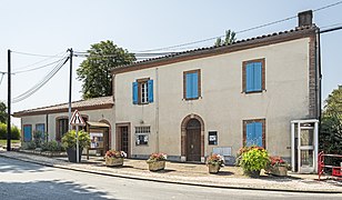 City hall
 -
 Chapel st.Marint
 -
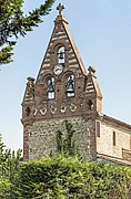 Bell gable


See also[edit]
References[edit]
- ^ "Répertoire national des élus: les maires". data.gouv.fr, Plateforme ouverte des données publiques françaises (in French). 2 December 2020.
- ^ "Populations légales 2021". The National Institute of Statistics and Economic Studies. 28 December 2023.
Wikimedia Commons has media related to Teulat.
| Authority control databases: National |
|---|
This Tarn geographical article is a stub. You can help Wikipedia by expanding it. |