
Aisey-sur-Seine
Aisey-sur-Seine | |
|---|---|
 The Bridge of Troubles on the Seine at Aisey-sur-Seine | |
 Coat of arms | |
Location of Aisey-sur-Seine  | |
 Aisey-sur-Seine  Aisey-sur-Seine | |
| Coordinates: 47°45′04″N 4°34′52″E / 47.7511°N 4.5811°E | |
| Country | France |
| Region | Bourgogne-Franche-Comté |
| Department | Côte-d'Or |
| Arrondissement | Montbard |
| Canton | Châtillon-sur-Seine |
| Intercommunality | Pays Châtillonnais |
| Government | |
| • Mayor (2020–2026) | Gérard Eme[1] |
| Area 1 | 12.72 km2 (4.91 sq mi) |
| Population (2021)[2] | 171 |
| • Density | 13/km2 (35/sq mi) |
| Time zone | UTC+01:00 (CET) |
| • Summer (DST) | UTC+02:00 (CEST) |
| INSEE/Postal code | 21006 /21400 |
| Elevation | 251–379 m (823–1,243 ft) (avg. 264 m or 866 ft) |
| 1 French Land Register data, which excludes lakes, ponds, glaciers > 1 km2 (0.386 sq mi or 247 acres) and river estuaries. | |
Aisey-sur-Seine (French pronunciation: [ɛzɛ syʁ sɛn], literally Aisey on Seine) is a commune in the Côte-d'Or department in the Bourgogne-Franche-Comté region of eastern France.
Geography[edit]
Aisey-sur-Seine is located some 12 km south of Chatillon-sur-Seine and about 25 km north-east of Montbard. The commune can be reached by travelling east from Coulmier-le-Sec on Highway D29 which passes through the heart of the commune and the town before continuing east to join Highway D16 near Saint-Germain-le-Rocheux. The commune can also be accessed from the north on Highway D971 (the Route de Dijon) from Nod-sur-Seine. Highway D971 continues through the town and commune south to Saint-Marc-sur-Seine. Other highways entering the commune are the D101A from Chemin-d'Aisey in the south-west and the D29C cross-country road from Nod-sur-Seine which joins Highway D29 in the commune. The commune has large areas of forest - especially in the east and the south with some farmland on the western side.[3]
The commune is traversed by the Seine river which forms part of the south-eastern boundary before passing northwards through the town then along a part of the northern border before continuing north to Chamesson. The Brevon Stream which forms the south-eastern boundary of the commune joins the Seine near the intersection of Highway D29 and D101 (a side road from the D971).[3]
Neighbouring Communes and Villages[edit]
Places adjacent to Aisey-sur-Seine | |
|---|---|
History[edit]
Formerly known as Aisey-le-Duc.
In the Middle Ages, Aisey-sur-Seine was the seat of a lordship. There is a well-preserved Fortified house with a game park.[4]

Heraldry[edit]
|
The official status of the blazon remains to be determined.
The arms of the commune of Abos are blazoned : Quarterly, first of Gules a saltire couped debruised by a pallet couped, all of Or; the second Azure of three fleurs-de-lis of Or 2 and 1 and a bendlet couped of Gules; the third Azure with lion of Or; the fourth Or with a tree Vert eradicated in chief Gules charged with a mullet of Or between two roundels the same.
|
Administration[edit]


List of Successive Mayors of Aisey-sur-Seine[5]
| From | To | Name | Party | |
|---|---|---|---|---|
| 1995 | 2001 | Pierre Mars | ||
| 2001 | 2008 | Jean Abord-Hugon | ind. | |
| 2008 | 2026 | Gérard Ème |
Population[edit]
The inhabitants of the commune are known as Aiseyens or Aiseyennes in French.[6]
| Year | Pop. | ±% p.a. |
|---|---|---|
| 1968 | 219 | — |
| 1975 | 150 | −5.26% |
| 1982 | 147 | −0.29% |
| 1990 | 172 | +1.98% |
| 1999 | 196 | +1.46% |
| 2007 | 218 | +1.34% |
| 2012 | 199 | −1.81% |
| 2017 | 176 | −2.43% |
| Source: INSEE[7] | ||


Culture and heritage[edit]
Civil heritage[edit]
The commune has many buildings and structures that are registered as historical monuments:
- A Lavoir (Public laundry) and the Fountain of April (1846)
 [8]
[8] - The Maison Huguenin Hospice and Charity House (1846)[9]
- A House (1) at Grande Rue (19th century)[10]
- A House (2) at Grande Rue (19th century)[11]
- A House at Rue Haute (19th century)[12]
- A Flour Mill at Rue du Pont (19th century)[13]
- A Lavoir (Public laundry) at Rue du Pont (18th century)[14]
- A Bridge at Rue du Pont (17th century)[15]
- The Chateau de Tavannes at RN 71 (15th century)[16][17]
- The Bridge of Troubles at RN 71 (17th century)[18]
- A House at Rue Rougeot (19th century)[19]
- A Lavoir (Public laundry) and Drinking Trough at Grande Rue (19th century)[20]
- The Town Hall / School at Grande Rue (19th century)[21]
- Houses (19th century)[22]
- The Chateau of the Dukes of Burgundy at La Barque (12th century)[23]
Religious heritage[edit]
The commune has several religious buildings and structures that are registered as historical monuments:
- A Cemetery Cross at Chemin des Chenevières (19th century)[24]
- A Cemetery at Chemin des Chenevières (19th century)[25]
- A Wayside Cross at CVO 3 and CR 7 crossroads (1826)[26]
- A Wayside Cross at Rue de la Poterne and CR 18 crossroads (1866)[27]
- A Wayside Cross at RD 29 and RD 101a crossroads (1830)[28]
- A Wayside Cross at Grande Rue (1767)[29]
- A Presbytery at Grande Rue (18th century)[30]
- The Parish Church of Saint-Genest at Grande Rue (19th century).[31] The church contains a very large number of items that are registered as historical objects.[31]
Gallery of Historical Monuments[edit]
-
 The Maison Huguenin Hospice and Charity House
 -
 The Flour Mill at Rue du Pont
 -
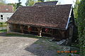 The Lavoir (Public laundry) at Rue du Pont
 -
 The Bridge at Rue du Pont
 -
 The Chateau de Tavannes
 -
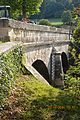 The Bridge of Troubles
 -
 The Cemetery Cross at Chemin des Chenevières
 -
 The Cemetery at Chemin des Chenevières
 -
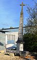 The Wayside Cross at Rue de la Poterne and CR 18 crossroads
 -
 The Wayside Cross at Grande Rue
 -
 The Church of Saint-Genest


See also[edit]
References[edit]
- ^ "Répertoire national des élus: les maires" (in French). data.gouv.fr, Plateforme ouverte des données publiques françaises. 13 September 2022.
- ^ "Populations légales 2021". The National Institute of Statistics and Economic Studies. 28 December 2023.
- ^ a b c Google Maps
- ^ Élisabeth Sirot, Noble and Fortified houses - the lordly habitats in the Middle Ages from the mid-12th to the beginning of the 16th centuries, Editions Picard, 2007, ISBN 978-2-7084-0770-1, passage 71.
- ^ List of Mayors of France (in French)
- ^ Le nom des habitants du 21 - Côte-d'Or, habitants.fr
- ^ Population en historique depuis 1968, INSEE
- ^ Ministry of Culture, Mérimée IA00096232 Lavoir and Fountain of April (in French)
- ^ Ministry of Culture, Mérimée IA00096241 Maison Huguenin Hospice and Charity House (in French)

- ^ Ministry of Culture, Mérimée IA00096240 House (1) at Grande Rue (in French)
- ^ Ministry of Culture, Mérimée IA00096314 House (2) at Grande Rue (in French)
- ^ Ministry of Culture, Mérimée IA00096313 House at Rue Haute (in French)
- ^ Ministry of Culture, Mérimée IA00096311 Flour Mill at Rue du Pont (in French)
- ^ Ministry of Culture, Mérimée IA00096233 Lavoir at Rue du Pont (in French)
- ^ Ministry of Culture, Mérimée IA00096229 Bridge at Rue du Pont (in French)
- ^ Ministry of Culture, Mérimée IA00096366 Chateau de Tavannes (in French)
- ^ Ministry of Culture, Mérimée PA00112052 Chateau de Tavannes (in French)
- ^ Ministry of Culture, Mérimée IA00096228 Bridge of Troubles at RN 71 (in French)
- ^ Ministry of Culture, Mérimée IA00096315 House at Rue Rougeot (in French)
- ^ Ministry of Culture, Mérimée IA00096231 Lavoir and Drinking Trough at Grande Rue (in French)
- ^ Ministry of Culture, Mérimée IA00096227 Town Hall / School at Grande Rue (in French)
- ^ Ministry of Culture, Mérimée IA00096312 Houses (in French)
- ^ Ministry of Culture, Mérimée IA00096226 Chateau of the Dukes of Burgundy at La Barque (in French)
- ^ Ministry of Culture, Mérimée IA00096239 Cemetery Cross at Chemin des Chenevières (in French)
- ^ Ministry of Culture, Mérimée IA00096234 Cemetery at Chemin des Chenevières (in French)
- ^ Ministry of Culture, Mérimée IA00096235 Wayside Cross at CVO 3 and CR 7 crossroads (in French)
- ^ Ministry of Culture, Mérimée IA00096236 Wayside Cross at Rue de la Poterne and CR 18 crossroads (in French)
- ^ Ministry of Culture, Mérimée IA00096238 Wayside Cross at RD 29 and RD 101a crossroads (in French)
- ^ Ministry of Culture, Mérimée IA00096237 Wayside Cross at Grande Rue (in French)
- ^ Ministry of Culture, Mérimée IA00096230 Presbytery at Grande Rue (in French)
- ^ a b Ministry of Culture, Mérimée IA00096225 Parish Church of Saint-Genest at Grande Rue (in French)
External links[edit]
- Aisey-sur-Seine on Géoportail, National Geographic Institute (IGN) website (in French)
- Aifey le Duc on the 1750 Cassini Map
| International | |
|---|---|
| National | |