Aignay-le-Duc
Aignay-le-Duc | |
|---|---|
 The bell tower of the church in Aignay-le-Duc | |
| Coordinates: 47°39′59″N 4°44′08″E / 47.6664°N 4.7356°E | |
| Country | France |
| Region | Bourgogne-Franche-Comté |
| Department | Côte-d'Or |
| Arrondissement | Montbard |
| Canton | Châtillon-sur-Seine |
| Intercommunality | Pays Châtillonnais |
| Government | |
| • Mayor (2023–2026) | Gilbert Changarnier[1] |
| Area 1 | 24.86 km2 (9.60 sq mi) |
| Population (2021)[2] | 265 |
| • Density | 11/km2 (28/sq mi) |
| Time zone | UTC+01:00 (CET) |
| • Summer (DST) | UTC+02:00 (CEST) |
| INSEE/Postal code | 21004 /21510 |
| Elevation | 310–443 m (1,017–1,453 ft) (avg. 330 m or 1,080 ft) |
| 1 French Land Register data, which excludes lakes, ponds, glaciers > 1 km2 (0.386 sq mi or 247 acres) and river estuaries. | |
Aignay-le-Duc (French pronunciation: [ɛɲɛ lə dyk]) is a commune in the Côte-d'Or department in the Bourgogne-Franche-Comté region of eastern France.
Geography[edit]
The commune of Aignay-le-Duc is located some 30 km south-east of Châtillon-sur-Seine and some 30 km east of Montbard in a direct line. Access to the commune is by Highway D901 which enters on the north-west border, continues to the village and exits the south-east border. There is also Highway D101 linking the village to Étalante to the south-east. Highway D954 links the village through the eastern border to Saint-Broing-les-Moines. There is also Highway D112 which exits the commune in the north-east. There are extensive forests in the eastern part of the commune (Bois de Fort Fais, Bois du Bas des Soulers etc.) with about two thirds of the commune farmland. There are no villages other than Aignay-le-Duc.
The Coquille stream flows through the town and forming the eastern border is the Brevon stream. The Coquille flows to the Revinson stream which joins the Seine river. The Brevon flows north and eventually joins the Seine near Brémur-et-Vaurois.
Neighbouring Communes and Villages[edit]
History[edit]
Aignay-le-Duc belonged to the territory of Lingons and had a Celtic population. Its name may come from the Celtic: Ann-iacum meaning "The location of the water source" ann- is a well known root name for rivers [e.g. l'Ain, Inn (Austria), Anio (Italy)]. The village is close to the source of the Coquille.[3]
A yellow limestone used in the cemetery, dating from the late second century or early third century AD, is inscribed: Aug (ustis) sac (rum) deo Marti Cicolluis et Litavi P. Attius Paterc[l]u[s] [v(otum) s(olvit) l(ibens) m(erito)] which means: "To the august sacred deities, to the god Mars Cicolluis and Litavi, P. Attius Paterculus paid his vow willingly and deservedly".[4][5]
An inscription was found on a bronze vase near Aignay in 1896 which, according to Chassenay, said: Aug(usto) sacr(um) deo Albio et Damonae Sext(us) Mart(ius) Cociliani f(ilius) ex jussu ejus [v(otum)] s(olvit) l(ibens) m(erito) meaning "It is sacred to Augustus, to the gods Albius and Damona, Sextus Martius, son of Cocilianus, in order to fulfill his vow.[6]
During the revolutionary period of the National Convention (1792-1795), the town took the name of Aignay-Côte-d'Or abbreviated to Aignay.[7]

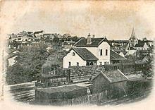
Here is seen the station.
Heraldry[edit]
 |
Blazon: Gules, six billets argent set 3, 2, 1.
|
Administration[edit]
List of Successive Mayors of Aignay-le-Duc[8]
| From | To | Name | Party |
|---|---|---|---|
| 1989 | 2008 | Bernard Bonnuit | DVD |
| 2008 | 2009 | Alexandre Misset | SE |
| 2014 | 2023 | Frédéric Bourdenet | |
| 2023 | 2026 | Gilbert Changarnier[1] |
Population[edit]
The inhabitants of the commune are known as Aignacois or Aignacoises in French.[9]
|
| ||||||||||||||||||||||||||||||||||||||||||||||||||||||||||||||||||||||||||||||||||||||||||||||||||||||||||||||||||
| Source: EHESS[7] and INSEE[10] | |||||||||||||||||||||||||||||||||||||||||||||||||||||||||||||||||||||||||||||||||||||||||||||||||||||||||||||||||||
Culture and heritage[edit]
Civil heritage[edit]
The commune has a large number of Houses that are registered as historical monuments.[11]
The commune also has many other buildings and structures that are registered as historical monuments:
- A Lavoir (Public laundry) at Rue de la Demoiselle (19th century)
 [12]
[12] - A Fountain at Rue de la Planchotte (18th century)
 [13]
[13] - A Barn at Rue de l'Ile (1790)
 [14]
[14] - A Bridge at Rue de l'Ile (19th century)
 [15]
[15] - The Lavoir de la Margelle (Public laundry) at Rue de la Margelle (18th century)
 [16]
[16] - A Railway worker refuge at RN 454 (19th century)
 [17]
[17] - A Lavoir (Public laundry) at Rue des Vieilles Halles (19th century)
 [18]
[18] - A Farmhouse at Grand Bois (17th century)
 [19]
[19] - The Pierre-Fiche Menhir (Prehistoric)
 [20]
[20] - A Commemorative Monument at Combe des Carrés (1839)
 [21]
[21] - The Covered Market (18th century)
 [22]
[22] - The Town Hall / School (1789)
 [23]
[23] - The Urban Area Fortification (15th century)
 [24]
[24]
- Other sites of interest
- Celtic Tumuli have been found including several burials from different periods, the most recent dating to the 5th century AD.
Religious heritage[edit]

The commune has several religious buildings and structures that are registered as historical monuments:
- A Wayside Cross at Chemin de Beaunotte (1831)
 [25]
[25] - A Wayside Cross at Chevigny Farm (17th century)
 [26]
[26] - A Wayside Cross at Rue des Granges (1674)
 [27]
[27] - The Croix Lannier Wayside Cross north of the village (1662)
 [28]
[28] - The Croix Mignard Wayside Cross north-east of the village (17th century)
 [29]
[29] - A Presbytery (19th century).
 [30] The Presbytery contains several items that are registered as historical objects:
- A Wayside Cross at Grand Bois (16th century)
 [36]
[36] - A Monumental Cross at Saint-Michel (1637)
 [37]
[37] - A Tomb (19th century)
 [38]
[38] - A Cemetery Cross (1637)
 [39]
[39] - The Cemetery Portal (19th century)
 [40]
[40] - The Church of Saint Peter and Saint Paul (1170).
 [41][42] The Church contains a very large number of items which are registered as historical objects.[42]
-
The Renaissance altarpiece
-
Detail of the altarpiece
Notable People linked to the Commune[edit]
- Nicolas Frochot, an influential provost of Aignay-le-Duc, he ended his career as a State Councilor and first Prefect of the Seine under Napoleon I.
- Claude-Auguste Petit, Baron of Beauverger (born Aignay-le-Duc, 7 October 1748 - died Paris, 6 September 1819), brother of the Nicholas Frochot, French politician.
- Bertrand Lavier, French contemporary multimedia artist born in Châtillon-sur-Seine (Côte-d'Or) 14 June 1949. He lives and works in Paris and Aignay-le-Duc (Côte-d'Or).
- The Baudus Family
- Philippe Bertrand, a host on France Inter
See also[edit]
References[edit]
- ^ a b "Répertoire national des élus: les maires" (in French). data.gouv.fr, Plateforme ouverte des données publiques françaises. 30 November 2023.
- ^ "Populations légales 2021". The National Institute of Statistics and Economic Studies. 28 December 2023.
- ^ Taverdet G. Names in the region of Bourgognes, 2007, p. 112.
- ^ BECK N. thesis. Goddesses in Celtic Religion Cult and Mythology: A Comparative Study of Ancient Ireland, Britain and Gaul, 2009, 110.
- ^ cited in the thesis: Drioux, 1934, p. 74, n° 267; Le Bohec, 2003, p. 176, n°295. (in French)
- ^ CIL XIII, 2887, CIL XIII, 11233
- ^ a b Des villages de Cassini aux communes d'aujourd'hui: Commune data sheet Aignay-le-Duc, EHESS (in French).
- ^ List of Mayors of France (in French)
- ^ Le nom des habitants du 21 - Côte-d'Or, habitants.fr
- ^ Population en historique depuis 1968, INSEE
- ^ Base Mérimée: Search for heritage in the commune, Ministère français de la Culture. (in French)
- ^ Ministry of Culture, Mérimée IA00054270 Lavoir at Rue de la Demoiselle (in French)
- ^ Ministry of Culture, Mérimée IA00054273 Fountain at Rue de la Planchotte (in French)
- ^ Ministry of Culture, Mérimée IA00054310 Barn at Rue de l'Ile (in French)
- ^ Ministry of Culture, Mérimée IA00054274 Bridge at Rue de l'Ile (in French)
- ^ Ministry of Culture, Mérimée IA00054271 Lavoir de la Margelle at Rue de la Margelle (in French)

- ^ Ministry of Culture, Mérimée IA00054279 Railway worker refuge at RN 454 (in French)
- ^ Ministry of Culture, Mérimée IA00054272 Lavoir at Rue des Vieilles Halles (in French)
- ^ Ministry of Culture, Mérimée IA00054309 Farmhouse at Grand Bois (in French)
- ^ Ministry of Culture, Mérimée IA00054280 Pierre-Fiche Menhir (in French)
- ^ Ministry of Culture, Mérimée IA00054278 Commemorative Monument at Combe des Carrés (in French)
- ^ Ministry of Culture, Mérimée IA00054269 Covered Market (in French)
- ^ Ministry of Culture, Mérimée IA00054268 Town Hall / School (in French)
- ^ Ministry of Culture, Mérimée IA00054266 Urban Area Fortification (in French)
- ^ Ministry of Culture, Mérimée IA00054282 Wayside Cross at Chemin de Beaunotte (in French)
- ^ Ministry of Culture, Mérimée IA00054283 Wayside Cross at Chevigny Farm (in French)
- ^ Ministry of Culture, Mérimée IA00054286 Wayside Cross at Rue des Granges (in French)
- ^ Ministry of Culture, Mérimée IA00054285 Croix Lannier Wayside Cross north of the village (in French)
- ^ Ministry of Culture, Mérimée IA00054284 Croix Mignard Wayside Cross north-east of the village (in French)
- ^ Ministry of Culture, Mérimée IA00054288 Presbytery (in French)
- ^ Ministry of Culture, Palissy IM21005169 Furniture in the Presbytery (in French)
- ^ Ministry of Culture, Palissy IM21005168 Processional Staff (in French)
- ^ Ministry of Culture, Palissy IM21005167 Statue: Virgin and child (2) (in French)
- ^ Ministry of Culture, Palissy IM21005166 Statue: Virgin and child (1) (in French)
- ^ Ministry of Culture, Palissy IM21005165 Statue: Saint Eloi (in French)
- ^ Ministry of Culture, Mérimée IA00054287 Wayside Cross at Grand Bois (in French)
- ^ Ministry of Culture, Mérimée IA00054281 Monumental Cross at Saint-Michel (in French)
- ^ Ministry of Culture, Mérimée IA00054277 Tomb (in French)
- ^ Ministry of Culture, Mérimée IA00054276 Cemetery Cross (in French)
- ^ Ministry of Culture, Mérimée IA00054275 Cemetery Portal (in French)
- ^ Ministry of Culture, Mérimée PA00112051 Church of Saint Peter and Saint Paul (in French)

- ^ a b Base Mérimée: IA00054267 Church of Saint Peter and Saint Paul, Ministère français de la Culture. (in French)
External links[edit]
- Aignay-le-Duc on the website of the National Geographic Institute (in French)
- Aignay-le-Duc on Géoportail, National Geographic Institute (IGN) website (in French)
- Aignay-le-Duc on the 1750 Cassini Map


