
Portal:Andes
The Andes Portal

The Andes (/ˈændiːz/ AN-deez), Andes Mountains or Andean Mountain Range (Spanish: Cordillera de los Andes; Quechua: Anti) are the longest continental mountain range in the world, forming a continuous highland along the western edge of South America. The range is 8,900 km (5,530 mi) long and 200 to 700 km (124 to 435 mi) wide (widest between 18°S and 20°S latitude) and has an average height of about 4,000 m (13,123 ft). The Andes extend from South to North through seven South American countries.: Argentina, Chile, Bolivia, Peru, Ecuador, Colombia and western Venezuela.
Along their length, the Andes are split into several ranges, separated by intermediate depressions. The Andes are the location of several high plateaus—some of which host major cities such as Quito, Bogotá, Cali, Arequipa, Medellín, Bucaramanga, Sucre, Mérida, El Alto and La Paz. The Altiplano Plateau is the world's second-highest after the Tibetan Plateau. These ranges are in turn grouped into three major divisions based on climate: the Tropical Andes, the Dry Andes, and the Wet Andes.
The Andes Mountains are the highest mountain range outside Asia. The highest mountain outside Asia, Argentina's Aconcagua, rises to an elevation of about 6,961 m (22,838 ft) above sea level. The peak of Chimborazo in the Ecuadorian Andes is farther from the Earth's center than any other location on the Earth's surface, due to the equatorial bulge resulting from the Earth's rotation. The world's highest volcanoes are in the Andes, including Ojos del Salado on the Chile-Argentina border, which rises to 6,893 m (22,615 ft). (Full article...)
Selected articles
-
 Pico El Toro is a mountain in the Andes of Venezuela. It has a height of 4755 metres. (Full article...)
 -
Mount Tarn is a small mountain located on the southernmost part of the Strait of Magellan, in Brunswick Peninsula, about 70 km south of Punta Arenas, Chile. It is in the southern extreme of continental Chile very close to Cape Froward, surrounded by historic places such as Fort Bulnes and Puerto del Hambre (Port Famine).
From the summit it is possible to see the Strait of Magellan, Dawson and Tierra del Fuego islands, and many other smaller ones; the Darwin Mountain Range, Mount Sarmiento, and most of the Brunswick Peninsula. (Full article...) -
The Sierra Nevada National Park (SNNP) is a National Park of Venezuela located between the states of Mérida and Barinas in western Venezuela. It was created on May 2, 1952, by decree of President Germán Suárez Flamerich, in order to protect the Sierra Nevada de Mérida in the Andes.
It was the second national park decreed, after Henri Pittier National Park, which became the first Venezuelan national park 15 years earlier. (Full article...) -
Doña Juana (Spanish: Volcán Doña Juana) is a stratovolcano, located within the Doña Juana-Cascabel Volcanic Complex National Natural Park (Spanish: Parque Nacional Natural Complejo Volcánico Doña Juana-Cascabel) in Nariño, Colombia.
With a previous eruption of VEI 4, Doña Juana is rated as a "large" volcano of "cataclysmic" destructive power. During its last eruption, in 1906, more than 100 people were killed and many houses were destroyed. (Full article...) -
Mount Hudson (Spanish: Volcán Hudson, Spanish: Cerro Hudson, Monte Hudson) is a volcano in the rugged mountains of southern Chile. Lying in the Southern Volcanic Zone of the Andes, it was formed by the subduction of the oceanic Nazca Plate under the continental South American Plate. The Nazca Plate ends there at the Chile Triple Junction; south of Hudson is a smaller volcano, followed by a long gap without active volcanoes that separates the Southern Volcanic Zone from the Austral Volcanic Zone. Hudson has the form of a 10-kilometre-wide (6-mile) volcanic caldera filled with ice. The Huemules Glacier emerges from the northwestern side of the caldera. The volcano has erupted rocks ranging from basalt to rhyolite, but large parts of the caldera are formed by non-volcanic rocks.
The volcano erupted numerous times in the late Pleistocene and Holocene, forming widespread tephra deposits both in the proximity of Hudson and in the wider region, and is the most active volcano in the region. The last eruption was in 2011. (Full article...) -
The Illinizas are a pair of volcanic mountains that are located in the north of Latacunga, Cotopaxi, Ecuador. They are located in the Illinizas Ecological Reserve (Spanish: Reserva Ecológica Los Illinizas). These twin mountains are separated by a saddle that is about a kilometer long. The peaks are among the highest in Ecuador, with Illiniza Sur standing slightly taller than Illiniza Norte, its northern counterpart, at 5245 metres and 5126 metres respectively.
Most guidebooks (for example, Lonely Planet Ecuador, Ecuador: A Climbing Guide) spell the mountain with only one "l" as in Iliniza. The name Illinizas is derived from the Kunza words for "masculine hill." (Full article...) -
The vicuña (Lama vicugna) or vicuna (both /vɪˈkuːnjə/, very rarely spelled vicugna, its former genus name) is one of the two wild South American camelids, which live in the high alpine areas of the Andes, the other being the guanaco, which lives at lower elevations. Vicuñas are relatives of the llama, and are now believed to be the wild ancestor of domesticated alpacas, which are raised for their coats. Vicuñas produce small amounts of extremely fine wool, which is very expensive because the animal can only be shorn every three years and has to be caught from the wild. When knitted together, the product of the vicuña's wool is very soft and warm. The Inca valued vicuñas highly for their wool, and it was against the law for anyone but royalty to wear vicuña garments; today, the vicuña is the national animal of Peru and appears on the Peruvian coat of arms.
Both under the rule of the Inca and today, vicuñas have been protected by law, but they were heavily hunted in the intervening period. At the time they were declared endangered in 1974, only about 6,000 animals were left. Today, the vicuña population has recovered to about 350,000, and although conservation organizations have reduced its level of threat classification, they still call for active conservation programs to protect populations from poaching, habitat loss, and other threats. (Full article...) -
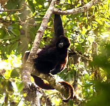
The yellow-tailed woolly monkey (Lagothrix flavicauda) is a New World monkey endemic to Peru. It is a rare primate species found only in the Peruvian Andes, in the departments of Amazonas and San Martin, as well as bordering areas of La Libertad, Huánuco, and Loreto. (Full article...) -
Pico Bonpland is Venezuela's third highest peak, at 4,883 metres above sea level. It is located in the Sierra Nevada de Merida, in the Venezuelan Andes of (Mérida State). The peak with its sister peak Pico Humboldt, and the surrounding páramos are protected by the Sierra Nevada National Park. The name of the peak is in honor of Aimé Bonpland, although he never visited the Venezuelan Andes.
The glaciers located in the Bonpland were the result from Merida glaciation in the Pleistocene. By 2011 they had all disappeared. (Full article...) -
Touching the Void is a 2003 survival documentary film directed by Kevin Macdonald and starring Brendan Mackey, Nicholas Aaron, and Ollie Ryall. The plot concerns Joe Simpson and Simon Yates' near-fatal descent after making the first successful ascent of the West Face of Siula Grande in the Cordillera Huayhuash in the Peruvian Andes, in 1985. It is based on Simpson's 1988 book of the same name.
Critically acclaimed, Touching the Void was listed in PBS's "100 Greatest Documentaries of All Time". The Guardian described it as "the most successful documentary in British cinema history". (Full article...) -
Orestias is a genus of pupfish. Older systematics classified them into the own family Orestiidae. They are found in lakes, rivers and springs in the Andean highlands of South America, and several species are considered threatened. They are egg-laying fish that feed on small animals and plant matter. The largest species can reach a total length of 27 cm (10.6 in), but most remain far smaller. Their most characteristic feature is the absence of the ventral fin, although this is shared by a few other pupfish. Despite their moderate to small size, they are important to local fisheries and a few species are farmed.
Several species are locally and colloquially known as carache. The name of the genus is a reference to Orestes, a Greek mythological character who Valenciennes described as the "nymph of the mountains". (Full article...) -
Telmatobius culeus, commonly known as the Titicaca water frog or Lake Titicaca frog, is a medium-large to very large and endangered species of frog in the family Telmatobiidae. It is entirely aquatic and found only in the Lake Titicaca basin, including rivers that flow into it and smaller connected lakes like Arapa, Lagunillas and Saracocha, in the Andean highlands of Bolivia and Peru. In reference to its excessive amounts of skin, it has jokingly been referred to as the Titicaca scrotum (water) frog.
It is closely related to the more widespread and semiaquatic marbled water frog (T. marmoratus), which also occurs in shallow, coastal parts of Lake Titicaca, but lacks the excessive skin and it is generally smaller (although overlapping in size with some forms of the Titicaca water frog). (Full article...) -
Huayna Potosí is a mountain in Bolivia, located near El Alto and about 25 km north of La Paz in the Cordillera Real.
Huayna Potosí is the closest high mountain to La Paz. Surrounded by high mountains, it is roughly 15 miles due north of the city, which makes this mountain the most popular climb in Bolivia. The normal ascent route is a fairly straightforward glacier climb, with some crevasses and a steep climb to the summit. However, the other side of the mountain—Huayna Potosí West Face—is the biggest face in Bolivia. Several difficult snow and ice routes ascend this 1,000-meter-high face. (Full article...) -
Pico El León is a mountain in the Andes of Venezuela. It has a height of 4740 metres. (Full article...) -
Illampu is the fourth highest mountain in Bolivia. It is located in the northern section of the Cordillera Real, part of the Andes, east of Lake Titicaca. It lies just north of the slightly higher Janq'u Uma, near the town of Sorata. Laguna Glaciar, located in the Illampu-Janq'u Uma massif, is the 17th highest lake in the world.
Despite being lower than Janq'u Uma, Illampu has a steeper peak, with more local relief, and is a somewhat harder climb. In fact it has "the hardest normal route on any of the 6,000 metre peaks in Bolivia." The easiest route, by the Southwest Ridge, is rated AD (Fairly Difficult), with snow slopes up to 65 degrees. It is accessed from a high camp on the north side of the massif. The peak was first climbed on June 7, 1928 via this route, by Hans Pfann, Alfred Horeschowsky, Hugo Hörtnagel (Germans) and Erwin Hein (Austrian). Other routes include the "German Route" on the southwest face and the South Face route, both approached from the west side of the massif. (Full article...) -

Map showing Iru Phutunqu on the border of Bolivia and Chile, south of the Umani
Iruputuncu (possibly from Aymara iru spiny Peruvian feather grass, phutunqu a small vessel or a hole, pit, crater) is a mountain in the Andes in the Cordillera Occidental on the border of Bolivia and Chile. The Chilean side is in the Tarapacá Region, and the Bolivian side is in the Potosí Department, Daniel Campos Province, Llica Municipality. Iruputuncu is southeast of Mount Candelaria, west of the Salar de Uyuni salt flat and south of the Umani. It is about 4,200 m (13,780 ft) high. (Full article...) -
Sierra Nevada, also known as Sierra Nevada de Lagunas Bravas, is a major ignimbrite-lava dome complex which lies in both Chile and Argentina in one of the most remote parts of the Central Andes.
Activity in the complex started in Argentina and formed two stratovolcanoes. Later, 12 or more vents formed, some with craters up to 400 metres (1,300 ft) wide. Lava flows up to 7 kilometres (4.3 mi) long with flow ridges are also found. It covers a total area of 225 km2. Radiometric dating has yielded ages of 1.7 ± 0.4 to 0.431 ± 0.012 million years ago, a lava flow from the neighbouring Azufrera Los Cuyanos volcano that is sometimes considered part of Sierra Nevada is 140,000 years old. Together with Cerro el Condor and Peinado it forms the Culampaja line, a line of volcanoes that reaches Cerro Blanco. Strong seismic attenuation is observed beneath Sierra Nevada. Hydrothermally altered rocks in Sierra Nevada may be the source of sulfate and arsenic in the Juncalito and Negro rivers, and heat sources for regional hot springs. The snowline in the area lies at 5,800 metres (19,000 ft) altitude at Cumbre del Laudo. (Full article...) -
The Nevado del Tolima is a Late Pleistocene to recently active andesitic stratovolcano located in the Tolima department, Colombia. The volcano lies south of Nevado del Ruiz volcano and is situated within the Los Nevados National Natural Park. The volcano, whose most recent activity dates to 1943 and last major eruption around 3600 years ago, overlies the Eocene El Bosque Batholith, dated at 49.1 ± 1.7 Ma. (Full article...) -
Chumpe (possibly from Quechua chumpi: belt), Jatunriti, Ñanaloma or Yanaloma is a mountain in the Vilcanota mountain range in the Andes of Peru with 6,106 metres (20,033 ft) of elevation. It is located in the Cusco Region, Canchis Province, Pitumarca District as well as in the Quispicanchi Province, Ocongate District. Chumpe lies north of Lake Sibinacocha. (Full article...) -
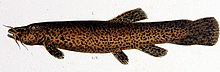
Trichomycterus rivulatus is a species of pencil catfish that is native to high-altitude Andean streams and lakes (including Junin, Poopó and Titicaca) in southern Peru, western Bolivia and northern Chile. It is the largest species in the genus Trichomycterus and grows to a maximum length of 37.4 centimetres (14.7 in) TL. The species is regularly caught as a food fish. However, because of pollution, studies have revealed levels of metals in T. rivulatus of Lake Titicaca that exceed the internationally recommended safety thresholds for human consumption. (Full article...) -
Huandoy (probably from Quechua wantuy, to transfer, to transpose, to carry, to carry a heavy load) or Tullparaju (possibly from Quechua tullpa rustic cooking-fire, stove, rahu snow, ice, mountain with snow) is a mountain located inside Huascarán National Park in Ancash, Peru. It is the second-tallest peak of the Cordillera Blanca section of the Andes, after Huascarán. These two peaks are rather nearby, separated only by the Llanganuco glacial valley (which contains the Llanganuco Lakes) at 3,846 m asl.
It is a snow-capped mountain with four peaks arranged in the form of a fireplace, the tallest of which is 6,395 m. The four peaks are each over 6,000 m, and are:- Huandoy (6,395 m)
- Huandoy-West (6,356 m)
- Huandoy-South (6,160 m)
- Huandoy-East (6,000 m)
-
Acotango is the central and highest of a group of stratovolcanoes straddling the border of Bolivia and Chile. It is 6,052 metres (19,856 ft) high. The group is known as Kimsa Chata and consists of three mountains: Acotango, Umurata (5,730 metres (18,799 ft)) north of it and Capurata (5,990 metres (19,652 ft)) south of it.
The group lies along a north–south alignment. The Acotango volcano is heavily eroded, but a lava flow on its northern flank is morphologically young, suggesting Acotango was active in the Holocene. Later research has suggested that lava flow may be of Pleistocene age. Argon-argon dating has yielded ages of 192,000±8,000 and 241,000±27,000 years on dacites from Acotango. Glacial activity has exposed parts of the inner volcano, which is hydrothermally altered. Glacial moraines lie at an altitude of 4,200 metres (13,800 ft) but a present ice cap is only found past 6,000 metres (20,000 ft) of altitude. (Full article...) -
Rasac (possibly Quechua for toad) is a mountain in the Huayhuash mountain range in west central Peru, part of the Andes. It has a summit elevation of 6,017 metres (19,741 ft), although other sources cite a height of 6,040 metres (19,816 ft). Rasac is a long, relatively squat mountain on the western edge of the Huayhuash range, across the glacier from the tallest peak in the range, Yerupajá. Although it is a 6,000 metre mountain, Rasac's broad profile is dwarfed by Yerupajá. (Full article...) -
Huascarán (Spanish pronunciation: [waskaˈɾan]) (Quechua: Waskaran), Nevado Huascarán or Mataraju is a mountain located in Yungay Province, Department of Ancash, Peru. It is situated in the Cordillera Blanca range of the western Andes. The southern summit of Huascarán (Huascarán Sur), which reaches 6,768 metres (22,205 ft), is the highest point in Peru, the northern Andes (north of Lake Titicaca), and in all of the earth's Tropics. Huascarán is the 4th highest mountain in South America after Aconcagua, Ojos del Salado, and Monte Pissis. Huascarán is ranked 25th by topographic isolation. (Full article...) -
The Sierra de La Culata is a mountain range in the largest massif in Venezuela, the Cordillera de Mérida, which in turn is part of the northern extent of the Cordillera de los Andes (Andes Mountains). The Sierra la Culata includes some of the highest peaks in Venezuela, such as Pico Piedras Blancas, Pico Pan de Azúcar, and Collado del Cóndor.
It is located between the states of Mérida and Trujillo. Most of the lagoons are a result of the Mérida glaciation. (Full article...)


.jpg)


.jpg)


Did you know...
- ... that the 1930s Polish Andean expeditions have been credited with several first ascents and the tracing of a new route to the summit of Aconcagua, the Andes' highest peak?
Need help?
Do you have a question about Andes that you can't find the answer to?
Consider asking it at the Wikipedia reference desk.
General images
-
 Topographic map of the Andes by the NASA. The southern and northern ends of the Andes are not shown. The Bolivian Orocline is visible as a bend in the coastline and the Andes lower half of the map. (from Andean orogeny)
 -
 Simplified sketch of the present-situation along most of the Andes (from Andean orogeny)
 -

-
 Laguna de Sonso tropical dry forest in Northern Andes (from Andes)
 -
 View of Cuernos del Paine in Torres del Paine National Park, Chile (from Andes)
 -
 Bolivian Andes (from Andes)
 -
 Central Andes (from Andes)
 -
 Paleogeography of the Late Cretaceous South America. Areas subject to the Andean orogeny are shown in light grey while the stable cratons are shown as grey squares. The sedimentary formations of Los Alamitos and La Colonia that formed in the Late Cretaceous are indicated. (from Andean orogeny)
 -

-
 The seaward tilting of the sedimentary strata of Salto del Fraile Formation in Peru was caused by the Andean orogeny. (from Andean orogeny)
 -
 Peruvian farmers sowing maize and beans (from Andes)
 -
 Ulluco: Common crop of the Andean region (from Andean agriculture)
 -

-
 Map of a north-south sea-parallel pattern of rock ages in western Colombia. This pattern is a result of the Andean orogeny. (from Andean orogeny)
 -
 Pacha Mama Ceremony (from Andean agriculture)
 -

-

-
 Frederic Edwin Church, Heart of the Andes, 1859. (from Andes)
 -
 Pico Humboldt at sunset (from Andes)
 -

-

-

-
 Irrigating land in the Peruvian Andes (from Andes)
 -
 Aerial view of Valle Carbajal in the Tierra del Fuego. The Andes range is about 200 km (124 mi) wide throughout its length, except in the Bolivian flexure where it is about 640 kilometres (398 mi) wide. (from Andes)
 -
 A male Andean cock-of-the-rock, a species found in humid Andean forests and the national bird of Peru (from Andes)
 -
 Syncline next to Nordenskjöld Lake in Torres del Paine National Park. The syncline formed during the Andean orogeny. (from Andean orogeny)
 -
 Mashua tubers (from Andean agriculture)
 -

-

-
 Nevado del Huila, Colombia (from Andes)
 -
 Map of the Andean region of South America (from Andean agriculture)
 -

-
 Parinacota, Bolivia/Chile (from Andes)


.jpg)


.jpg)


.jpg)


%E2%80%93Valle_Carbajal_01.jpg)


.JPG)


.jpg)


Subcategories

- Select [►] to view subcategories
Related portals
Subtopics
Associated Wikimedia
The following Wikimedia Foundation sister projects provide more on this subject:
-
 Commons
Free media repository -
 Wikibooks
Free textbooks and manuals -
 Wikidata
Free knowledge base -
 Wikinews
Free-content news -
 Wikiquote
Collection of quotations -
 Wikisource
Free-content library -
 Wikiversity
Free learning tools -
 Wiktionary
Dictionary and thesaurus


