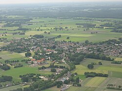
Wintelre
Wintelre
Wintersel | |
|---|---|
Village | |
 Aerial view | |
| Coordinates: 51°27′N 5°20′E / 51.450°N 5.333°E | |
| Country | |
| Province | |
| Municipality | |
| Area | |
| • Total | 17.41 km2 (6.72 sq mi) |
| Elevation | 23 m (75 ft) |
| Population (2021)[1] | |
| • Total | 2,030 |
| • Density | 120/km2 (300/sq mi) |
| Time zone | UTC+1 (CET) |
| • Summer (DST) | UTC+2 (CEST) |
| Postal code | 5513[1] |
| Dialing code | 040 |
Wintelre is a village in the municipality of Eersel in the province of North Brabant, the Netherlands. Wintelre is part of the Acht Zaligheden (Eight Beatitudes), like Eersel, Duizel, Steensel, Knegsel, Netersel, Hulsel en Reusel.
The village was first mentioned in the 13th century as Winterlo. The etymology is unclear.[3]
In 1320, a Mary chapel was built in Wintelre. In 1570, it was replaced by a church, but was turned over to the Dutch Reformed church in 1648, and started to decay due to the small size of the Protestant congregation. In 1822, a new Catholic church is built. A tower was added between 1857 and 1859. Between 1930 and 1931, a new church was built next to the old one. The old church was later demolished, but the tower remained.[4]
Wintelre was home to 435 people in 1840.[4]
Gallery[edit]
-
Wintelre, church: the Sint Willibrorduskerk
-
Clergy house
-
Sacred Heart statue with lion
References[edit]
- ^ a b c "Kerncijfers wijken en buurten 2021". Central Bureau of Statistics. Retrieved 16 April 2022.
- ^ "Postcodetool for 5513AA". Actueel Hoogtebestand Nederland (in Dutch). Het Waterschapshuis. Retrieved 16 April 2022.
- ^ "Wintelre - (geografische naam)". Etymologiebank (in Dutch). Retrieved 16 April 2022.
- ^ a b "Wintelre". Plaatsengids (in Dutch). Retrieved 16 April 2022.


