
Wikipedia:Graphics Lab/Map workshop/Archive/Aug 2021
| This page is an archive. Do not edit the contents of this page. Please direct any additional comments to the current main page. |

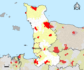
Request: Location Map of Wellington, New Zealand
-
 Auckland Region
 -
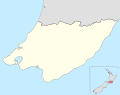 Wellington Region


- Article(s)
- 2021 New Zealand National League
- New Zealand National League
- Central League
- Request
- Hello, I am looking for a map of the Wellington Region similar to the one of the Auckland Region above. This would be used for showing the locations of the Wellington teams on these pages, as they are all so bunched together. If you are able to help please let me know. Regards -- Kezyfooty (talk) 08:05, 22 August 2021 (UTC)
- Discussion
![]() Request taken by DutchTreat (talk) 14:52, 8 September 2021 (UTC).
Request taken by DutchTreat (talk) 14:52, 8 September 2021 (UTC).
@Kezyfooty: I will help you move forward. My understadning from your request is that no existing map suits your needs. Have you tried the Module:Location map/data/New Zealand Wellington whichs covers only the city of Wellington, not the region. Please confirm that you have tried to use this existing city map before I start on a new one for the region. Take care - DutchTreat (talk) 14:52, 8 September 2021 (UTC)
- Hello @DutchTreat:, thank you very much for taking this on board. Yes I have seen that, but unfortunately it is not quite what I am looking for. I would be looking for more of the region as well as the style shown above if possible. Cheers -- Kezyfooty (talk) 04:13, 11 September 2021 (UTC)
- @Kezyfooty: Let me have a look at the details. This will be my first Locator map project, so will need some extra time to learn the process. - DutchTreat (talk) 10:57, 11 September 2021 (UTC)
- @DutchTreat: No worries mate. Thank you for helping me with this. -- Kezyfooty (talk) 02:03, 12 September 2021 (UTC)
- @Kezyfooty: Your map is ready. Available from {{Location map}} as "New Zealand Wellington Region". Let me know if you have any comments or corrections. - DutchTreat (talk) 13:50, 17 September 2021 (UTC)
- @DutchTreat: Thank you mate, that looks good. Would it be possible to have a slightly thicker line between the Wellington Region and the Manawatu-Wanganui Region? Apart from that it looks really good. Thank you so much mate - Kezyfooty (talk) 23:15, 17 September 2021 (UTC)
- @Kezyfooty: Sure! Made three changes: thicker border line, changed the extents to zoom in a bit more and added the highlight region into the outline box in the lower left. I am glad to hear that you will find this map usual. If there are no other requested changes, please mark with as {{resolved}}. If you need anymore changes, let me know. Cheers - DutchTreat (talk) 10:27, 18 September 2021 (UTC)
- @DutchTreat: Thank you so much. Looks great! {{resolved}}
- @Kezyfooty: Sure! Made three changes: thicker border line, changed the extents to zoom in a bit more and added the highlight region into the outline box in the lower left. I am glad to hear that you will find this map usual. If there are no other requested changes, please mark with as {{resolved}}. If you need anymore changes, let me know. Cheers - DutchTreat (talk) 10:27, 18 September 2021 (UTC)
- @DutchTreat: Thank you mate, that looks good. Would it be possible to have a slightly thicker line between the Wellington Region and the Manawatu-Wanganui Region? Apart from that it looks really good. Thank you so much mate - Kezyfooty (talk) 23:15, 17 September 2021 (UTC)
- @Kezyfooty: Your map is ready. Available from {{Location map}} as "New Zealand Wellington Region". Let me know if you have any comments or corrections. - DutchTreat (talk) 13:50, 17 September 2021 (UTC)
- @DutchTreat: No worries mate. Thank you for helping me with this. -- Kezyfooty (talk) 02:03, 12 September 2021 (UTC)
- @Kezyfooty: Let me have a look at the details. This will be my first Locator map project, so will need some extra time to learn the process. - DutchTreat (talk) 10:57, 11 September 2021 (UTC)
Request: Update Countries by medals 2020 Summer Olympics map

- Article(s)
- 2020 Summer Olympics medal table
- Request
- This map needs to be updated. France (7 total), Croatia (2 total), South Africa (2 total), Egypt (2 total), Denmark (1 total), Norway (1 total) and New Zealand (1 total) have all won at least one medal, yet this is not shown on the map as none of these countries are currently in green. Totals as of 27 July 2021. Helper201 (talk) 18:07, 27 July 2021 (UTC)
- Discussion
- This map has already been replaced by File:2020_Summer_Olympics_medal_map.svg which is being actively maintained. Kmusser (talk) 16:17, 31 July 2021 (UTC)
- Kmusser, the map you linked was displayed on 2020 Summer Olympics medal table at the same time as the map I am requesting an update for. As far as I'm aware that map was not meant to replace this one. Both show something different. The map you mentioned shows the highest medal achieved by each country, whereas the map I am requesting an update for shows the amount of medals won by each country. I removed the map I'm posting about from the page because of how outdated it had become but both did exist on the page at the same time before I removed it because they display different information. Helper201 (talk) 14:31, 1 August 2021 (UTC)
Request

-
 There's already one for the Spanish Sahara that could be used for the Ifni, for example
 -
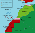 Meanwhile other pages use this
 -
 Or this


- Article(s)
- French Territory of the Afars and the Issas
- French Somaliland
- Ifni
- Spanish Guinea
- Portuguese Mozambique
- Portuguese Angola
- Portuguese Guinea
- Portuguese Cape Verde
- Portuguese India
- Request
- I think it would be more appropriate to create new colonial-era maps for the former colonial/overseas territories in Africa. The ones I speak of more specifically would be the Spanish Ifni/Guinea, Portuguese Mozambique/Angola/Guinea/Cape Verde/India, and the former French Somaliland/Afars and the Issas (I tried to do this myself but didn't manage to do it successfully). These pages' images have either current locator maps or png-format images that are not consistent with other pages' green-grey orthographic projection svg-format files. I believe it would be better to use a format that includes the colonial power as well as the overseas territory, such as the one seen in the page for the French Antartic in the case of French Somaliland, for example; or rather, a brand new file, such as in the case of the Spanish Ifni. Perhaps there's some other territories I've missed (right now the Spanish Cuba/Puerto Rico come to mind), but nonetheless I believe that for the sake of consistency these relatively modern territories should recieve their .svg files as well. Should I need to clear any doubts, I'd be happy to help. Apologies for the wall of text, but I've attempted to explain myself in the best way possible. Cheers. -- 180app (talk) 23:35, 11 August 2021 (UTC)
- Discussion
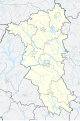
Amish in Ohio
-
 Map of Ohio highlighting Holmes County
 -
 Map of Ohio highlighting Geauga County
 -
 Blank map in new style of locator maps
 -
 Finished


- Article(s)
- User:Valereee/Amish in Ohio
- Request
- The Amish in Ohio are clustered around two counties, and I'd like to use a single map instead of two maps to illustrate this. I'd like to have them highlighted in different colors rather than in the same colors, and not red/green. Maybe red/blue? —valereee (talk) 16:04, 18 August 2021 (UTC)
- Valereee, so do you want both those maps merged, and 2 areas to be highlighted? I can do that quite quickly. Do you also want to keep this map style, or use a map with the standard conventions? — Berrely • Talk∕Contribs 17:29, 18 August 2021 (UTC)
- I've added the new style above. — Berrely • Talk∕Contribs 17:30, 18 August 2021 (UTC)
- Valereee, so do you want both those maps merged, and 2 areas to be highlighted? I can do that quite quickly. Do you also want to keep this map style, or use a map with the standard conventions? — Berrely • Talk∕Contribs 17:29, 18 August 2021 (UTC)
- Discussion
Marking as resolved given discussion above. {{resolved}}
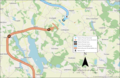
Northern line extension
-
 SVG
SVG

- Article(s)
- Northern Line Extension
- Request
- Hello, I'm rewriting this page before this project opens later this month, and there are not many pictures or diagrams. The only maps on the page right now are not geographic, more Tube map style diagrams. Are you able to create a geographical map of the route from this official map in a similar style to this excellent work by Berrely? Key features would be the black of the existing Northern line, Kennington tube station, the general route of the extension in a different colour, the location of the two proposed stations, the River Thames and (maybe yes, maybe not - depending on the scale/style of the map) the location of the US Embassy and Battersea Power Station. Thanks! Turini2 (talk) 22:44, 10 September 2021 (UTC)
- Discussion
- I might have a go later, but getting the roads in the map I made was a nightmare; we'll see... — Berrely • Talk∕Contribs 17:47, 11 September 2021 (UTC)
- @Turini2, I need to go now, and will continue tomorrow, but here is my draft. Feel free to suggest any improvements. — Berrely • Talk∕Contribs 19:57, 11 September 2021 (UTC)
- Hey Berrely, this looks great - some corrections for you. Kennington rather than Kensington, and can you add "Power Station" to the Battersea station name? If you could label the bridge "Vauxhall bridge" or the nearby area to the bridge "Vauxhall" that would also be great. Looks good though! Turini2 (talk) 20:08, 11 September 2021 (UTC)
- @Turini2, I need to go now, and will continue tomorrow, but here is my draft. Feel free to suggest any improvements. — Berrely • Talk∕Contribs 19:57, 11 September 2021 (UTC)
Closing given above {{resolved}}
Pelham Bay Monorail route

- Article(s)
- Pelham Park and City Island Railway
- Request
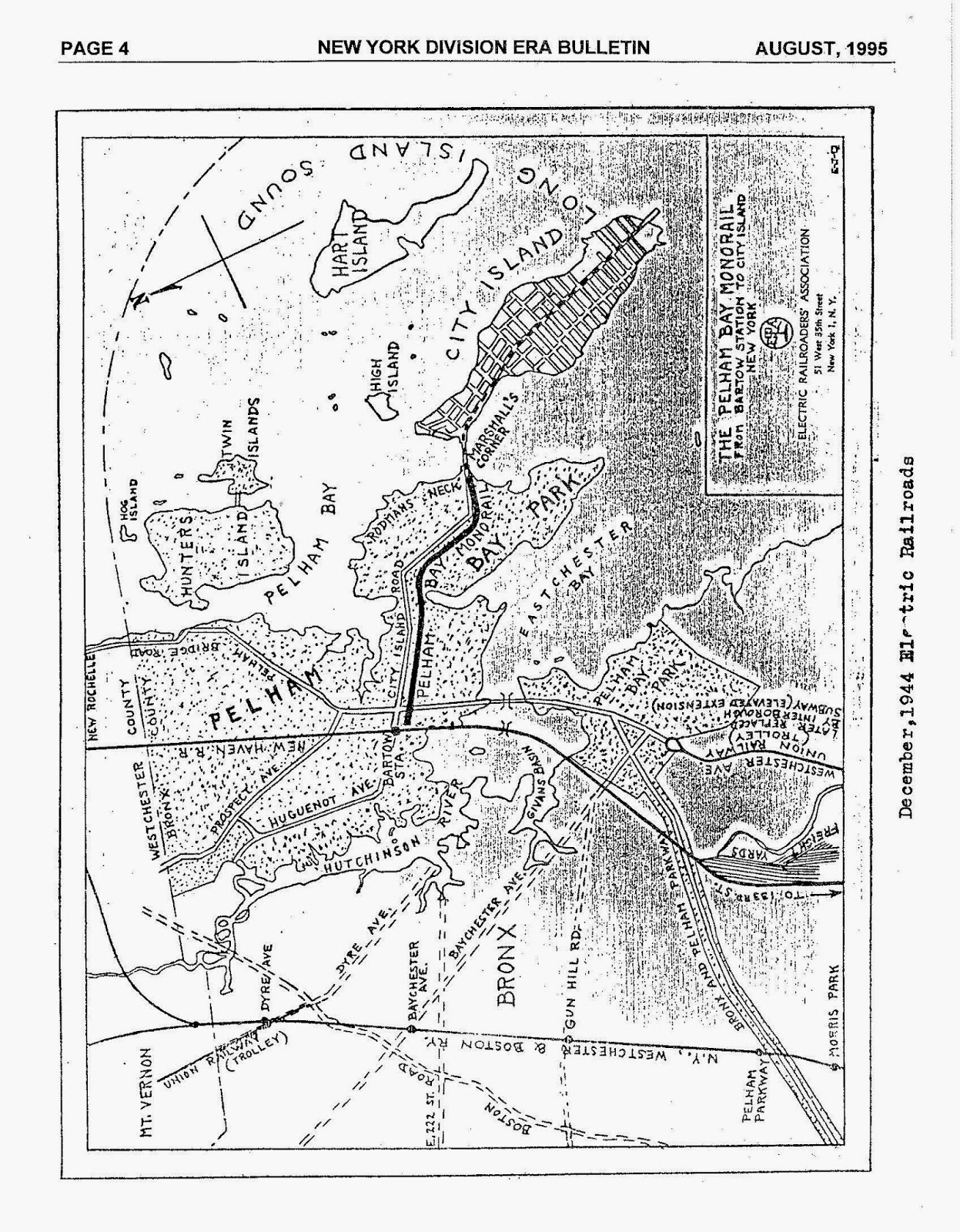
- There is a map at https://3.bp.blogspot.com/-u1gjvbcBch8/Uw6ToDReCuI/AAAAAAAADB8/LP_JPWcKvyw/s1600/PELHAM_MAP.jpg which shows the route of the railroad. Unfortunately, it's not usable due to licensing, but a new map could be drawn on a OSM base layer showing the same route. Note that the geography has changed significantly since the 1944 map was drawn; the area between Rodman's Neck and Hunter's Island was filled in to make Orchard Beach. The ruins of the old Bartow Station are shown on OSM as https://www.openstreetmap.org/way/249029872. What's labeled as "City Island Road" on the 1944 map is not what shows as City Island Road on modern maps. See File:Approximate Route of Pelham Park and City Island Railway.png for a rough sketch of the route on an OSM background layer, but this needs to be drawn more elegantly by somebody with better tools. -- RoySmith (talk) 00:51, 13 September 2021 (UTC)
- Discussion
- Just uploaded a draft, let me know what you think. Feel free to suggest any changes, especially to the scale. I couldn't get the overlay exactly perfect but I managed to line up the roads and railways and surrounding railwaysthis is as accurate as I could get it. Jcw12 (talk) 04:27, 13 September 2021 (UTC)
- Cool, thanks. This looks really nice. A dual miles/km distance scale would be an improvement. Also, now that I think about it, the article says,
Five days later operations were extended across the bridge to City Island and along City Island Avenue to Brown's Hotel. By 1892 the line had reached Belden's Point, its final terminal.
It would be nice if this could be extended to show the three different extents as the route grew over time (Marshall's Corner, Brown's Hotel, Belden Point). Belden Point is the southern-most tip of City Island Avenue. The problem is, I have no clue where Brown's Hotel was, so I need to do some research on that and get back to you. The part that you now have labeled "Pelham Bay Monorail" should be called "Pelham Park Railroad", and the part from Marshall's Corner to Belden Point should be "City Island Railroad", but maybe hold off on doing any more work until I can hunt down a location for Brown's Hotel. -- RoySmith (talk) 15:16, 13 September 2021 (UTC)
Closing given above {{resolved}}
Two maps of the Battle of Grunwald
-
 Possible locator map for background?
 -
 Map of entire campaign with "traditional" ending
 -

-


- Article(s)
- Battle of Grunwald
- Request
- Could some one create two maps for the army movements at end of the Grunwald campaign and initial positions of the units? One would be the "traditional" view and another the "new" view which was proven correct by archaeological excavations in 2014-2017. The two maps are here (pages 224 and 225). The new map in color is also here (page 257). The circles represent main camp locations. The new map places Teutonic camp (blue circle on the right) at 53°29′01″N 20°07′02″E / 53.483514°N 20.117244°E. The maps don't have to be super detailed or accurate, just enough to give the general idea. -- Renata•3 20:15, 18 September 2021 (UTC)
- Discussion
@Renata3: I don't really understand you request.
- You say pages 224 and 225 in this pdf but the first page is 239?
- Both these pages have copyright on them so I don't think we can use them to make "copies" of there maps but for information it should work.
- If you solve the page issue I could help but I will need your knowledge and help along the way. --always ping me-- Goran tek-en (talk) 17:27, 26 September 2021 (UTC)
- Hi Goran tek-en. Sorry, I meant pages 244 and 245. Yes, they are copyrighted maps, but I am hoping someone can create a free equivalent (possibly using the SVG locator map for background). I am happy to provide any assistance with interpreting the maps. If it helps any, the PDF used a version of this map for background (bottom right sheet). Renata•3 18:56, 26 September 2021 (UTC)
- Was working on the above maps before Goran tek-en mentioned the copyright issue - I'll admit I'm unsure of the copyright restrictions about it so it's worth checking up on it before using them in the article as they were 'traced' from the original. If they are ok to use, let me know if you'd like any changes/corrections. Or if you want to have a go Goran feel free. I've used an OpenStreetMap background because I found the locator map didn't look as good zoomed in, but I'm happy to re-make them using that if you'd prefer. Jcw12 (talk) 06:17, 27 September 2021 (UTC)
- Hi Goran tek-en. Sorry, I meant pages 244 and 245. Yes, they are copyrighted maps, but I am hoping someone can create a free equivalent (possibly using the SVG locator map for background). I am happy to provide any assistance with interpreting the maps. If it helps any, the PDF used a version of this map for background (bottom right sheet). Renata•3 18:56, 26 September 2021 (UTC)
- Thanks @Renata3: for that info. I couldn't see that you @Jcw12: had "taken" this request as it didn't show that. I will do nothing here if I don't hear from you again Renata3, thanks. --always ping me-- Goran tek-en (talk) 09:02, 27 September 2021 (UTC)
- HI Jcw12, thank you so much! May I request a couple of changes?
- The "modern" map looks good. I would only ask to add one thing -- some sort of sign/symbol for the location of the memorial site which is at 53°29′14″N 20°07′24″E / 53.48710°N 20.12321°E. Also, I would remove the caption at the top of the image -- those kind of things should really be communicated via image captions in articles. Plus without a large English caption, the map is more friendly to other language Wikipedias.
- The "traditional" map seems a little off in army movement. Can the arrows be adjusted? The Polish-Lithuanian camp should be near the corner of the little lake Lubien (closer to 53°28′14″N 20°11′10″E / 53.470526°N 20.186007°E). Also, the Polish-Lithuanian army seems to be marching right through that little lake, when they should go a little around it. As a result of "marching thru the lake", the whole battle line is a little too north (the line extends a little too far off Stebark/Tannenberg). Also, if you could make the same two adjustments as in the "modern" map -- add symbol for the memorial site and get rid of the caption at the top.
- Again, thank you! Appreciate your help :) Renata•3 01:36, 28 September 2021 (UTC)
- No problem - Happy to help, it's really interesting to be exposed to history I otherwise wouldn't know about so thanks for that :). Also thanks for the feedback - I added the adjustments you mentioned - let me know if I've missed anything or if there's anything else I should change.Jcw12 (talk) 03:15, 28 September 2021 (UTC)
{{resolved}}
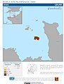
New Providence Island, Bahamas (+ potential for more?)
{{Resolved}}
Request
- Hi! I was wondering if it would be possible to get some more maps that are zoomed in on New Providence (see category on Commons) (with potential for more islands) in the Bahamas. For example: when you put in the coordinates (like on Bonefish Pond National Park), because the islands are so spread out and tiny, it's hard to make out the location on the Bahamas-wide SVG map. I'm new to the map side of things so I hope I'm making sense. – Starklinson 10:28, 17 September 2021 (UTC)
- Discussion
@Starklinson: Have you considered using the {{maplink}}? This will create a dynamic map that allows the user to zoom/pan. There is a need for more location maps in this area. If you would like to discuss this topic, please ping me. - DutchTreat (talk) 14:48, 21 September 2021 (UTC)
 Done Looks like you found related template for Bonefish Pond National Park. Let me know if you have more questions. DutchTreat (talk) 16:12, 26 September 2021 (UTC)
Request for an area map for the sea area known as the Bay of Granville where there's a current fisheries dispute between Britain and France
-
 This left side of this map covers the area needed
 -
 Or this one
 -


.jpg)

- Article(s)
- 2021 Jersey dispute
- Request
- I brought 2021 Jersey dispute up to GA standard. Commons has various maps showing the location of the island of Jersey and the adjacent coasts of France. What this article needs is to show label the location of:
- Saint Helier harbour on Jersey
- two ports on the Normandy coast - Barneville-Carteret, Granville, Manche
- one port in Brittany - Saint-Malo
- two uninhabited reefs - the Minquiers and Écréhous
- outline of the three and twelve mile limits of territorial sea around Jersey - there are various sources but this one is probably the simplest
Any help gratefully received! Curb Safe Charmer (talk) 15:03, 27 September 2021 (UTC)
- Discussion
I'll give it a go and upload a draft later today/tomorrow ![]() Request taken by Jcw12 (talk) 01:33, 28 September 2021 (UTC).
Request taken by Jcw12 (talk) 01:33, 28 September 2021 (UTC).
- Just put up a draft, let me know what you think/anything Ive missed or I should change Jcw12 (talk) 06:11, 28 September 2021 (UTC).
- @Jcw12: That is great! Thank you so much. It will make the article much clearer. Curb Safe Charmer (talk) 17:05, 28 September 2021 (UTC)
{{Resolved}}
Faroe Islands isoglosses and main dialects
-
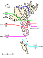 Isoglosses of the Faroe Islands
 -
 Isoglosses and Main Dialects


- Article(s)
- Request
- Can someone kindly create vector versions of these maps. Data seems to be from page 398 of the book Faroese. An Overview and Reference Grammar, but I don't have access to that book and can't verify how accurate these are to the original. – Heimasími (talk) 03:51, 7 August 2021 (UTC)
- Discussion
- Heimasími I might get around to working on this tomorrow, based of File:Faroe Islands location map.svg. If someone else wants to have a go in the meantime feel free. — Berrely • Talk∕Contribs 19:12, 8 August 2021 (UTC)
Request Orthographic map of Indonesia 1982
-
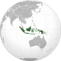 for the Indonesian map
 -
 map of the world in the 80s
.svg)

- Article(s)
- New Order
- Request
- I already asked for this at the request map, in case I was in the wrong place, maybe someone here can help me
- Can someone add World map in the 80s for this Indonesian map (in svg)? plus add East Timor into indonesia map in light green (#49C946) color.… -- Mhatopzz (talk) 09:44, 19 August 2021 (UTC)
- Discussion
Mhatopzz (talk) 09:34, 19 August 2021 (UTC)
World Map of nations
- Article(s)
- Land tenure
-
 Countries where foreign land ownership is banned
 -
 Countries where foreign land ownership is banned


- Request
- Hi i am just wondering can sombody make a world map of nations which ban foreigners from owning land. these are the nations that ban foreigners from owning land.
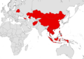
:1.China :2.Thailand, <ref>https://www.thailandlawonline.com/thai-real-estate-law/ownership-and-buying-real-estate-in-thailand</ref> :3.Philippines, <ref>https://www.manilastandard.net/opinion/columns/footnotes-by-tranquil-g-s-salvador-iii/350395/can-foreigners-own-land-in-the-philippines-.html</ref><ref>https://oxfordbusinessgroup.com/overview/real-estate-transaction-rules-look-key-regulations-real-estate-transactions</ref><ref>https://www.dayananconsulting.com/foreign-ownership-land-philippines/</ref> :*indonesia, <ref>https://www.globalpropertyguide.com/Asia/Indonesia/Buying-Guide</ref><ref>https://www.balirealty.com/foreign-ownership-of-land-and-property-in-indonesia/</ref> :4 Vietnam, <ref>https://vietnaminsider.vn/can-foreigner-buy-property-in-vietnam/</ref><ref>https://www.asiapropertyhq.com/buy-property-vietnam/</ref> :5.Burma, ref>https://www.retalkasia.com/news/2017/03/21/buying-property-myanmar/1490067561</ref> :6.Belarus, <ref>https://en.lsl.by/how-can-a-foreigner-buy-property-in-belarus/</ref><ref>https://www.globalpropertyguide.com/Europe/Belarus</ref> :*Laos, <ref>https://www.lexology.com/library/detail.aspx?g=387a95d8-6e8f-46e2-a912-f600227488fe</ref><ref>https://www.investasian.com/2017/08/10/invest-in-laos/</ref> :7.Mongolia,<ref>http://www.anallp.com/index.php/index/article/aid/199.html#:~:text=Only%20Mongolian%20citizens%20can%20own,is%200.5%20hectares%20of%20land.</ref> <ref>https://www.retalkasia.com/news/2017/03/01/buying-property-mongolia/1488333808</ref><ref>https://www.mongolia-properties.com/faqs</ref> :8.Georgia, <ref>https://www.reuters.com/article/us-georgia-landrights-agriculture-idUSKCN1RT03Y</ref><ref>https://eurasianet.org/georgia-keeping-its-land-off-limits-for-foreigners</ref><ref>http://www.fao.org/3/y5026e/y5026e09.htm</ref><ref>https://oc-media.org/georgia-temporarily-lifts-ban-on-sale-of-agricultural-land-to-foreign-citizens/</ref> :9 Kazakhstan, <ref>https://www.rferl.org/a/kazakhstan-ban-on-foreigners-owning-land-becomes-law/31252826.html</ref><ref>https://thediplomat.com/2021/05/kazakhstan-bans-sale-of-agricultural-lands-to-foreigners/</ref><ref>https://www.reuters.com/article/us-kazakhstan-farming-land-ownership-idUSKBN2AP0MU</ref> :*10 Afghanistan, <ref>https://law.stanford.edu/wp-content/uploads/2017/10/ALEP-Property-Law-1st-Ed_English.pdf</ref><ref>https://www.isprs.org/proceedings/XXXVIII/1_4_7-W5/paper/Khan-112.pdf</ref><ref>https://www.constituteproject.org/constitution/Afghanistan_2004.pdf?lang=en</ref> :11 Maldives, <ref>https://www.reuters.com/article/us-maldives-land-idUSKCN1RU0MZ</ref><ref>https://realty.economictimes.indiatimes.com/news/industry/maldives-parliament-repeals-law-allowing-foreign-land-ownership/68941048</ref> :12 Cambodia, <ref>https://ips-cambodia.com/can-foreigners-own-land-in-cambodia-heres-how/</ref> <ref>https://www.juwai.asia/main/news/3030</ref> thanks. La lopi (talk) 04:27, 2 August 2021 (UTC)
- Discussion
- I added two, one wider and one closer above, feel free to choose one or if there's any changes you'd like made let me know Jcw12 (talk) 02:59, 24 August 2021 (UTC)
- Hi thanks for doing the map, while i was looking at it i found it didn't have the following nations, Vietnam, Burma, Philippines and Mongolia other then that it was good. thanks. La lopi (talk) 14:45, 24 August 2021 (UTC)
Thanks for that update, Isreal is another nation that bans foreign ownership of land. you can add it on the map. La lopi (talk) 07:16, 25 August 2021 (UTC)
Request: World map of Flag desecration laws
- Article(s)
- Flag desecration
-
 Flag Desecration Legality by Nation
 -
 Flag Desecration Legality by Nation.


- Request
- Hi am just wondering can sombody make a world map of laws on Flag desecration. The map should have 3 colours 1 Red (for Nations which ban Flag desecration only for their own nation) these nations are the following Algeria, Argentina, China, Finland,France and Turkey.
A other colour (for Nations which ban Flag desecration for their own nation and other foreign nations) these are the following nations, Israel, Germany and Austria.
And a other colour (for Nations which ban Flag desecration for foreign nations but not their own) these are the following nations, Denmark and Japan. thanks.La lopi (talk) 07:03, 23 August 2021 (UTC)
- Discussion
- Found that the list you provided didn't contain everything on the page so I included all I could find, plus one for those where it's actively legal. Also included one with and one without key for you to choose from. Let me know if you want me to change anything, Thanks, Jcw12 (talk) 08:35, 25 August 2021 (UTC)
- Thanks for that, this too looks good. i will take some time looking at other nations laws on this matter. i will give you an update soon.La lopi (talk) 14:00, 25 August 2021 (UTC)
I had a fast look and i would say that New Zealand should be taken down and be put in unknown or legal for flag desecration. becouse they had two cases where the person who done it had their convictions overturned due to so called freedom of expression. La lopi (talk) 14:14, 25 August 2021 (UTC)
This appears to be {{resolved}}
Legality of bitcoin by country or territory
-
 The map

- Article(s)
- Legality of bitcoin by country or territory
- Request
- Please change the color of China on the map from pink (meaning "contentious due to old laws from before Bitcoin was invented") to red (meaning "banned") as starting today, China bans all cryptocurrencies, including bitcoin https://www.ndtv.com/business/china-cryptocurrency-ban-news-chinas-central-bank-rules-all-crypto-transactions-are-illegal-2552286. I'm not sure if this will affect Hong Kong or Macau as both those cities have different economies with different financial laws not only from Mainland China but also each other (Hong Kong allowed Bitcoin since 2014 but Macau has never explicitly stated whether it's legal or not to use Bitcoin in Macau). Thanks in advance. --109.78.162.140 (talk) 14:43, 24 September 2021 (UTC)
- Discussion
![]() Done CMD (talk) 15:50, 24 September 2021 (UTC)
Done CMD (talk) 15:50, 24 September 2021 (UTC)
- Given no further updates, marking this as {{resolved}}