
Torpo Stave Church


Torpo Stave Church (Norwegian: Torpo stavkyrkje) is a stave church located in Torpo, a small village in Ål municipality in Buskerud county, Norway. Torpo is located along Norwegian National Road 7, the Norwegian national road which runs between Oslo and Bergen.[1]
History[edit]
Built in 1192, the Torpo Stave Church is the oldest building within the valley and traditional district of Hallingdal. The church was dedicated to Saint Margareta. The stave church was purchased by the municipality in 1875. It was initially planned to expand it with an annex to the east, but in 1879 it was decided instead to modernize the interior with new ceiling and gallery. Following protest from the Ancient Monuments Society (Fortidsminneforeningen), the municipality decided to build a new church (Torpo Kyrkje) on the adjacent property. The new church was built north of the old one with the two churches standing side by side.[2][3]
Runic inscription N 110[edit]
The Torpo Stave Church is one of two stave churches that are signed by their craftsmen, the other being the church at Ål. In both churches a runic inscription reads: Thorolf built this church.[4] The full runic inscription in the Torpo Stave Church, which is listed as N 110 in the Rundata catalog, reads:
- §A þorolfr : gærþi : kirku þesa ÷: askrimr ÷ hakon ÷ ælikr ÷ pal ¶ æinriþi ÷ siønti ÷ þorolfr
- §B þorer ÷ ræist
- §C olafr[5]
This translates as "Þórolfr made this church. Ásgrímr, Hákon, Erlingr, Páll, Eindriði, Sjaundi, Þórulfr. Þórir carved. Ólafr."[5]
Gallery[edit]
-
 Torpo Stave Church
Main portal -
 Torpo Stave Church
South portal -
 Torpo Stave Church
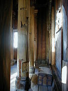
Interior -
 Torpo Stave Church
Interior -
 Torpo Stave Church
Interior detail -
 Torpo Stave Church
Exterior -
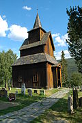 Torpo Stave Church
Exterior -
 Torpo Church and Torpo Stave Church (1880–1890)


References[edit]
- ^ "Torpo stavkirke (Olavsrosa)". Archived from the original on 16 July 2011. Retrieved 10 July 2010.
- ^ Torpo Kirke (Norsk Institutt for kulturminneforskning)[permanent dead link]
- ^ Middelaldermaleriet i Torpo stavkirke (University of Oslo, 2007)[permanent dead link]
- ^ "Ål kommune: Torpo stavkirke / Torpo Stabkirche og Torpo kyrkje (Bilder av stavkirken)". Archived from the original on 22 June 2011. Retrieved 10 July 2010.
- ^ a b Project Samnordisk Runtextdatabas Svensk Archived 7 August 2011 at the Wayback Machine – Rundata entry for N 110.
Further reading[edit]
- Bugge Gunnar. Stavkirker, Stave Churches in Norway (Dreyers Forlag. Oslo: 1983) ISBN 82-504-2072-1
- Christie, Sigrid and Haakon. Norges kirker – Buskerud (Norske Mindesmerker. Oslo: 1981) ISBN 82-05-13123-6
- Dietrichson, Lorentz. Norske Stavkirker: Studier Over Deres System, Oprindelse Og Historiske Udvikling (Kristiania: 1892) New edition: (Gregg Publishing; 1971) ISBN 0-576-19100-0
- Leif Anker (2005) The Norwegian Stave Churches (Oslo: Arfo Forlag) ISBN 978-8291399294
External links[edit]

| International | |
|---|---|
| Artists | |