
Titov Vrv
| Titov Vrv | |
|---|---|
| Turk i Madh Golem Turčin (former name) | |
 View of Titov Vrv (left) and Mal Turčin (right) | |
| Highest point | |
| Elevation | 2,748 m (9,016 ft) |
| Coordinates | 41°59′31″N 20°47′53″E / 41.99194°N 20.79806°E |
| Geography | |
 Titov Vrv Location of the peak | |
| Location | North Macedonia |
| Parent range | Šar Mountain |
Titov Vrv (Macedonian: Титов Врв, lit. 'Tito's Peak'; Albanian: Turku i Madh, lit. 'Big Turk') is the highest peak of the Šar Mountains at 2,748 m (9,016 ft). It is located about 13 mi (21 km) northwest of the city of Tetovo in North Macedonia, near the border with Kosovo.
Name[edit]
The summit's original name is "Big Turk" (Macedonian: Голем Турчин, romanized: Golem Turčin). In 1934, the peak was renamed to Mount Aleksandar, in honor of Aleksandar I of Yugoslavia, after his assassination. During World War II, the Bulgarian authorities restored its original name. The peak was renamed in 1953 in honor of Josip Broz Tito. The name has remained unchanged since Macedonian independence in 1991, however in other neighboring languages such as Turkish, Albanian, and Bulgarian it is still known as the "Big Turk". Тhe smaller neighboring peak is known as "Small Turk" (Macedonian: Мал Турчин, romanized: Mal Turčin).[1]
Activity[edit]
Every year, on the last weekend of May, the Ljuboten mountain club holds a climb to this peak.[2]
In December 2022, the inside of the tower at the top of the peak was vandalized.[3]
Gallery[edit]
-
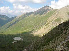 View of Titov Vrv, with Lake Krivošijsko in the foothills
 -
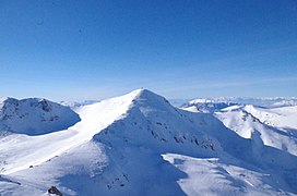 View of Titov Vrv from Bakardan
 -
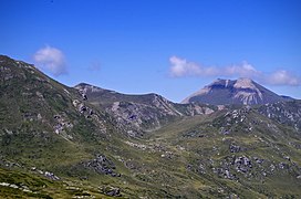 View of Titov Vrv from Mal Turčin
 -
 Tower at the top of the peak
.JPG)
_10.jpg)

_08.jpg)
See also[edit]
References[edit]
- ^ Tomasz Pezold, All along the watchtowers: field guide for the south eastern European Green Belt; IUCN, 2009, ISBN 2831711363, p. 12.
- ^ Makfax Independent News Agency (in Macedonian)
- ^ "Освен прозорците, демолирана целата внатрешност на планинарската кула на Титов Врв". kanal5.com.mk (in Macedonian). Retrieved 2022-12-25.
This North Macedonia location article is a stub. You can help Wikipedia by expanding it. |