
Tidan (river)
You can help expand this article with text translated from the corresponding article in Swedish. (January 2022) Click [show] for important translation instructions.
|
| Tidan | |
|---|---|
 Historical covered bridge | |
 Course of Tidan running north | |
| Location | |
| Country | Sweden |
| County | Västra Götaland County |
| Physical characteristics | |
| Mouth | Vänern |
• location | Mariestad, Västra Götaland County |
• coordinates | 58°42′50″N 13°49′00″E / 58.71389°N 13.81667°E |
• elevation | 44 m (144 ft) |
| Length | 140 km (87 mi)[1] |
| Basin size | 2,230 km2 (860 sq mi)[1] |
| Discharge | |
| • average | 20 m3/s (710 cu ft/s)[1] |
Tidan is a river in Sweden. It is one of few Swedish rivers that flow north. The river can be canoed from Bottnaryd (57°46′21″N 13°50′33″E / +57.7724°N +13.8426°E) to Mariestad (58°41′32″N 13°49′30″E / +58.6921°N +13.8249°E), a trip that takes 7–10 days.
Gallery[edit]
-
 Canoe portage on the Tidan River using timber skids, nearby to road bridge F1838
 -
 Tidan River in Ettaks strömmar nature reserve, looking upstream with service bridge in background
 -
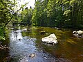
 Tidan River looking upstream from east bank in Ettaks strömmar nature reserve
 -
 Canoeing the Tidan River near Lagerfors
 -
 Historic covered bridge on the Tidan River
 -
 Cows grazing on banks of the Tidan River, within the bounds of the Östens naturreservat
 -
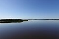
 Lake Östen, a nature reserve in Sweden, looking approximately west
 -
 Lake Östen, a nature reserve on the Tidan River


References[edit]
- ^ a b c "Tidan". Nationalencyklopedin (in Swedish). Retrieved 16 July 2010. (subscription required)