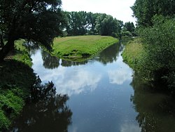
Template:Infobox Fluss/testcases
River Test[edit]
| River Test | |
|---|---|
 Test | |
 | |
| Location | |
| State | Lower Saxony, Germany |
| Reference no. | CH: 5, DE: 2 |
| Physical characteristics | |
| Source | |
| • location | Source: At Quellstadt as a result of the confluence of Yellbach and Zillbach |
| • coordinates | 50°08′08″N 9°09′09″E / 50.13556°N 9.1525°E |
| • elevation | ca. 1,000 m above the sea (Quellbach) |
| Mouth | |
• location | Mouth: At Mundstadt into the River Wiese |
• coordinates | 48°47′46″N 9°18′36″E / 48.79611°N 9.31°E |
• elevation | about 400 m above sea level (NN) (X-Arm) |
| Length | 100 km [1] |
| Basin size | 1,000 km² [1] |
| Discharge | |
| • location | at Pegeldorf gauge[1] |
| • average | 50 m³/s |
| • minimum | Record low: 1 m³/s (in 1980) Average low: 5 m³/s |
| • maximum | Average high: 150 m³/s Record high: 250 m³/s (in 2005) |
| Basin features | |
| Progression | River1 → River2 → Sea |
| River system | River system |
| Landmarks |
|
| Population | 1,000,000 |
| Tributaries | |
| • left | Aabach, Bebach |
| • right | Cebach, Debach |
| Waterbodies |
|
| Bridges | Test Bridge at Mittburg |
| Inland ports | Grossburg Port |
| Navigable | only during rainy season |
Remarks  World map | |
