
St Peter's Square tram stop
St Peter's Square | ||||||||||||||||||||||||||||||||||||||||||||||||||||||||||||||||||||||||||||||||||||||||||||||||||||||||||||||||||||||||||||||
|---|---|---|---|---|---|---|---|---|---|---|---|---|---|---|---|---|---|---|---|---|---|---|---|---|---|---|---|---|---|---|---|---|---|---|---|---|---|---|---|---|---|---|---|---|---|---|---|---|---|---|---|---|---|---|---|---|---|---|---|---|---|---|---|---|---|---|---|---|---|---|---|---|---|---|---|---|---|---|---|---|---|---|---|---|---|---|---|---|---|---|---|---|---|---|---|---|---|---|---|---|---|---|---|---|---|---|---|---|---|---|---|---|---|---|---|---|---|---|---|---|---|---|---|---|---|---|
| Manchester Metrolink tram stop | ||||||||||||||||||||||||||||||||||||||||||||||||||||||||||||||||||||||||||||||||||||||||||||||||||||||||||||||||||||||||||||||
.jpg) | ||||||||||||||||||||||||||||||||||||||||||||||||||||||||||||||||||||||||||||||||||||||||||||||||||||||||||||||||||||||||||||||
| General information | ||||||||||||||||||||||||||||||||||||||||||||||||||||||||||||||||||||||||||||||||||||||||||||||||||||||||||||||||||||||||||||||
| Location | St Peter's Square, Manchester England | |||||||||||||||||||||||||||||||||||||||||||||||||||||||||||||||||||||||||||||||||||||||||||||||||||||||||||||||||||||||||||||
| Coordinates | 53°28′42″N 2°14′35″W / 53.4782°N 2.2430°W | |||||||||||||||||||||||||||||||||||||||||||||||||||||||||||||||||||||||||||||||||||||||||||||||||||||||||||||||||||||||||||||
| Grid reference | SJ839979 | |||||||||||||||||||||||||||||||||||||||||||||||||||||||||||||||||||||||||||||||||||||||||||||||||||||||||||||||||||||||||||||
| Line(s) | First City Crossing Second City Crossing | |||||||||||||||||||||||||||||||||||||||||||||||||||||||||||||||||||||||||||||||||||||||||||||||||||||||||||||||||||||||||||||
| Platforms | 4 | |||||||||||||||||||||||||||||||||||||||||||||||||||||||||||||||||||||||||||||||||||||||||||||||||||||||||||||||||||||||||||||
| Other information | ||||||||||||||||||||||||||||||||||||||||||||||||||||||||||||||||||||||||||||||||||||||||||||||||||||||||||||||||||||||||||||||
| Status | In operation | |||||||||||||||||||||||||||||||||||||||||||||||||||||||||||||||||||||||||||||||||||||||||||||||||||||||||||||||||||||||||||||
| Fare zone | 1 | |||||||||||||||||||||||||||||||||||||||||||||||||||||||||||||||||||||||||||||||||||||||||||||||||||||||||||||||||||||||||||||
| History | ||||||||||||||||||||||||||||||||||||||||||||||||||||||||||||||||||||||||||||||||||||||||||||||||||||||||||||||||||||||||||||||
| Original company | Manchester Metrolink | |||||||||||||||||||||||||||||||||||||||||||||||||||||||||||||||||||||||||||||||||||||||||||||||||||||||||||||||||||||||||||||
| Key dates | ||||||||||||||||||||||||||||||||||||||||||||||||||||||||||||||||||||||||||||||||||||||||||||||||||||||||||||||||||||||||||||||
| 27 April 1992 | Opened | |||||||||||||||||||||||||||||||||||||||||||||||||||||||||||||||||||||||||||||||||||||||||||||||||||||||||||||||||||||||||||||
| ||||||||||||||||||||||||||||||||||||||||||||||||||||||||||||||||||||||||||||||||||||||||||||||||||||||||||||||||||||||||||||||
| ||||||||||||||||||||||||||||||||||||||||||||||||||||||||||||||||||||||||||||||||||||||||||||||||||||||||||||||||||||||||||||||

St Peter's Square is a tram stop in St Peter's Square in Manchester city centre, England. It opened on 27 April 1992 and is in Zone 1 of Greater Manchester's Metrolink light rail system.
The stop's platforms were extended in 2009, but later redevelopment in 2015–16 demolished the original two side platforms and replaced them with a twin-island platform layout, which allows for limited cross-platform interchange. The stop is the most used on the Metrolink network.[1]
History[edit]
Plans for a rapid transit station in St Peter's Square were made in the 1970s; proposals for the abandoned Picc-Vic tunnel envisaged the construction of an underground station to serve both St Peter's and the neighbouring Albert Square.[2] The early proposals for an on-street light rail system in Manchester revived the idea of a station in the square. St. Peter's Square was one of the original city-centre stops to open when Metrolink started operations in 1992, when it consisted of two side platforms and basic shelters. In common with most newly built Metrolink stops at the time, St. Peter's Square had two-level platforms, meaning only a short section of the platforms offered level boarding.
The stop was demolished and rebuilt with a full length platform and improved passenger facilities in November 2009. When a building called Elisabeth House, which had stood between Dickinson Street and Oxford Street since the 1970s, was demolished for redevelopment in 2011 as One St Peter's Square,[3] architects' plans were entered in a competition, which was modified in 2011 to incorporate proposals to improve the Metrolink station. In March 2012 a shortlist of two submissions was made.[4]
The stop closed after end of service on 27 June 2015 for 14 months to allow for a total redevelopment to incorporate trams on the new Second City Crossing.[5] The tram stop re-opened on 28 August 2016 as a four-platform interchange, comprising two island platforms, one for inbound services and the other for outbound. This offers same-direction cross-platform interchange. The stop was moved slightly north towards Princess Street from that of its old location, which was in front of Manchester Central Library. A number of trees were planted within the structure of the platforms to improve the look and feel of the space.[6] The Manchester Cenotaph was also relocated and the entire square has been redeveloped into a new public space. During the redevelopment works, a reduced service ran through the square on a single track[7] from Nicholas Street to Windmill Street[8] - but there were two 2-month long closures at the beginning and end of the project.[9] During these full closures, no Metrolink services ran through the square. The rebuilding work uncovered the remnants of an 18th century church crypt.[10]
Deansgate-Castlefield – St Peter's Square | ||||||||||||||||||||||||||||||||||||||||||||||||||||||||||||||||||||||||||||||||||||||||||||||||||||||||||||||||||||||||||||||||||||||||||||||||||||||||||||||||
|---|---|---|---|---|---|---|---|---|---|---|---|---|---|---|---|---|---|---|---|---|---|---|---|---|---|---|---|---|---|---|---|---|---|---|---|---|---|---|---|---|---|---|---|---|---|---|---|---|---|---|---|---|---|---|---|---|---|---|---|---|---|---|---|---|---|---|---|---|---|---|---|---|---|---|---|---|---|---|---|---|---|---|---|---|---|---|---|---|---|---|---|---|---|---|---|---|---|---|---|---|---|---|---|---|---|---|---|---|---|---|---|---|---|---|---|---|---|---|---|---|---|---|---|---|---|---|---|---|---|---|---|---|---|---|---|---|---|---|---|---|---|---|---|---|---|---|---|---|---|---|---|---|---|---|---|---|---|---|---|---|
| ||||||||||||||||||||||||||||||||||||||||||||||||||||||||||||||||||||||||||||||||||||||||||||||||||||||||||||||||||||||||||||||||||||||||||||||||||||||||||||||||
-
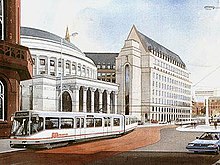 An artist's impression of light rail in St Peter's Square (1987)
 -
 T-68 Tram at the old St Peter's Square tram stop in 1992.
 -
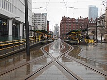 The rebuilt four platform stop, 2018


Services[edit]
Services run every 12 minutes on each route.
| Preceding station | Following station | |||
|---|---|---|---|---|
| Deansgate-Castlefield towards East Didsbury
|
East Didsbury–Shaw (peak only) | Exchange Square towards Shaw and Crompton
| ||
| East Didsbury–Rochdale | Exchange Square towards Rochdale Town Centre
| |||
| Deansgate-Castlefield towards Manchester Airport
|
Manchester Airport–Victoria | Market Street towards Victoria
| ||
| Deansgate-Castlefield towards Altrincham
|
Altrincham–Bury (peak only) | Market Street towards Bury
| ||
| Altrincham–Piccadilly | Piccadilly Gardens towards Piccadilly
| |||
| Altrincham–Etihad Campus (evenings and Sundays only) | Piccadilly Gardens towards Etihad Campus
| |||
| Deansgate-Castlefield towards Eccles
|
Eccles–Ashton (peak only) | Piccadilly Gardens towards Ashton-under-Lyne
| ||
| Eccles–Ashton via MediaCityUK (off-peak only) | ||||
| Deansgate-Castlefield towards MediaCityUK
|
MediaCityUK–Etihad Campus (peak only) | Piccadilly Gardens towards Etihad Campus
| ||
References[edit]
- ^ "Transport Statistics Greater Manchester 2017 Public Transport Section". TfGM. 5 December 2019. Retrieved 14 December 2019.
- ^ SELNEC PTE (October 1971), SELNEC Picc-Vic Line, SELNEC PTE publicity brochure
- ^ "Elizabeth House". Cool Manchester. Retrieved 24 March 2012.
- ^ One St Peter's Square; E-architect
- ^ "St Peter's Square Metrolink stop to reopen after a year". BBC News. 27 August 2016. Archived from the original on 28 August 2016. Retrieved 14 March 2020.
- ^ "One month to go for St Peter's Square tram works". Place North West. 27 July 2016. Archived from the original on 28 July 2016.
- ^ "Next stop, St. Peter's Square" (PDF). 8 April 2016. Archived from the original (PDF) on 4 August 2016. Retrieved 15 March 2020.
- ^ GM Trainspotting (26 June 2016). Metrolink Driver's Eye View - Market Street to Deansgate-Castlefield. Retrieved 18 May 2024 – via YouTube.
- ^ "St Peter's Square stop closure: Metrolink and shuttle bus services". Transport for Greater Manchester. TfGM. 29 June 2015. Archived from the original on 8 August 2015.
- ^ Helen Heath (15 February 2017). "Bishop of Manchester rededicates cross in St Peter's square". thenorthernquota.org. Retrieved 14 March 2020.
External links[edit]
- Tram times and station information for St Peter's Square Metrolink station from Manchester Metrolink
- St Peter's Square area map
Manchester railways |
|---|
City Centre and North
Past, present and future |
| Tram stops |
|   | ||||||||||||||||||||||||
|---|---|---|---|---|---|---|---|---|---|---|---|---|---|---|---|---|---|---|---|---|---|---|---|---|---|---|
| Operations |
| |||||||||||||||||||||||||
| History (Timeline) |
| |||||||||||||||||||||||||
| Proposed developments |
| |||||||||||||||||||||||||
- Tram stops in Manchester
- Railway stations in Great Britain opened in 1992
- Tram stops on the Eccles – Ashton route
- Tram stops on the East Didsbury – Shaw route
- Tram stops on the East Didsbury – Rochdale route
- Tram stops on the Altrincham – Bury route
- Tram stops on the Altrincham – Piccadilly/Etihad Campus route
- Tram stops on the Manchester Airport – Victoria route
- Tram stops on the MediaCityUK – Etihad Campus route