
Shinuhayr
Shinuhayr
Շինուհայր | |
|---|---|
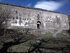
 Medieval monastery Kusanats Anapat in Shinuhayr | |
 Shinuhayr  Shinuhayr | |
| Coordinates: 39°26′03″N 46°18′56″E / 39.43417°N 46.31556°E | |
| Country | Armenia |
| Province | Syunik |
| Municipality | Tatev |
| Area | |
| • Total | 30.56 km2 (11.80 sq mi) |
| Population | |
| • Total | 2,661 |
| • Density | 87/km2 (230/sq mi) |
| Time zone | UTC+4 (AMT) |
| Shinuhayr at GEOnet Names Server | |
Shinuhayr (Armenian: Շինուհայր) is a village in the Tatev Municipality of the Syunik Province in Armenia, 9 km south of Goris, on the left bank of the Vorotan River, on the plateau, about 1500 meters above sea level. The distance from the province center of Kapan is about 68 km.
The village under the name of Shinher was included in the Zangezur uezd within the Elizavetpol Governorate of Russian Empire. During the Soviet years, it was part of the Zangezur province of the Armenian SSR, and from 1930, it was part of the Goris region. Since 1995, it has been part of the Syunik province of RA, since 2015 it is part of the enlarged Tatev community, is the largest settlement and center of the community.
The currently inoperative Goris Airport, also known as Shinuhayr Airport, is located in the village.
History[edit]
Shinuhayr is first mentioned in written sources in the beginning of the 10th century.[3] In Stepanos Orbelian's History of the Province of Syunik the tax of the village is set at 24, which proves that Shinuhayr was one of the largest villages not only of Haband province, but also of Syunik as a whole.[4] Perhaps with this in mind, some authors later used the forms of Shinu hayr or Hayrashen, that is, 'the father of villages'. However, Orbelian uses only two forms: Shnher and Shinoi Herk. The form Shner is used also in historical inscriptions.
Shnher first belonged to Prince Filipe of Syunik, who then donated it to Tatev Monastery, which was re-established by Prince Tarsayich Orbelian in 1274. The village remained the property of the monastery until the beginning of the 19th century.[3]
During the Syunik rebellion in the 1720s, the Armenian military leader Davit Bek made Shinuhayr his first base of operations and began repairing the settlement's fortress.[5]
Demographics[edit]
Population[edit]
The Statistical Committee of Armenia reported its population was 2,865 in 2010,[6] up from 2,593 at the 2001 census.[7]
Economy[edit]
The population is engaged in vegetable farming, cultivation of grain and fodder crops.
Gallery[edit]
-
 Kusanats Anapat
 -
 Saint Stepanos church in Hin Shinuhayr
 -
 WWII monument
 -
 Hin Shinuhayr
 -
 Panorama from Shinuhayr village and Vorotan canyon
 -
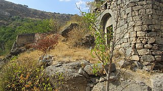 The entrance to the monastery


.jpg)
References[edit]
- ^ "Syunik regional e-Governance System" (in Armenian). Syunik Province provincial government. Click on link entitled "Համայնքներ" (community) and search for the place by Armenian name.
- ^ Statistical Committee of Armenia. "The results of the 2011 Population Census of Armenia" (PDF).
- ^ a b Barkhudarian, S. G. (1960). Divan hay vimagrutʻyan Դիվան հայ վիմագրության [Collection of Armenian epigraphs] (in Armenian). Vol. 2. Yerevan: HSSṚ GA hratarakchʻutʻyun. pp. 55.
- ^ Orbelian, Stepanos (1986). Syunikʻi patmutʻyun Սյունիքի պատմություն [History of Syunik] (in Armenian). Yerevan: Sovetakan grogh.
- ^ Hovhannisyan, P. H. (2012). "Hay azatagrakan sharzhumnerě XVIII darum" Հայ ազատագրական շարժումները XVIII դարում [The Armenian liberation movements in the 18th century]. In Simonyan, Hr. R. (ed.). Hayotsʻ patmutʻyun: Hnaguyn zhamanakneritsʻ minchʻev mer orerě Հայոց պատմություն։ Հնագույն ժամանակներից մինչև մեր օրերը [History of Armenia: From ancient times until our days] (PDF) (in Armenian). Yerevan State University Publishing House. pp. 236–237. ISBN 978-5-8084-1639-0.
- ^ "Marzes of Armenia and Yerevan City in Figures, 2010" (PDF). Statistical Committee of Armenia.
- ^ Report of the results of the 2001 Armenian Census, Statistical Committee of Armenia

This article about a location in Syunik Province, Armenia is a stub. You can help Wikipedia by expanding it. |