Sakaramy
Sakaramy | |
|---|---|
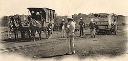
 Unloading the post at the narrow-gauge railway station of Sakaramy, c.a. 1905 | |
| Coordinates: 12°27′S 49°16′E / 12.450°S 49.267°E | |
| Country | |
| Region | Diana |
| District | Antsiranana II |
| Government | |
| • Mayor | Andrianasolo Solofonirina |
| Elevation | 350 m (1,150 ft) |
| Population (2012)[1] | |
| • Total | 3,400 |
| • Ethnicities | Antandroy Tsimihety Antemoro |
| Time zone | UTC3 (EAT) |
| Postal code | 202 |
| Website | Web site Sakaramy |
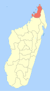
Sakaramy is a rural municipality in Madagascar, 22 km from Antsiranana (Diego Suarez). It belongs to the district of Antsiranana II, which is a part of Diana Region. The population of the municipality was estimated to be approximately 3400 in 2012.
It is situated between Antanamitarana and Joffreville. 5 villages belong to this municipality: Sakaramy centre, Mahatsinjo, Ambdimadiro, Sahasifotra and Ankazomibaboka.
Nature[edit]
The fish Pachypanchax sakaramyi was described from this locality. The Lake Mahery is an interesting site for birdwatching that is found inside the Montagne d'Ambre National Park.[2]
Sports[edit]
- Avenir Sakaramy (football)
History[edit]
Sakaramy was the terminus of the Decauville railway from Diégo Suarez to Sakaramy, which had been built in 1900–1904.
Until 1975 the French Foreign legion had a camp at Sakaramy.
References[edit]


