
Rosport-Mompach
This article needs additional citations for verification. (May 2018) |
Rosport-Mompach
Rouspert-Mompech | |
|---|---|
 The municipal house of Rosport, former home of Henri Tudor | |
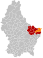
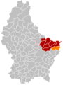
 Map of Luxembourg with Rosport-Mompach highlighted in orange, and the canton in dark red | |
| Coordinates: 49°48′N 6°30′E / 49.8°N 6.5°E | |
| Country | |
| Canton | Echternach |
| Area | |
| • Total | 57.07 km2 (22.03 sq mi) |
| • Rank | 5th of 100 |
| Highest elevation | 399 m (1,309 ft) |
| • Rank | 51st of 100 |
| Lowest elevation | 141 m (463 ft) |
| • Rank | 5th of 100 |
| Population (2023) | |
| • Total | 3,704 |
| • Rank | 45th of 100 |
| • Density | 65/km2 (170/sq mi) |
| • Rank | 28th of 100 |
| Time zone | UTC+1 (CET) |
| • Summer (DST) | UTC+2 (CEST) |
| LAU 2 | LU0001006 |
| Website | www |
Rosport-Mompach (Luxembourgish: Rouspert-Mompech) is a commune of Luxembourg located in the canton of Echternach.
History[edit]
The commune was created on 1 January 2018 with the merging of the communes of Rosport and Mompach.[1]
-
-
-
 Rosport-Mompach


Populated places[edit]
The commune consists of the following villages:
|
|
Population[edit]
Graphs are unavailable due to technical issues. There is more info on Phabricator and on MediaWiki.org. |
Economy[edit]
The commune forms part of the zone d'appellation of Crémant de Luxembourg.
The carbonated water factory Sources Rosport SA is located in Rosport.
The cider company Ramborn Co. is located in Born.
Residents[edit]
- Henri Tudor (1859–1928), engineer
Notes and references[edit]
- ^ Guillaume Chassaing (27 April 2016). "Rosport – Mompach : la fusion " idéale "". www.lequotidien.lu. Retrieved 31 March 2017.
- ^ "Population par canton et commune". statistiques.public.lu. Retrieved 11 January 2022.
Wikimedia Commons has media related to Rosport-Mompach.
Places adjacent to Rosport-Mompach | |
|---|---|
| International | |
|---|---|
| National | |
This Luxembourg location article is a stub. You can help Wikipedia by expanding it. |