
Ranomafana, Ifanadiana
Ranomafana | |
|---|---|
 Ranomafana | |
 Ranomafana Location in Madagascar | |
| Coordinates: 21°15′S 47°27′E / 21.250°S 47.450°E | |
| Country | |
| Region | Vatovavy |
| District | Ifanadiana |
| Area | |
| • Total | 245 km2 (95 sq mi) |
| Elevation | 400 −1,417 m (−4,249 ft) |
| Population (2018) | |
| • Total | 9,705 |
| Time zone | UTC3 (EAT) |
| Postal code | 312 |
Ranomafana is a rural municipality in Madagascar. It belongs to the district of Ifanadiana, which is a part of the region of Vatovavy. The population of the commune was 9,705 in the 2018.
Primary and junior level secondary education are available in the town. 60% of the population of the commune are farmers; the most important crops are bananas and rice, while other important agricultural products are pineapple and cassava. Services provide employment for 40% of the population.[3]
Roads[edit]
The commune is situated at 62 km from Fianarantsoa and 138 km from Mananjary along the National Road 25.
Rivers[edit]
The municipality is crossed by the Namorona River. There are also the Andriamamovoka Falls, a waterfall on the Namorona near the fokontany of Vohiparara.[4]
Sights and Infrastructure[edit]
There is an outdoor swimming pool and bath filled by hot water springs. A well-kept park can be visited close to the outdoor pool. A number of hotels are found throughout the village, accommodating tourist that come to visit the nearby Ranomafana National Park. Ranomafana has a hospital. The Town Hall (Lapan'ny tanana) is on the main road. The Post Office and the Market are at Place de l'Indépendance where a memorial dedicated to the victims of the Malagasy Uprising of 1947 was erected. The Catholic Church was consecrated by bishop François Xavier Tabao Manjarimanana in 1988.[5] The Protestant Church is on a small hill offering a beautiful view of the town centre.
-
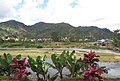 General view of Ranomafana
 -
 Town Hall
 -
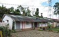
 Hospital
 -
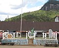 Monument
 -
 Public pool
 -
 Public parc near the hot springs
 -
 Post office
 -
 Catholic church
 -
 Catholic church
 -
 Protestant Church
 -
 Protestant Church
 -
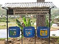 Campaign to keep the town clean


See also[edit]
- Ranomafana National Park at 6.5 km from Ranomafana.
References[edit]
- ^ RAMAMONJISOA, 2014. ARBORETUM COMMUNAL ET INTEGRATION AU DEVELOPPEMENT DURABLE - COMMUNE RURALE DE RANOMAFANA
- ^ Estimated based on DEM data from Shuttle Radar Topography Mission
- ^ "ILO census data". Cornell University. 2002. Retrieved 2008-05-03.
- ^ L'Express.mg: Ranomafana: Un homme glisse dans une cascade
- ^ Commemorative stone at the church, to be seen at Wikipedia Commons
Capital: Mananjary | |
| Ifanadiana (14) -312 | |
| Mananjary (27) - 317 |
|
| Nosy Varika (19) - 319 | |
3 districts; 58 communes | |
21°15′S 47°27′E / 21.250°S 47.450°E
This Vatovavy location article is a stub. You can help Wikipedia by expanding it. |