Pullathomas
Pullathomas
Poll an tSómais Kilcommon / Pollatomais / Pollatomish / Pollathomas | |
|---|---|
Village | |
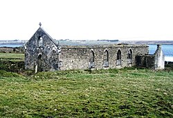
 Ruined church near Pullathomas | |
| Coordinates: 54°14′57″N 9°48′40″W / 54.2491°N 9.81098°W | |
| Country | Ireland |
| Province | Connacht |
| County | County Mayo |
| Area | |
| • Total | (Townland) 2.7745 km2 (685.59 acres) |
| Elevation | 49 m (161 ft) |
| Population | 100 |
| Poll an tSómais is the only official name. The anglicised spelling Pollatomish and English name Pullathomas have no official status. | |
Pullathomas (Irish: Poll an tSómais;[2] also known as Kilcommon, Pollatomais, Pollatomish and Pollathomas) is a Gaeltacht village and townland in northwest County Mayo, Ireland. In the barony of Erris and parish of Kilcommon, it lies close to the mouth of Broadhaven Bay next to Sruwaddacon Bay. Pullathomas townland has an area of approximately 685.6 acres (2.8 km2) and,[3] as of 2011, had a population of 100 people.[1]
History[edit]
The townland is also called Kilcommon after the ancient religious establishment of Saint Coman situated here.[4] Several slayings were recorded by the natives in Pullathomas when the Anglo-Normans came to Ireland.[5]
Peat landslide[edit]
Heavy autumn rainfall in the area of Dooncarton Mountain caused a series of 30 peat landslides between Pullathomas and Glengad on 19 September 2003, causing damages amounting to €620,000.[6] A corner of the old graveyard was struck, sweeping graves into the sea.[7] Several million euros were spent in repairs.[8]
Geography[edit]
Pollatomish Bog NHA[edit]
Pollatomish Bog NHA is a designated area of protected low lying blanket bog about 7 km south of the village. The blanket bog's surface holds moisture and sustains lush growths of bog moss lawns, primarily Sphagnum papillosum and S. capillifolium.[9] Shallow pools dot the landscape, some filling with Bogbean (Menyanthes trifoliata), Lesser Bladderwort (Utricularia minor), Bulbous Rush (Juncus bulbosus), and various bog mosses (Sphagnum spp.). Moving higher up, the peat thins out, transitioning to heath-like vegetation, predominantly Ling Heather.[9]
On the lower northern slopes, degradation due to grazing and erosion is evident, with grasses and sedges dominating the landscape. Species like Cottongrasses, Deergrass, Sweet Vernal-grass (Anthoxanthum odoratum), Green-ribbed Sedge (Carex binervis), Carnation Sedge (Carex panicea), and Heath Bedstraw (Galium saxatile) are among those thriving in this area.[9]
See also[edit]
References[edit]
- ^ a b "CD164 - Mayo Population by Private Households, Occupied and Vacancy Rate". data.gov.ie. Central Statistics Office. Retrieved 31 December 2023.
Population [..] Townlands [..] Kilcommon or Pollatomish, Knocknalower, Co. Mayo [..] 100
- ^ "Poll an tSómais/Pollatomish". logainm.ie (in Irish). Retrieved 2023-12-30.
- ^ "Pollatomish Townland, Co. Mayo". www.townlands.ie. Retrieved 2023-12-30.
- ^ Noone, Fr. Sean (1991). Where The Sun Sets (1st ed.). Ballina: Erris Publications. ISBN 0951817906.
- ^ Knox, Hubert Thomas (1908). History of County Mayo to the close of the 16th century (1st ed.). Dublin: Wentworth Press (published 2019). ISBN 1010933329.
- ^ "Mayo landslides caused by freak weather event". The Irish Times. Retrieved 2023-12-30.
- ^ "Bishop: 'The pain is felt worldwide' as landslides destroy graveyard". Independent.ie. 2003-09-27. Retrieved 2023-12-30.
- ^ Long, Michael; Jennings, Paul (2006-03-01). "Analysis of the peat slide at Pollatomish, County Mayo, Ireland". Landslides. 3 (1): 51–61. doi:10.1007/s10346-005-0006-z. hdl:10197/3098. ISSN 1612-5118.
- ^ a b c "Pollatomish Bog NHA | National Parks & Wildlife Service". www.npws.ie. Retrieved 2023-12-30.


