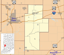
Prairie City, Indiana
Prairie City | |
|---|---|
 | |
| Coordinates: 39°26′44″N 87°06′48″W / 39.44556°N 87.11333°W | |
| Country | United States |
| State | Indiana |
| County | Clay |
| Township | Jackson |
| Elevation | 587 ft (179 m) |
| GNIS feature ID | 441539[1] |
Prairie City is an unincorporated community in Jackson Township, Clay County, Indiana. It is part of the Terre Haute Metropolitan Statistical Area. It is located on State Highway 42. It once included a one room school, a small grocery which was a part of a house on the corner, a garage which did repairs on cars and tractors, and a few houses. The cemetery was across from the school, and both were across Birch Creek. The school was constructed of red brick, common in Clay County. In the 1940s/50s and probably before then the church was an EUB... Evangelical United Brethern.
History[edit]
Prairie City was founded in 1869.[2]
Geography[edit]
Prairie City is located at 39°26′44″N 87°06′48″W / 39.44556°N 87.11333°W.
References[edit]
- ^ "Prairie City, Indiana". Geographic Names Information System. United States Geological Survey, United States Department of the Interior. Retrieved August 20, 2010.
- ^ Baker, Ronald L. (October 1995). From Needmore to Prosperity: Hoosier Place Names in Folklore and History. Indiana University Press. p. 270. ISBN 978-0-253-32866-3.
This village was laid out in 1869...


