The Blue Marble, a photograph of the planet Earth made on 7 December 1972 by the crew of the Apollo 17 spacecraft.
The world is the totality of entities, the whole of reality, or everything that exists. The nature of the world has been conceptualized differently in different fields. Some conceptions see the world as unique while others talk of a "plurality of worlds". Some treat the world as one simple object while others analyze the world as a complex made up of parts.
In scientific cosmology, the world or universe is commonly defined as "[t]he totality of all space and time; all that is, has been, and will be". Theories of modality talk of possible worlds as complete and consistent ways how things could have been. Phenomenology, starting from the horizon of co-given objects present in the periphery of every experience, defines the world as the biggest horizon or the "horizon of all horizons". In philosophy of mind, the world is contrasted with the mind as that which is represented by the mind. Theology conceptualizes the world in relation to God, for example, as God's creation, as identical to God or as the two being interdependent. In religions, there is a tendency to downgrade the material or sensory world in favor of a spiritual world to be sought through religious practice. A comprehensive representation of the world and our place in it, as is found in religions, is known as a worldview. Cosmogony is the field that studies the origin or creation of the world while eschatology refers to the science or doctrine of the last things or of the end of the world.
The World Trade Organization (WTO) is an intergovernmental organization headquartered in Geneva, Switzerland that regulates and facilitates international trade. Governments use the organization to establish, revise, and enforce the rules that govern international trade in cooperation with the United Nations System. The WTO is the world's largest international economic organization, with 164 member states representing over 98% of global trade and global GDP.
The WTO facilitates trade in goods, services and intellectual property among participating countries by providing a framework for negotiating trade agreements, which usually aim to reduce or eliminate tariffs, quotas, and other restrictions; these agreements are signed by representatives of member governments and ratified by their legislatures. It also administers independent dispute resolution for enforcing participants' adherence to trade agreements and resolving trade-related disputes. The organization prohibits discrimination between trading partners, but provides exceptions for environmental protection, national security, and other important goals. (Full article...)
Image 3
A megacity is a very large city, typically with a population of more than 10 million people. The United Nations Department of Economic and Social Affairs in its 2018 "World Urbanization Prospects" report defines megacities as urban agglomerations with over 10 million inhabitants. A University of Bonn report holds that they are "usually defined as metropolitan areas with a total population of 10 million or more people". Elsewhere in other sources, from five to eight million is considered the minimum threshold, alongside a population density of at least 2,000 per square kilometre. The terms conurbation, metropolis, and metroplex are also applied to the latter.
The total number of megacities in the world varies between different sources: The world had 33 according to the UN (in 2018), 45 according to CityPopulation.de (in 2023), and 44 according to Demographia (in 2023). About half of these urban agglomerations are in China and India. The other four countries with more than one megacity are Brazil, Japan, Pakistan, and the United States. African megacities are present in Nigeria, Egypt, South Africa, and the DRC; European megacities are present in Russia, France, the United Kingdom, and Turkey (also in Asia); megacities can be found in Latin America in the countries of Brazil, Mexico, Colombia, Peru, and Argentina. Some sources identify Tokyo's Greater Tokyo Area as the largest megacity in the world, while some others give the title to the Pearl River Delta in China. (Full article...)
Image 4
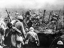
World War I or the First World War (28 July 1914 – 11 November 1918) was a global conflict between two coalitions: the Allies and the Central Powers. Fighting took place throughout Europe, the Middle East, Africa, the Pacific, and parts of Asia. One of the deadliest wars in history, it resulted in an estimated 9 million soldiers dead and 23 million wounded, plus up to 8 million civilian deaths from numerous causes including genocide. The movement of large numbers of troops and civilians during the war was a major factor in spreading the 1918 Spanish flu pandemic.
GCOS is a system that comprises the climate-relevant components of many contributing observing systems and networks. Its mission is to help ensure that these contributing systems, taken as a whole, provide the comprehensive information on the global climate system that is required by users, including individuals, national and international organizations, institutions and agencies. The programme promotes the sustained provision and availability of reliable physical, chemical and biological observations and data records for the total climate system - across the atmospheric, oceanic and terrestrial domains, including the hydrological cycle, the carbon cycle and the cryosphere. (Full article...)
Image 6
Medical professionals treating a COVID-19 patient in critical condition in an intensive care unit in São Paulo in May 2020
The following are images from various world-related articles on Wikipedia.
Image 1A 2012 artistic impression of the early Solar System's protoplanetary disk from which Earth and other Solar System bodies were formed (from Earth)
Image 2A reconstruction of Pannotia (550 Ma). (from History of Earth)
Image 3A schematic view of Earth's magnetosphere with solar wind flowing from left to right (from Earth)
Image 17Artist's impression of a Hadean landscape with the relatively newly formed Moon still looming closely over Earth and both bodies sustaining strong volcanism. (from History of Earth)
Image 19Trilobites first appeared during the Cambrian period and were among the most widespread and diverse groups of Paleozoic organisms. (from History of Earth)
Image 20Japanese depiction of a Portuguese carrack. European maritime innovations led to proto-globalization.
Image 21Shanghai. China urbanized rapidly in the 21st century.
Image 22First airplane, the Wright Flyer, flew on 17 December 1903.
Image 24Earth's western hemisphere showing topography relative to Earth's center instead of to mean sea level, as in common topographic maps (from Earth)
Image 25Angkor Wat temple complex, Cambodia, early 12th century
Image 26An artist's impression of ice age Earth at glacial maximum. (from History of Earth)
Image 29Pangaea was a supercontinent that existed from about 300 to 180 Ma. The outlines of the modern continents and other landmasses are indicated on this map. (from History of Earth)
Image 31The replicator in virtually all known life is deoxyribonucleic acid. DNA is far more complex than the original replicator and its replication systems are highly elaborate. (from History of Earth)
Image 33Artist's rendition of an oxinated fully-frozen Snowball Earth with no remaining liquid surface water. (from History of Earth)
Image 34Conjectured illustration of the scorched Earth after the Sun has entered the red giant phase, about 5–7 billion years from now (from Earth)
Image 35A map of heat flow from Earth's interior to the surface of Earth's crust, mostly along the oceanic ridges (from Earth)
Image 36Tiktaalik, a fish with limb-like fins and a predecessor of tetrapods. Reconstruction from fossils about 375 million years old. (from History of Earth)
Image 46Change in average surface air temperature and drivers for that change. Human activity has caused increased temperatures, with natural forces adding some variability. (from Earth)
Image 51Artist's impression of Earth during the later Archean, the largely cooled planetary crust and water-rich barren surface, marked by volcanoes and continents, features already roundmicrobialites. The Moon, still orbiting Earth much closer than today and still dominating Earth's sky, produced strong tides. (from History of Earth)
Image 52An artist's impression of the Archean, the eon after Earth's formation, featuring round stromatolites, which are early oxygen-producing forms of life from billions of years ago. After the Late Heavy Bombardment, Earth's crust had cooled, its water-rich barren surface is marked by continents and volcanoes, with the Moon still orbiting Earth half as far as it is today, appearing 2.8 times larger and producing strong tides. (from Earth)
Image 56Map of peopling of the world (Southern Dispersal paradigm), in thousands of years ago.
Image 57An animation of the changing density of productive vegetation on land (low in brown; heavy in dark green) and phytoplankton at the ocean surface (low in purple; high in yellow) (from Earth)
Image 58Empires of the world in 1898
Image 59A view of Earth with its global ocean and cloud cover, which dominate Earth's surface and hydrosphere; at Earth's polar regions, its hydrosphere forms larger areas of ice cover. (from Earth)
Image 76Earth's night-side upper atmosphere appearing from the bottom as bands of afterglow illuminating the troposphere in orange with silhouettes of clouds, and the stratosphere in white and blue. Next the mesosphere (pink area) extends to the orange and faintly green line of the lowest airglow, at about one hundred kilometers at the edge of space and the lower edge of the thermosphere (invisible). Continuing with green and red bands of aurorae stretching over several hundred kilometers. (from Earth)
Image 84Geologic map of North America, color-coded by age. From most recent to oldest, age is indicated by yellow, green, blue, and red. The reds and pinks indicate rock from the Archean.
Image 85Exaggerated illustration of Earth's elliptical orbit around the Sun, marking that the orbital extreme points (apoapsis and periapsis) are not the same as the four seasonal extreme points, the equinox and solstice (from Earth)
Image 86Chloroplasts in the cells of a moss (from History of Earth)
The City of Paris is the centre of the Île-de-Franceregion, or Paris Region, with an official estimated population of 12,271,794 inhabitants on 1 January 2023, or about 19% of the population of France. The Paris Region had a GDP of €765 billion (US$1.064 trillion, PPP) in 2021, the highest in the European Union. According to the Economist Intelligence Unit Worldwide Cost of Living Survey, in 2022, Paris was the city with the ninth-highest cost of living in the world. (Full article...)
The Seven Wonders of Colombia (Spanish: Siete maravillas de Colombia) was a 2007 competition sponsored by El Tiempo. The newspaper asked readers to nominate and vote for man-made structures whose engineering, architectural or historical value deserved special recognition. (Full article...)
There are four categories of protected areas in India, constituted under the Wildlife Protection Act, 1972. Tiger reserves consist of areas under national parks and wildlife sanctuaries. There are 53 tiger reserves in India. the protected areas of India cover 173,629.52 square kilometres (67,038.73 sq mi), roughly 5.28% of the total geographical area of the country. (Full article...)
This is a list of the nationally designated protected areas of China. There are many forms of protected areas in China. Based on their relative importance, each type of protected area can be further graded into two to three levels (national, provincial and prefectural/county level). Nevertheless, the highest rank for "pocket nature preserve" (social and mass-based), "no-hunting area", "no-fishing area", "no-logging area", "wild medicinal material resources conservation area", "crop germplasm resources conservation area", "forest tree germplasm resources conservation area" or "source water protection area" is practically restricted to provincial level. The local government at county level is also responsible for the delimitation and declaration of "basic farmland protection area" and "basic grassland".
Take note that many protected areas in China have multiple official designations, and the statutory boundaries of these multi-designated PAs may be identical or may vary one from the other. For instance, the boundaries of Huangshan NSHA coincide with those of the Huangshan NGP, whereas Fujian province's Wuyi Mountains NNR, NSHA and NFP are adjacent to each other. In Heilongjiang, 27,642.14 hectares out of 115,340.27 hectares of Huzhong NFP are intersected with the experiment zone of Huzhong NNR. (Full article...)
Estonia has five national parks, 167 nature reserves and 152 landscape conservation areas. In addition, there are 116 (118) protected areas with an old (Soviet-era) protection regulation and 537 parks. In total, 18.1% of Estonia are protected nature areas, with Lääne County having the highest percentage (32%) and Põlva County the lowest percentage of protected areas, about 9%. (Full article...)
Meanwhile, the central government has proclaimed the Coastline and the Tirana Greenbelt as areas of national importance. (Full article...)
Image 8
Redwood grove in Redwood National Park According to the California Protected Areas Database (CPAD), in the state of California, United States, there are over 14,000 inventoried protected areas administered by public agencies and non-profits. In addition, there are private conservation areas and other easements. They include almost one-third of California's scenic coastline, including coastal wetlands, estuaries, beaches, and dune systems. The California State Parks system alone has 270 units and covers 1.3 million acres (5,300 km2), with over 280 miles (450 km) of coastline, 625 miles (1,006 km) of lake and river frontage, nearly 18,000 campsites, and 3,000 miles (5,000 km) of hiking, biking, and equestrian trails.
Obtaining an accurate total of all protected land in California and elsewhere is a complex task. Many parcels have inholdings, private lands within the protected areas, which may or may not be accounted for when calculating total area. Also, occasionally one parcel of land is included in two or more inventories. Over 90% of Yosemite National Park for example, is listed both as wilderness by the National Wilderness Preservation System, and as national park land by the National Park Service. The Cosumnes River Preserve is an extreme example, owned and managed by a handful of public agencies and private landowners, including the Bureau of Land Management, the County of Sacramento and The Nature Conservancy. Despite the difficulties, the CPAD gives the total area of protected land at 49,294,000 acres (199,490 km2), or 47.05% of the state (not including easements); a considerable amount for the most populous state in the country. (Full article...)
The supreme responsibility for conservation lies with the Norwegian Ministry of the Environment, which has delegated the management to the Governor of Svalbard and the Norwegian Directorate for Nature Management. The foundation for conservation was established in the Svalbard Treaty of 1920, and has been further specified in the Svalbard Environmental Act of 2001. The first round of protection took force on 1 July 1973, when most of the current protected areas came into effect. This included the two large nature reserves and three of the national parks. Moffen Nature Reserve was established in 1983, followed by four national parks, three nature reserves and one geotope protection area between 2002 and 2005. (Full article...)
As of 2022, based on the latest Collaborative Australian Protected Areas Database report, it contains 1857 separate land-based protected areas with a total area of 76,142,710 hectares (188,152,700 acres), accounting for just over 30 percent of the state's land mass. By area, Indigenous Protected Areas account for the largest part of this, almost 67 percent while, by number, nature reserves hold the majority with two-third of all land-based protected areas being nature reserves. (Full article...)
The headquarters of the National Parks Service are in downtown Buenos Aires, on Santa Fe Avenue. A library and information centre are open to the public. The administration also covers the national monuments, such as the Jaramillo Petrified Forest, and natural and educational reserves. (Full article...)
This is a list of protected areas of Yukon. The Yukon, formerly called Yukon Territory and sometimes referred to as just Yukon is the smallest and westernmost of Canada's three territories. It also is the least populated province or territory in Canada, with a population of 35,874 people as of the 2016 Census. (Full article...)
Image 8Only a few of the largest large igneous provinces appear (coloured dark purple) on this geological map, which depicts crustal geologic provinces as seen in seismic refraction data


 A sovereign state is a state that has the highest authority over a territory.

.svg)


 A 2012 artistic impression of the early Solar System's protoplanetary disk from which Earth and other Solar System bodies were formed (from Earth)
 A reconstruction of Pannotia (550 Ma). (from History of Earth)
 A schematic view of Earth's magnetosphere with solar wind flowing from left to right (from Earth)
 A pillar at Göbekli Tepe
 Artist's impression of the enormous collision that probably formed the Moon (from History of Earth)
 A computer-generated image mapping the prevalence of artificial satellites and space debris around Earth in geosynchronous and low Earth orbit (from Earth)
 Cross-section through a liposome (from History of Earth)
 A Benin Bronze head from Nigeria

 Vitruvian Man by Leonardo da Vinci epitomizes the advances in art and science seen during the Renaissance. (from History of Earth)
 A banded iron formation from the 3.15 Ga Moodies Group, Barberton Greenstone Belt, South Africa. Red layers represent the times when oxygen was available; gray layers were formed in anoxic circumstances. (from History of Earth)
 Graph showing range of estimated partial pressure of atmospheric oxygen through geologic time (from History of Earth)
 Ming dynasty section, Great Wall of China
 Artist's impression of a Hadean landscape with the relatively newly formed Moon still looming closely over Earth and both bodies sustaining strong volcanism. (from History of Earth)
 Chennakesava Temple, Belur, India
 Trilobites first appeared during the Cambrian period and were among the most widespread and diverse groups of Paleozoic organisms. (from History of Earth)
 Japanese depiction of a Portuguese carrack. European maritime innovations led to proto-globalization.
 Shanghai. China urbanized rapidly in the 21st century.
 First airplane, the Wright Flyer, flew on 17 December 1903.
 Battle during 1281 Mongol invasion of Japan
 Earth's western hemisphere showing topography relative to Earth's center instead of to mean sea level, as in common topographic maps (from Earth)
 Angkor Wat temple complex, Cambodia, early 12th century
 An artist's impression of ice age Earth at glacial maximum. (from History of Earth)
 A 580 million year old fossil of Spriggina floundensi, an animal from the Ediacaran period. Such life forms could have been ancestors to the many new forms that originated in the Cambrian Explosion. (from History of Earth)
 Pangaea was a supercontinent that existed from about 300 to 180 Ma. The outlines of the modern continents and other landmasses are indicated on this map. (from History of Earth)
 The replicator in virtually all known life is deoxyribonucleic acid. DNA is far more complex than the original replicator and its replication systems are highly elaborate. (from History of Earth)
 Last Moon landing: Apollo 17 (1972)
 Artist's rendition of an oxinated fully-frozen Snowball Earth with no remaining liquid surface water. (from History of Earth)
 A map of heat flow from Earth's interior to the surface of Earth's crust, mostly along the oceanic ridges (from Earth)
 Tiktaalik, a fish with limb-like fins and a predecessor of tetrapods. Reconstruction from fossils about 375 million years old. (from History of Earth)
 Ajloun Castle, Jordan
 Great Mosque of Kairouan, Tunisia, founded 670 CE
 Pale orange dot, an artist's impression of Early Earth, featuring its tinted orange methane-rich early atmosphere (from Earth)
 Earth's axial tilt causing different angles of seasonal illumination at different orbital positions around the Sun (from Earth)
 Fall of the Berlin Wall, 1989
 "Lucy", the first Australopithecus afarensis skeleton found. Lucy was only 1.06 m (3 ft 6 in) tall.
 Change in average surface air temperature and drivers for that change. Human activity has caused increased temperatures, with natural forces adding some variability. (from Earth)
 Florence, birthplace of the Italian Renaissance
 Image of the physical world, captured by the Hubble Space Telescope (from World)
 A view of Earth with different layers of its atmosphere visible: the troposphere with its clouds casting shadows, a band of stratospheric blue sky at the horizon, and a line of green airglow of the lower thermosphere around an altitude of 100 km, at the edge of space (from Earth)
 Artist's impression of Earth during the later Archean, the largely cooled planetary crust and water-rich barren surface, marked by volcanoes and continents, features already round microbialites. The Moon, still orbiting Earth much closer than today and still dominating Earth's sky, produced strong tides. (from History of Earth)
 Notre-Dame de Paris, France

 Map of peopling of the world (Southern Dispersal paradigm), in thousands of years ago.
 An animation of the changing density of productive vegetation on land (low in brown; heavy in dark green) and phytoplankton at the ocean surface (low in purple; high in yellow) (from Earth)
 Empires of the world in 1898
 A view of Earth with its global ocean and cloud cover, which dominate Earth's surface and hydrosphere; at Earth's polar regions, its hydrosphere forms larger areas of ice cover. (from Earth)
 Tracy Caldwell Dyson, a NASA astronaut, observing Earth from the Cupola module at the International Space Station on 11 September 2010 (from Earth)
 Standing Buddha from Gandhara, 2nd century CE
 Dinosaurs were the dominant terrestrial vertebrates throughout most of the Mesozoic (from History of Earth)
 Machu Picchu, Inca Empire, Peru
 Olmec colossal head, now at the Museo de Antropología de Xalapa
 Great Pyramids of Giza, Egypt
 A composite image of artificial light emissions at night on a map of Earth (from Earth)
 An artist's rendering of a protoplanetary disk (from History of Earth)
 View of Earth from the Moon by the Lunar Reconnaissance Orbiter (from Earth)
 Lithified stromatolites on the shores of Lake Thetis, Western Australia. Archean stromatolites are the first direct fossil traces of life on Earth. (from History of Earth)
 Artist's conception of Devonian flora (from History of Earth)
 Artist's conception of Hadean Eon Earth, when it was much hotter and inhospitable to all forms of life. (from History of Earth)
 Obelisk of Axum, Ethiopia
 Earth's night-side upper atmosphere appearing from the bottom as bands of afterglow illuminating the troposphere in orange with silhouettes of clouds, and the stratosphere in white and blue. Next the mesosphere (pink area) extends to the orange and faintly green line of the lowest airglow, at about one hundred kilometers at the edge of space and the lower edge of the thermosphere (invisible). Continuing with green and red bands of aurorae stretching over several hundred kilometers. (from Earth)
 Taj Mahal, Mughal Empire, India
 Earth's history with time-spans of the eons to scale (from History of Earth)
 A reconstruction of human history based on fossil data. (from History of Earth)
 Persepolis, Achaemenid Empire, 6th century BCE
 Yggdrasil, an attempt to reconstruct the Norse world tree which connects the heavens, the world, and the underworld. (from World)
 Geologic map of North America, color-coded by age. From most recent to oldest, age is indicated by yellow, green, blue, and red. The reds and pinks indicate rock from the Archean.
 Chloroplasts in the cells of a moss (from History of Earth)
 Satellite time lapse imagery of Earth's rotation showing axis tilt (from Earth)
 The Pantheon, originally a Roman temple, now a Catholic church
 Earth's land use for human agriculture in 2019 (from Earth)
 A composite image of Earth, with its different types of surface discernible: Earth's surface dominating Ocean (blue), Africa with lush (green) to dry (brown) land and Earth's polar ice in the form of Antarctic sea ice (grey) covering the Antarctic or Southern Ocean and the Antarctic ice sheet (white) covering Antarctica. (from Earth)


.jpg)


.jpg)


.svg)


.jpeg)


.jpg)


.jpg)


.jpg)

.svg)


 Time zones of the world
 United Nations Human Development Index map by country (2016)
 Index map from the International Map of the World (1:1,000,000 scale)
 A plate tectonics map with volcano locations indicated with red circles
 Mollweide projection of the world
 The world map by Gerardus Mercator (1569), the first map in the well-known Mercator projection
 The Goode homolosine projection is a pseudocylindrical, equal-area, composite map projection used for world maps.
 Only a few of the largest large igneous provinces appear (coloured dark purple) on this geological map, which depicts crustal geologic provinces as seen in seismic refraction data
 1516 map of the world by Martin Waldseemüller


 Commons
 Wikibooks
 Wikidata
 Wikinews
 Wikiquote
 Wikisource
 Wikispecies
 Wikiversity
 Wikivoyage
 Wiktionary


