
Palota
Palota | |
|---|---|
Municipality | |
 | |
 Palota Location of Palota in the Prešov Region  Palota Location of Palota in Slovakia | |
| Coordinates: 49°16′N 22°00′E / 49.267°N 22.000°E | |
| Country | |
| Region | Prešov |
| District | Medzilaborce |
| First mentioned | 1330 |
| Area | |
| • Total | 24.11[2] km2 (9.31[2] sq mi) |
| Elevation | 439[3] m (1,440[3] ft) |
| Population (2021) | |
| • Total | 188[1] |
| Time zone | UTC+1 (CET) |
| • Summer (DST) | UTC+2 (CEST) |
| Postal code | 067 51[3] |
| Area code | +421 57[3] |
| Car plate | ML |
| Website | www |
Palota (Rusyn: Палота) is a village and municipality in the Medzilaborce District in the Prešov Region of far north-eastern Slovakia.
History[edit]
In historical records the village was first mentioned in 1330.
Geography[edit]
The municipality lies at an altitude of 482 metres (1,581 feet) and covers an area of 24.116 square kilometres (9.311 square miles). It has a population of about 190 people.
Gallery[edit]
-
 Orthodox Church of the Nativity of Our Lady in Palota
 -
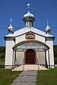 Front facade of the Orthodox Church of the Nativity of Our Lady in Palota
 -
 Orthodox Church of the Nativity of Our Lady and belfry in Palota
 -
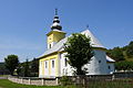 Greek Catholic Church in Palota
 -
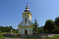
 Greek Catholic Church in Palota
 -
 Front facade of Greek Catholic Church in Palota
 -
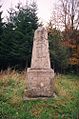
 WWI military cemetery in Palota
 -
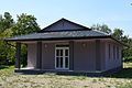 Funeral home in Palota
 -
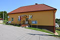 Municipal office in Palota
 -
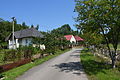
 A street with newer housing in Palota
 -
 Street with local stream in Palota
 -
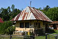 Old cottage in Palota
 -
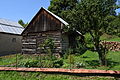 Traditional wooden barn in Palota
 -
 Commemorative plaque and T-34 medium tank on public display at local WWII memorial
 -
 The Palota-Radoszyce foot-only border crossing between Poland and Slovakia
 -
 1890s boundary stone at the Palota-Radoszyce foot-only border crossing between Poland and Slovakia


References[edit]
- ^ "Počet obyvateľov podľa pohlavia - obce (ročne)". www.statistics.sk (in Slovak). Statistical Office of the Slovak Republic. 2022-03-31. Retrieved 2022-03-31.
- ^ a b "Hustota obyvateľstva - obce [om7014rr_ukaz: Rozloha (Štvorcový meter)]". www.statistics.sk (in Slovak). Statistical Office of the Slovak Republic. 2022-03-31. Retrieved 2022-03-31.
- ^ a b c d "Základná charakteristika". www.statistics.sk (in Slovak). Statistical Office of the Slovak Republic. 2015-04-17. Retrieved 2022-03-31.
- ^ a b "Hustota obyvateľstva - obce". www.statistics.sk (in Slovak). Statistical Office of the Slovak Republic. 2022-03-31. Retrieved 2022-03-31.
External links[edit]
 Media related to Palota at Wikimedia Commons
- Official website

- http://www.statistics.sk/mosmis/eng/run.html
Municipalities of Medzilaborce District | ||
|---|---|---|
This Prešov Region geography article is a stub. You can help Wikipedia by expanding it. |