Nadowli-Kaleo District
Nadowli-Kaleo District | |
|---|---|
 Districts of Upper West Region | |
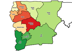
Location of Nadowli-Kaleo District within Upper West | |
| Coordinates: 10°22′26″N 2°40′26″W / 10.37389°N 2.67389°W | |
| Country | |
| Region | Upper West |
| Capital | Nadowli |
| Area | |
| • Total | 2,594 km2 (1,002 sq mi) |
| Population (2021) | |
| • Total | 77,057[1] |
| Time zone | UTC+0 (GMT) |
| ISO 3166 code | GH-UW-NK |
Nadowli-Kaleo District is one of the eleven districts in Upper West Region, Ghana.[2][3][4][5] Originally it was formerly part of the then-larger Nadowli District in 1988; until the eastern part of the district were later split off to create Daffiama-Bussie-Issa District on 28 June 2012; thus the remaining part has been renamed as Nadowli-Kaleo District. The district assembly is located in the northeast part of Upper West Region and has Nadowli as its capital town.
Economy[edit]
Agriculture is the most important economic sector of Nadowli District, accounting for about 85% of the labor force. The commercial and industrial sectors are less developed.
References[edit]
- ^ Ghana: Administrative Division
- ^ "New Districts & Nominated DCEs" (PDF). ghanadistricts. Archived from the original (PDF) on 5 March 2013.
- ^ "All Districts". ghanadistricts. Retrieved 8 June 2018.
- ^ "Districts of Ghana". statoids. Retrieved 8 June 2018.
- ^ "Work to start on 670-km feeder roads in Upper West". Graphic Online. Retrieved 2021-05-22.


