
Mayo-Tsanaga
Mayo-Tsanaga | |
|---|---|
 Department location in Cameroon | |
| Country | |
| Province | Extreme-Nord Province |
| Capital | Mokolo |
| Area | |
| • Total | 1,696 sq mi (4,393 km2) |
| Population (2005) | |
| • Total | 699,971 |
| Time zone | UTC+1 (WAT) |
Mayo-Tsanaga is a department of Extreme-Nord Province in Cameroon. The department covers an area of 4,393 km2 and at the 2005 Census had a total population of 699,971.[1] The capital of the department is at Mokolo. It is located within the Mandara Mountains, on the border with Nigeria.
Subdivisions[edit]
The department is divided administratively into 7 communes and in turn into villages.
Communes[edit]
Gallery[edit]
-
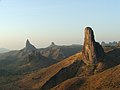 Mandara Mountains
 -
 Mandara Mountains
 -
 Mandara Mountains
.jpg)
.jpg)

References[edit]
- ^ "Departments of Cameroon". Statoids, obtained from Institut national de la statistique (Cameroun) - Annuaire statistique du Cameroun 2004. Retrieved April 27, 2009.

10°44′24″N 13°48′10″E / 10.74000°N 13.80278°E
This Cameroon location article is a stub. You can help Wikipedia by expanding it. |