
Matukutūreia
| Matukutūreia | |
|---|---|
| McLaughlins Mountain | |
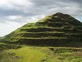
 The eastern side of Matukutūreia, with the (now removed) water tank on the summit. | |
| Highest point | |
| Elevation | 73 m (240 ft) |
| Prominence | 71 to 73 m (233 to 240 ft) |
| Coordinates | 37°00′49″S 174°50′46″E / 37.013511°S 174.845974°E |
| Geography | |
| Location | North Island, New Zealand |
| Geology | |
| Age of rock | 48,000 ± 3000 years[1]: 12 |
| Volcanic arc/belt | Auckland volcanic field |
| Last eruption | 48,000 years[1]: 12 |
Matukutūreia (also McLaughlins Mountain) is one of the volcanic cones in the Auckland volcanic field. It has a peak 73 metres above sea level, and was the site of a pā. The scoria cone was originally crescent-shaped and featured Māori terraces and kumara pits, before extensive quarrying reduced it to a pyramid-shaped mound big enough to support the summit water tank for Papatoetoe. A small part of the summit and the eastern side of the cone were left unquarried, plus a large area of lava flows to the south of the cone remains intact. These remaining parts have recently been transferred to Department of Conservation Management, primarily because of the high heritage values of the Matukuturua Stonefields gardens.
Matukutūreia and nearby Wiri Mountain are collectively known as Matukurua (also Ngā Matukurua).[2]
From July to September 2010, the water tank was removed from the top of Matukutūreia, as part of an agreement when the land was handed over to the Department of Conservation.
Geology[edit]
Matukutūreia is a spatter cone associated with the Matukuturua lava field,[1]: 15 and has geophysical features that raised the possibility of it being a rootless cone, with no apparent gravitational or magnetic evidence of a residual lava conduit but a uniform best-fit magnetic declination of about 20° west implying a short eruption.[3] Rootless cones can form when a lava flow flows over a localised water accumulation but the surface of the lava flow solidifies allowing continuing explosive tephra eruptions from the interactions of heat, lava and steam to form a cone.[4] Later work by the same group clarified that Matukutūreia itself had a 140 nT peak to peak magnetic anomaly, but four eruption craters to its west and south-west towards the Puhinui Reserve are not associated with any magnetic anomaly.[5] One of these the Matukuturua explosion crater is within the Matukuturua lava field and only 500 m (1,600 ft) from Matukutūreia was definitely formed by a single steam event.[1]: 15 This is consistent with the observations elsewhere on the mechanism of rootless cone formation but also in the case of the explosion crater a phreatic eruption scenario where magma never reaches the surface.[1]: 15 The three Puhinui Craters are maar structures and also could have the same origin but this is not known to be the case. The source of the Matukuturua lava is assigned to the extensively quarried Matukutūreia, which therefore has a root, and the Matukuturua crater has been incorporated in the reserve area as a result of these unusual properties for an Auckland volcanic field crater.[1]: 22
-
 The water tank partly removed.
 -
 A crane finishing up with the removal.
 -
 Matukutūreia in its current state.


References[edit]
- ^ a b c d e f Cronin, S. (2019). Technical Report 6:Geological evaluation Mclaughins Quarry private plan change request Geological evaluation of outstanding natural feature: Matukutūreia and Matukuturua lava field and tuff ring (PDF) (Report). pp. 1–23. Archived from the original (PDF) on 10 February 2024. Retrieved 10 February 2024.
- ^ Manurewa Marae Website "A Tale of Manurewa" Archived 2010-06-02 at the Wayback Machine
- ^ Rout, D.J.; Cassidy, J.; Locke, C.A.; Smith, I.E. (1993). "Geophysical evidence for temporal and structural relationships within the monogenetic basalt volcanoes of the Auckland volcanic field, northern New Zealand". Journal of Volcanology and Geothermal Research. 57 (1–2): 71–83. Bibcode:1993JVGR...57...71R. doi:10.1016/0377-0273(93)90032-M.
- ^ Burr, Devon M.; Bruno, Barbara C.; Lanagan, Peter D.; Glaze, Lori S.; Jaeger, Windy L.; Soare, Richard J.; Wan Bun Tseung, Jean-Michel; Skinner, James A.; Baloga, Stephen M. (2009). "Mesoscale raised rim depressions (MRRDs) on Earth: A review of the characteristics, processes, and spatial distributions of analogs for Mars". Planetary and Space Science. 57 (5–6): 579–596. Bibcode:2009P&SS...57..579B. doi:10.1016/j.pss.2008.11.011.
- ^ Cassidy, J.; Locke, C.A.; Miller, C.A.; Rout, D.J. (1999). "The Auckland volcanic field, New Zealand: geophysical evidence for its eruption history". Geological Society, London, Special Publications. 161 (1): 1–10. Bibcode:1999GSLSP.161....1C. doi:10.1144/GSL.SP.1999.161.01.02.
Sources[edit]
- City of Volcanoes: A geology of Auckland - Searle, Ernest J.; revised by Mayhill, R.D.; Longman Paul, 1981. First published 1964. ISBN 0-582-71784-1.
- Volcanoes of Auckland: The Essential Guide - Hayward, B.W., Murdoch, G., Maitland, G.; Auckland University Press, 2011.
- Volcanoes of Auckland: A Field Guide. Hayward, B.W.; Auckland University Press, 2019, 335 pp. ISBN 0-582-71784-1.
External links[edit]
- Early photo of Matukutūreia showing its pre-quarried shape and Maori earthworks
- Photographs of Matukutūreia held in Auckland Libraries' heritage collections.
