
Lunugala
Lunugala
ලුණුගල லுணுகலை | |
|---|---|
.jpg) The Madolsima region of Lunugala | |
| Coordinates: 7°2′0″N 81°12′0″E / 7.03333°N 81.20000°E | |
| Country | Sri Lanka |
| Province | Uva |
| District | Badulla |
| Government | |
| • Pradeshiya Saba | Lunugala Pradeshiya Sabava |
| • Pradesiya Sabapathi | no |
| Population | |
| • Total | 41,159[Census of population Housing SL2,011] |
| Time zone | UTC+05:30 (Sri Lanka Standard Time Zone) |
| Social Network Profile,[1][2] | |
Lunugala is a town in the Sri Lankan province of Uva.There are 28 Grama Niladhari Divisions in the Lunugala Divisional Secretariat Division[3][4]
The town is placed in middle of a mountain range. It was called "Pattipola" (පට්ටිපොල) in the past. Its main agricultural product is tea. There are many beautiful tea estates in Lunugala as Adawatta Estate, Park Estate, Hopton Estate, Showlands Estate and Madolsima Plantation. Additionally people cultivate pepper, cinnamon and cacao.
.JPG)
Society & Population Distribution[edit]
Basically the society of lunugala consists of three major types—Sinhala, Tamil and Muslims. These people live peacefully together. In some places there are cross marriages as Tamil-Muslims, Muslim-Sinhala and Tamil-Sinhala.
-
 Lunugala population by religion According to Census of Population Housing SL,2011
 -
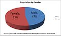 Lunugala population by gender, According to Census of Population Housing SL,2011
 -
 Lunugala population classification by Age differences, According to Census of population Housing SL,2011


Schools[edit]
- Lunugala Central College[5]
- Yapamma Sri Dhammananda Vidyalaya
- Rama Krishna College
- kalai mahal tamil maha vidyalayam
- Muslim School
- Jayabima Primary school
Religious places[edit]
- Lunugala Sri Lonagiri Purana Rajamaha Viharaya
- Yapamma Sri Ramya Vijayarama Viharaya
- Lunugala Sri Kadireshan Kovil
- Lunugala Jumma Mosque
- Lunugala Catholic Church
Hospitals[edit]
- Lunugala Hospital
- hopton Hospital
- Adawatta Dispensary
Public banks[edit]
- Bank of Ceylon
- Peoples Bank
- Regional Development Bank
Gallery[edit]
-
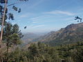
 Beauty of Lunugala 1
 -
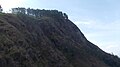
 Beauty of Lunugala 2
 -
 Beauty of Lunugala 3
 -
 Beauty of Lunugala 4
 -
 Beauty of Lunugala 5
.JPG)
.JPG)
.JPG)
.jpg)
.jpg)
References[edit]
- Madulsima, a top tourist attraction [1] by M.H.M.N. Bandara
7°02′N 81°12′E / 7.033°N 81.200°E
This Uva Province, Sri Lanka location article is a stub. You can help Wikipedia by expanding it. |