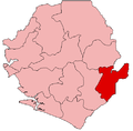
Kissi Teng Chiefdom
Kissi Teng Chiefdom | |
|---|---|
| Coordinates: 8°25′00″N 10°20′00″W / 8.41667°N 10.33333°W | |
| Country | |
| Province | Eastern Province |
| District | Kailahun District |
| Capital | Kangama |
| Population (2004[1]) | |
| • Total | 30,455 |
| Time zone | UTC+0 (GMT) |
Kissi Teng Chiefdom is a chiefdom in Kailahun District of Sierra Leone with a population of 30,455.[1] Its largest town is Koindu, but its headquarters is in Kangama. The major industry in Kissi Teng Chiefdom is farming. The population of Kissi Teng Chiefdom is largely from the Kissi ethnic group[1].
During the Sierra Leone Civil War the Kissi Teng Chiefdom was one of the major strongholds of the Revolutionary United Front (RUF). The RUF maintained a base in Koindu[2] and a significant presence in Kangama.[3] Kissi Teng was one of the last chiefdoms to be disarmed in January 2002 at the end of the civil war.[4]
The dispute with Guinea over their soldiers remaining within Sierra Leone ten years after the end of the civil war centers around Yenga in Kissi Teng.[5]
Notes[edit]
- ^ a b "Final Results 2004 Population and Housing Census" (pdf). Government of Sierra Leone. 2006. p. 6. Retrieved 26 February 2011.
- ^ Centre for Documentation and Research, United Nations High Commissioner for Refugees (November 1998). UNHCR Background Paper on Refugees and Asylum Seekers from Sierra Leone (PDF). Geneva, Switzerland: United Nations High Commissioner for Refugees (UNHCR). p. 9. alternate source
- ^ Smith, L. Alison; Gambette, Catherine; Longley, Thomas (10 March 2004). Conflict Mapping in Sierra Leone: Violations of Humanitarian Law from 1991 to 2002 (PDF). Freetown, Sierra Leone: No Peace Without Justice. pp. 257–279.
- ^ Smith, Gambette & Longley 2004, p. 287
- ^ "Guinea-Sierra Leone 'deal' to end Yenga dispute". BBC News. 2 August 2012.

