
Jaura, Madhya Pradesh
Jaura | |
|---|---|
jel mai | |
 | |
| Nickname: City of Guava | |
 Jaura Location in Madhya Pradesh, India  Jaura Jaura (India) | |
| Coordinates: 26°20′40″N 77°48′41″E / 26.34444°N 77.81139°E | |
| Country | |
| State | Madhya Pradesh |
| District | Morena |
| Population (2001) | |
| • Total | 25,514 |
| Languages | |
| • Official | Hindi |
| Time zone | UTC+5:30 (IST) |
Jaura (also spelt Joura or Jora) is a town and a nagar palika in Morena district in the Indian state of Madhya Pradesh.
Jaura is part of Morena Lok Sabha constituency along with seven other Vidhan Sabha segments, namely, Sabalgarh, Sumawali, Morena, Dimani and Ambah in this district and Sheopur and Vjaypur in Sheopur district.
Jaura is also a railway station on the Gwalior Light Railway, a narrow-gauge line from Gwalior to Sheopur.
Demographics[edit]
[needs update] As of the 2011 Census of India,[1] Joura had a population of 398,111. Males constitute 54% of the population and females 46%. Joura has an average literacy rate of 55.8% (as per 2001 census, it was 64%), less than the national average of 74%: male literacy is 66%, and female literacy is 42.6%. In Joura, 16% of the population is under 6 years of age.
Among the villages that pertain to the tehsil of Jaura is gram panchayat Chachiha.[2]
Gallery[edit]
-
 Jaura railway station
 -
 Exams in Jaura
 -
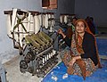 Woman doing a khadi training, Mahatma Gandhi Seva Ashram, Jaura
 -
 Girls playing hopscotch, Jaura
 -
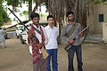 Men with guns, Jaura
 -
 Monsoon, Jaura
 -
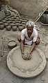
 Potter and his work, Jaura
-
 Potter at work, Jaura
 -
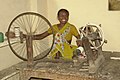 Woman spinning, Jaura
 -
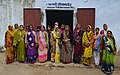 Women doing a khadi training, Jaura
 -
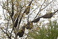 Bee swarms, Jaura


References[edit]
- ^ "Census of India 2011: Data from the 2011 Census, including cities, villages and towns (Provisional)". Census Commission of India. Retrieved 1 November 2008.
- ^ "List of village in Joura tehsil | Janmangaledu.in". www.janmangaledu.in. Retrieved 23 January 2023.
| International | |
|---|---|
| National | |
This article related to a location in Madhya Pradesh is a stub. You can help Wikipedia by expanding it. |