
Iyo-Doi Station
Y26 Iyo-Doi Station 伊予土居駅 | |
|---|---|
 Iyo-Doi Station in 2007 | |
| General information | |
| Location | Doicho Doi, Shikokuchūō-shi, Ehime-ken 799-0711 Japan |
| Coordinates | 33°57′32″N 133°25′42″E / 33.9589°N 133.4282°E |
| Operated by | |
| Line(s) | ■ Yosan Line |
| Distance | 88.6 km from Takamatsu |
| Platforms | 1 island platform |
| Tracks | 2 + several sidings |
| Construction | |
| Structure type | At grade |
| Accessible | Yes - island platform accessed by level crossing |
| Other information | |
| Status | Unstaffed |
| Station code | Y26 |
| History | |
| Opened | 1 September 1919 |
| Passengers | |
| FY2019 | 644 |
| Location | |
 Iyo-Doi Station Location within Ehime Prefecture  Iyo-Doi Station Iyo-Doi Station (Japan) | |
Iyo-Doi Station (伊予土居駅, Iyo-Doi-eki) is a passenger railway station located in the city of Shikokuchūō, Ehime Prefecture, Japan. It is operated by JR Shikoku and has the station number "Y26".[1][2]
Lines[edit]
Iyo-Doi Station is served by the JR Shikoku Yosan Line and is located 88.6 km from the beginning of the line at Takamatsu.[3] Yosan line local, Rapid Sunport, and Nanpū Relay services stop at the station.[4]
Layout[edit]
The station consists of an island platform serving two tracks. A station building beside the tracks is unstaffed and serves only as a waiting room. Access to the island platform is by means of a level crossing. A passing siding runs to the side of platform/line 1 and it is necessary to cross it on the way to the island platform. Several other dead-end sidings branch of the tracks.[2][5][6][3]
-
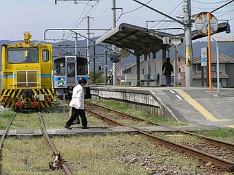 A passenger uses the level crossing to reach the island platform. On the left, the passing siding is being used by a track maintenance vehicle.

Adjacent stations[edit]
| « | Service | » | ||
|---|---|---|---|---|
| Yosan Line | ||||
| Akaboshi | Rapid Sunport | Sekigawa | ||
| Akaboshi | Nanpū Relay | Sekigawa | ||
| Akaboshi | Local | Sekigawa | ||
History[edit]
Iyo-Doi Station opened on 1 September 1919 as the terminus of the then Sanuki Line which had been extended westwards from Iyo-Mishima. It became a through station on 21 June 1921 when the line was further extended to Iyo-Saijo. At that time the station was operated by Japanese Government Railways, later becoming Japanese National Railways (JNR). With the privatization of JNR on 1 April 1987, control of the station passed to JR Shikoku.[7][8]
Surrounding area[edit]
- Japan National Route 11
- Enmei-ji Temple
- Ehime Prefectural Doi High School
- Shikokuchuo Municipal Doi Junior High School
- Shikokuchuo Municipal Doi Elementary School
See also[edit]
References[edit]
- ^ "Shikoku Railway Route Map" (PDF). JR Shikoku. Retrieved 27 December 2017.
- ^ a b "伊予土居" [Iyo-Doi]. hacchi-no-he.net. Retrieved 30 December 2017.
- ^ a b Kawashima, Ryōzō (2013). 図説: 日本の鉄道 四国・九州ライン 全線・全駅・全配線・第2巻 四国西部エリア [Japan Railways Illustrated. Shikoku and Kyushu. All lines, all stations, all track layouts. Volume 2 Western Shikoku] (in Japanese). Kodansha. pp. 10, 66. ISBN 9784062951616.
- ^ "Iyo-Doi Station Timetable" (PDF). JR Shikoku. Retrieved 30 December 2017.
- ^ "伊予土居駅" [Iyo-Doi Station]. shikoku.org.uk. Retrieved 30 December 2017.
- ^ "伊予土居" [Iyo-Doi]. sanyukai.sakura.ne.jp. Retrieved 30 December 2017.
- ^ Ishino, Tetsu; et al., eds. (1998). 停車場変遷大事典 国鉄・JR編 [Station Transition Directory – JNR/JR] (in Japanese). Vol. II. Tokyo: JTB Corporation. p. 635. ISBN 4-533-02980-9.
- ^ Ishino, Tetsu; et al., eds. (1998). 停車場変遷大事典 国鉄・JR編 [Station Transition Directory – JNR/JR] (in Japanese). Vol. I. Tokyo: JTB Corporation. pp. 213–215. ISBN 4-533-02980-9.
External links[edit]
![]() Media related to Iyo-Doi Station at Wikimedia Commons
Media related to Iyo-Doi Station at Wikimedia Commons