
Icoaraci
This article needs additional citations for verification. (February 2023) |
Icoaraci | |
|---|---|
| Administrative District of Icoaraci | |
 Icoaraci waterfront | |
| Country | |
| Region | North |
| State | |
| City | Belém |
| Founded | October 8, 1869[1] |
| Population | |
| • Total | 200,000[2] |
Icoaraci is one of the eight districts in which the municipality of Belém, capital of the state of Pará, in Brazil, is divided. It is located approximately 20 km from the center of the state capital and has around 200,000[3] inhabitants, according to the IBGE. It is situated near the Outeiro island, which can be accessed by boat at the port of 7th street or by a bridge. In Icoaraci you can also take daily ferries to Marajó Island and boats to Cotijuba Island, which can only be reached this way.[4][5]
The district center comprises the neighborhoods Águas Negras, Agulha, Campina de Icoaraci, Cruzeiro, Maracacuera, Paracuri, Parque Guajará, Xiteua, Recanto Verde, COHAB, Ponta Grossa, Pratinha, and several residential areas. It has a Human Development Index (HDI) lower than many African countries and regions at war, such as Syria, Afghanistan and Iraq.
Its original nucleus, from which it expanded, retains the terms travessas (English: lane) and ruas (English: streets), the latter called daily in the order of their foundation: 1st, 2nd, and so on until it reaches 7th street.[6]
Toponym[edit]
Icoaraci is a word of Tupi origin that means "sun of the river", from the junction of y (water, river)[7] and kûarasy (sun).[8]
Economy[edit]
The economy of Icoaraci is based on an industrial park that shelters, mainly, the fishing, wood, carpentry, and heart of palm branches. Another economic hub of the district is the open-air market of Oito de Maio, one of the busiest in Belém and the most frequented in Icoaraci, located in the Campina neighborhood. In addition, the district has three large warehouses, the so-called "atacarejos", a mixture of wholesale and retail foodstuffs.[9]
However, Icoaraci really stands out as an important ceramic handicraft center, installed in the Paracuri neighborhood, where replicas of typical vessels from ancient indigenous nations, mainly Marajoara and Tapajonic, are produced from pieces catalogued by the Paraense Emílio Goeldi Museum.
This art guarantees immeasurable importance to the place, especially cultural, not only for Belém or for Pará, but for the Amazon region, since it is also home to several folkloric groups of typical dances (Asa-Branca, Vaiangá, Balé Folclórico da Amazônia, Grupo de Expressões Culturais Art Marajoara), of musicians (Mestre Verequete, Nazaré Pereira) and of the poet Antônio Tavernard, among other exponents of Amazonian art who still live there, such as Mestre Cardoso (potter) and professor Etelvina (folk dancer), both pioneers in their art.[9]
The district has a good electrical and telecommunication structure, besides the structure of services such as banks, hospitals, forum, registry office, supermarkets, several schools, churches, taxi services and ridesharing. Icoaraci remains as an important center where small riverside municipalities and nearby neighborhoods converge.
Tourism is strong in Vila Sorriso, with the exhibition of indigenous ceramics in São Sebastião Square, right on the shore bathed by Guajará Bay, where the visitor is well served by a gastronomic pole composed of typical Pará cuisine (tacacá, maniçoba, pato-no-tucupi), with emphasis on the caldeirada with Amazon river fruits that can be found in the restaurants and kiosks surrounding Cruzeiro Beach.
Tourist attractions[edit]
.jpg)
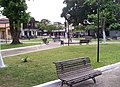
Icoaraci waterfront: the district's main tourist attraction. Icoaraci carries the history of the capital of Pará and, until today, is the right spot for tourists who are looking for a pleasant place to relax in contact with nature, in a bucolic charm.
- Cruzeiro Beach
- Paracuri Handicraft Fair
- Museum of Popular Art
- Avertano Rocha Municipal Library
- Outeiro Island
- Cotijuba Island
- Artisans' Cooperative - COART
- Icoaraci Cultural Station, 2019 (Pinheiro's Old Railway Station)[10][11]
Access[edit]

Streets, Lanes and Avenues[edit]
- Doutor Lopo de Castro Avenue (former Cristovão Colombo Lane)
- Siqueira Mendes Lane (1st Street)
- Outeiro Road
- 8 de Maio Street
- 15 de Agosto Street (4th street)
- Coronel Juvêncio Sarmento Street (5th Street)
- Manoel Barata Street (2nd Street)
- Padre Júlio Maria Street (3rd street)
- Santa Izabel St. (6th street)
- 2 de Dezembro (7th street)
- Berredos Lane
- Itaboraí Lane
- Moura Carvalho Lane
- Souza Franco Lane
- São Roque Lane
- Soledade Lane
- Chico Mendes Street (Paracuri II neighborhood)
- Tiradentes Street (Paracuri II neighborhood)
- Castelo Branco Street (Paracuri II neighborhood)
- Ferreira Lane (Paracuri II neighborhood)
Culture[edit]
- Avertano Rocha Municipal Library
- Museum of Popular Art
- Paracuri High School of Arts and Crafts "Mestre Raimundo Cardoso
- Icoaraci Cultural Station (Pinheiro's Old Railway Station)
Gallery[edit]
-
 Icoaraci Port.
 -
 Police Station Square.
 -
 Padre Julio Maria Street.
 -
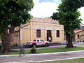 Icoaraci Police Station.
 -
 Saint John the Baptist Church Square.


References[edit]
- ^ "Aniversário de 140 anos de Icoaraci tem cultura e cidadania". Portal ORM. 2012-07-14. Retrieved 2012-07-14.
- ^ "ESTUDO DAS ÁREAS VERDES E INDICE DE COBERTURA VEGETAL DO DISTRITO ADMINISTRATIVO DE ICOARACI – DAICO, BELÉM-PA" (PDF). Revista Geonorte. 2012-07-14. Archived from the original (PDF) on 2015-09-24. Retrieved 2012-07-14.
- ^ RedePará. "Distrito de Icoaraci completa 150 anos e moradores celebram as belezas do local". REDEPARÁ. Retrieved 2012-01-22.
- ^ "Revisão do Plano Diretor do Município de Belém". Belém City Hall. 2012-07-14. Retrieved 2012-07-14.
- ^ "DISTRITOS ADMINISTRATIVOS DO MUNICÍPIO DE BELÉM" (PDF). Belém City Hall. 2012-07-14. Retrieved 2012-07-14.
- ^ "Icoaraci: as primeiras ruas". Icoaraci Online. 2012-07-14. Archived from the original on 2010-09-05. Retrieved 2012-07-14.
- ^ NAVARRO, E. A. Método moderno de tupi antigo: a língua do Brasil dos primeiros séculos. Terceira edição revista e aperfeiçoada. Segundo historiadores modernos Icoaraci também significa " Mãe de todas as águas".São Paulo. Global. 2005. p. 22.
- ^ NAVARRO, E. A. Método moderno de tupi antigo: a língua do Brasil dos primeiros séculos. Terceira edição revista e aperfeiçoada. São Paulo. Global. 2005. p. 108.
- ^ a b "IPontos Turísticos: Icoaraci". Guia da Semana. 2012-08-04. Retrieved 2012-07-14.
- ^ "Pinheiro -- Estações Ferroviárias do Pará". Estações Ferroviarias. Retrieved 2020-10-09.
- ^ "Obras e reformas". Secretary of Culture of Pará. Retrieved 2022-03-21.