
History of Lae
| History of Papua New Guinea |
|---|
 |
|
|
As the township of Lae, in Morobe Province, Papua New Guinea is a relatively new entity, the history of the Lae environs is much older.
Archaeology[edit]
Humans have been in New Guinea for as long as 60,000 years, according to archaeological evidence, although this is under debate.[1][2]
Recent archaeological research suggests that 50,000 years ago, people may have occupied sites in the highlands at altitudes of up to 2000 metres, rather than being restricted to warmer coastal areas.[3]
European contact[edit]
Russian anthropologist Nicholai Miklukho-Maklai made a number of expeditions to New Guinea, spending several years living among native tribes, and described their way of life in a comprehensive treatise.[4][5][6][7]
In 1793, Antoine Bruni d'Entrecasteaux sailed up tail of New Guinea into the Gulf he named Houn de Kermadec.[8][9][10][11]
In 1856, Italian Catholic priests arrived at Mandok Island, Siassi before being forced to leave by disease.[8][9][10][11]
In 1874, John Moresby on HMS Basilisk sails along Huon Gulf and names Parsee Point (Salamaua), the Markham, Rawlinson Ranges, and explores around the Markham mouth.[8][9][10][11]
The history of Lae township, according to Lucas (1972)[12] can be classified into four periods; the mission phase (1886–1920), the gold phase (1926 until World War II), the timber and agricultural phase (until 1965) and the industrial boom from 1965 with the opening of the Highlands Highway.[13]
1800s[edit]

German traders[edit]
The first Germans were probably from the Dutch East India Company: during Abel Tasman's first voyage.[14][15]
Until the 1871 unification, Germany had not concentrated on the development of a navy, and this essentially had precluded German participation in earlier imperialist scrambles for remote colonial territory – the so-called "place in the sun".[16] [a]
Many Germans in the late 19th century viewed colonial acquisitions as a true indication of having achieved nationhood. Public opinion eventually arrived at an understanding that prestigious African and Pacific colonies went hand-in-hand with dreams of a High Seas Fleet. Both aspirations would become reality, nurtured by a press replete with Kolonialfreunde [supporters of colonial acquisitions] and by a myriad of geographical associations and colonial societies. Bismarck and many deputies in the Reichstag had no interest in colonial conquests merely to acquire square miles of territory.[16][b]
In the late 1870s and early 1880s, an active minority in Germany consisting of Kolonialverein of 1882 and the Society for German Colonization (Gesellschaft für Deutsche Kolonisation)[17] tried to persuade Chancellor Bismarck to embark on a colonial policy with no success.
Eventually Bismarck organised the acquisition of much of what would become the German colonial empire.[18]
On 23 June 1884, Bismarck told the Reichstag that annexations would now proceed but by grants of charters to private companies.[18][c]
Hanseatic League merchant houses were the first to establish footholds: Johann Cesar Godeffroy & Sohn of Hamburg, headquartered at Samoa from 1857, operated a South Seas network of trading stations especially dominating the copra trade and carrying German immigrants to various South Pacific settlements with Godeffroy and Son estimated to control as much as 70 per cent of the commerce of the South Seas.[18][19][d][20][e]
Hernsheim and Robertson, established a German community on Matupi Island, in Blanche Bay (the north-east coast of New Britain) from which it traded in New Britain, the Caroline, and the Marshall Islands.[19][21]

The German effort included the first commercial endeavours in the 1850s and 1860s in West Africa, East Africa, the Samoan Islands and the unexplored north-east quarter of New Guinea with adjacent islands later Kaiser-Wilhelmsland and the Bismarck Archipelago. German traders and merchants began to establish themselves in the African Cameroon delta and the mainland coast across from Zanzibar.[16] The West and East Africa firms at Apia and the settlements of Finschhafen, Simpsonhafen and the islands Neu-Pommern and Neu-Mecklenburg, trading companies newly fortified with credit began expansion into coastal landholding.[22][f]
As Bismarck was converted to the colonial idea by 1884, he favoured "chartered company" land management rather than a colonial government setup due to financial considerations.[16] He reluctantly acquiesced to pleas for help to deal with revolts and armed hostilities by often powerful rulers whose lucrative slavery activities seemed at risk. German native military forces initially engaged in dozens of punitive expeditions to apprehend and punish freedom fighters, at times with British assistance.[23][g]
By the end of 1875, one German trader reported: "German trade and German ships are encountered everywhere, almost at the exclusion of any other nation".[18][h]
German New Guinea Company[edit]

The German New Guinea Company (German: Deutsche Neuguinea-Kompagnie) was founded in 1884 at Berlin by Adolph von Hansemann and a syndicate of German bankers for the purpose of colonising and exploiting resources on Neu Guinea (German New Guinea), where German interest grew after British Queensland's annexation of part of eastern New Guinea.[24]
Between 1879–1882, ornithologist and explorer Dr Otto Finsch was secretly tasked by German Chancellor Count Otto von Bismarck to expeditiously select land for plantation development on the north-east coast of New Guinea and establish trading posts. On his return to Germany, Otto Finsch joined a small, informal group interested in German colonial expansion into the South Seas led by the banker, Adolph von Hansemann. Finsch encouraged them to pursue the founding of a colony on the north-east coast of New Guinea and the New Britain Archipelago even providing them with an estimate of the costs of such a venture.[25]
While the western half of New Guinea had been administered by the Netherlands since 1828, the eastern half was not annexed by any European power until the 1880s. In 1883, fearful of growing foreign influence, particularly the influence of Germany, the British colony of Queensland annexed the south-eastern part of New Guinea, against the wishes of the British government.[26][i]
This initiated German interest in the remaining third of the island and on 3 November 1884, under the auspices of the Deutsche Neuguinea-Compagnie (New Guinea Company), the German flag was flown over Kaiser-Wilhelmsland, the Bismarck Archipelago and the German Solomon Islands.[26][j]
On 17 May 1885, the German Emperor granted an Imperial charter to the newly founded Neuguinea-Kompanie (New Guinea Company) for this annexation, which was further extended to the Solomon Islands on 13 November 1886.[26][k]
For the first fifteen years the colony was administered under imperial charters by a private company, in the manner of the old British and Dutch East India company, but with far less success. When the Imperial Government took over the running of the colony in 1899, its overriding objective was rapid economic development, based on a German-controlled plantation economy.[24]
To expand the highly profitable plantations the Germans needed more native workers. The government sent military expeditions to take direct control of more areas 1899 to 1914. The government enforced new laws that required the tribes to furnish four weeks of labour per person annually and payment of a poll tax in cash, thereby forcing reluctant natives into the work force. The planters protested and the government responded by sending troops.[27]
Kaiser-Wilhelmsland[edit]

German New Guinea (German: Deutsch-Neuguinea) was the first part of the German colonial empire. The mainland portion, Kaiser-Wilhelmsland, was formed from the northeastern part of New Guinea. The islands to the east of Kaiser-Wilhelmsland, on annexation, were renamed the Bismarck Archipelago (formerly the New Britannia Archipelago) and the two largest islands renamed Neu-Pommern ("New Pomerania", today's New Britain) and Neu-Mecklenburg ("New Mecklenburg, now New Ireland).[26][l][28]
The economic life of German New Guinea's small population of European and Asian settlers, as well as that of its Melanesian population, relied heavily on the export of copra and the import of goods and services.[29]
Lutheran and Catholic missionaries[edit]
By the mid-1880s, German church authorities had devised a definite program for missionary work in New Guinea and assigned it to the Rhenish Mission, under the direction of Friedrich Fabri (1824–91), a Lutheran. The missionaries faced extraordinary difficulties: repeated sickness from the unhealthy climate; psychological and sometimes violent tensions and fights between the colonial administration and the natives. The natives rejected European customs and norms of social behaviour; few embraced Christianity. In 1921, the Rhenish Mission territory was handed over to the United Evangelical Lutheran Church of Australia.[30]
The mission society provided clergy and religious education for Lutheran settlements in Missouri, Iowa and Ohio, Australia, and anywhere else "free thinking" Lutherans had settled.[31]
On 12 July 1886, a German missionary, Johann Flierl, a pioneer missionary for the Southern Australian Lutheran Synod and the Neuendettelsau Mission Society, sailed to Simbang in Finschhafen, Kaiser-Wilhelmsland and arrived at Lae shortly after.[32]
Flierl sailed from the Cooper Creek mission in South Australia towards German New Guinea stopping at Queensland to establish the Cape Bedford Mission and Elim Mission.
At the time two groups of Germans inhabited Kaiser-Wilhelmsland. The largest group were the entrepreneurs, plantation owners, officials of the German New Guinea Company, and government functionaires living in Finschhafen and Madang, and at plantations along the coast. They viewed groups they encountered, differently than did the evangelical Lutherans at Finschhafen, Sattelberg, and the filial mission statements along the coast.[31][m]
Following a dispute with the German New Guinea Company, Pastor Gottfried Schmutterer from the Neuendettelsau Mission Society was forced to relocate his original mission camp in July 1912 and was offered a location on the banks of the Bumbu known as Ampo. The Ampo Lutheran Church was built in 1937 and later used as a WW2 field hospital and remains the oldest building in Lae. Several Lutheran churches, schools and headquarter buildings now occupy the surrounds.[33]
In the 1920s, the Lutheran Church had a significant impact on the Butibum and Malahang communities and garnered a great deal of loyalty to the faith. By way of example, in 1971, the Roman Catholic mission decided to erect a church in the Bumbu settlement to serve the Sepik community there. The Butibum people generally regarded this move as sacrilege because they believed their lands, on which the new church stands, are hallowed by the Lutheran faith.[33]
1900s[edit]
In the first years of the 20th century, shipping lines had established scheduled services with refrigerated holds and agricultural products from the colonies, exotic fruits and spices, were sold to the public in Germany proper. Geologists and cartographers explored what were the unmarked regions on European maps, identifying mountains and rivers, and demarcating boundaries. Hermann Detzner and one Captain Nugent, R.A., had charge of a joint project to demarcate the British and German frontiers of Cameroon, which was published in 1913.[34]
Travelers and newspaper reporters brought back stories of black and brown natives serving German managers and settlers. There were also suspicions and reports of colonial malfeasance, corruption and brutality in some protectorates, and Lutheran and Roman Catholic missionaries dispatched disturbing reports to their mission headquarters in Germany.[35][n]


In 1900, the Neuendettelsau Mission Society imported cattle from Australia to the mission stations at Malahang and Finschhafen however Tick fever caused many losses. Eventually the Malahang mission sold cattle to locals for $70 per head.[36]
In 1910, the Gabmatsung/Gabmazung Lutheran mission station was established at Nadzab.[37] and established an airfield for use by small planes until the outbreak of the Pacific War when it became overgrown with dense kunai grass.[38]
In 1914, the Neuendettelsau Mission Society purchased land for their plantation and gave a gift of cattle to the local people.[39]
In 1919, the Melbourne Argus newspaper ran this classified advertisement:
- The following items, collected by on Official with the Aid of An Armed Force from Gabmatsung (and other districts) -carved figures, stone clubs, carved plates, bows and arrows, spears, native drum, clubs, horns, modlooms, native pillows, head dresses, bags, shells ornaments and butterflies. JW Styles and Son, Glenhuntly Rd, Caufield[40]
In the years before the outbreak of the Great War, British colonial officers viewed the Germans as deficient in "colonial aptitude", but "whose colonial administration was nevertheless superior to those of the other European states.[41][o]
World War 1[edit]

Following Britain's declaration of war on Imperial Germany on 4 August 1914 and the outbreak of the First World War, Australia and the other members of the British Empire were automatically involved.[42][p] Within days, the creation of the Australian Imperial Force (AIF) was created and on 6 August 1914, London cabled its acceptance of the force and asked that it be sent as soon as possible.[43][q]
Meanwhile, after an additional British request for assistance on 6 August 1914, the Australian government hurriedly prepared another expeditionary force (Australian Naval and Military Expeditionary Force) to destroy the German wireless stations at Yap in the Caroline Islands, Nauru, and Rabaul (Battle of Bita Paka)in New Britain.[44][r]
Following the Cameroon surveying project, Hermann Detzner was tasked to survey the border of Australian Papua and Kaiser-Wilhelmsland and during this expedition and unbeknownst to Detzner, war was declared. In his book published in 1920, Vier Jahre unter Kannibalen ("Four Years among Cannibals") Detzner claims to have penetrated the interior of Kaiser-Wilhelmsland but these claims were disputed by various German missionaries and later recanted in 1932.[45][s]
On 24 September, the German colony at Madang on Kaiser-Wilhelmsland (the New Guinea mainland) was occupied by the Australian forces. Shortly after all remaining German possessions were captured in the region and the Australian Naval and Military Expeditionary Force provided occupation forces for the duration of the war.[26][t] The military government continued until 1921.[44] The Australian military administration continued the exploitative economic policies of the previous German colonial administration, and official policy was to continue the status quo, including the use of indentured Melanesian labor on plantations, the levy of the "native head tax" and official floggings, or corporal punishment.[26][u] Under the terms of the German surrender, German civilians could remain as long as they swore an oath of neutrality. Those who refused were later transported to Australia, where they could freely travel back to Germany.[46][v]
Both in the British Empire and, eventually in the United States, it was feared that Germany eventually would make a bid for world hegemony by means of an African conscript army. The Allies felt they had a responsibility to protect the natives from Prussian militarism and German technological developments which would threaten the security of the British Empire[26][w]
On 9 January 1915, command of the colony was handed over to Brigadier General Sir Samuel Pethebridge, the former Secretary of the Department of Defence.[26][x] Although required by international law to follow the German forms of government, the territory gradually acquired the appearance of a British colony.[26][y] As a result of the peace settlement under the Treaty of Versailles in 1919, Germany lost all of its colonial possessions, including German New Guinea. The colony became the Territory of New Guinea, a League of Nations Mandate Territory under Australian administration. It remained as such until 1949, when it was merged with the Australian territory of Papua to become the Territory of Papua and New Guinea, which eventually became modern Papua New Guinea.
Confiscation[edit]
(see List of former German colonies)
Germany's overseas empire was dismantled following defeat in World War I. With the concluding Treaty of Versailles, Article 22, German colonies were divided between Belgium, the United Kingdom, and certain British Dominions, France, and Japan with the determination not to see any of them returned to Germany – a guarantee secured by Article 119.[41][z]
In the Pacific, Japan gained Germany's islands north of the equator (the Marshall Islands, the Carolines, the Marianas, the Palau Islands) and Kiautschou in China. German Samoa was assigned to New Zealand; German New Guinea, the Bismarck Archipelago and Nauru Australia in effective control, formally together with United Kingdom and New Zealand to Australia.[41][aa] President Wilson saw the League of Nations as "'residuary trustee' for the [German] colonies" captured and occupied by "rapacious conquerors".[35]
After World War I, many of the Germanic names were replaced by English or Indigenous ones. Adolf Haven was then referred to as Morobe Harbor.[47]
Soon after the establishment of British New Guinea in the 1880s, a system of patrols Kiaps was established to expand the government's administrative control beyond the major towns. The system continued after the change from British to Australian administration in 1905. The Kiap system was used following the League of Nations Mandate. The kiaps patrolled at a time when cannibalism was still practised in parts of PNG.[48]
Australian Officials or Kiaps were stationed at various locations within the province[49] and in 1921, the military administration transitioned to a civilian administration, a gold prospector named Cecil John Levien was appointed District Officer (Kiap) of Morobe.
1920–1930[edit]
On 1 January 1923, Levien acquired a mining right for the area and shortly after formed a syndicate called "Guinea Gold (No Liability)".[50]
The Guinea Gold syndicate formed Guinea Airways Limited in November 1927.[51]
In 1927, Levien arranged for the construction of the airstrip at Lae to assist the gold mine productions around Wau.[52]
The first flight into the airfield was a DH-37 flown by E. A. "Pard" Mustar. The aircraft was shipped from Essendon Airport to Rabaul on the S.S. Melusia[53] and flown to Lae on 31 March 1927.
From 1922 to 1942, the airfield was part of a massive airlift operation to service the Bulolo goldfields and was one of the largest airlift operations in the world.[54] Junkers W34 tri-motor planes were ideal and the German Junkers aeroplanes played a major part in the exploration and development of what is today Papua New Guinea. To mine the gold required the construction on site of several 1500+ ton dredges with the heaviest part scaling over 3 tons.
The first Junkers W34 B, VH-UGZ (c/n 2601 CoR 195-crashed Wau 6 March 1930[55]), was bought disassembled in big crates to New Guinea and made its test flight on 10 April 1928. The first two G31s were called Peter and Paul, the third simply G31. This aircraft could carry two passengers and a ton of freight in the cargo compartment. In the first 19 days of operation the W34 No 1 earned gross revenue of £2,649 with field costs of £360. The second W34 was ordered on 8 June 1928 and arrived in December. By then No 1 W34 had carried 500 passengers and 300 tons of freight. Guinea Airways eventually purchased five of these simple, rugged and honest Junkers machines unmatched at the time by any other manufacturer. The aircraft could be loaded or unloaded in 15 minutes through a large open hatch on the roof with the gantry crane above the aircraft.[56]
Lae was declared a town under the New Guinea Boundaries Ordinance on 31 March 1931 at the height of the gold rush era.[57]
Lae became the prototype for New Guinean towns built up around airstrips.[13]
The main township of Lae was originally on the flats between Voco Point and the airfield. The site was later shifted to the terraces above where the elite had lived in the days before the war.[13]
The Europeans lived to the East of Lae Airfield while the New Guineans lived to the West.[13] Cargo arrived in Lae and then was transported by air to the goldfields in Wau.
1930–1945[edit]
In July 1937, Lae made world news when American aviator Amelia Earhart was last seen flying out of the airport on her way back to the United States. She was never seen again.
When the volcanic eruptions occurred in Rabaul in 1937, a decision was made to transfer the capital of the Territory of New Guinea to Lae. World War II got in the way of the transfer and the town was occupied by the Empire of Japan on 8 March 1942. Lae, Rabaul and Salamaua became the major Japanese bases in New Guinea.
World War 2[edit]

On 8 March 1942, the Imperial Japanese landed at Malahang Beach as part of the Invasion of Lae-Salamaua during World War II. Malahang airfield was upgraded by the Japanese so the runway was 800 feet (240 m) long by 50 feet (15 m) wide and used as satellite of Lae Airport.
The naval Battle of the Bismarck Sea in March 1943 was fought over the Japanese attempt to reinforce Lae with troops sent by sea from Rabaul, an attempt foiled by sustained Allied attack on the Japanese troop transports. In mid-1943, after defeats in the Kokoda Track campaign, the Battle of Buna–Gona and the Battle of Wau, the Japanese retreated to Lae and Salamaua. However, the Salamaua–Lae campaign involved many weeks of fierce fighting, before the town fell to the Allies on 16 September.
Lyndon B. Johnson was appointed Lieutenant Commander in the United States Naval Reserve on 21 June 1940. Eleven B-26 Marauder's of the 22nd Bomb Group departed Townsville on 8 June 1942, arrived in Port Moresby and raided Lae on 9 June 1942. The mission was called "TOW 9" and Lieutenant Commander Johnson, the future 36th President of the United States, went on this raid as an observer on the aircraft, the Heckling Hare. [ab][ac] Nine days after the raid, Johnson was awarded a Silver Star medal for his participation in the above bombing raid.[58][59][60]
The Landing at Nadzab was the first parachute jump for the 503rd Parachute Regiment on 5 September 1943. In conjunction with the Amphibious Landing East of Malahang, was to be the start of the liberation of Lae from Japanese Occupation.[37] On 4 September, the Australian 9th Division, under Major General George Wootten, landed east of Lae, on "Red Beach" and "Yellow Beach", near Malahang. The 2/13th Battalion (20th Brigade) landed at Yellow Beach and pushed east, on toward Hopoi Mission Station West and then to Finschhafen.[61]

Situm is located to the north of the beaches where the Australian 7th Division carried out an amphibious landing in September 1943, as part of plans to capture Lae from the Japanese during the Salamaua–Lae campaign. During that campaign and the subsequent advance into the Finisterre Range, the locals assisted the Allied troops and after the war, the Australian 7th Division AIF Association helped construct a school at Situm in 1964 as a form of gratitude.[62]
The 68th Australian Women's Army Service barracks was located on Butibum Road at the base of Mount Lunaman near the present location of Sir Ignatius Kilage Stadium.[ad] The barracks were constructed by army engineers and New Guinean workers and the compound perimeter was enclosed by a high barbed wire fence patrolled by armed guards. Many women considered the high fences a symbol of constraint and the popular song Don't Fence me In, was often sung.[63]
Before the construction of the Highlands Highway, a road in the Atzera foothills in the Markham Valley connected Nadzab with Lae and a rough trail on the other side of the Atzeras paralleled this road from Lae to Yalu. Edward's Plantation was located around 5 Mile, Heath's Plantation around 6 Mile, Lane's Plantation and Whittaker's Plantation around 9 Mile and Jensen's Plantation around 10 Mile.[64] On 10 September the 25th Australian Infantry Brigade moved East from Nadzab towards Lae along the Atzera foothills often with fierce battles through these plantations while the 9th Division approached Lae from the East. On 16 September both units converged on Lae.[65]
After Lae was liberated from Japanese occupation, 7th Division's Brigadier Eather set off by jeep to replace the Japanese flag on Mount Lunamen with the Australian flag.[66][67]
1945–1970[edit]
In 1954, Australian farmers assisted the Malahang mission further establish their herd: "Twenty five Shorthorn heifers have been flown from Cairns in North Queensland, to Lae in New Guinea, to form the nucleus of a beef herd at the Lutheran Mission there. The heifers were donated to the mission by Mr. A.W Anderson and were aged from 11 to 13 months. They averaged 400 lb. each. Two trips were made by an especially chartered DC3 to get the cattle to New Guinea. The cattle were brought from Julia Creek to Mackay and then taken to the Atherton Tableland where they were rested and inoculated. Twelve head were taken on the first trip. The landed cost of the heifers in Lae, which is about 650 miles from Cairns, was approximately £60 per head compared with £110 for the estimated cost of shipping. Charter fees for the DC3 were £1200. Mr, W. W. Meuser. who came to Cairns to supervise the loading of the shipment, said that Mr. P. Kidd, of Malanda, in North Queensland, would buy a Santa Gertrudis bull to mate with the heifers. The European and native staffs of the mission consume considerable amounts of beef"[68]
On 24 October 1959, the first Lae Agricultural show was run:
The Morobe Lae Showgrounds are located in Dowsett. The first Morobe Show was held in 1959, but on three occasions the Show had to be cancelled. In 1983, Lae was isolated by floods and in 1991, law and order problems caused a curfew to be imposed from 6 am to 6 pm. In 2009, an outbreak of cholera in the province made it unwise to have a large gathering of people.
Flora Shaw Stewart (1886–1979) was a founding member of the Morobe Agricultural Society and would often lead the grand parades at annual shows.[69]
In the livestock section, dairy cattle were the strongest exhibit. The cattle came from the Lutheran Mission at Malahang, Mrs. Jensen's dairy, both near Lae and the Department of Agriculture and Stock and Fisheries' (DASF) property Erap[70]
The mission owned 1,250 acres of coconut plantations;[71] produced copra; grew vegetables; raised poultry, cattle, and other animals; and operated sawmills.
The cattle herd was built up to more than 150 head and a dairy was established. In 1955 Tropical Dairies became the first in PNG to supply pasteurised milk in cartons. By 1961 Malahang was producing some 32,000 gallons of milk per year.[72]
In 1962, the main strip at Nadzab was resealed by the Australian Commonwealth Department of Works and lengthened to make it suitable for Mirage fighters, even though they never materialised. However, it was always maintained by the Australian Department of Civil Aviation as an alternative to Lae in poor weather conditions.[38]
Today, the former 'East Base' or No. 1 & No. 2 runways are still in use by Air Niugini and for civil aviation, mainly servicing Lae which is 45 kilometres (28 mi) away. Roads in the area were built by American forces.[73][74][75]


1970–1990s[edit]
In 1971, the Australian Colonial Administration established the first properly constituted Local Government of Lae town and in 1972, Lae was proclaimed a city.[76]
Lae's development after the war is directly linked to the development of the highlands. Coffee and tea were being grown and a port was needed. Later priority was given on road access, and the Highlands Highway came into existence. The mineral boom occurred in the 1980s and 1990s.
By 1977, the old Lae Airfield was not as popular as the Nadzab Airport, a United States Air Force base, became operational. Fierce political squabbling over the pros and cons of Lae and Nadzab continued until 1982, when, in an unsolved mystery, the Lae airport terminal was burned down.[54]

Lae airfield continued to be used by Air Niugini and other third-level airlines until 1987. It was also used as the base for the Papua New Guinea Defence Force until it was transferred to Port Moresby in 1992.[54]

Between December 1983 and July 1992, Lae experienced two major flood and mudslide disasters. In both cases, hundreds of people lost their homes. The 1983 floods remain the worst since the establishment of the town in the late 1920s. These floods left hundreds of people homeless particularly those living along the banks of the Bumbu River. Many houses were damaged or completely destroyed and hundreds of people at the Five Mile settlement along the Highlands Highway were also affected by mudslides.[77]
Meanwhile, provincial and national leaders met to find solutions to the problem of how to resettle people displaced by the disaster and to the north of the city a block of land was allocated, planned and developed for the resettlement of the disaster victims. This 'Tensiti' settlement was developed in 1992 on the former Serafini plantation with sealed road networks, water and electricity.[77]
During the 2007 floods, engineers were also working out how the flooding Bumbu River in Lae would be diverted to save residences at Admin Compound which were threatened by the floodwaters.[78]
In 1991, Lae and Port Moresby hosted the South Pacific Games.
In 1997, Lae City Authority became the Lae Urban Local Level Government Council.[79]
2000s[edit]
On 24 September 2011, the annual Papua New Guinea national rugby league team's match against the Australian Prime Minister's XIII took place outside Port Moresby for the first time at Sir Ignatius Kilage Stadium, which was packed to capacity for the match.[80]
Footnotes[edit]
- ^ in this effort and conjointly with his firm rejection of taking over the French colonial possessions after the Franco-Prussian war, Bismarck in February 1871 characterised a German acquisition of colonies as equivalent to the Polish nobility wearing silks and furs when they needed shirts
- ^ Reichstag deputy Friedrich Kapp stated in debate in 1878 that whenever there is talk of "colonization", he would recommend to keep pocketbooks out of sight, "even if the proposal is for the acquisition of paradise."
- ^ citing R. M. Smith (tr.) (1885) German Interests in the South Sea, abstracts of the White Book presented to the Reichstag, December 1884 and February 1885 and pinpoint reference 1884
- ^ p. 10
- ^ citing H. U. Wehler Bismarck und der Imperialismus (1969) pp 208–15; E. Suchan-Galow Die deutsche Wirtschaftsta"tigkeit in der Südsee vor der ersten Besitzergreifung (1884) (Vero"ffentlichung des Vereins für Hamburgische Geschichte, Bd. XIV, Hamburg, 1940
- ^ p. 106
- ^ p. 9
- ^ p 26 quoting Schleinitz to Admiralty, 28 December 1875, Drucksache zu den Verhandlungen des Bundesrath, 1879, vol. 1, Denkschrift, xxiv–xxvii, p. 3.
- ^ p. 2
- ^ p. 21-22
- ^ p. 22
- ^ p. 1-6
- ^ P.5
- ^ p. 178
- ^ p. 17-35
- ^ p. 58
- ^ p. 30
- ^ p. 86-87
- ^ p. 75-80
- ^ p. 105-126
- ^ p. 219-233
- ^ p. 37, Hiery suggests the German colonial policies in the Pacific were liberal when compared to the subsequent policies initiated by later administrations
- ^ p. 154–.364
- ^ p. 154–155
- ^ p. 154–364
- ^ p. 9
- ^ p. 9
- ^ The aircraft the Heckling Hare (#40-1488) was probably named after the cartoon The Heckling Hare.
- ^ The aircraft was also known as the Arkansas Traveller.
- ^ Location assumed from photographic analysis/ See external links.
Bibliography[edit]
- ^ O'Connella, J.F. (9 November 2003). "Dating the colonization of Sahul (Pleistocene Australia–New Guinea): A review of recent research" (PDF). Journal of Archaeological Science. 31 (6): 835–853. doi:10.1016/j.jas.2003.11.005. Archived from the original (PDF) on 3 November 2013. Retrieved 10 September 2014.
- ^ Alan J. Redd1, Mark Stoneking (September 1999). "Peopling of Sahul: mtDNA Variation in Aboriginal Australian and Papua New Guinean Populations". The American Journal of Human Genetics. 65 (3): 808–828. doi:10.1086/302533. PMC 1377989. PMID 10441589.
{{cite journal}}: CS1 maint: numeric names: authors list (link) - ^ "Early humans lived in PNG highlands 50,000 years ago". Reuters. 30 September 2010. Retrieved 21 June 2011.
- ^ Kratoska, Paul H. (2001). South East Asia, Colonial History: Imperialism before 1800, Volume 1 de South East Asia, Colonial History. Taylor & Francis. p. 56. ISBN 9780415215404.
- ^ Luis Filipe F. R. Thomaz (1995). "The image of the Archipelago in Portuguese cartography of the 16th and early 17th centuries". Archipel. 49. Persee: 79–124. doi:10.3406/arch.1995.3038.
- ^ "New Guinea, located just north of Australia, is the world's second largest island, having become separated from the Australian mainland when the area now known as the Torres Strait flooded after the last glacial period". Mural.uv.es. Retrieved 7 January 2016.
- ^ J.H.F. Sollewun Gelpke. "On the Origin of the name Papua" (PDF). Papuaweb.org. Archived from the original (PDF) on 13 July 2017. Retrieved 7 January 2016.
- ^ a b c Willis, Ian (1973). "History of Morobe District". Journal of the Morobe District Historical Society.
- ^ a b c Willis, Ian (1979). "History of the Morobe Province". Northeast New Guinea. 1. 1.
- ^ a b c Holzknecht, Phillip W (1977). "Survey of German exploration and contact in the Morobe Province of Papua New Guinea from 1884–1930". A Manuscript Held in the New Guinea Collection.
- ^ a b c Holzknecht, Phillip W. (compiler) (1977). "Towards a Morobe Province Bibliography". Journal of the Morobe District Historical Society. 2. 4: 57–62.
- ^ Lucas, John (June 1972). "Lae – A Town in Transition". Oceania. 4. 42 (4): 260–275. doi:10.1002/j.1834-4461.1972.tb01181.x. JSTOR 40330020.
- ^ a b c d Suzanne Romaine (1992). Language, Education, and Development: Urban and Rural Tok Pisin in Papua New Guinea. Oxford University Press. p. 114. ISBN 978-0-19-823966-6. Retrieved 16 February 2014.
- ^ "Abel Tasman". Project Gutenburg. publisherofweb. Retrieved 10 September 2014.
- ^ Heeres, J.E (1898). "Abel Janszoon Tasman's Journal". Gutenberg.net.au. Retrieved 10 September 2014.
- ^ a b c d Washausen, Helmut (1968). Hamburg und die Kolonialpolitik des Deutschen Reiches. [Hamburg and Colonial Politics of the German Empire]. Hamburg: Hans Christians Verlag. (p.21)
- ^ Hartmut Pogge vonStrandmann (1969). Domestic Origins of Germany's Colonial Expansion under Bismarck" (1969) Past & Present. location: Iowa State University.
- ^ a b c d Jürgen Ohff, Hans (2008). Empires of enterprise: German and English commercial interests in East New Guinea 1884 to 1914 (Thesis) (Thesis (PhD) ed.). University of Adelaide School of History and Politics. doi:10.4225/55/59e9603ddb7e4. hdl:2440/48479.
- ^ a b Townsend, Mary E. (1943). "Commercial and Colonial Policies". The Journal of Economic History. 3: 124–134. doi:10.1017/S0022050700083960. S2CID 153362946.
- ^ Kennedy, P .M. (1972). "Bismarck's Imperialism: The Case of Samoa, 1880–1890". The Historical Journal. 15 (2): 261–283. doi:10.1017/s0018246x00002569. S2CID 161173507.
- ^ Romilly, H.H (1887). "The Islands of the New Britain Group". Proceedings of the Royal Geographical Society and Monthly Record of Geography. New Monthly Series. 9 (1): 1–18. doi:10.2307/1801261. JSTOR 1801261.
- ^ Haupt, Werner (1984). Deutschlands Schutzgebiete in Übersee 1884–1918 [Germany's Overseas Protectorates 1884–1918]. Friedberg: Podzun-Pallas Verlag. ISBN 3-7909-0204-7.
- ^ Miller, Charles (1974). Battle for the Bundu. The First World War in East Africa. New York: MacMillan Publishing Co., Inc. ISBN 0-02-584930-1.
- ^ a b Linke, R (2006). "The influence of German surveying on the development of New Guinea" (PDF). Association of Surveyors of PNG. Retrieved 25 January 2014.
- ^ Sack, Peter (1980). German New Guinea: A Bibliography Finsch, Otto (1839–1917). Canberra: Australian National University. ISBN 9780909596477. Retrieved 10 September 2014.
- ^ a b c d e f g h i MacKenzie, Seaforth (1941). The Australians at Rabaul: The Capture and Administration of the German Possessions in the South Pacific. Official History of Australia in the War of 1914–1918, Volume X. (Tenth ed.). Canberra, Australian Capital Territory: Australian War Memorial. OCLC 494426919.
- ^ Firth, Stewart (1976). "The Transformation of the Labour Trade in German New Guinea, 1899–1914". Journal of Pacific History. 11 (1): 51–65. doi:10.1080/00223347608572290.
- ^ "Deutsch-Neuguinea: Kaiser-Wilhelms-Land und die Inselwelt im Stillen Ozean – deutsche Kolonie 1885–1919" (in German). 2000. Retrieved 4 November 2009.
- ^ Rowley, Charles (1958). The Australians in German New Guinea 1914–1921. Carlton, Victoria: Melbourne University Press. OCLC 378150.
- ^ Klaus, J. Bade (1975). "Colonial Missions And Imperialism: The Background to the Fiasco of the Rhenish Mission in New Guinea". Australian Journal of Politics and History. 21 (2): 73–94.
- ^ a b Garrett. New Schaff-Herzog Encyclopedia of Religious Knowledge. Vol. VII. Archived from the original on 22 July 2012. Retrieved 10 September 2014.
- ^ "Evangelical Lutheran Church of Papua New Guinea". website. publisherofweb. Archived from the original on 30 November 2012. Retrieved 10 September 2014.
- ^ a b Willis, Ian (1974). Lae, village and city (1. Aufl ed.). Carlton, Vic.: Melbourne University Press. ISBN 0522840760.
- ^ Detzner, Hermann, (Oberleut.). "Kamerun Boundary: Die nigerische Grenze von Kamerun zwischen Yola und dem Cross-fluss". M. Teuts. Schutzgeb. 26 (13): 317–338.
{{cite journal}}: CS1 maint: multiple names: authors list (link) - ^ a b Louis, Wm. Roger (1963). Ruanda-Urundi 1884–1919. Oxford: Clarendon Press.
- ^ 1965 Cattle, Coffee, and Land Among the Wain, Issue 8 of New Guinea Research Unit Bulletin accessed 31 January 2014
- ^ a b "Nadzab airborne operation". Official Website of the 503d Parachute RCT Association of World War II. Retrieved 28 February 2014.
- ^ a b Malum Nalu (24 April 2009). "Nadzab Airport". Retrieved 4 March 2014.
- ^ 1971 New Guinea and Australia, the Pacific and South-East Asia, Volume 6. Council on New Guinea Affairs, [1] accessed 31 January 2014
- ^ "Classified Advertising". The Argus (Melbourne, Vic1848 – 1957). 18 June 1919.
- ^ a b c Louis, Wm. Roger (1967). Great Britain and Germany's Lost Colonies 1914–1919. Oxford: Clarendon Press.
- ^ Odgers, George (1994). 100 Years of Australians at War. Sydney, New South Wales: Lansdowne. ISBN 1-86302-669-X.
- ^ MacDougall, Anthony (1991). Australians at War: A Pictorial History. Balgowlah, New South Wales: Reed Books. ISBN 1-86503-865-2.
- ^ a b Dennis, Peter; Grey, Jeffrey; Morris, Ewan; Prior, Robin; Bou, Jean (2008). The Oxford Companion to Australian Military History (Second ed.). Melbourne, Victoria: Oxford University Press. ISBN 978-0-19-551784-2.
- ^ Meade, Kevin (2005). Heroes Before Gallipoli: Bita Paka and that One Day in September. Milton, Queensland: John Wiley & Sons Australia. ISBN 1-74031-117-5.
- ^ Bean, Charles (1946). Anzac to Amiens. Canberra, Australian Capital Territory: Australian War Memorial. OCLC 28535580.
- ^ Wurm, S. Mühlhäusler, P, Tyron, D & de Gruyter, W 1996, Intercultural communication in Atlas of Languages of Intercultural Communication in the Pacific, Asia, and the Americas, Volume 1 to GoogleBooks
- ^ "STORY OF POMANOWAI". The Queenslander. National Library of Australia. 1 March 1919. p. 43. Retrieved 26 December 2013.
- ^ "Morobe Province Patrol Reports". Archived from the original on 7 January 2014. Retrieved 10 September 2014.
- ^ Kernot, C. (1999). aluing Mining Companies: A Guide to the Assessment and Evaluation of Assets, Performance, and Prospects in Business and Economics. CRC Press. ISBN 9780849317651. Retrieved 10 September 2014.
- ^ Healy, A. M. "Levien, Cecil John (1874–1932)". Australian Dictionary of Biography. Vol. 10. Retrieved 10 September 2014.
- ^ Rowan McKinnon; Jon Murray (1998). Papua New Guinea. Lonely Planet. ISBN 978-0-86442-402-0.
- ^ "WRECKSITE - MELUSIA PASSENGER/CARGO SHIP 1944-1945". Wrecksite.eu. Retrieved 7 January 2016.
- ^ a b c Nalu, Malum (3 December 2007). "Malum Nalu: The old Lae airport". Malumnalu.blogspot.com. Retrieved 7 January 2016.
- ^ "Civil Aircraft Register - Australia". Airhistory.org.uk. Retrieved 7 January 2016.
- ^ Linke, R 2006, The influence of German surveying on the development of New Guinea, Association of Surveyors of PNG. Accessed 25 January 2014.
- ^ Mason, L; Hereniko, P (1987). In Search of a Home. Fiji: University of the South Pacific. Institute of Pacific Studies. ISBN 9789820100169.
- ^ Noel Tunny (1991). Gateway to Victory: The Establishment of the First U.S. Armed Forces in Australia 1941–42 : 3rd Bomb Group (M), 7th Bomb Group (H), 19th Bomb Group (H), 22nd Bomb Group (M), 27th Bomb Group (L), 49 Fighter Group. N. Tunny. ISBN 978-0-646-08883-9.
- ^ Michael John Claringbould (1999). The Forgotten Fifth: A Photographic Chronology of the U.S. Fifth Air Force in the Pacific in World War Two. Aerothentic Publications of Australia.
- ^ Dunn, Peter. "Lyndon Baynes [sic] Johnson His Time in Townsville and the Bombing Raid on Lae "Tow 9" – 9 June 1942". Oz@War. Retrieved 2 March 2014.
- ^ Reconquest New Guinea 1943–44 (PDF). Returned Services League. Archived from the original (PDF) on 16 February 2015. Retrieved 23 September 2014.
- ^ "7th Infantry Division Returns to Situm (1/5/13) – Rotary Club of Lae". Rotarylae.org. 5 May 2013. Retrieved 7 January 2016.
- ^ "Australian Women's Army Service (AWAS)". Australia.gov.au. 7 May 1945. Archived from the original on 30 April 2014. Retrieved 7 January 2016.
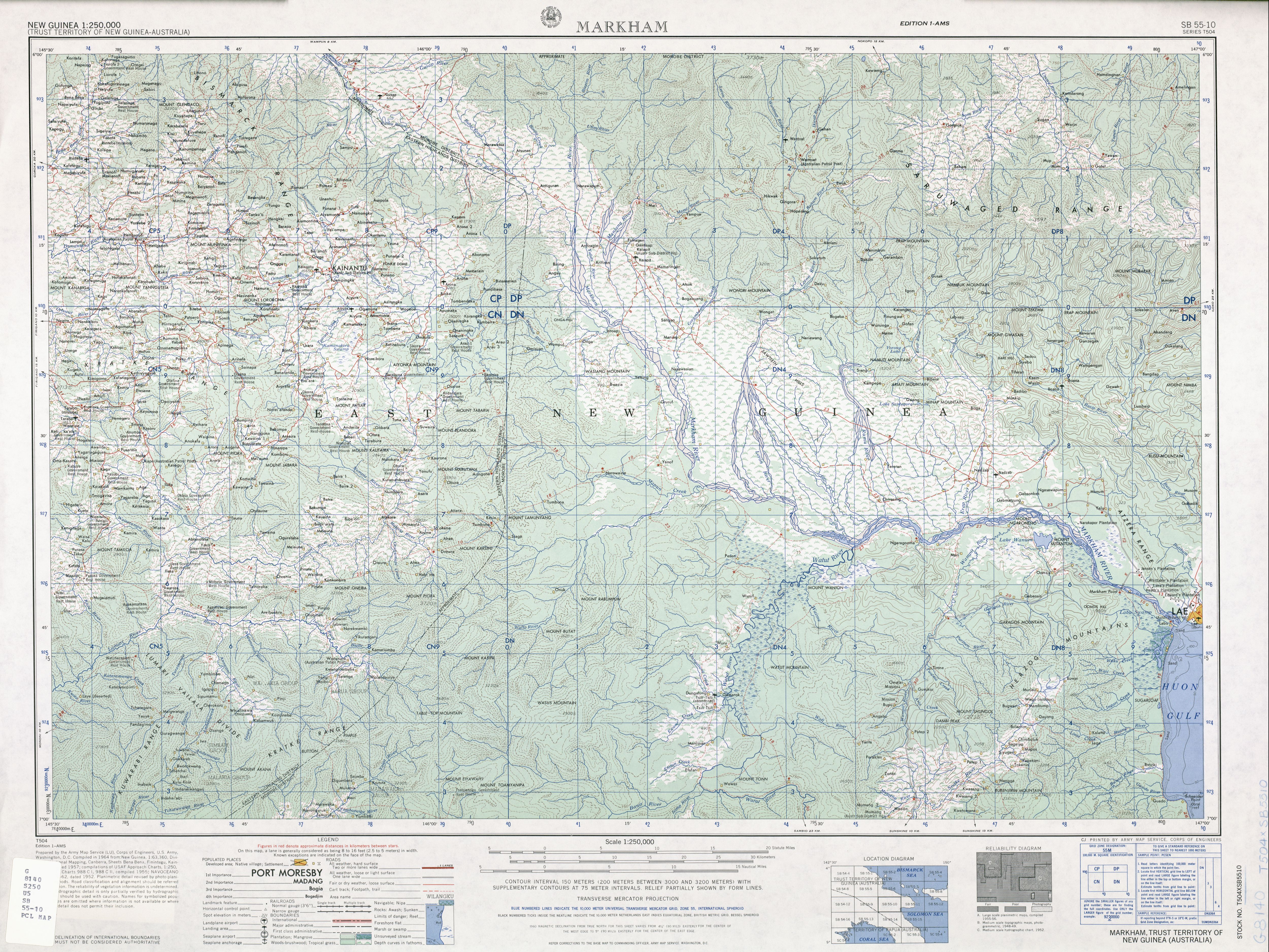
- ^ SB 55-10 Markham (5.4 MB). "Series T504, U.S. Army Map Service". Home > Finding Information > PCL Map Collection > New Guinea AMS Topographic Maps. University of Texas at Austin. Retrieved 4 March 2014.
{{cite web}}: CS1 maint: numeric names: authors list (link) - ^ Miller (jnr), John. "CHAPTER XI The Markham Valley and the Huon Peninsula". Hyperwar. Retrieved 28 February 2014.
- ^ "The Leaders". The News. Adelaide: National Library of Australia. 8 December 1944. p. 2. Retrieved 9 February 2014.
- ^ Critical Past. "Australian 7th Division takes over Lae and raises the Australian flag in New Guinea during World War II". Critical Past. Retrieved 25 February 2014.
- ^ "Beef Herd To Start in Lae". The Farmer and Settler (NSW : 1906 – 1957). NSW: National Library of Australia. 8 October 1954. p. 11. Retrieved 9 February 2014.
- ^ Sinclair, James. Stewart, Flora Shaw (1886–1979). Australian Dictionary of Biography. Retrieved 25 February 2014.
{{cite book}}:|work=ignored (help) - ^ "History". Morobe Province Agricultural Society. Archived from the original on 6 November 2014. Retrieved 10 September 2014.
- ^ 1957 Anutu Conquers in New Guinea: A Story of Seventy Years of Mission Work in New Guinea [2]
- ^ Sinclair, J.P 1998, Golden gateway: Lae & the Province of Morobe Crawford House, ISBN 1863331492, 9781863331494 [3] accessed 31 January 2014
- ^
 This article incorporates public domain material from the Air Force Historical Research Agency
- ^ Maurer, Maurer (1983). Air Force Combat Units of World War II. Maxwell AFB, Alabama: Office of Air Force History. ISBN 0-89201-092-4.
- ^ "World War II Pacific and Korean War". Pacific Wrecks. Retrieved 7 January 2016.
- ^ "History of Morobe". Lae City Council. Morobe Provincial government. Archived from the original on 19 February 2015. Retrieved 10 September 2014.
- ^ a b 1996 KAITILLA, S & YAMBUI, A Intervention in PNG: The Case of Lae, Disaster Management and Government
- ^ RSOE EDIS. "Flood in Papua New Guinea on Tuesday, 14 August, 2007". Archived from the original on 26 February 2014. Retrieved 23 February 2014.
- ^ "Lae City Council". Morobepng.com. Archived from the original on 19 February 2015. Retrieved 7 January 2016.
- ^ AAP (25 September 2011). "Aussies account for Kumuls in PNG". ABC News. Retrieved 26 September 2011.
See also[edit]
- List of former German colonies
- German New Guinea Company
- Brandenburger Gold Coast
- Imperial Colonial Office
- Reichskolonialbund
- Wilhelminism
- New Guinea
- List of colonial heads of New Guinea
- Unserdeutsch language
- Kaiser-Wilhelmsland
- HMAS AE1 (first Australian submarine)
Further reading[edit]
- Peter Biskup: Hahl at Herbertshoehe, 1896–1898: The Genesis of German Native Administration in New Guinea, in: K. S. Inglis (ed.): History of Melanesia, Canberaa – Port Moresby 1969, 2nd ed. 1971, 77–99.
- Firth, Stewart: Albert Hahl: Governor of German New Guinea. In: Griffin, James, Editor : Papua New Guinea Portraits: The Expatriate Experience. Canberra: Australian National University Press; 1978: 28–47.
- Firth, S. G.: The New Guinea Company, 1885–1899: A Case of Unprofitable Imperialism. in: Historical Studies. 1972; 15: 361–377.
- Firth, Stewart G.: Arbeiterpolitik in Deutsch-Neuguinea vor 1914. In: Hütter, Joachim; Meyers, Reinhard; Papenfuss, Dietrich, Editors: Tradition und Neubeginn: Internationale Forschungen zur deutschen Geschichte im 20. Jahrhundert. Köln: Carl Heymanns Verlag KG; 1975: 481–489.
- Noel Gash – June Whittaker: A pictorial history of New Guinea, Jacaranda Press: Milton, Queensland 1975, 312 p., ISBN 186273 025 3.
- Whittaker, J L; Gash, N. G.; Hookey, J. F.; and Lacey R. J. (eds.) : Documents and Readings in New Guinea History: Prehistory to 1889, Jacaranda Press: Brisbane 1975/1982
- Firth, Stewart: German Firms in the Western Pacific Islands, 1857–1914. in: Journal of Pacific History. 1973; 8: 10–28.
- Firth, Stewart G.: German Firms in the Pacific Islands, 1857– 1914. In: Moses, John A.; Kennedy, Paul M., Editors. Germany in the Pacific and Far East, 1870–1914. St. Lucia: University of Queensland Press; 1977: 3–25
- Firth, Stewart: German New Guinea: The Archival Perspective. in: Journal of Pacific History. 1985; 20: 94–103.
- Firth, Stewart: The Germans in New Guinea. In: May, R. J.; Nelson, Hank, Editors: Melanesia: Beyond Diversity. Canberra: Australian National University, Research School of Pacific Studies; 1982: 151–156.
- Firth, Stewart: The Transformation of the Labour Trade in German New Guinea, 1899–1914. in: Journal of Pacific History. 1976; 11: 51–65.
- Firth, Stewart. Labour in German New Guinea. In: Latukefu, Sione, Editor. Papua New Guinea: A Century of Colonial Impact 1884–1984. Port Moresby: The National Research Institute and the University of Papua New Guinea in association with the PNG Centennmial Committee; 1989: 179–202.
- Moses, John, and Kennedy, Paul, Germany in the Pacific and Far East 1870–1914, St Lucia Qld: Queensland University Press, 1977. ISBN 9780702213304
- Sack, Peter, ed., German New Guinea: A Bibliography, Canberra ACT: Australian National University Press, 1980, ISBN 9780909596477
- Firth, Stewart: New Guinea Under the Germans, Melbourne University Press : International Scholarly Book Services: Carlton, Vic. 1983, ISBN 9780522842203, reprinted by WEB Books: Port Moresby 1986, ISBN 9980570105.
- Foster, Robert J. "Komine and Tanga: A Note on Writing the History of German New Guinea", Journal of Pacific History (1987) 22#1 56–64; historiography.
- Mary Taylor Huber: The Bishops’ Progress. A Historical Ethnography of Catholic Missionary Experience of Catholic Missionary Experience on the Sepik Frontier, Smithsonian Institution Press: Washington and London 1988, 264 pp., ISBN 0-87474-544-6.
- Mary Taylor Huber: The Bishops’ Progress: Representations of Missionary Experience on the Sepik Frontier, in: Nancy Lutkehaus (ed.): Sepik Heritage. Tradition and Change in Papua New Guinea, Crawford House Press: Bathurst, NSW (Australia) 1990, 663 pp. + 3 maps, ISBN 1-86333-014-3., pp. 197–211.
- Keck, Verena. "Representing New Guineans in German Colonial Literature", Paideuma: Mitteilungen zur Kulturkunde (2008), Vol. 54, pp 59–83.
| Colonies |
| |||||
|---|---|---|---|---|---|---|
| Concessions |
| |||||
| Unrecognised |
| |||||

States of the German Empire (1871–1918) | ||
|---|---|---|
| Kingdoms |
| -en.png) |
| Grand Duchies | ||
| Duchies | ||
| Principalities | ||
| City-states | ||
| Imperial Territories | ||
| Other | ||
| Colonies |
| |||||
|---|---|---|---|---|---|---|
| Concessions |
| |||||
| Unrecognised |
| |||||