
Garor
(Redirected from Garvar)
Garor
گرور | |
|---|---|
village | |
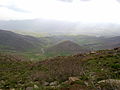
 village view | |
 Garor | |
| Coordinates: 36°24′39″N 45°26′15″E / 36.41083°N 45.43750°E | |
| Country | |
| Province | West Azerbaijan |
| County | Sardasht |
| Bakhsh | Vazineh |
| Rural District | Gavork-e Nalin |
| Population (2006) | |
| • Total | 234 |
| Time zone | UTC+3:30 (IRST) |
| • Summer (DST) | UTC+4:30 (IRDT) |
Garor (Persian: گرور; also known as Garvar)[1] is a village in Gavork-e Nalin Rural District, Vazineh District, Sardasht County, West Azerbaijan Province, Iran. At the 2006 census, its population was 234, in 40 families.[2]
Tourist Attractions[edit]
Every year a large number of people from other parts of Iran and other countries, comes to Garor.
-
 Perspective of Garor
 -
 "Xale Same" Foothills in Garor
 -
 "Kawlan" Fountain in Garor


Tribes[edit]
The tribes of Garor includes Khezri, Rasooli, Ahmadali, Ahmadani, Sorani, Gedrouni, Mohammadzadegan, Alizadeh, Pasandideh, Kabiri, Aboubakri, Hassani, Osmani, Hassanzade, Ahmadi and Hoveyda
References[edit]
- ^ Garvar can be found at GEOnet Names Server, at this link, by opening the Advanced Search box, entering "-3063685" in the "Unique Feature Id" form, and clicking on "Search Database".
- ^ "Census of the Islamic Republic of Iran, 1385 (2006)" (Excel). Statistical Center of Iran. Archived from the original on 2011-09-20.
This Sardasht County location article is a stub. You can help Wikipedia by expanding it. |