
Gírová
| Gírová | |
|---|---|
| Girowa | |
 Gírová seen from Moravian-Silesian Beskids | |
| Highest point | |
| Elevation | 840 m (2,760 ft) |
| Prominence | 235 m (771 ft) |
| Isolation | 5.5 km (3.4 mi) |
| Coordinates | 49°31′54″N 18°47′59″E / 49.53167°N 18.79972°E |
| Geography | |
 Gírová Location in the Czech Republic | |
| Location | Czech Republic |
| Parent range | Silesian Beskids |
| Climbing | |
| Easiest route | Hike |
Gírová[1] (Polish: Girowa) is an 840-metre-high (2,756 ft) mountain in the Silesian Beskids mountain range, in the Moravian-Silesian Region, Czech Republic. The mountain is located several kilometers from the borders with Poland and Slovakia.
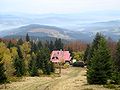
There is a mountain hut on the mountain, at the elevation of 790 m (2,592 ft). It was opened on 16 October 1932 by the Club of Czechoslovak Tourists.[2] Six year afterwards, the hut was rented by Franciszek Schulhauser, who has been administering it until 1967. During the communist era, the hut was owned by several state companies, and was not fully opened to the tourists. It was only on 4 September 1993, when the hut was fully opened.[2]
There are two tourist trails leading to Gírová. One can reach the mountain from Mosty u Jablunkova (Mosty koło Jabłonkowa) and Bukovec (Bukowiec), the second one from Jablunkov (Jabłonków).
-
 Mountain hut
 -
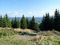
 View from Gírová in the southeast direction
 -
 At the summit of the mountain


Footnotes[edit]
References[edit]
- Barański, Mirosław J. (1996). Beskid Śląski. Pasmo Stożka i Czantorii. Przewodnik turystyczny. Warszawa: Wydawnictwo PTTK "Kraj". ISBN 83-7005-370-X.
- Cicha, Irena (2007). Beskidzkie gronie nad Olzą i Wisłą. Czeski Cieszyn: Vydavatelství Regio. pp. 36–65. ISBN 978-80-254-0261-0.