
File:Tacony, St. Leo the Great Catholic Church, Located at northern end of block bounded by Tulip and Keystone Streets, and Magee and Unruh Avenues, Philadelphia, Philadelphia County, PA HABS PA-6692-B-2.tif

Size of this JPG preview of this TIF file: 485 × 599 pixels. Other resolutions: 194 × 240 pixels | 388 × 480 pixels | 621 × 768 pixels | 828 × 1,024 pixels | 1,657 × 2,048 pixels | 4,392 × 5,428 pixels.
Original file (4,392 × 5,428 pixels, file size: 22.74 MB, MIME type: image/tiff)
| This is a file from the Wikimedia Commons. Information from its description page there is shown below. Commons is a freely licensed media file repository. You can help. |
Summary
| - Tacony, St. Leo the Great Catholic Church, Located at northern end of block bounded by Tulip and Keystone Streets, and Magee and Unruh Avenues, Philadelphia, Philadelphia County, PA | ||||
|---|---|---|---|---|
| Title |
- Tacony, St. Leo the Great Catholic Church, Located at northern end of block bounded by Tulip and Keystone Streets, and Magee and Unruh Avenues, Philadelphia, Philadelphia County, PA |
|||
| Description |
Watson, Frank R; Cavanaugh, Nicholas; Price, Virginia Barrett, transmitter; Jacobs, James A, historian; Elliott, Joseph, photographer |
|||
| Depicted place | Pennsylvania; Philadelphia County; Philadelphia | |||
| Date | Documentation compiled after 1933 | |||
| Dimensions | 4 x 5 in. | |||
| Current location |
Library of Congress Prints and Photographs Division Washington, D.C. 20540 USA http://hdl.loc.gov/loc.pnp/pp.print |
|||
| Accession number |
HABS PA-6692-B-2 |
|||
| Credit line |
|
|||
| Notes |
|
|||
| Source | https://www.loc.gov/pictures/item/pa3913.photos.213464p | |||
| Permission (Reusing this file) |
|
|||

File history
Click on a date/time to view the file as it appeared at that time.
| Date/Time | Thumbnail | Dimensions | User | Comment | |
|---|---|---|---|---|---|
| current | 07:41, 1 August 2014 | 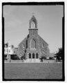 | 4,392 × 5,428 (22.74 MB) | Fæ | GWToolset: Creating mediafile for Fæ. HABS 31 July 2014 (3000:3200) |
File usage
The following pages on the English Wikipedia use this file (pages on other projects are not listed):