
File:Perchtoldsdorf (3).JPG

Size of this preview: 800 × 578 pixels. Other resolutions: 320 × 231 pixels | 640 × 463 pixels | 1,024 × 740 pixels | 1,280 × 925 pixels | 2,560 × 1,850 pixels | 3,898 × 2,817 pixels.
Original file (3,898 × 2,817 pixels, file size: 10.2 MB, MIME type: image/jpeg)
| This is a file from the Wikimedia Commons. Information from its description page there is shown below. Commons is a freely licensed media file repository. You can help. |
Summary
| Description |
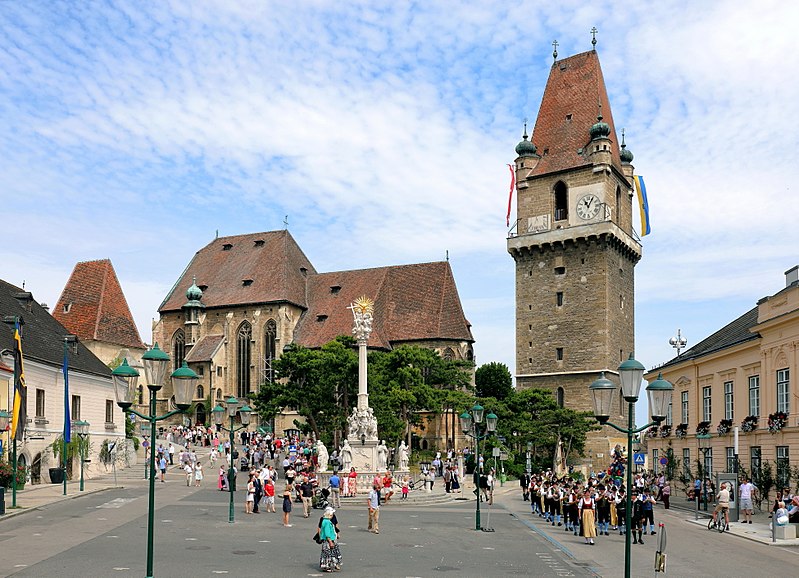
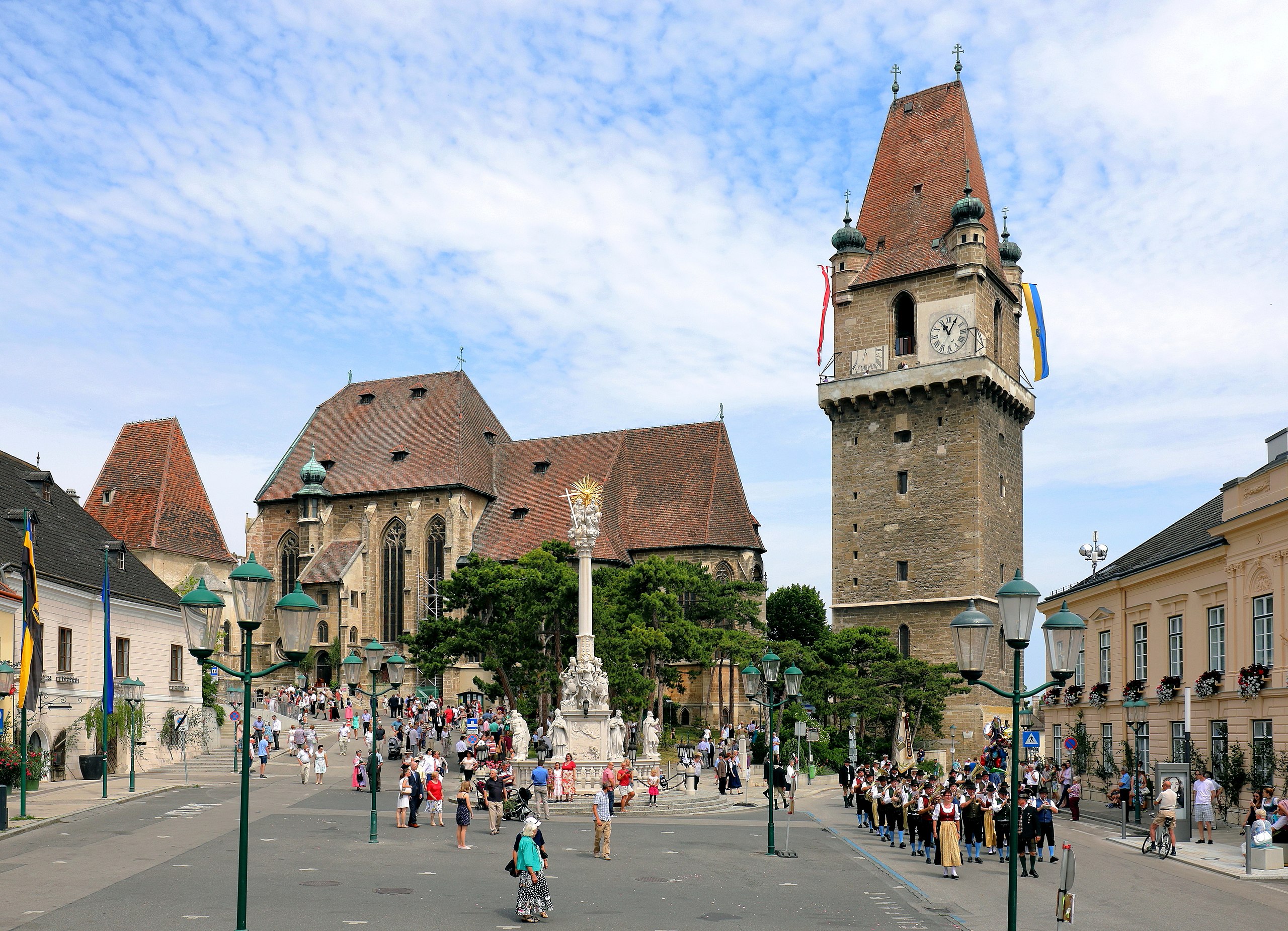
Deutsch: Der Marktplatz der niederösterreichischen Marktgemeinde Perchtoldsdorf. Links das sogenannte Regenharthaus, ein Bürgerhaus mit einer Kernsubstanz aus dem 15. Jahrhundert und hinter diesem die Martinskapelle bzw. der ehemalige Karner mit dem steilem Keildach. In der Bildmitte die Pfarrkirche hl. Augustinus und vor dieser die barocke Dreifaltigkeitssäule. Rechts der Wehrturm, ein von 1450 bis 1521 erbauter fünfgeschoßiger Turm, und ganz rechts das Gemeindeamt, ein ehemaliger späthistoristischer Meierhof aus dem Jahr 1838. Die Aufnahme wurde am Perchtoldsdorfer Fronleichnamstag gemacht, der gegenüber dem „regulären“ Fronleichnamstag um 10 Tage später gefeiert wird. |
| Date | |
| Source | Own work |
| Author | C.Stadler/Bwag |
| Permission (Reusing this file) |
Deutsch: Hallo, du darfst mein Foto kostenlos nutzen, aber nenne mich bitte als Fotograf, beispielsweise „Foto: C.Stadler/Bwag“ oder © C.Stadler/Bwag; CC-BY-SA-4.0. Auf mehr Angaben bestehe ich nicht - im Gegensatz zu manch anderen, die die Vorgaben der unten angeführten Lizenzierung auf Punkt und Beistrich einfordern. English: Feel free to use my photos, but please mention me as the author like © C.Stadler/Bwag or © C.Stadler/Bwag; CC-BY-SA-4.0 (that's good enough) and if you want send me a message: bwag@gmx.net. |
| Other versions |
|
.JPG)

.JPG)
| Camera location | | View this and other nearby images on: OpenStreetMap |
|---|
.JPG¶ms=048.118930_N_0016.265310_E_globe:Earth_type:camera_heading:335.00&language=en)
Licensing
I, the copyright holder of this work, hereby publish it under the following license:
This file is licensed under the Creative Commons Attribution-Share Alike 4.0 International license.
- You are free:
- to share – to copy, distribute and transmit the work
- to remix – to adapt the work
- Under the following conditions:
- attribution – You must give appropriate credit, provide a link to the license, and indicate if changes were made. You may do so in any reasonable manner, but not in any way that suggests the licensor endorses you or your use.
- share alike – If you remix, transform, or build upon the material, you must distribute your contributions under the same or compatible license as the original.
File history
Click on a date/time to view the file as it appeared at that time.
| Date/Time | Thumbnail | Dimensions | User | Comment | |
|---|---|---|---|---|---|
| current | 17:39, 7 July 2017 | | 3,898 × 2,817 (10.2 MB) | Bwag | b |
| 17:28, 7 July 2017 |  | 3,898 × 2,817 (9.87 MB) | Bwag | {{Information |Description= {{de|1=Der Marktplatz von der niederösterreichischen Marktgemeinde Perchtoldsdorf. Links das sogenannte Regenharthaus, ein Bürgerhaus mit einer Kernsubstanz aus dem 15. Jahrhundert und hinter diesem... |
File usage
More than 100 pages use this file. The following list shows the first 100 pages that use this file only. A full list is available.
.JPG)
- Aggstein Castle
- Aichelberg Castle
- Ambras Castle
- Bernstein Castle
- Burg Freiberg
- Burg Geyersberg
- Burg Greifenstein
- Burg Grub
- Burg Haimburg
- Burg Hardegg
- Burg Hartenstein
- Burg Heidenreichstein
- Burg Karlstein
- Burg Lockenhaus
- Burg Mannsberg
- Burg Neudenstein
- Burg Schlaining
- Burg Sommeregg
- Burgruine Araburg
- Burgruine Dietrichstein
- Burgruine Dobra
- Burgruine Falkenstein (Oberfalkenstein)
- Burgruine Federaun
- Burgruine Finkenstein
- Burgruine Flaschberg
- Burgruine Glanegg
- Burgruine Gmünd
- Burgruine Goldenstein
- Burgruine Gomarn
- Burgruine Gradenegg
- Burgruine Grafenstein
- Burgruine Greifenfels
- Burgruine Griffen
- Burgruine Groppenstein
- Burgruine Grünburg
- Burgruine Gurnitz
- Burgruine Hardegg
- Burgruine Hartneidstein
- Burgruine Himmelberg
- Burgruine Hohenburg auf Rosenberg
- Burgruine Hohenwart
- Burgruine Kaja
- Burgruine Karlsberg
- Burgruine Kollmitz
- Burgruine Kühnburg
- Burgruine Lavant
- Burgruine Leobenegg
- Burgruine Leonstein
- Burgruine Lichtengraben/Painburg
- Burgruine Liebenfels
- Burgruine Liemberg
- Burgruine Moosburg/Arnulfsfeste
- Burgruine Nussberg
- Burgruine Ortenburg
- Burgruine Petersberg
- Burgruine Ras
- Burgruine Rauchenkatsch
- Burgruine Rauterburg
- Burgruine Rechberg
- Burgruine Reifnitz
- Burgruine Reinegg
- Burgruine Reisberg
- Burgruine Rothenthurn
- Burgruine Rottenstein
- Burgruine Schaumburg
- Burgruine Silberberg
- Burgruine Sonegg
- Burgruine Sternberg
- Burgruine Steuerberg
- Burgruine Straßfried
- Burgruine Taggenbrunn
- Burgruine Treffen
- Burgruine Twimberg
- Burgruine Waisenberg
- Burgruine Weidenburg
- Burgruine Weißenegg
- Burgruine Wullroß
- Dürnstein Castle
- Eggenberg Palace, Graz
- Eschelberg
- Falkenstein Castle (Lower Austria)
- Falkenstein Castle (Niederfalkenstein)
- Feldsberg Castle
- Forchtenstein Castle
- Franzensburg
- Güssing Castle
- Hochosterwitz Castle
- Hohensalzburg Fortress
- Hohenwerfen Castle
- Kufstein Fortress
- Landskron Castle (Carinthia)
- Liechtenstein Castle (Maria Enzersdorf)
- List of Gothic architecture
- List of castles in Austria
- Neu-Ems Castle
- Prägrad Castle
- Rabenstein Castle (Carinthia)
- Schattenburg
- Schloss Hollenburg
- Schloss Ort
View more links to this file.
Global file usage
The following other wikis use this file:
- Usage on cs.wikipedia.org
- Usage on de.wikipedia.org
- Usage on www.wikidata.org
.JPG)