
Burgruine Araburg
You can help expand this article with text translated from the corresponding article in German. (July 2009) Click [show] for important translation instructions.
|
| Burgruine Araburg | |
|---|---|
| Kaumberg, Lower Austria | |
 Northeast view of Araburg | |
| Coordinates | 48°00′39″N 15°52′03″E / 48.01082°N 15.86741°E |
| Site information | |
| Condition | In ruins |
| Site history | |
| Built | 1180 |
Burgruine Araburg is a castle in Lower Austria, Austria. Burgruine Araburg is 776 metres (2,546 ft) above sea level, making it the highest castle ruin in Lower Austria.[1][2]
Gallery[edit]
-
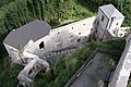 East side of Araburg castle seen from the keep
 -
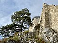 Araburg ruins
 -
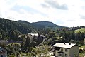 Burgruine Araburg on top of the hill seen from Kaumberg


See also[edit]
References[edit]
- ^ Burgruine Araburg Altitude and Position
- ^ "Araburg". Wienerwald. Retrieved 2020-07-27.


.JPG)
.JPG)


This Lower Austria location article is a stub. You can help Wikipedia by expanding it. |
This article about a castle in Austria is a stub. You can help Wikipedia by expanding it. |