
File:Auckland Volcanic Field.jpg

Size of this preview: 450 × 600 pixels. Other resolutions: 180 × 240 pixels | 360 × 480 pixels | 576 × 768 pixels | 768 × 1,024 pixels | 1,536 × 2,048 pixels.
Original file (1,536 × 2,048 pixels, file size: 585 KB, MIME type: image/jpeg)
| This is a file from the Wikimedia Commons. Information from its description page there is shown below. Commons is a freely licensed media file repository. You can help. |
Summary
| Description |
English: Auckland Volcanic Field Map |
| Date | |
| Source | File:Map_of_the_Auckland_urban_area,_2009,_cropped.jpg |
| Author | Ulanwp |
Licensing
I, the copyright holder of this work, hereby publish it under the following licenses:
This file is licensed under the Creative Commons Attribution-Share Alike 3.0 Unported license.
- You are free:
- to share – to copy, distribute and transmit the work
- to remix – to adapt the work
- Under the following conditions:
- attribution – You must give appropriate credit, provide a link to the license, and indicate if changes were made. You may do so in any reasonable manner, but not in any way that suggests the licensor endorses you or your use.
- share alike – If you remix, transform, or build upon the material, you must distribute your contributions under the same or compatible license as the original.

|
Permission is granted to copy, distribute and/or modify this document under the terms of the GNU Free Documentation License, Version 1.2 or any later version published by the Free Software Foundation; with no Invariant Sections, no Front-Cover Texts, and no Back-Cover Texts. A copy of the license is included in the section entitled GNU Free Documentation License. |
You may select the license of your choice.
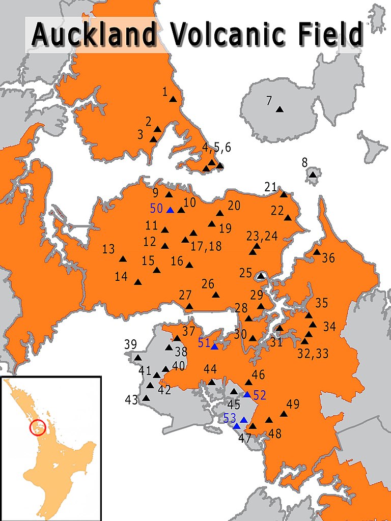
Key
- Pupuke Volcano
- Tank Farm
- Onepoto
- Mount Victoria
- Mount Cambria
- Maungauika
- Rangitoto
- Motukorea
- Albert Park Volcano
- Auckland Domain / Pukekawa Volcano
- Motukorea
- Te Pou Hawaiki
- Ōwairaka / Mount Albert
- Puketāpapa
- Te Tātua a Riukiuta
- Maungakiekie / One Tree Hill
- Mount Saint John
- Ōhinerau / Mount Hobson
- Little Rangitoto
- Ōrākei Basin
- Whakamuhu / Glover Park
- Taylors Hill
- Purchas Hill
- Maungarei
- Mount Smart
- Te Hopua a Rangi
- Mount Richmond
- McLennan Hills
- Robertson Hill
- Pukewairiki
- Hampton Park
- Ōtara Hill
- Green Hill
- Styaks Swamp
- Pigeon Mountain
- Māngere Mountain
- Māngere Lagoon
- Puketutu Island
- Waitomokia
- Pukeiti
- Ōtuataua
- Maungataketake
- Pukaki Lagoon
- Crater Hill
- Kohuora
- Matukutūreia
- Matukutūruru
- Ash Hill
- Grafton Volcano
- Boggust Park Crater
- Cemetery Crater
- Puhinui Craters
File history
Click on a date/time to view the file as it appeared at that time.
| Date/Time | Thumbnail | Dimensions | User | Comment | |
|---|---|---|---|---|---|
| current | 21:58, 19 April 2016 | | 1,536 × 2,048 (585 KB) | Ulanwp | {{Information |Description ={{en|1=Auckland Volcanic Field Map}} |Source =https://commons.wikimedia.org/wiki/File:Map_of_the_Auckland_urban_area,_2009,_cropped.jpg |Author =Ulanwp |Date =2016-04-19 |Permissi... |
File usage
The following pages on the English Wikipedia use this file (pages on other projects are not listed):
- Albert Park Volcano
- Ash Hill, New Zealand
- Auckland Domain
- Auckland volcanic field
- Boggust Park Crater
- Cemetery Crater
- Crater Hill
- Grafton Volcano
- Green Hill, New Zealand
- Hampton Park, New Zealand
- Ihumātao
- Kohuora
- Lake Pupuke
- Little Rangitoto
- Matukutūreia
- Matukutūruru
- Maungakiekie / One Tree Hill
- Maungarei
- Maungataketake
- Maungawhau / Mount Eden
- McLennan Hills
- Motukorea
- Mount Cambria
- Mount Saint John (New Zealand)
- Mount Smart
- Mount Victoria (Auckland)
- Māngere Lagoon
- Māngere Mountain
- North Head (New Zealand)
- Onepoto (volcanic crater)
- Panmure Basin
- Pigeon Mountain (New Zealand)
- Puhinui Craters
- Pukaki Lagoon
- Pukeiti (Auckland)
- Puketutu Island
- Puketāpapa
- Pukewairiki
- Purchas Hill
- Rangitoto Island
- Robertson Hill
- Styaks Swamp
- Tank Farm
- Taurere / Taylor Hill
- Te Hopua a Rangi
- Te Pou Hawaiki
- Te Tātua a Riukiuta
- Waitomokia
- Ōhinerau / Mount Hobson
- Ōrākei Basin
- Ōtara Hill
- Ōtāhuhu / Mount Richmond
- Ōwairaka / Mount Albert
- Template:Auckland volcanic field
Global file usage
The following other wikis use this file:
- Usage on de.wikipedia.org
- Usage on fr.wikipedia.org
- Usage on hu.wikipedia.org
- Usage on www.wikidata.org