
Easterlittens
Oosterlittens
Easterlittens | |
|---|---|
Village | |
 | |
 Flag  Coat of arms | |
 Location in the former Littenseradiel municipality | |
 Oosterlittens Location in the Netherlands  Oosterlittens Oosterlittens (Netherlands) | |
| Coordinates: 53°8′6″N 5°38′58″E / 53.13500°N 5.64944°E | |
| Country | |
| Province | |
| Municipality | |
| Area | |
| • Total | 6.20 km2 (2.39 sq mi) |
| Elevation | 0.5 m (1.6 ft) |
| Population (2021)[1] | |
| • Total | 465 |
| • Density | 75/km2 (190/sq mi) |
| Postal code | 8835[1] |
| Dialing code | 0517 |
Easterlittens (Dutch: Oosterlittens) is a village in Leeuwarden in the province of Friesland, the Netherlands. It had a population of around 439 in January 2017.[3]
History[edit]
The village was first mentioned in the second half of the 13th century as Lechinke. The etymology is unclear.[4] Easterlittens is a terp (artificial living mound) village which developed along the Franekervaart. The terp has been partially excavated at the end of the 19th century. The Dutch Reformed Church has 12th century elements. The tower dates from 1854.[5] The little tower was blown off the church in a storm in 1969, and was restored and put back in 1971, but without the original bell which could not be found and was replaced by a ship's bell. In 1840, Easterlittens was home to 479 people.[6]
The windmill Alde Swarte Molen, Easterlittens is a polder mill from 1690. It used to drain excess water until 1961 when it was rendered obsolete by an electric pumping station. In 1967, it was bought by the municipality of Baarderadeel for ƒ 1,-. Since 1981, the wind mill is back in active service draining the polder of Oosterlittens-Britswerd.[7]
Before 2018, the village was part of the Littenseradiel municipality and before 1984 it belonged to Baarderadeel municipality.[6]
Gallery[edit]
-
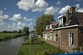
 View from the canal
 -
 Houses along the canal
 -
 Street view
 -
 Bridge of Easterlittens


References[edit]
- ^ a b c "Kerncijfers wijken en buurten 2021". Central Bureau of Statistics. Retrieved 30 March 2022.
two entries
- ^ "Postcodetool for 8835KV". Actueel Hoogtebestand Nederland (in Dutch). Het Waterschapshuis. Retrieved 30 March 2022.
- ^ Aantal inwoners per dorp Archived 2017-04-21 at the Wayback Machine - Littenseradiel
- ^ "Easterlittens - (geografische naam)". Etymologiebank (in Dutch). Retrieved 30 March 2022.
- ^ Ronald Stenvert & Sabine Broekhoven (2000). "Easterlittens" (in Dutch). Zwolle: Waanders. ISBN 90 400 9476 4. Retrieved 29 March 2022.
- ^ a b "Easterlittens". Plaatsengids (in Dutch). Retrieved 30 March 2022.
- ^ "Alde Swarte Molen". Molen database (in Dutch). Retrieved 30 March 2022.
External links[edit]
![]() Media related to Easterlittens at Wikimedia Commons
Media related to Easterlittens at Wikimedia Commons