
Coroieni
Coroieni | |
|---|---|
 Coroieni townhall | |
 Location in Maramureș County | |
 Coroieni Location in Romania | |
| Coordinates: 47°22′N 23°46′E / 47.367°N 23.767°E | |
| Country | Romania |
| County | Maramureș |
| Government | |
| • Mayor (2020–2024) | Gavril Ropan (PNL) |
| Area | 66.93 km2 (25.84 sq mi) |
| Elevation | 470 m (1,540 ft) |
| Population (2021-12-01)[1] | 2,438 |
| • Density | 36/km2 (94/sq mi) |
| Time zone | EET/EEST (UTC+2/+3) |
| Postal code | 437126 |
| Area code | +(40) x62 |
| Vehicle reg. | MM |
| Website | comunacoroieni |
Coroieni (Hungarian: Karulyfalva) is a commune in Maramureș County, Transylvania, Romania. It is composed of five villages: Baba (Bába), Coroieni, Dealu Mare (Dombhát), Drăghia (Drágosfalva), and Vălenii Lăpușului (Dánpataka).
The commune is situated at the northwestern edge of the Transylvanian Plateau, in the foothills of the Lăpuș Mountains. It is located in the southern part of Maramureș County, within the historical Țara Lăpușului region. It lies 15 km (9.3 mi) southwest of Târgu Lăpuș and 48 km (30 mi) southeast of the county seat, Baia Mare, on the border with Sălaj County.
At the 2021 census, Coroieni had a population of 2,438; of those, 63.7% were Romanians and 32.28% Roma.[2]
References[edit]
-
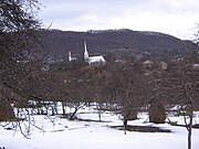 Coroieni
 -
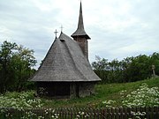
 Wooden church in Dealu Mare
 -
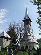
 Wooden church in Drăghia
 -
 Church of the Nativity of Virgin Mary in Vălenii Lăpușului


.JPG)


This Maramureș County location article is a stub. You can help Wikipedia by expanding it. |