
Corcubión
Corcubión | |
|---|---|
municipality | |
 | |
 Coat of arms | |
 Location of Corcubión within Galicia | |
| Area | |
| • Total | 6.58 km2 (2.54 sq mi) |
| Population (2018)[1] | |
| • Total | 1,578 |
| • Density | 240/km2 (620/sq mi) |
| Time zone | UTC+1 (CET) |
| • Summer (DST) | UTC+2 (CEST) |
| Website | www.corcubion.info/en |
Corcubión (AGAL ortography: Corcubiom) is a municipality in the province of A Coruña, in the autonomous community of Galicia, Spain. It belongs to the comarca of Fisterra.
It is located on the river with the same name.

History[edit]
Corcubión belonged to the county of Traba, but later passed into the hands of the Count of Altamira.
Linguistic status[edit]
The local government of the municipality was the first public institution to officially use the AGAL norm[citation needed] of the Galician language according to the Reintegrationism ideas, as seen in its website, offering options for "Galician" (NOMIGa) and "Galician-Portuguese" (AGAL), as well as Spanish and English.
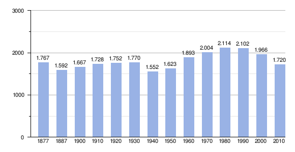
Demography[edit]
References[edit]
Official Website City Council of Corcubion
| International | |
|---|---|
| National | |
42°57′N 9°11′W / 42.950°N 9.183°W
- ^ Municipal Register of Spain 2018. National Statistics Institute.