
Bridge near Kemer
Bridge near Seydikemer | |
|---|---|
 The western ramp of the Bridge near Kemer | |
| Coordinates | 36°41′36″N 29°21′43″E / 36.693333°N 29.361944°E |
| Crosses | Xanthos river (Koca Çayı) |
| Locale | Near Xanthos, Lycia, Turkey |
| Characteristics | |
| Total length | 500+ m |
| Width | 4.5 m |
| History | |
| Construction end | Presumably 3rd century AD |
| Location | |
 | |
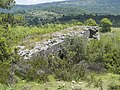
The Bridge near Seydikemer was a Roman segmental arch bridge near the ancient city of Xanthos in Lycia, in modern-day southwestern Turkey. Its remains are located on the upper reaches of the Xanthos river (Koca Çayı), 4 km upstream from the town of Seydikemer, at a site where the gravel river bed reaches a width of 500 m.[1] Only a 29 m long and 4.5 m wide section on the right river bank, outside the inundation zone, is left today, having once served as approach to the bridge proper.[2] Despite its near-complete destruction, the bridge represents a noteworthy example of the early use of segmental arches and hollow chambers in bridge building.
Structure[edit]
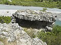
The visible remains still allow the identification of some, for their time, unusual construction techniques. The extant ramp features three arches of 4 to 4.45 m clear span, two of which, with an apex height of only 1 m, show a particularly flat profile.[3] Segmental arches are known only from a limited number of Roman bridges, and came into widespread use not until the late medieval period (see e.g. Ponte Vecchio). The third arch, in contrast, possesses the typically Roman semi-circular shape, with a span-to-rise ratio of 2 to 1.[3]
The arch vaults were constructed from locally hewn limestone ashlar which was bound by mortar; the interior of the bridge body was built of a rock-hard mixture of rubble and fluid mortar, which today lays bare at many places, shining through the crumbled facing.[3] The mortar consists of hard building lime with an admixture of fine gravel.[3] The pavement of the roadway has completely disappeared, but the constant gradient of the ramp indicates that the ancient paving stones lay directly on the present-day surface.[3]

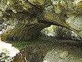
Another remarkable feature of the Seydikemer Bridge is the hollow chamber above the third arch vault, where the 2 m large gap between the arch crest and the roadway is not filled with the mortar mixture, but features in its interior a cut-out chamber measuring 3.5 m in length, 3.2 m in width and 1.5 m in height;[4] its purpose was to reduce the load resting on the arches, and to save building material.[3] A second, smaller inner chamber was found in the upper part of the second pier.[5] Similar hollow chamber systems are known from at least three other Roman bridges in Asia Minor, such as the Makestos Bridge, the Aesepus Bridge and the White Bridge.[6]
Circular ducts with a diameter of approximately 26 cm, which run through the length and width of the bridge, are interpreted as hollow forms of round construction timber of the Roman scaffolding and falsework.[7] In the third pier, which stands closest to the river bed, a small, arched floodway is integrated to let water pass.[7] Although the surviving ramp does not allow to determine the number and type of the arches of the bridge proper, the ancient structure must have been a rather impressive engineering feat, judging from its current height of 8 m above the sediments and the 500 m wide river bed which needed to be spanned.[7]
A well-preserved example of an ancient segmental arch bridge in Lycia is the twenty-eight arch Limyra Bridge, which was also investigated by the German archaeologists Wolfgang W. Wurster und Joachim Ganzert.
Dating[edit]
A possible starting point for the dating of the Seydikemer bridge provides a Roman road in the area which is known to have existed at the beginning of the 3rd century AD.[7] According to this interpretation, the bridge may have been part of a westward route from Kadyanda (Üzümlü), which descended further upstream into the Xanthos valley.[8] Possibly, the bridge can be also linked with the pass trail to Oinoanda.[8]
Gallery[edit]
-
 View from the western ramp
 -
 Remains seen from river
 -
 View from west
 -
 Hollow chamber below roadway
 -
 Second segmental arch


See also[edit]
References[edit]
- ^ Wurster & Ganzert 1978, pp. 304, 307
- ^ Wurster & Ganzert 1978, pp. 304, 306
- ^ a b c d e f Wurster & Ganzert 1978, p. 306
- ^ O’Connor 1993, p. 126
- ^ Wurster & Ganzert 1978, p. 305, fig. 19
- ^ Wurster & Ganzert 1978, p. 306, fn. 31
- ^ a b c d Wurster & Ganzert 1978, p. 307
- ^ a b Wurster & Ganzert 1978, p. 304
Sources[edit]
- O’Connor, Colin (1993), Roman Bridges, Cambridge University Press, p. 126 (E22), ISBN 0-521-39326-4
- Wurster, Wolfgang W.; Ganzert, Joachim (1978), "Eine Brücke bei Limyra in Lykien. Anhang: Reste einer Brücke oberhalb von Kemer am Oberlauf des Xanthos", Archäologischer Anzeiger (in German), Berlin: German Archaeological Institute, pp. 304–307, ISSN 0003-8105
External links[edit]
![]() Media related to Kemer Seydikemer at Wikimedia Commons
Media related to Kemer Seydikemer at Wikimedia Commons
