Blâme
| Blâme | |
|---|---|
 La Forge d'Ans | |
| Location | |
| Country | France |
| Physical characteristics | |
| Source | |
| • location | Dordogne |
| Mouth | |
• location | Auvézère |
• coordinates | 45°13′40″N 0°59′10″E / 45.22778°N 0.98611°E |
| Length | 6.1 km (3.8 mi) |
| Basin features | |
| Progression | Auvézère→ Isle→ Dordogne→ Gironde estuary→ Atlantic Ocean |
The Blâme (French: le Blâme), is a short river in the region of Nouvelle-Aquitaine in France. This 6.1 km (3.8 mi) long river is a left tributary of the Auvézère. It flows entirely within the department of Dordogne.[1]
Geography[edit]
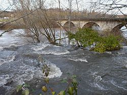
The Blâme is a left tributary of the Auvézère river.[1] It empties into the Auvézère slightly east of the commune of La Boissière-d'Ans with a small waterfall near La Forge d'Ans.[2] Its source is the spring Puits de Bontemps, 1.5 km south of Brouchaud.
The Blâme has one tributary, the small river Soue (also called Lassoue).[1] The two rivers join at the village of Brouchaud.
See also[edit]
References[edit]
- ^ a b c Sandre. "Fiche cours d'eau - Le Blâme (P6370500)".
- ^ Hoffmann, Frédéric (2005). Les tufs et travertins en Périgord-Quercy (in French). Bordeaux: University of Bordeaux Press. p. 154. ISBN 2-86781-379-4. Retrieved 18 May 2011.
External links[edit]
- The Dordogne equipment side (glossary) : see the article Artesian source, illustrated by a view of the Puits de Bontemps, available only in French (in French)


